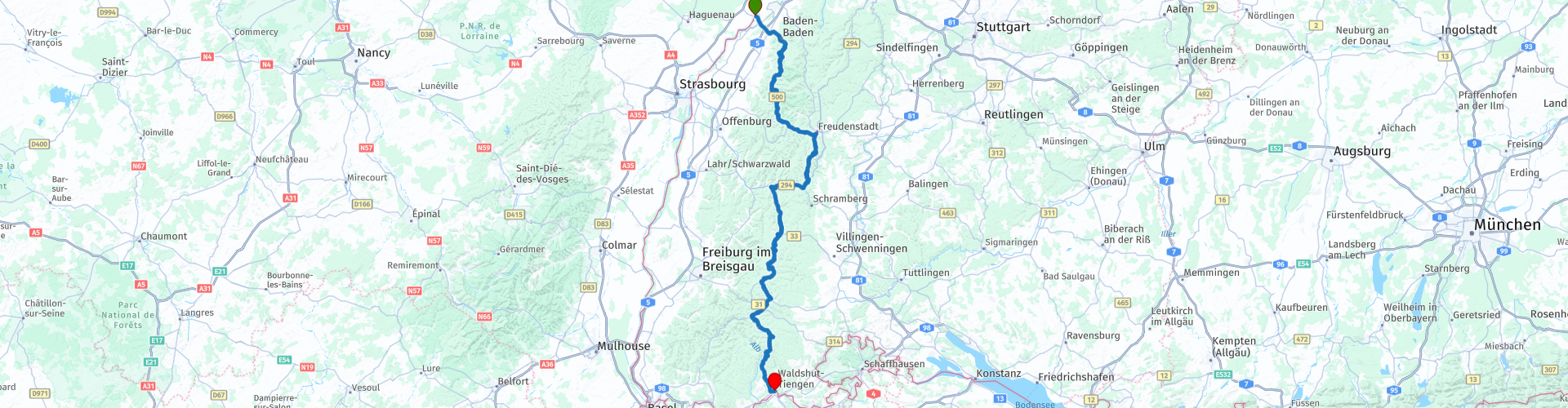
Van Baden Baden naar Waldshut Tiengen Dwars door het zwarte woud via de Schwarzwaldhochstrasse en de B500

This route was brought to you by:
RouteXpert Stijn Claus
Last edit: 23-03-2019
 Route Summary
 This route runs straight through the Black Forest, at an altitude between 800 and 1000 meters.
The road surface is in excellent condition.
 Share this route


Animation

Verdict


Duration
3h 42m

Mode of travel
Car or motorcycle

Distance
220.95 km

Countries

 RouteXpert Review
 First we follow the Northern B500, better known as the Schwarzwaldhochstraße.
The name Schwarzwaldhochstraße was first used in 1930 after the completion of the section of the road between Hundseck and Untersmatt. The road made access to the high Black Forest easier. Under the Third Reich, further construction was done for strategic reasons, including completing the piece between Ruhestein and Alexanderschanze (between 1938 and 1941). The entire route from Baden-Baden to Freudenstadt was completed in 1952.
This road starts in Baden-Baden and rises quickly to the most important ridge of the northern Black Forest and reaches the summit at the Bühlerhöhe. In clear weather there is a wide view over the plain of the Rhine towards the Vosges.
From the Bühlerhöhe, the Hochstraße runs at an altitude between 800 and 1,000 meters above sea level.
At the bottom of the highest mountain in the northern Black Forest, the Hornisgrinde 1,164 meters high, the road reaches the almost circular Mummelsee, a kettle valley from the last ice age
The road then continues over the Schliffkopf and Kniebis, past Zuflucht and the Alexanderschanze to end up in the city of Freudenstadt.
We then follow the B294 and then continue on the B33 to follow the B500 back to Switzerland at Trimberg im Swarzwald. The remaining part of the B500 traverses the southern Black Forest.
We pass on the Titisee and the Schuchsee and the viewpoint Gupfen viewpoint. When the weather is nice you have a wonderful view of the Swiss Alps, the Black Forest, the Hotzenwald and the Rhine plain.
The route ends again on the Rhine, which this time forms the border between Germany and Switzerland.


 Links
Links  Usage
Usage Want to download this route?
You can download the route for free without MyRoute-app account. To do so, open the route and click 'save as'. Want to edit this route?
No problem, start by opening the route. Follow the tutorial and create your personal MyRoute-app account. After registration, your trial starts automatically.  Disclaimer
Use of this GPS route is at your own expense and risk. The route has been carefully composed and checked by a MyRoute-app accredited RouteXpert for use on TomTom, Garmin and MyRoute-app Navigation.
Changes may nevertheless have occurred due to changed circumstances, road diversions or seasonal closures. We therefore recommend checking each route before use.
Preferably use the route track in your navigation system. More information about the use of MyRoute-app can be found on the website under 'Community' or 'Academy'.