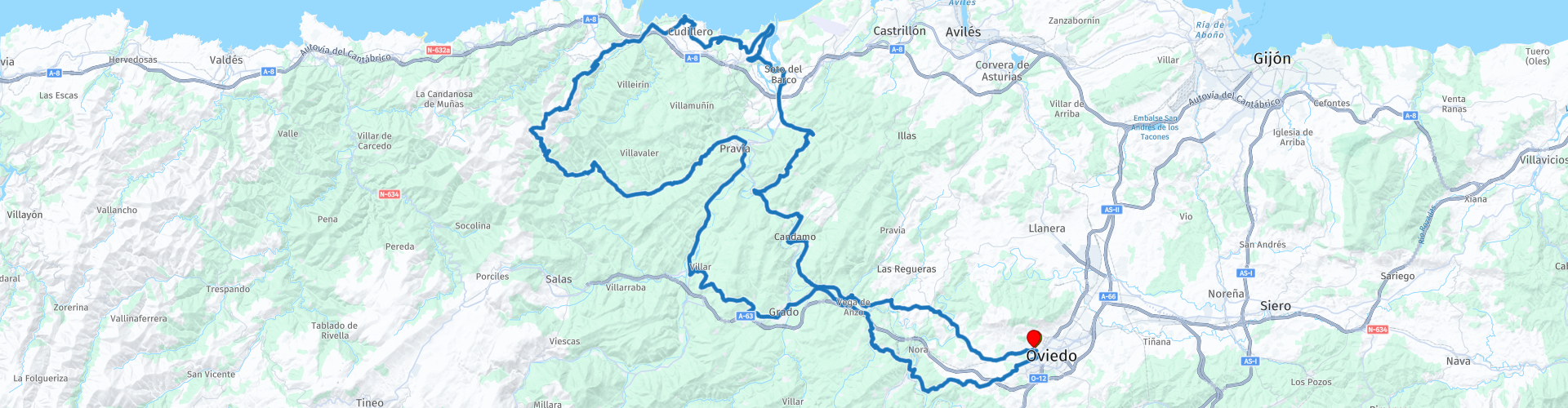
Round trip from Oviedo 4 Cudillero on the coast

This route was brought to you by:
RouteXpert Nick Carthew - (MRA Master)
Last edit: 23-06-2022
 Route Summary
  Share this route


Animation

Verdict


Duration
6h 55m

Mode of travel
Car or motorcycle

Distance
151.50 km

Countries

 RouteXpert Review
 A short route of about 150km, but what it lacks in distance is sure made up for by the roads and scenery and the beautiful setting for lunch.
Leaving Oviedo on the N-634 you are soon away from the hustle and bustle of city life and into the rural landscape.
The landscapes in Asturias are like no others in Spain and truly deserve exploring!
Travelling to the north, the route uses very small roads, some not more than farm tracks but all are surfaced and all offer you adventure as you head for the area known as: The Costa Verde, or Green Coast of Asturias. After crossing the River Nalón for the second time, (incidentally, you'll cross over this mighty river a further four times) you follow the river's path to Santoseso where you turn off and begin to climb up to 300m with great views of the empty river valley to your right. A very sharp left turn takes you onto a narrow road that only a handful of tourists will have used. It's the AS-316 and it will take you through the true countryside of Asturias on the way to the coast.
The third crossing of the River Nalón is just 3 km from where it enters the sea at San Esteban. This route takes you to a great viewpoint called Mirador del Espíritu Santo. The viewpoint receives this name from the Hermitage that can be found here. This viewpoint offers panoramic views of the rugged coast from where you can see the lighthouse at Cudillero, the mouth of the Nalón River and the nearby town of San Juan de La Arena.
Costa Verde is a literal treasure trove of hidden gems waiting to be discovered. Here, at the southern end of the Bay of Biscay, the Cantabrian Sea collides in spectacular fashion with mainland Spain to create an incredible diversity of stunning coastal landscapes. Anyone who travels to Asturias falls in love with its places, its people and with the feeling of having had a completely unique trip. There are several viewpoints to stop at and admire the beautiful coastline before reaching Cudillero.
Lunch stop at Cudillero.
You’d be forgiven for thinking that idyllic fishing villages like Cudillero no longer existed in Spain: Most seaside towns this picturesque have become tourist-heavy resorts with souvenir shops on every corner. Not for this small port, who have managed to keep their maritime spirit real. Upon arriving in this village, dozens of colourful houses on the hillside seem to be falling into the port like a waterfall. This is Cudillero, one of the most beautiful villages in Spain and has been compared to those on the Amalfi coast. The coastal atmosphere is evident with the images of fish drying on the doors of houses, the smell of the ozone, the beautiful light. At its centre is the Plaza de la Marina where you can choose to have lunch from the many restaurants.
The ancient narrow streets offer various paths that provide an abundance of great views to the sea. A bunch of historic buildings give an insight to the local cultural heritage: Gothic 16th century’s church, chapel of Humilladero, the lighthouse and fishermen taverns are the most popular attractions here. If you are wondering about the history behind the Crayola-coloured town, it’s quite simple: each family painted their home and boat the same colour so they would be easily recognisable from the sea. You will probably see curadillo hanging from the windows, a local speciality of sun-dried shark that used to be considered poor-man’s food but has since become a hallmark of Cudillero cuisine.
After lunch, it's a mixture of nature and man-made structures that the route passes by. First are the twin viaducts of the A-8 and N-622 roads. The way that these roads float across the Astaurian countryside on huge concrete pillars is like a scene from a Sci-Fi movie. The juxtaposition of mankind and mother nature is beautiful in its own right. The Concha de Artedo Viaduct is the highest bridge on Spain’s A8 Autovía del Cantábrico at 109m. Skirting along the coastline of Asturias, the A8 is one of Spain’s most beautiful highways with spectacular views of the Cantabrian Sea.
Not far from here the road begins to climb again, back into the mountains. The road becomes narrower and there are no less than 9 hairpin bends that will transport you what feels like the top of the world.
The Cudillero wind farm is situated on a mountain ridge and offers you breathtaking 360° views, back towards the coast and the surrounding countryside. The wind farm is actually called Baos Y Pumar wind farm and has a total of 36 turbines each capable of producing 850kw of energy using their 52m blades. There are other wind farms nearby all making use of the high ground giving this area a surreal feel. This is also the highest point of the route at 720m and what goes up must come down. The next 8km take you back down on the narrow SL-13 with 4 tight hairpin bends (I said it was adventurous :) )
When you make it back down to 'normal' roads again, the ride back to Oviedo is enjoyable as it travels through the beautiful countryside of Asturias.
Enjoy


 Links
Links  Usage
Usage Want to download this route?
You can download the route for free without MyRoute-app account. To do so, open the route and click 'save as'. Want to edit this route?
No problem, start by opening the route. Follow the tutorial and create your personal MyRoute-app account. After registration, your trial starts automatically.  Disclaimer
Use of this GPS route is at your own expense and risk. The route has been carefully composed and checked by a MyRoute-app accredited RouteXpert for use on TomTom, Garmin and MyRoute-app Navigation.
Changes may nevertheless have occurred due to changed circumstances, road diversions or seasonal closures. We therefore recommend checking each route before use.
Preferably use the route track in your navigation system. More information about the use of MyRoute-app can be found on the website under 'Community' or 'Academy'.

Asturias
About this region
Asturias (, Spanish: [asˈtuɾjas]; Asturian: Asturies [asˈtuɾjes; -ɾjɪs]), officially the Principality of Asturias (Spanish: Principado de Asturias; Asturian: Principáu d'Asturies; Galician-Asturian: Principao d'Asturias), is an autonomous community in northwest Spain.
It is coextensive with the province of Asturias and contains some of the territory that was part of the larger Kingdom of Asturias in the Middle Ages. Divided into eight comarcas (counties), the autonomous community of Asturias is bordered by Cantabria to the east, by León (Castile and León) to the south, by Lugo (Galicia) to the west, and by the Cantabrian sea to the north.
Asturias is situated in a mountainous setting with vast greenery and lush vegetation, making it part of Green Spain. The region has a maritime climate. It receives plenty of annual rainfall and little sunshine by Spanish standards and has very moderated seasons, most often averaging in the lower 20s celsius. Heatwaves are rare due to mountains blocking southerly winds. Winters are very mild for the latitude, especially near sea level.
The most important cities are the communal capital, Oviedo, the seaport and largest city Gijón, and the industrial town of Avilés. Other municipalities in Asturias include Cangas de Onís, Cangas del Narcea, Gozón, Grado, Langreo, Llanera, Laviana, Lena, Llanes, Mieres, Siero, Valdés, Vegadeo and Villaviciosa (see also List of municipalities and comarcas in Asturias).
Asturias is also home of the Princess of Asturias Awards.
Read more on Wikipedia
It is coextensive with the province of Asturias and contains some of the territory that was part of the larger Kingdom of Asturias in the Middle Ages. Divided into eight comarcas (counties), the autonomous community of Asturias is bordered by Cantabria to the east, by León (Castile and León) to the south, by Lugo (Galicia) to the west, and by the Cantabrian sea to the north.
Asturias is situated in a mountainous setting with vast greenery and lush vegetation, making it part of Green Spain. The region has a maritime climate. It receives plenty of annual rainfall and little sunshine by Spanish standards and has very moderated seasons, most often averaging in the lower 20s celsius. Heatwaves are rare due to mountains blocking southerly winds. Winters are very mild for the latitude, especially near sea level.
The most important cities are the communal capital, Oviedo, the seaport and largest city Gijón, and the industrial town of Avilés. Other municipalities in Asturias include Cangas de Onís, Cangas del Narcea, Gozón, Grado, Langreo, Llanera, Laviana, Lena, Llanes, Mieres, Siero, Valdés, Vegadeo and Villaviciosa (see also List of municipalities and comarcas in Asturias).
Asturias is also home of the Princess of Asturias Awards.
View region
 Statistics
  16
16Amount of RX reviews (Asturias)
 22441
22441Amount of visitors (Asturias)
 1293
1293Amount of downloads (Asturias)
 Route Collections in this region
 Three tours in and around Picos de Europa Northern Spain
The Picos de Europa is a mountainous area in northern Spain, next to the Basque Country. In the middle is the village of Posada de Valdeon, which cannot be reached by motorbike from the north: you have to drive around the Picos via Potes or Sames. We stayed overnight in Posada de Valdeon in Hostal Casa Abascal. A great hotel with breakfast option. You can eat in a restaurant in the village with usually a choice of two menus.
There are all kinds of nature reserves around the Picos. These three routes take you through some of them. There are gorges to see, viewpoints, reservoirs and you can walk more than fine. If you like walking, bring your walking shoes.
But we come to ride and it's going great. Excellent roads with the occasional piece of unpaved so that you do not have to detour far for another attraction. You can eat delicious food and the people are very nice and hospitable. And because the route to Lourdes goes above the Picos, there are also pilgrimage sites and very beautiful churches and monasteries. The most beautiful thing in this area is the nature: breathtakingly beautiful with wild animals, rugged mountains and wild rivers.
All in all, you can spend at least 4 days here if you take a day of rest or go for a walk.
View Route Collection
Santander to Roscoff via Picos de Europa Pyrenees West coast of France
A tour with 9 routes that all link up, starting from the ferry port of Santander to Potes using lots of twisty roads. The next route is a truly memorable round tour from Potes of the ever popular Picos de Europa. Then the tour heads south and east past reservoirs and picking up the mighty Ebro river and follow it to Miranda de Ebro. Route 4 carries on east towards the Pyrenees with more twisty roads to the destination of Sos del Rey Catolico, a fantastic fortified hilltop village. The next route takes you over the Pyrenees with the chance of a cable car ride up a mountain for lunch. Route 6 is the first day in France and it is a pleasant ride past fields of sunflowers and maize, pine forests and through the Landes de Gascogne Regional Natural Park. Then you cross over the mighty Gironde estuary by ferry and head to the finish at the popular costal town of La Rochelle. We stayed for two night in La Rochelle to sample the delights of this delightful town. Route 7 hugs the coast as it travels north and then crosses the mighty Loire river for a night in Saint Nazaire. Route 8 starts off with a visit to the U boat submarine pens in Saint Nazaire, then through the salt production 'fields' of Guerande and onto Concarneau, another historic walled city that must be visited. The final route takes you to Pointe du Raz then onto Locronan, a medieval village listed as one of the most beautiful villages of France. Then it travels over the Térénez bridge, the world's first curved cable-stayed bridge. Then you enter and travel through the Armorique Regional Natural Park to spend the night at a B&B hotel in Morlaix ready for a short ride in the morning to catch the ferry at Roscoff.
View Route Collection