MTG1 23 Carnac Quiberon de Morbihan Auray Vannes Arzon

This route was brought to you by:
RouteXpert René Plücken (MRA Master)
Last edit: 12-02-2021
 Route Summary
  Share this route


Animation

Verdict


Duration
3h 14m

Mode of travel
Car or motorcycle

Distance
123.63 km

Countries

 RouteXpert Review
 Bert Loorbach, the writer, is an enthusiastic motorcyclist himself and lived in France for a year and a half. During that time he devoted himself to mapping the unknown and beautiful roads of France especially for motorcyclists.
Hotels, campsites, places of interest, parking spaces and restaurants are listed as POIs.
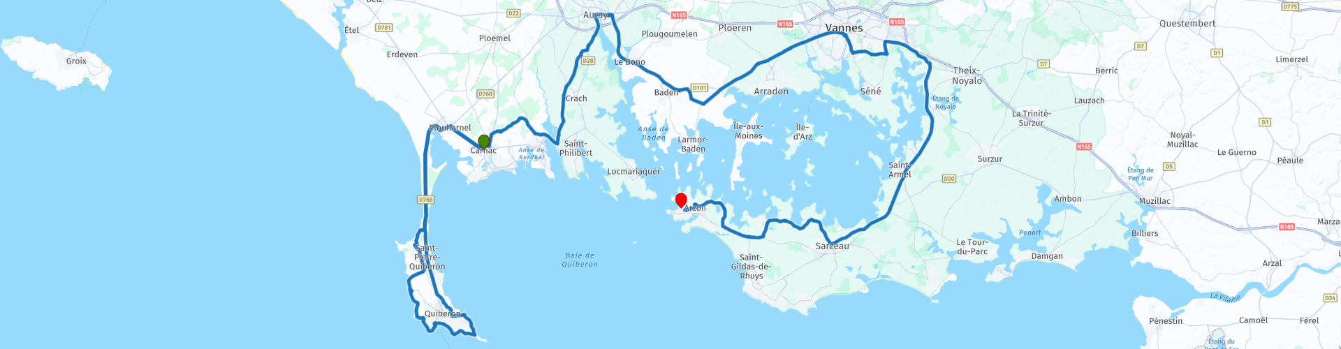
The ride starts in Carnac, a beautiful seaside town with many hotels and a number of campsites for an overnight stay.
We first drive to the peninsula of Quiberon, hereby we drive over a very narrow part where, in strong winds, the waves pop up spectacularly on either side. On this small peninsula there is a lot to see, a number of route points are highlighted below;
RP3; on your right the remains of Fort de Penthièvre, which has been registered as a historic monument since 23 June 19334. In the same year it goes to the navy, but it remains unused.
RP5; beautiful view of the sea.
RP6; Château Turpault on your right.
RP9; here you can park and after a few hundred meters walk to Pointe du Conguel. Here you have a beautiful view of the sea, the islands of Belle-Ile, Houat and Houdic and the lighthouse of la Teignouse.
RP10; the ruins of Fort Neuf on your right.
We leave the peninsula and continue to RP12 the Museum de la Chouannerie. Founded in 1985 and symbolically opened on July 14 by Guy Halna Fretay, the only museum in France dedicated to Chouannerie, Vendée and Western Wars, offers visitors more than 400 pieces (maps, documents, weapons, costumes, various objects, original engravings by Marcel de Villemoisson, etc.), with all the events of the Western wars from 1793 to 1832, of showcases and explanatory paintings. Some prestigious pieces attract the attention of visitors, especially the letters that argue for the eradication of Chouans. These highly moving collections help to better understand what really happened then.
The ride continues to Aulnay and along this route there are many Alignements of Menhirs, some are marked with a route point;
RP13; Alignement du Menec, on a 4 km stretch, it covers almost 3,000 menhirs, with dolmen and burial mounds, hunebeds. These Alignements are all arranged in different long rows, from east to west, depending on the rise and fall of the sun. There are smaller menhirs in the eastern part. And at the end of these long rows, are the largest menhir stones. There is also a kind of hunebed altar in the middle of these high stone blocks.
At RP14 and 15 (a watchtower) you can stop to view the menhirs in the field.
The ride continues to the town of Auray (RP20 and 21) on the Gulf of Morbihan, where we stop for lunch and enjoy the beautiful half-timbered houses.
We then drive to the next beautiful medieval town of Vannes (RP23). It is certainly worth stopping here for a walk through the capital of the Morbihan, which recalls everything about the good life. There are also many (luxury) shops in the center.
We continue the ride to the end point Arzon. The roads are not spectacular, but the many historical sights and beautiful places to stop make this route worthy of 4 stars.


 Links
Links  Usage
Usage Want to download this route?
You can download the route for free without MyRoute-app account. To do so, open the route and click 'save as'. Want to edit this route?
No problem, start by opening the route. Follow the tutorial and create your personal MyRoute-app account. After registration, your trial starts automatically.  Disclaimer
Use of this GPS route is at your own expense and risk. The route has been carefully composed and checked by a MyRoute-app accredited RouteXpert for use on TomTom, Garmin and MyRoute-app Navigation.
Changes may nevertheless have occurred due to changed circumstances, road diversions or seasonal closures. We therefore recommend checking each route before use.
Preferably use the route track in your navigation system. More information about the use of MyRoute-app can be found on the website under 'Community' or 'Academy'.