Roundtrip from Corte to Vescovato through the Castagniccia part 2

This route was brought to you by:
RouteXpert Catherine De Groote RouteXpert
Last edit: 04-12-2022
 Route Summary
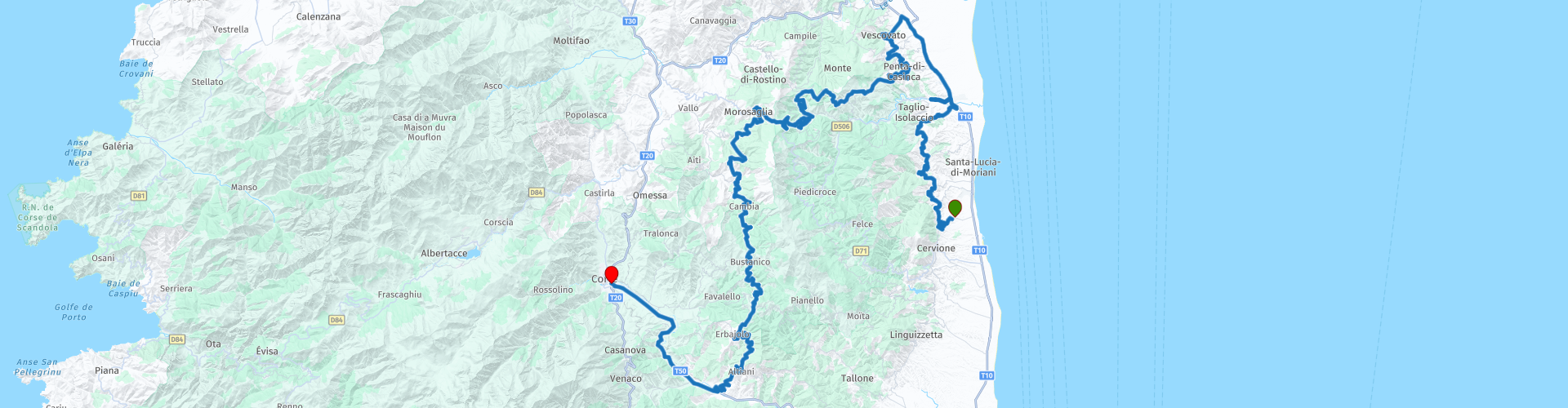
 Exploring Castagniccia is a fascinating experience. There are no autoroutes here, rather a labyrinth of small winding streets winding up and down the hills and past the small villages.
Rather, it is the harmonious whole that has the appeal. Some of the more popular places to visit are Piedicroce, Orezza and the romantic ruins of the Campana Monastery and La Porta. The roads are a fantastic challenge for the motorcyclist. This ride gets 5 stars.
The tour is divided into 2 parts so that you can fully enjoy this beautiful region.
 Share this route


Animation

Verdict


Duration
8h 28m

Mode of travel
Car or motorcycle

Distance
164.05 km

Countries

 RouteXpert Review
 The Corniche de la Castagniccia. The tourist corniche, high above the plain and the sea, follows the narrow D330, carved into the flanks of the mountains. It is one large viewpoint, 5 km long, with several bridges and tunnels along the way. From San-Nicolao the road becomes more difficult to drive on because there is sometimes water and loose gravel on the road.
In Folelli take direction Bastia until the hamlet of Tora. From there you drive to Vescovato, the capital of the Casinca region. It is a place with tall houses of dark schist, streets with steps and a central square with a fountain.
Restaurant A Teppa in Penta-di-Casina offers a beautiful view, you sit comfortably. The restaurant serves pizzas, salads and some main dishes.
Then keep towards Silvareccio, another pretty village on the mountain side. You continue to follow the signs to the Col de St.-Antoine. Watch out: the road gets worse here.
At the top, you can see the remains of the Saint-Antoine Monastery, founded in 1420 in the town of Casabianca. It is a very symbolic place in the history of Corsica. Meetings of the Corsican insurgents of the 18th century were held here. Today it is a ruin, all that remains of the building is the main structure with the bell tower, illustrated with frescoes and decorations that are still clearly visible. The monastery remained famous because in July 1755 Pasquale Paoli was proclaimed commander-in-chief of the Corsican nation. This date marks the beginning of his reign and the beginning of the island's independence, then under the rule of the Republic of Genoa. A commemorative plaque commemorates these events.
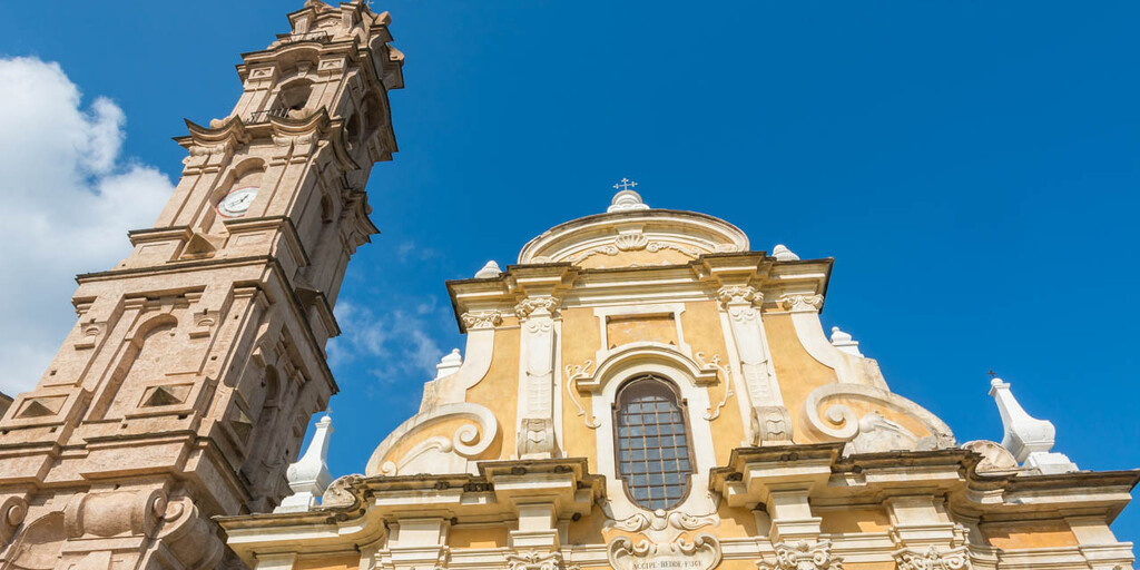
La Porta is located in the heart of the Castaniccia. In the 17th and 18th centuries, La Porta was mainly known for the export of wood, chestnuts and the bark of chestnut trees that were used in the tannery. However, better economic prospects in the coastal cities were a reason for many families to leave in the 19th century. La Porta has never recovered from this exodus, but it is precisely because of this that the atmosphere of historic Corsica has been preserved so well in this village. The Église St.-Jean-Baptiste has a beautiful bell tower 45 m high, a colorful facade and is one of the masterpieces of baroque art in Corsica. The church was completed in 1648 and has been listed as a historical monument since 1975.
In Morosaglia take the hairpin bend to the left towards Gavignano and Saliceto. You are now driving through the Bozio, the roughest area of the island. In San Lorenzo you follow the road to Cambia, Carticasi and Bustanico. Once you get through the hairpin bends, take the road to Sant'Andrea-di-Bozo. Beyond this village the road is very bad, winding and steep for about 1 km.
The road descends to Erbajolo where you have a beautiful view over the valley of the Tavignano, with the Monte d'Oro in the background.
After crossing the Tavignano you get a nice view of the Genoese bridge of Altiani. The bridge with three arches is in Louis XVI style. In order to preserve this heritage and to facilitate traffic, this bridge is no longer accessible to cars since July 2011 and has been replaced by a new bridge.
From here it is about 15 km to Corta, the end of this route.
The citadel of Corta has a rich history and was already transformed into a real fortress in 1419. After many years of different rulers, the citadel became the symbol of Corsica's independence. When the French occupied Corsica in 1769, the citadel became a military site. Now you will find the tourist office, a museum, an art institute and many historical archives. On the upper level is the castle. The Nid d'Aigle is the highest tower and overlooks the valleys of Restonica and Tavignano.

 Links
Links  Usage
Usage Want to download this route?
You can download the route for free without MyRoute-app account. To do so, open the route and click 'save as'. Want to edit this route?
No problem, start by opening the route. Follow the tutorial and create your personal MyRoute-app account. After registration, your trial starts automatically.  Disclaimer
Use of this GPS route is at your own expense and risk. The route has been carefully composed and checked by a MyRoute-app accredited RouteXpert for use on TomTom, Garmin and MyRoute-app Navigation.
Changes may nevertheless have occurred due to changed circumstances, road diversions or seasonal closures. We therefore recommend checking each route before use.
Preferably use the route track in your navigation system. More information about the use of MyRoute-app can be found on the website under 'Community' or 'Academy'.
Corsica
About this region
Corsica (, Upper Corsican: [ˈkorsiɡa], Southern Corsican: [ˈkɔrsika], Italian: [ˈkɔrsika]; French: Corse [kɔʁs] (listen); Ligurian: Còrsega) is an island in the Mediterranean Sea and one of the 18 regions of France. It is the fourth-largest island in the Mediterranean and lies southeast of the French mainland, west of the Italian Peninsula and immediately north of the Italian island of Sardinia, which is the land mass nearest to it. A single chain of mountains makes up two-thirds of the island. In 2018, it had a population of 338,550.
The island is a territorial collectivity of France. The regional capital is Ajaccio. Although the region is divided into two administrative departments, Haute-Corse and Corse-du-Sud, their respective regional and departmental territorial collectivities were merged on 1 January 2018 to form the single territorial collectivity of Corsica. As such, Corsica enjoys a greater degree of autonomy than other French regional collectivities; for example, the Corsican Assembly is permitted to exercise limited executive powers. Corsica's second-largest town is Bastia, the prefecture of Haute-Corse.
Corsica was ruled by the Republic of Genoa from 1284 to 1755, when it seceded to become a self-proclaimed, Italian-speaking Republic. In 1768, Genoa officially ceded it to Louis XV of France as part of a pledge for the debts it had incurred by enlisting France's military help in suppressing the Corsican revolt, and as a result France went on to annex it in 1769. The future Emperor of the French, Napoleon Bonaparte, was a native Corsican, born that same year in Ajaccio: his ancestral home, Maison Bonaparte, is today a visitor attraction and museum. Because of Corsica's historical ties to Tuscany, the island has retained many Italian cultural elements and many Corsican surnames are rooted in the Italian peninsula. Corsican, the native tongue, is recognised as one of France's regional languages. Corsica is the smallest French region by population.
Read more on Wikipedia
The island is a territorial collectivity of France. The regional capital is Ajaccio. Although the region is divided into two administrative departments, Haute-Corse and Corse-du-Sud, their respective regional and departmental territorial collectivities were merged on 1 January 2018 to form the single territorial collectivity of Corsica. As such, Corsica enjoys a greater degree of autonomy than other French regional collectivities; for example, the Corsican Assembly is permitted to exercise limited executive powers. Corsica's second-largest town is Bastia, the prefecture of Haute-Corse.
Corsica was ruled by the Republic of Genoa from 1284 to 1755, when it seceded to become a self-proclaimed, Italian-speaking Republic. In 1768, Genoa officially ceded it to Louis XV of France as part of a pledge for the debts it had incurred by enlisting France's military help in suppressing the Corsican revolt, and as a result France went on to annex it in 1769. The future Emperor of the French, Napoleon Bonaparte, was a native Corsican, born that same year in Ajaccio: his ancestral home, Maison Bonaparte, is today a visitor attraction and museum. Because of Corsica's historical ties to Tuscany, the island has retained many Italian cultural elements and many Corsican surnames are rooted in the Italian peninsula. Corsican, the native tongue, is recognised as one of France's regional languages. Corsica is the smallest French region by population.
View region
 Statistics
  13
13Amount of RX reviews (Corsica)
 17134
17134Amount of visitors (Corsica)
 717
717Amount of downloads (Corsica)
 Route Collections in this region
 The 10 most downloaded routes in France from RouteXpert Hans van de Ven
Hello and welcome to this collection of the Top 10 MyRoute app downloaded routes in France.
There will be a great new event to be announced soon, where all these routes can be driven.
Download them all now and place them in a new "Top 10" folder, so that you always have them at hand.
If you are going to drive one of these routes in the meantime, track them with the MRA Mobile App or with MRA Navigation. Take some photos (moments) along the way as these will come in handy.
Create a travelogue of your Top 10 driven routes and add the recorded track to it.
There will also be some great prizes on offer, so keep an eye on the MRA-RouteXperts page and your mail.
The 10 routes are:
1. Villard de Lans through the wild Vercors
2. Provence Mountains and Lakes
3. From Saint Michel de Maurienne to Barcelonnette South of the Col du Galibier
4. Western Alps from Barcelonnette to St Sauveur sur Tinee
5. R03 Round trip Ribeauville
6. Round trip Appietto Asco Appietto
7. Round trip Appietto Osani Appietto
8. R05 Round trip Urbes
9. R04 Ribeauville to Urbes
10. R02 Wissembourg to Ribeauville
View Route Collection
Discover Corsica in 3 great tours or 6 tours in a row
These tours will introduce you to three regions of Corsica.
The Balagne is a region in northeastern Corsica with a rich history that has developed its own identity over the centuries. The region has long been a prosperous garden of Corsica and proud of its architectural treasures. The Balagne is a world in itself whose breathtaking beauty combines the mountains and the sea with magnificent panoramas, picturesque villages surrounded by fruit trees and vineyards, and idyllic roads in between where you will need all your concentration. But that tension is well worth the Balagna.
The Castagniccia, land of chestnut trees, is the greenest region of Corsica. Very different in character and appearance from the rest, it is a region of small villages and hamlets and steep wooded hills. It still has the charm of authentic Corsica. It is one of the most sparsely populated regions. Exploring Castagniccia is a fascinating experience. There are no autoroutes here, rather a maze of small winding streets that wind up and down the hills and past the small villages. Rather, it is the harmonious whole that has the appeal. The roads are a fantastic challenge for the motorcyclist.
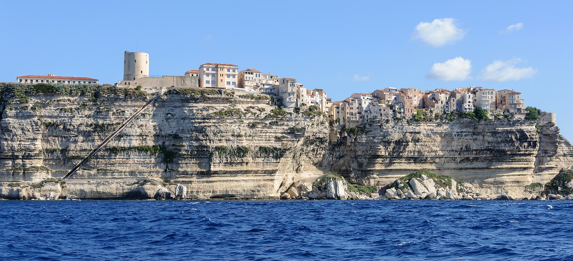
The south of Corsica is the most touristic part of the island. The long beaches with blue-green water, coves and cliffs have been very popular for years. Inland lies the impressive Alta Rocca massif. Here rise the stately 'Aiguilles de Bavella'. Behind Porto-Vecchio is a large forest and rocky area with beautiful views of the sea. Nearby is the Massif de l'Ospédale. Fortified city of Bonifacio has a spectacular location. The prehistoric menhirs of Filitosa are World Heritage. Porto-Vecchio is also called the 'city of salt'. In and around the harbor in the lower town you will find a maze of streets, terraces and shops. Ajaccio is the largest city in Corsica and the capital of the Corse-du-Sud department. The city is also known as the birthplace of the French Emperor Napoleon.
The Balagne is a region in northeastern Corsica with a rich history that has developed its own identity over the centuries. The region has long been a prosperous garden of Corsica and proud of its architectural treasures. The Balagne is a world in itself whose breathtaking beauty combines the mountains and the sea with magnificent panoramas, picturesque villages surrounded by fruit trees and vineyards, and idyllic roads in between where you will need all your concentration. But that tension is well worth the Balagna.
The Castagniccia, land of chestnut trees, is the greenest region of Corsica. Very different in character and appearance from the rest, it is a region of small villages and hamlets and steep wooded hills. It still has the charm of authentic Corsica. It is one of the most sparsely populated regions. Exploring Castagniccia is a fascinating experience. There are no autoroutes here, rather a maze of small winding streets that wind up and down the hills and past the small villages. Rather, it is the harmonious whole that has the appeal. The roads are a fantastic challenge for the motorcyclist.
The south of Corsica is the most touristic part of the island. The long beaches with blue-green water, coves and cliffs have been very popular for years. Inland lies the impressive Alta Rocca massif. Here rise the stately 'Aiguilles de Bavella'. Behind Porto-Vecchio is a large forest and rocky area with beautiful views of the sea. Nearby is the Massif de l'Ospédale. Fortified city of Bonifacio has a spectacular location. The prehistoric menhirs of Filitosa are World Heritage. Porto-Vecchio is also called the 'city of salt'. In and around the harbor in the lower town you will find a maze of streets, terraces and shops. Ajaccio is the largest city in Corsica and the capital of the Corse-du-Sud department. The city is also known as the birthplace of the French Emperor Napoleon.
View Route Collection