Athens to Artificial Lake Doxa

This route was brought to you by:
RouteXpert Yannis Papadiotis
Last edit: 17-11-2024
 Route Summary
 If you are planning to visit this place and need further information's don’t hesitate to contact me.
I award with 4 **** stars this route because of the twisty roads, the beautiful views and the scenic landscape.
 Share this route


Animation

Verdict


Duration
6h 12m

Mode of travel
Car or motorcycle

Distance
194.30 km

Countries

 RouteXpert Review
 It’s a day trip highly recommend to any motorcycle enthusiast looking for a ride through Greece’s diverse landscapes.
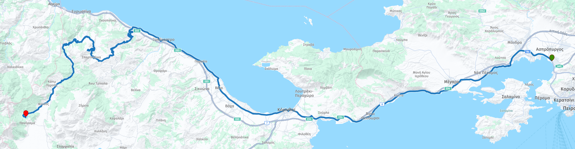
The itinerary starts from Athens with direction to Peloponnesus driving your car or riding your motorcycle from the free of tolls old national road and first stop for a photo is at Corinth canal. The canal is 6.4 Km long and it is completed at 1893, unfortunately doesn’t have the expected traffic due to periodic closures for repairs as well canals narrowness which caused navigational problems.
Next stop is Xylokastro for a short break and energy recovery in front of the sea. Before take the curvy road to Buddhist Retreat Center Karma Berchen Ling consider to refuel with gas in case you ride a motorcycle because in the mountains is difficult to find gas stations.
The Karma Berchen Ling is situated in a region called “The Black Mountains” near the small village of Yelini at 1270 meters high in the beautiful Corinthian highlands with overlooking to the Corinthian gulf.
Before final destination you can had a short stop for a some photos at Evrostina, a place which combines all the colors of nature. Ponds, waterfalls, wooden bridges and oak benches are just some of the elements you can capture around the Mill Stream.
After this place made like in fairy tale we climb the mount Kyllini and its curvy road with a rocks and spruce trees which will drive you at the historic monastery of Agios Georgios, well-known for its fortress-like architectural style and for the traditional spoon sweet made of roses, offered by the monks during your visit which you can buy later if you like.
Taking your panoramic photos then you can move down to the lake Doxa which is a top destination and very popular for a day trip. There is a thin strip of land entering in the lake waters, and on it you will see Agios Fanourios church.
Lake Doxa is undoubtedly the pride and joy of Corinthia’s mountainous area. It’s a picture-perfect lake and it is in perfect harmony with its natural surroundings.


 Links
Links  Usage
Usage Want to download this route?
You can download the route for free without MyRoute-app account. To do so, open the route and click 'save as'. Want to edit this route?
No problem, start by opening the route. Follow the tutorial and create your personal MyRoute-app account. After registration, your trial starts automatically.  Disclaimer
Use of this GPS route is at your own expense and risk. The route has been carefully composed and checked by a MyRoute-app accredited RouteXpert for use on TomTom, Garmin and MyRoute-app Navigation.
Changes may nevertheless have occurred due to changed circumstances, road diversions or seasonal closures. We therefore recommend checking each route before use.
Preferably use the route track in your navigation system. More information about the use of MyRoute-app can be found on the website under 'Community' or 'Academy'.

Attica
About this region
Attica (Greek: Αττική, Ancient Greek Attikḗ or Attikī́, Ancient Greek: [atːikɛ̌ː] or Modern: [atiˈci]), or the Attic peninsula, is an historical region that encompasses the city of Athens, the capital of Greece and its countryside. It is a peninsula projecting into the Aegean Sea, bordering on Boeotia to the north and Megaris to the west. The southern tip of the peninsula, known as Laurion, was an important mining region.
The history of Attica is tightly linked with that of Athens, and specifically the Golden Age of Athens during the classical period. Ancient Attica (Athens city-state) was divided into demoi or municipalities from the reform of Cleisthenes in 508/7 BC, grouped into three zones: urban (astu) in the region of Athens main city and Piraeus (port of Athens), coastal (paralia) along the coastline and inland (mesogeia) in the interior.
The modern administrative region of Attica is more extensive than the historical region and includes Megaris as part of the regional unit West Attica, and the Saronic Islands and Cythera, as well as the municipality of Troizinia on the Peloponnesian mainland, as the regional unit Islands.
Read more on Wikipedia
The history of Attica is tightly linked with that of Athens, and specifically the Golden Age of Athens during the classical period. Ancient Attica (Athens city-state) was divided into demoi or municipalities from the reform of Cleisthenes in 508/7 BC, grouped into three zones: urban (astu) in the region of Athens main city and Piraeus (port of Athens), coastal (paralia) along the coastline and inland (mesogeia) in the interior.
The modern administrative region of Attica is more extensive than the historical region and includes Megaris as part of the regional unit West Attica, and the Saronic Islands and Cythera, as well as the municipality of Troizinia on the Peloponnesian mainland, as the regional unit Islands.
View region
 Statistics
  2
2Amount of RX reviews (Attica)
 99
99Amount of visitors (Attica)
 16
16Amount of downloads (Attica)