IRL Day 7 Killarney national park Healy Pass Priest Leap and Mizen Head

This route was brought to you by:
RouteXpert René Plücken (MRA Master)
Last edit: 19-08-2025
 Route Summary
 The routes take you past the most beautiful towns, villages, sights and wonders of nature.
All routes include waypoints for hotels, restaurants and POIs. The population is very friendly and hospitable, in every village there are several pubs and restaurants where you can enjoy the Irish cuisine.
Several (historical) sights are included in the routes and we try to avoid highways.
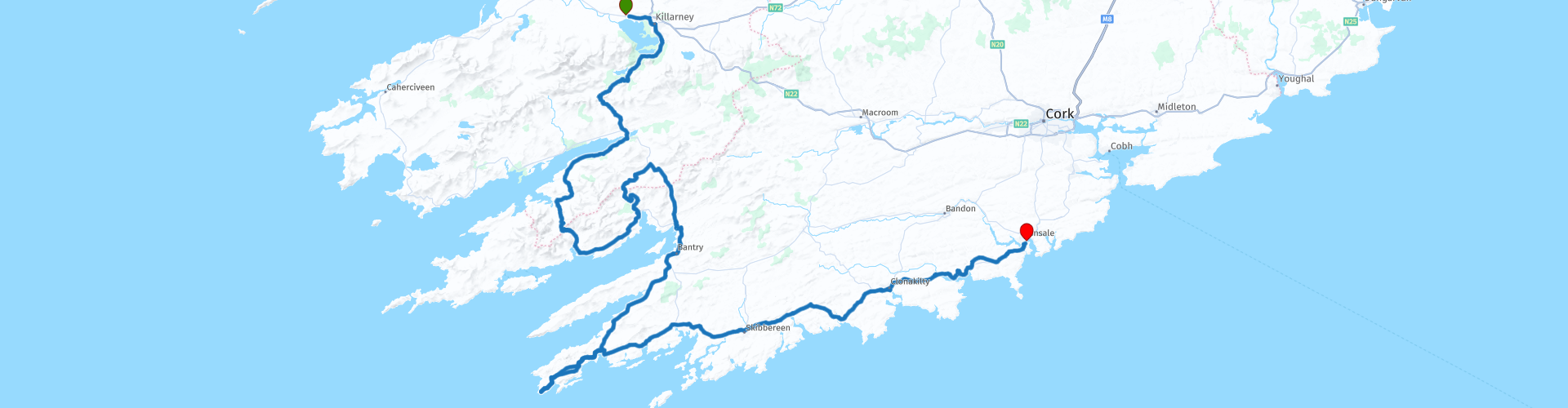
This itinerary covers the seventh day with a beautiful drive through the Killarney National Park, with Molls Gap, Healy Pass, Priest Leap and a visit to the beautiful Mizen Head signal box.
This route has a 5 star rating.
 Share this route


Animation

Verdict


Duration
10h 18m

Mode of travel
Car or motorcycle

Distance
291.42 km

Countries

 RouteXpert Review
 We drive through Molls Gap in the opposite direction as on the previous days, which gives a completely different view of this beautiful pass. Ladies View is definitely worth a stop again, this time in the morning, so also a different view of the most beautiful view of Ireland.
From Kenmare we drive part of the Ring of Beara (see also day 6) to the town of Lauragh where we take the Healy Pass. The Healy Pass is popular with car and motorcycle riders. This road winds through the mountains of Ireland on the Beara Peninsula and offers pure driving pleasure. The road is officially called R574 and runs from the town of Lauragh to Adrigole in County Cork. The name Healy Pass comes from Timothy Michael Healy, who was the first Governor-General of the Irish Free State after Ireland became independent in 1921. He died in 1931, just after the road was renovated. As a tribute, the road was named after him.
After the Healy Pass we follow the coastline to Glengarriff a typical small Irish village in Cork County. We follow the N71 north to Bunane where we follow the signs to Priest's Leap. Priest's Leap is a very winding, narrow and steep mountain pass, consisting of two sometimes unsealed tracks. This road is considered by many to be one of the scariest roads in Ireland and is definitely not for the inexperienced or faint-hearted. So if you are not sure of yourself stay on the N71 and follow the signs to Bantry from Glengarriff.
On your way to Priest's Leap stop at Molly Gallivan's 200 year old Cottage & Traditional Farmhouse, a family run visitor centre. At Molly Gallivan's you will experience the simple lifestyle of rural Ireland before the days of electricity and modern conveniences. Her farm is complete with animals, poultry and traditional farm machinery. On the farm you will also visit the haunting ruins of a family home from the time of the Great Famine and a Neolithic stone row that is part of an ancient solar calendar. Experience 5,000 years of history on a 500 metre walk.
Then the drive over Priest's Leap, a steep and almost single track mountain pass between the villages of Bonane and Coomhola Bridge. It is a winding mountain pass that is not for the faint of heart and as mentioned before is considered by many to be one of the scariest roads in Ireland. It is the highest pass road in Munster at 463m.
The road over Priest's Leap is very narrow, partly on a dirt road with a green strip in the middle and a very steep section north of the summit. There are a few passing places and if there is oncoming traffic you may need to reverse. Priest's Leap is situated in a beautiful, open hilly landscape. The view from the top of the pass is simply breathtaking. Just google it and read the reviews about this stretch of road; you either love it or hate it!
In 1972, the community of Bantry erected a plaque on the rock to commemorate a sacred event. According to legend, a priest was visiting a sick person in the area when Catholicism was banned during the penal period by the British occupiers of Ireland. As pursuing soldiers approached, the priest escaped when his horse made a miraculous leap from the top of the mountain and landed safely near the town of Bantry. At the jump, a rock face left by the horse's hoof print, made by the force of the ascent, can be seen on a rock face. To ensure a safe landing for horse and rider, the rock face they were descending from was turned into soft clay. The prints of the horse's head and knees and the priest's fingers can still be seen on it to this day.
We stop in Bantry, a pretty village with nice pubs and restaurant so ideal to take a break. After Bantry you follow the R591 along the coast with beautiful views over the bay and the peninsulas to Mizen Head.
Mizen Head is a signal post with great views of the rocky coast. You have to walk a bit from the car park. A footbridge takes you to the headland where the signal post is. This is a tourist attraction so it can be busy.
Mizen Head stretches out into the churning Atlantic Ocean, between sea cliffs and crashing waves. But in testament to man’s tenacity, Mizen Head Signal Station has stood strong amidst the forces of nature for over 100 years.
This station was built to warn ships of the treacherous rocks that lie close to the coast here. An award-winning maritime museum has been built near the signal station in honour of the heroic past as a lifesaver at sea.
Perched high on a cliff, the Mizen Head Visitor Centre is a beacon in the darkness. Inside you’ll find exhibits and maritime artefacts including an automatic weather station, a model of Fastnet Rock Lighthouse and a navigation aid simulator, plus a fantastic photographic record of all the wildlife you can find on Mizen Head.
From Mizen Head it continues along the coast through several small villages to Kinsale. Take time to stop along the way and enjoy the views. Visit the West Cork Model Railway Village. The model village is a fully scaled hand-built model of the historic West Cork Railway Line with fully working miniature trains and the towns the railway served in the 1940s.
Kinsale is a pretty town with many hotels, pubs and restaurants on the Bandon River, so a great place to stay.


 Links
Links  Usage
Usage Want to download this route?
You can download the route for free without MyRoute-app account. To do so, open the route and click 'save as'. Want to edit this route?
No problem, start by opening the route. Follow the tutorial and create your personal MyRoute-app account. After registration, your trial starts automatically.  Disclaimer
Use of this GPS route is at your own expense and risk. The route has been carefully composed and checked by a MyRoute-app accredited RouteXpert for use on TomTom, Garmin and MyRoute-app Navigation.
Changes may nevertheless have occurred due to changed circumstances, road diversions or seasonal closures. We therefore recommend checking each route before use.
Preferably use the route track in your navigation system. More information about the use of MyRoute-app can be found on the website under 'Community' or 'Academy'.