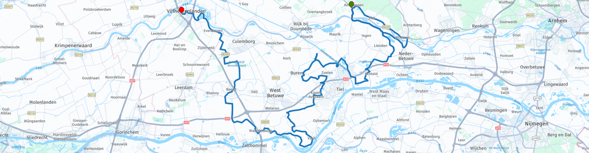
van Amerongen naar Vianen langs de bloesembomen

This route was brought to you by:
RouteXpert Eric Wilderbeek
Last edit: 10-08-2021
 Route Summary
 It is a nice route over nice dyke roads and narrow roads. It is a route that is easy to do for beginners.
You will pass the place Buren where De Prins van Oranje windmill is located. At the Marienwaerdt estate past Beesd you can stretch your legs during a nice walk.
This route gets 4 stars from me because of:
The views are magnificent with vistas as you drive over the dikes. The variation with the color of the fruit trees makes it complete.
The roads are easy to drive and because you drive a lot on narrow roads, it is fun and not too busy.
There is plenty to see along the route and you can stop at several places for photos or a snack.
 Share this route


Animation

Verdict


Duration
5h 21m

Mode of travel
Car or motorcycle

Distance
114.57 km

Countries

 RouteXpert Review
 The start is in Amerongen, where you can start with a good cup of coffee and a piece of apple pie at Herberg Den Rooden Leeuw after your outward journey. If you want to refuel before you start the route, you can do this in Amerongen at the Shell petrol station. You may have to wait a while for your friends and then you can take a walk from the Herberg through the village of Amerongen and perhaps visit Amerongen Castle.
After a short ride we take the ferry across the Lek and from the ferry we go straight onto the dike. Looking out over the farmlands you can see the Utrechtse Heuvelrug and, in season, the blossom trees of the many nurseries along the route.
We drive through the Betuwe and the roads are good and clear. Looking around, we enjoy the river landscape but also the afforestation and of course the beautiful colors of the blossom trees.
From the route you can see the Prins van Oranje windmill near Buren. The Prins van Oranje is a windmill that has been set up as a flour mill. The mill is located on the Molenwal and was built in 1716. The mill also has a small shop where you can of course buy your own ground flour, but also various other traditional delicacies. The mill and mill shop are open every Saturday and Sunday afternoon between 1:00 PM and 5:00 PM.
Just past Kerk Avezaath you can stop at Brasserie NU for lunch. They have parking spaces in front of the door and also sell seasonal products from the region.
After lunch we get on again and drive through the Betuwe towards the Waal. We take a piece of the Waaldijk towards Opijnen and Neerijnen. On the Waaldijk there are benches in several places where you can enjoy the view over the Waal. In Neerrijnen you can visit castle Neerrijnen.
As soon as we have passed under the A2 the route goes north again. At Rumpt we drive over the Linge towards Beesd. Just past Beesd you can stretch your legs during a walk at the Marienwaerdt estate, eat but also spend the night if you perhaps combine this route with other routes through the Betuwe.
We drive past Culemborg and cross the Devendijk in the direction of the Lek. The D Liefdeijk is a transverse dike built in 1284 on the then existing Diefweg. The dike still serves as a full-fledged (second) flood defense that protects the Alblasserwaard and Vijfheerenlanden from flooding from the Betuwe, it is one of the most important inner dikes in the Netherlands. Since January 1, 2019, the Devendijk has been the border between the provinces of Utrecht and Gelderland. Fort Everdingen is located at the end of the Devendijk and you have a beautiful view over the Lek.
Via the Lekdijk we drive to the end point at Hotel van der Valk Vianen. Here you can have something to eat or take the A2 home or to the city of Utrecht to grab a terrace there.


 Links
Links  Usage
Usage Want to download this route?
You can download the route for free without MyRoute-app account. To do so, open the route and click 'save as'. Want to edit this route?
No problem, start by opening the route. Follow the tutorial and create your personal MyRoute-app account. After registration, your trial starts automatically.  Disclaimer
Use of this GPS route is at your own expense and risk. The route has been carefully composed and checked by a MyRoute-app accredited RouteXpert for use on TomTom, Garmin and MyRoute-app Navigation.
Changes may nevertheless have occurred due to changed circumstances, road diversions or seasonal closures. We therefore recommend checking each route before use.
Preferably use the route track in your navigation system. More information about the use of MyRoute-app can be found on the website under 'Community' or 'Academy'.