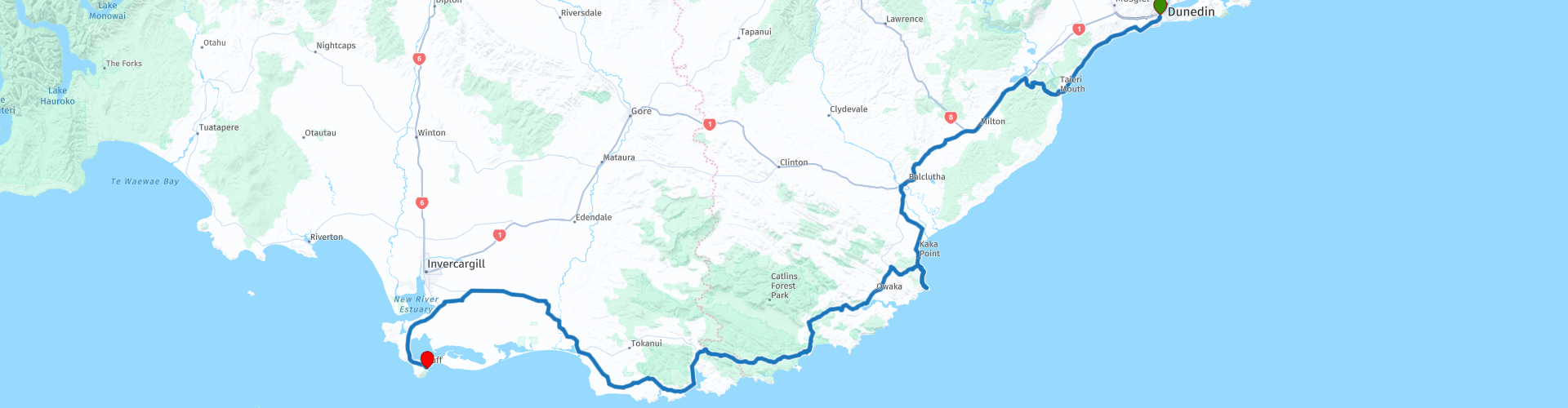
05 Dunedin to Bluff

Diese Route wurde erstellt von:
RouteXpert Nick Carthew - (MRA Master)
Letzte Änderung: 15-04-2021
 Routenzusammenfassung
  Diese Route teilen


Animation

Urteil


Dauer
8h 53m

Reisemodus
Auto oder Motorrad

Entfernung
300.19 km

Länder

 RouteXpert-Überprüfung
 Die Catlins (auch bekannt als Catlins Coast) sind eine abgelegene und unberührte Region im äußersten Süden der Südinsel. Die Region beginnt etwa eine Autostunde südlich von Dunedin zwischen Balclutha und Invercargill / Bluff. Bei den Catlins liegt das Hauptaugenmerk auf der sehr beeindruckenden Natur. Das Klima ist wechselhaft, die Wellen stark und die Küste rau. Wenn Sie die faszinierende Tierwelt Neuseelands erleben möchten, sind die Catlins genau das Richtige für Sie. Hier rollen die lokalen Robben und Seelöwen im Sand und bei Sonnenuntergang watscheln die Pinguine zurück zu ihren Nestern.
Die Catlins befinden sich an der Southern Scenic Route - diese lange Straße, die entlang der Südküste Neuseelands von Dunedin nach Queenstown führt, beherbergt einige der landschaftlich schönsten Highlights des Landes.
Es gibt viele großartige Attraktionen entlang dieser Route, und es kann sein, dass Sie diejenigen auswählen, die Sie besuchen möchten, oder früh abreisen, um sie alle zusammenzudrücken.
Der erste ist der Waihola-See. Dies ist Neuseelands am meisten im Landesinneren gelegener Gezeitensee. Es ist Süßwasser und liegt mehr als 20 km von der Küste bei Taieri Mouth entfernt, mit einer durchschnittlichen Tiefe von weniger als einem Meter. Waihola, was in Maori „sich ausbreitendes Wasser“ bedeutet, ist berühmt für seine schwarzen Schwäne und Reflexionen an einem ruhigen Tag. Ein Besuch im Morgengrauen wird es nur magischer machen und die Chance erhöhen, dass es still ist.
Biegen Sie rechts ab, bevor Sie die Balclutha-Brücke überqueren, um ein Foto zu machen. Die Balclutha-Brücke ist eine der bekanntesten Straßenbrücken auf der Südinsel. Die Brücke wird oft einfach als "The Clutha Bridge" bezeichnet, obwohl es zahlreiche Brücken über den zweitlängsten Fluss des Landes gibt. Diese zwischen 1933 und 1935 erbaute Bowstring-Brücke wurde von WL Newnham als erdbeben- und hochwasserbeständig konzipiert und schützt sie so vor den beiden häufigsten Naturkatastrophen im Süden Neuseelands. Halten Sie auf der anderen Seite für einen Kaffee an, da die Brücke den Beginn der Catlins markiert und es viel zu sehen gibt.
Nugget Point.
Ein Besuch der Catlins wäre nicht vollständig, ohne den Aussichtspunkt und den Leuchtturm am Nugget Point zu sehen.
Der ikonische Nugget Point (oder "The Nuggets", wie von den Einheimischen erwähnt) befindet sich in der Nähe von Kaka Point. Es gibt einen Parkplatz, von dem aus Sie Ihren Spaziergang zum Nugget Point Lighthouse beginnen. Wellenerodierte Felsen, die mit der Form von Goldnuggets verglichen werden, sind von der Aussichtsplattform am Ende des Pfades aus zu sehen. Der Leuchtturm wurde 1869-70 erbaut, ist 9,5 Meter hoch und liegt 76 Meter über dem Meeresspiegel.
Unterwegs können Sie die Robbenkolonie auf den Felsen auf Meereshöhe links vom Pfad und auch unterhalb des Leuchtturms oder die vielen Seevögel sehen, die die Nuggets zu ihrem Zuhause machen. In den Monaten Dezember bis Februar machen Seeelefanten The Nuggets auch zu ihrem Zwischenstopp.
Leichter, leicht bergauf gehender Weg vom Parkplatz zum Leuchtturm - 20 Minuten zurück.
Ich habe eine weitere Kaffeepause in Owaka vorgeschlagen, etwa 20 Minuten von den Nuggets entfernt.
Purakaunui Falls.
Die nächste Attraktion ist Purakaunui Falls. Sie müssen den Scenic Highway für 4 km verlassen und vom Parkplatz sind es nur 5-10 Minuten zu Fuß durch den Wald zu den Purakaunui Falls. Diese kaskadierenden Wasserfälle sind sehr malerisch, mitten in einem Wald gelegen und sollen die am meisten fotografierten Wasserfälle in den Catlins sein.
Kathedralenhöhlen.
Nach einer kurzen Abfahrt von 2 km vom Scenic Highway gelangen Sie zum Parkplatz, um die Cathedral Caves zu besuchen. Diese Höhlen haben aufgrund ihrer Länge internationales Interesse geweckt - die beiden meeresförmigen Passagen messen zusammen 200 m und ihre beeindruckende Höhe beträgt 30 m. Ein 1 km langer Wanderweg führt durch üppige Küstenwälder zum Strand. Es gibt eine kleine Gebühr für die Nutzung des Parkplatzes und den Zugang zum Buschweg, Strand und Höhlen, ca. 1 Stunde Hin- und Rückfahrt. Die Domhöhlen wurden 1896 von Dr. TM Hocken wegen ihrer Ähnlichkeit mit europäischen Kathedralen so benannt. Probieren Sie die Akustik mit einer einfachen Pfeife oder sogar einem Lied aus! Dr. Hocken und seine Freunde taten es und nannten sie Nachhall.
Es wird empfohlen, Ihren Besuch in den Höhlen zu planen. Sie sind nur ungefähr 1 Stunde auf jeder Seite der Ebbe unter sicheren Seebedingungen zugänglich.
McLean Falls.
Der Zugang erfolgt erneut über den Scenic Highway, diesmal rechts. 3 km zum Parkplatz und 20 Minuten zu Fuß zu den Wasserfällen.
Lauschen Sie den einheimischen Vögeln, während Sie durch den wunderschönen Southland-Busch zu einem spektakulären 22-Meter-Wasserfall gehen, der auf beiden Seiten von dunkelgrünen moosigen Felsen umgeben ist. Ein Muss Wasserfall in Neuseeland zu sehen.
Koropuku Falls.
Die reizvollen Koropuku-Wasserfälle sind ein Muss für Fotografen, da sie weit weniger besucht sind als andere, aber leicht zu übersehen sind. Ein kleiner Offroad-Einzug und ein kleines Schild sind alle Hinweise, um diese verborgene Schönheit zu besuchen. Ein mehr oder weniger einfacher Weg beginnt am Parkplatz und führt durch den einheimischen Wald. Die Wende ist sehr gut gepflegt. In 2-5 Minuten nach Beginn des Spaziergangs überqueren Sie einen Bach über eine Fußgängerbrücke und gehen dann entlang des Baches bis zur Basis des Wasserfalls. Die Strecke ist nach Regen rutschig, also bitte vorsichtig sein! Am Ende der Strecke müssen Sie über einige Felsen klettern. Dies ist der schwierigste Teil der Strecke.
Mittagspause.
Ein Zwischenstopp im Niagara Falls Cafe wird Sie nicht enttäuschen, aber ein Blick auf die neuseeländische Version der Niagara Falls kann Sie enttäuschen. Niagara Falls wurde von einem Vermesser mit einem offensichtlichen Sinn für Humor benannt! Die ironisch genannten Wasserfälle haben wenig Ähnlichkeit mit ihrem gigantischen Cousin und sind eigentlich nichts anderes als Stromschnellen. Sie liegen jedoch direkt an einer Hauptstraße, sind leicht zu erreichen und eignen sich perfekt für malerische Fotos und einen Hauch frischer Luft.
Curio Bay.
Eine kurze Fahrt nach dem Mittagessen ist Curio Bay. Die Curio Bay ist von internationaler Bedeutung für ihren versteinerten Wald aus der Jurazeit. Die Baumfossilien, die Sie hier sehen, sind ähnlich wie Kauri und Matai ungefähr 170 Millionen Jahre alt. Der Wald lebte, als Neuseeland Teil von Gondwanaland war. Der versteinerte Wald von Curio Bay lässt sich am besten bei Ebbe von der Aussichtsplattform aus betrachten. Sie können auch durch den Living Forest-Gehweg gehen und sehen, wie der versteinerte Wald vor Millionen von Jahren ausgesehen hat. Dies ist ein besonderes Ereignis auf der Welt, um einen fossilen Wald so nahe an seinem lebenden Gegenstück zu sehen.
Am späten Nachmittag können Sie in der Curio Bay auch geschützte gelbäugige Pinguine sehen, die nach einem Tag auf See an Land gehen.
Steigungspunkt.
Sie verlassen die Straße erneut, wenn Sie Slope Point besuchen möchten. Spektakuläre Ausblicke auf windgepeitschte Bäume, Wellen des südlichen Ozeans, die auf die Felsen krachen, und eine Fotomöglichkeit an einem ikonischen Wegweiser zeichnen diesen südlichsten Punkt der Südinsel aus. Der Parkplatz ist eine 5,5 km lange Umleitung und der Slope Point ist über einen 20-minütigen Spaziergang über privates Ackerland vom Parkplatz aus erreichbar.
Waipapa Point Leuchtturm.
Die letzte Abfahrt vom Scenic Highway ist der Besuch des Waipapa Point Lighthouse. 4 km Schotterstraße, dann 10 Minuten zu Fuß zum Leuchtturm. Am Fuße des Leuchtturms sind oft Seelöwen und Pelzrobben zu sehen. Die Seelöwen veranstalten manchmal eine Show, in der sie untereinander kämpfen. Achten Sie darauf, nicht in die Quere zu kommen!
Bluff.
Die Route führt nun 60 km durch reiches Ackerland bis zum Ende dieser Route am Stirling Point in Bluff.
Als älteste europäische Siedlung Neuseelands hat Bluff eine reiche und abwechslungsreiche Geschichte. Im Schifffahrtsmuseum finden Sie Exponate zu den Themen Walfang, Austernfischen und Schiffswracks. Der Hafen von Bluff ist das Tor zu Stewart Island und die Heimat von Bluff-Austern - die als die besten der Welt gelten. Die Austernsaison dauert von März bis August, und im Mai veranstalten die Einheimischen ein lebhaftes Festival zu Ehren von Ostrea chilensis (lateinisch für Bluff Oyster).
Sie müssen sich in einem der örtlichen Betriebe nach frischen Meeresfrüchten erkundigen - Sie können einfach nichts falsch machen! Gehen Sie durch die Straßen und finden Sie Galerien und große farbenfrohe Wandgemälde in der ganzen Stadt sowie einige bedeutende Denkmäler. Diese charmante Vintage-Stadt steckt voller Überraschungen.
Diese Route endet am Ende des State Highway 1. Der State Highway 1 ist die längste und bedeutendste Straße im neuseeländischen Straßennetz und verläuft auf beiden Hauptinseln 2033 km lang. Machen Sie ein Foto am Wegweiser und finden Sie Ihre Unterkunft wieder in Bluff. Alternativ können Sie weitere 25 Minuten fahren, um in Invercargill anzuhalten. Die nächste Route 06 startet an einer Tankstelle an der North Road, Highway 6 in Invercargill.
Kein Roadtrip-Besuch in Invercargill wäre vollständig ohne einen Besuch der erstklassigen Oldtimer-Displays im Classic Motorcycle Mecca.
Hier sind einige Zeilen aus dem klassischen Motorrad-Mekka:
"Classic Motorcycle Mecca ist Neuseelands führendes Motorradmuseum. Mit einer Sammlung von 1902 bis 2007 haben wir die größte Ausstellung klassischer Motorräder im Land.
In Nelson untergebracht und als NZ Classic Motorcycles bekannt, wurde die gesamte Kollektion im Mai 2016 an Bill Richardson Transport World verkauft. Angesichts unserer natürlichen Begeisterung für Räder und Invercargills gefeierter Besessenheit von Motorrädern bot sich eine einmalige Gelegenheit. Unser brandneues Motorradmuseum, das weithin als Weltklasse-Display angesehen wird, beherbergt über 300 Motorräder und Kunstwerke im Zusammenhang mit Motorrädern - von denen einige genauso wertvoll sind wie die Motorräder! "
Bill Richardson Transport World befindet sich nicht weit östlich von Classic Motorcycle Mecca an der Staatsstraße 1.
Wenn Sie nach Aktivitäten in Invercargill suchen, sollten Sie Bill Richardson Transport World nicht verpassen. Mit buchstäblich Hunderten von ausgestellten Kraftfahrzeugen und Benzinpumpen gibt es viel zu sehen. Transport World ist die größte Privatsammlung ihrer Art weltweit. Entwickelt, um für jeden etwas zu bieten, nicht nur für Fahrzeugbegeisterte.
Links für Bluff-Unterkünfte finden Sie unter dieser Bewertung, einschließlich eines Links für AirBnB, die eine gute Auswahl an abwechslungsreichen Unterkünften haben.
Genießen


 Links
Links  Nutzung
 Möchten Sie diese Route herunterladen?
Sie können die Route ohne MyRoute-App-Konto kostenlos herunterladen. Öffnen Sie dazu die Route und klicken Sie auf 'Speichern unter'. Möchten Sie diese Route bearbeiten?
Kein Problem, starten Sie mit dem Öffnen der Route. Folgen Sie dem Tutorial und erstellen Sie Ihr persönliches MyRoute-App-Konto. Nach der Registrierung startet Ihre Testversion automatisch.  Haftungsausschluss
Die Nutzung dieser GPS-Route erfolgt auf eigene Kosten und Gefahr. Die Route wurde sorgfältig von einem MyRoute-App akkreditierten RouteXpert für die Verwendung mit TomTom, Garmin und MyRoute-App Navigation zusammengestellt und geprüft.
Durch geänderte Umstände, Straßenumleitungen oder saisonale Sperren können sich dennoch Änderungen ergeben haben. Wir empfehlen daher, jede Route vor der Nutzung zu überprüfen.
Verwenden Sie vorzugsweise den Routentrack in Ihrem Navigationssystem. Mehr Informationen zu den Die Nutzung der MyRoute-App finden Sie auf der Website unter 'Community' oder 'Academy'.