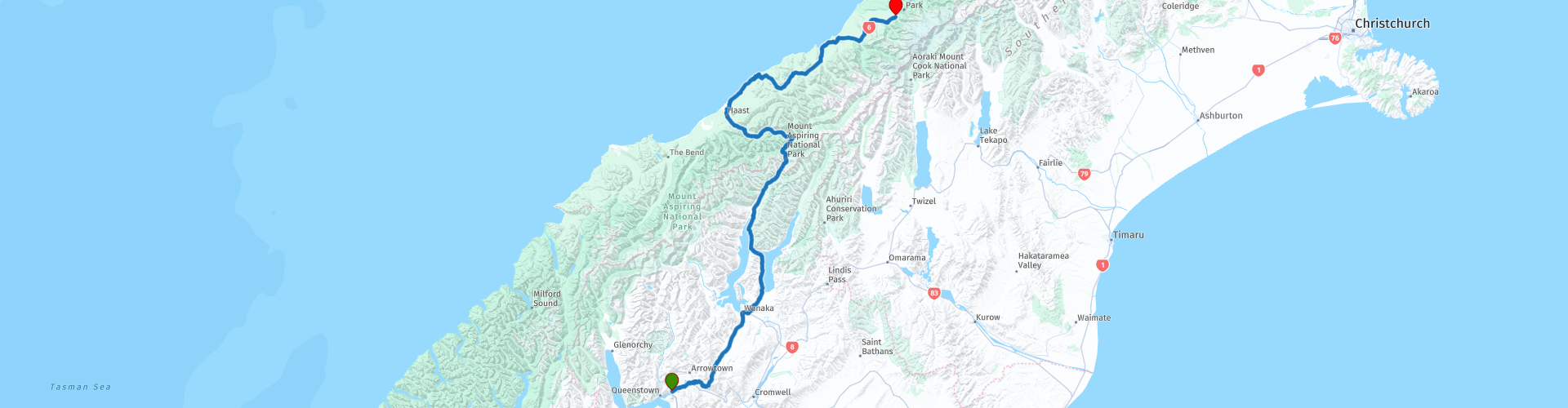
07 Queenstown to Fox Glacier

This route was brought to you by:
RouteXpert Nick Carthew - (MRA Master)
Last edit: 28-04-2021
 Route Summary
 This route travels through the Southern Alps that will surround you all day. It traverses over the highest surfaced road in New Zealand and uses the spectacular Haast Pass to take you to the glacial fields of Mt Cook. The landscapes are breathtaking on very good roads that pass excellent natural attractions. Another 5***** star route on this superb tour.
 Share this route


Animation

Verdict


Duration
9h 11m

Mode of travel
Car or motorcycle

Distance
323.23 km

Countries

 RouteXpert Review
 Starting with a full tank of fuel at Frankton, within 10 minutes of leaving you'll arrive at a superb set of 7 tight hairpin bends that quickly climb 200 m to Arrow Junction Lookout, here you can take some photos of the surrounding panoramic views of mountains, valleys and the hairpin bends.
You will only use one road for the entire day; State Highway 6. This has other local names as it transports you through this beautiful area of South Island. There are two ways to drive between Queenstown and Wanaka, and this one is the most memorable. It's the highest main road in New Zealand. The Crown Range lies between Queenstown and Wanaka. The road over the range, known as the Crown Range Road, is the highest main road in New Zealand. It reaches an altitude of 1076 M, which does bring challenges. In winter, the road is often covered in snow and ice, making for very difficult driving conditions.
Two wheelers should check conditions if you plan on travelling between May and September.
The road climbs steeply to the summit, where you'll be able to see Frankton, part of Lake Wakatipu and Queenstown. On the Wanaka side of the range, the road crosses a plateau of farmland and descends steadily along Cardrona Valley. On the left is the Crown Range; on the right the Criffle Range. This land around here is old gold mining country - piles of tailings can still be seen. The historic Cardrona Hotel is one of New Zealand's oldest - there are many interesting local artefacts on display in the bar and restaurant.
Cardrona also has a distillery and bra fence - yes you read that correctly, a bra fence.
From white lace to leopard print. From 32A to 36DD. You'll find it all at Cardrona's controversial bra fence. It began around 1999, when four bras mysteriously appeared overnight on a fence along the Cardrona Valley Road.
The colourful attraction raised eyebrows among a few stuffy locals but passersby started adding their undergarments to the fence on the way past. It wasn't until an unknown bra thief began cutting them away under the shadow of the night that the fence gained its notoriety. Every time they were cut away, even more were added. The tit for tat (excuse the unintentional pun) continued, garnering media attention, and somewhat ironically, more bras.
The infamous fence was rebranded to "Bradrona" in 2015 to raise money for breast cancer and $30,000 has been raised by people leaving donations in a box at the site.
I have suggested a coffee stop a little further on, on the edge of Lake Wanaka.
The SH6 itself becomes rebranded here to the Haast Pass.
There are some incredible roads to drive in New Zealand, and driving the Haast Pass is one of them. It has everything that makes people fall in love with New Zealand. Rich vegetation, spectacular waterfalls, roaring rivers, mountain views, beach walks, a twisting road, and even a chance to meet some penguins, the Haast Pass is a must drive on any New Zealand itinerary. And with so many stops on the Haast Pass taking less than an hour, you can see and experience so many different things on this route.
The journey from Wanaka to the West Coast passes through spectacular scenery. This route was a traditional pathway for Maori journeying west in search of pounamu (greenstone or jade). The basins that are filled by Lake Hawea and Lake Wanaka were gouged out by the Hawea and Wanaka Glaciers. Two arms of the glaciers joined at a narrow piece of land called The Neck.
Leaving Wanaka, driving to the Haast Pass involves first driving along the massive Lake Hawea. There’s a viewpoint that makes for a nice, short stop with the lake framed by the mountains.
Blue Pools.
Officially, the first stop on the Haast Pass is the Blue Pools. The blue of the water is not to be believed. It’s clear. It’s pure. And the depth of that blue. Completely remarkable. The Blue Pools more than live up to their name. It’s about a 10-minute walk through a forest from the car park to get to the Blue Pools. And parking is directly off the Haast Pass.
Fantail Falls.
The easiest waterfall to get to, Fantail Falls is a nice stop on the Haast Pass. A two-minute walk takes you out of the forest to the banks of the Haast River where you can admire the falls on the other side.
Gates of Haast.
Though a popular stop on the Haast Pass (especially with photographers), the Gates of Haast can be easily missed due to lack of signage. But what are the Gates of Haast? Well, it’s a gorge with falls tumbling over massive boulders. You can view them as you drive over the Gates of Haast, immediately after crossing the bridge, there’s parking on the left side.
Thunder Creek Falls.
Though you get your first glimpse of Thunder Creek Falls while driving the Haast Pass, you cannot miss this stop. A short walk through the forest takes you to an overlook. But, take the few steps down to the beach to get to water’s edge for the best view of these stunning falls. It’s a 96-meter straight drop for the Thunder Creek Falls into the Haast River. Even across the river, expect to feel the mist.
Roaring Billy Falls.
The last big stop on the Haast Pass is Roaring Billy Falls. It’s also the most dramatic of the waterfalls on the Haast Pass. Though not the tallest (just a mere 30-meters), Roaring Billy tumbles over massive boulders. Again, it’s a walk through a stunning forest full of ferns. The entire trek is about a 1 km round trip. At the end of the trail, you can admire the view of the falls, or you can continue closer across the rocks to the river. Either way, it’s still a great view.
I have suggested a lunch stop at Haast, there is a fuel station here too, 200 km from the start.
After lunch you'll reach the west coast and Tasman Sea in 2 km. About 15 km on is Ship Creek Beach. The rugged coast line of the west coast of New Zealand is on full display at Ship Creek. Sand dunes and violently rolling waves make this a spectacular spot. You can enjoy the views of the beach near the car park, or you can opt to do one or both of the short hiking trails here. Both are super easy.
After crossing the Moeraki River, you can choose to turn left to visit Munro Beach.
If you want something truly special, then you must stop at Monro Beach. Here you can witness the Fiordland Crested Penguins (Tawaki) with their distinct yellow plumes. These adorable little guys are endangered, and you must keep your distance from them. But there’s nothing like observing the penguins in the wild in their natural habitat. The best times to view the penguins are from July and November and then January to March.
To get to the beach, you walk through a native New Zealand forest. It’s stunning with its variety of tree ferns. And best of all, the trail is mainly flat. So, anyone can hike it. It’s a delightful walk. Upon reaching the beach, go right until you see a sign by some large rocks. Please don’t go further than these rocks for fear of upsetting the penguins. And, keep in mind, you may be waiting a while before a tawaki appears. From here, you are about 2 hours away from the end of this route at Fox Glacier.
The remainder of the route travels through pristine, native New Zealand forest crossing many glacial fed rivers.
Lake Paringa is worth stopping at for a photo. The distinctive horseshoe shape of Lake Paringa is a reminder of the glacier that once scraped through the landscape. You'll visit the coast again at Bruce Bay where you can see the Rimu rainforest as it meets the sea.
Then onto the suspension bridge that crosses the Karangarua River. With a 130-metre span, it is the longest single-suspension span still in use in New Zealand. In the 1920s most of the rivers south of Franz Josef were not yet bridged, and travel in South Westland was slow and difficult. Over the next two decades a series of single-lane suspension bridges were built, similar in design to this one at the Karangarua River.
The end of the route at Fox Glacier is an ideal place to stop for two nights allowing you to visit both Fox and Franz Josef Glaciers.
While the South Island is full of iconic spots, Fox Glacier is a gem of town tucked away on the West Coast and well worth the visit. Fox Glacier is also one of the only glaciers in the world that descends into rainforest. Fed by four alpine glaciers, Fox Glacier descends 2,600 metres across 13 km. It’s the largest and highest of the West Coast glaciers.
Fox Glacier can be viewed from a lookout on Glacier View Road, but to really take in just how huge this glacier truly it, we recommend driving along Cook Flat Road (on the way to Lake Matheson) where you can see the glacier in all its glory.
If you want to get up close and personal with Fox Glacier, there are Heli-Hikes and scenic flights available that land on the glacier. Either activity is an once-in-a-lifetime experience.
Franz Josef Glacier is just 26 km away along the SH6 through Westland National Park.
Enjoy.


 Links
Links  Usage
Usage Want to download this route?
You can download the route for free without MyRoute-app account. To do so, open the route and click 'save as'. Want to edit this route?
No problem, start by opening the route. Follow the tutorial and create your personal MyRoute-app account. After registration, your trial starts automatically.  Disclaimer
Use of this GPS route is at your own expense and risk. The route has been carefully composed and checked by a MyRoute-app accredited RouteXpert for use on TomTom, Garmin and MyRoute-app Navigation.
Changes may nevertheless have occurred due to changed circumstances, road diversions or seasonal closures. We therefore recommend checking each route before use.
Preferably use the route track in your navigation system. More information about the use of MyRoute-app can be found on the website under 'Community' or 'Academy'.