R02 Angelholm to Alingsas

This route was brought to you by:
RouteXpert Arno van Lochem - Senior RX
Last edit: 20-05-2021
 Route Summary
 The routes are easy for everyone to drive and are on well-paved roads. There may be a single hairpin bend to be taken, but these are easy to do.
If there is a piece of gravel in the route, a warning will be given and a detour will be indicated.
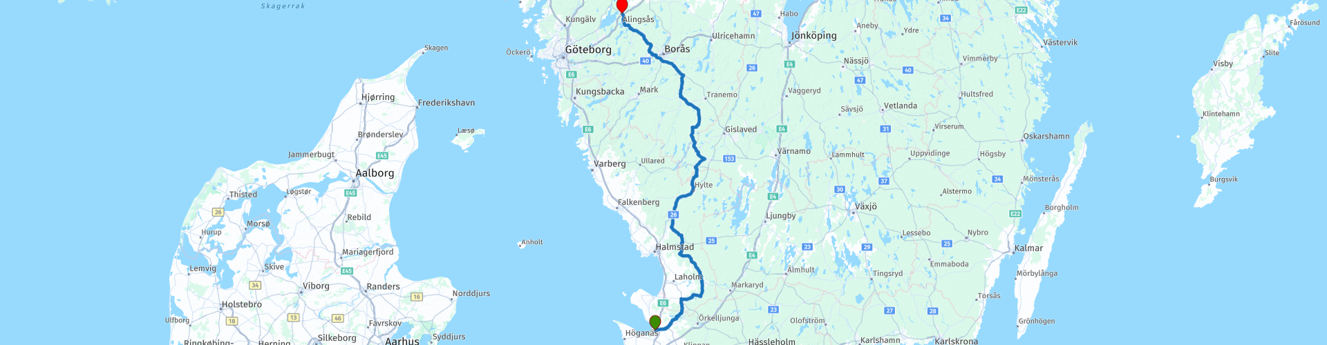
The route takes you through four lån's (provinces), namely Skåne, Hallands, Jönköpings and Vastra Gotalands. You start in Ängelholm and go on large and partly smaller roads to the north. You will pass several lakes where you have to take the time to stop, beautiful and relaxing. The landscape alternates between forest and meadow, where the forest is increasingly gaining the upper hand. You will pass a brewery and a motorcycle museum. The route ends at the Grand Hotel in Alinsås, a nice hotel that can be booked through booking.com.
The camper has also been thought of, there are a number of campsites indicated where you can rent a hiker's cabin or camp.
The route takes you on excellent roads through beautiful forests and along beautiful lakes. The height differences are also getting bigger. In addition, there is plenty to see along the way. For these reasons, I rate this route with 4 stars.
 Share this route


Animation

Verdict


Duration
8h 0m

Mode of travel
Car or motorcycle

Distance
280.97 km

Countries

 RouteXpert Review
 Of all western European countries, the Scandinavian countries probably have the most more or less untouched nature. In addition, they are countries that are easily accessible from the Netherlands. Norway is characterized by, among other things, the fjords and the Trollstigen, known to many motorcyclists. And where Sweden is known as wide and relaxing, everyone knows Finland as the land of 1000 lakes. All in all, legitimate reasons to traverse this beautiful nature in the north of Europe by means of a number of routes.
The route starts in Ängelholm, located in the south of Sweden. Soon you will leave this place behind to buy some food and drinks for the road in Munka-Lhungby at the local supermarket. You can also fill up the tank at the gas station if necessary.
After any necessary shopping for the road, the route really starts. After about 20 kilometers you will see the first of the many lakes that you will pass today. One even more beautiful and bigger than the other. This lake is the Rössjön and has an area of 3.5 square kilometers. The lake is part of the Rönne basin. Nice place to stop for a photo.
A little further in the route you will see another lake on the right, Oxhultasjön. That is a lake through which the river Smedjeån flows. You may not expect it, but this lake is just under 3 meters deep. With an area of 1.6 square kilometers, it forms an important part of the Lagan catchment area.
The lake is known for its unspoilt nature with a rich bird life, you will encounter cranes and geese.
Just after this lake there is some disagreement between TomTom and Garmin at the intersection. TomTom lets you drive straight ahead, then you have to turn in an almost impossible way. Garmin just sends you to the left and that is allowed and possible.
Just behind the town of Knäred you will pass the Brovikens Brewery. This is one of the smallest brewery museums in the south of Sweden. The brewery was founded by Ivar Larsson in 1926 near a small bulge of the Krokån, roughly where the bridge crosses Sjöaredsvägen. Two years later, Johan Svensson from Mörkhult takes over the company and it remains within the family until the closure in 1975. Really nice to have a look here.
You will also find Prästaskogen close to the museum. The nature reserve with the new suspension bridge over der Krokån is a place that gets a lot of attention for its beauty, the landscape, the nearly five-meter-high waterfalls of the river and the sweeping progression of the water that has been cutting stones for millennia. It is wonderful to see how the water manages to find a path between and over the stones, forming a spectacular spectacle.
About ten kilometers further you can stop at a beautiful nature reserve, the Mätocka Heide. A visit to this area is a journey through time. You get an idea how magnificent, desolate and yet beautiful the former Halland heath once was. If you are lucky you can hear the black grouse playing on an early spring morning. The heathland covers an area of 156 hectares and has been protected since 1978. Really stop and enjoy the view over the lake after a short walk of 200 meters!
The route winds further through endless forests and along seemingly countless lakes. Before you know it, you'll cross the lån border and enter Västra Götalands. Not that it will be anything else, the forests and the lakes still look the same.
Ten kilometers after the refueling stop you will again pass a large lake, Visen. This is a lake that is part of the Ätran basin. The lake is 32.5 meters deep and has an area of over 182 square kilometers. Nice place to stop, stretch your legs and take a picture.
Just before Svenljunga you come to the exit to the Bynanders Motor Museum. That is a museum with about 66 cars and more than 200 mopeds and motorcycles, radios and a collection from an old country store. There is a cafeteria here where you can get some simple dishes, both food and drink.
If you don't visit the museum, you can stop in the center of Svenljunga at Ewas Cafe for a cup of coffee.
After coffee you will arrive after 15 kilometers on the 27, which runs to today's final destination, Alingsås. But before you get there you will find Älmås Nature Reserve on the right. It is 35 hectares and has been protected since 2006.
Piles and stone walls line old fields and meadows. Old deciduous trees such as elm, ash, hornbeam, beech, oak, birdberry, linden and maple grow between the fields. The area bears traces of older agricultural landscapes with fossil arable land and house foundations. Over the years, the open areas have been reduced in size and replaced by groves and forests. Plants found include horseradish, thyme, bellflower, hay bale and stag beetle. Lichens and mosses that deserve protection grow on the old trees. Lung lichens, elm lichens, and goldencap moss are some of the species found in the reserve. The fungi cinnabar tick and chanterelle mussel are common.
The route runs through the nature reserve, the road consists of two lanes of gravel. If you don't feel like doing this, keep following the 27, more than 800 meters further you drive on the route again.
As soon as you enter Alingsås there is one last opportunity to enjoy one last lake called Gerdsken. Walking up a scaffold between the trees and contemplating the 'skyline' of the place where you are going to spend the night is worth a photo.
Three kilometers further you will arrive at the overnight address, which is also the end point of the route, Grand Hotel Alinsås. For campers there are two campsites in the area marked as POIs: Lövekulle camping and Lygnareds Camping.
Have fun driving this route!


 Links
Links  Usage
Usage Want to download this route?
You can download the route for free without MyRoute-app account. To do so, open the route and click 'save as'. Want to edit this route?
No problem, start by opening the route. Follow the tutorial and create your personal MyRoute-app account. After registration, your trial starts automatically.  Disclaimer
Use of this GPS route is at your own expense and risk. The route has been carefully composed and checked by a MyRoute-app accredited RouteXpert for use on TomTom, Garmin and MyRoute-app Navigation.
Changes may nevertheless have occurred due to changed circumstances, road diversions or seasonal closures. We therefore recommend checking each route before use.
Preferably use the route track in your navigation system. More information about the use of MyRoute-app can be found on the website under 'Community' or 'Academy'.