Fort Collins Walden

This route was brought to you by:
RouteXpert René Plücken (MRA Master)
Last edit: 16-12-2025
 Route Summary
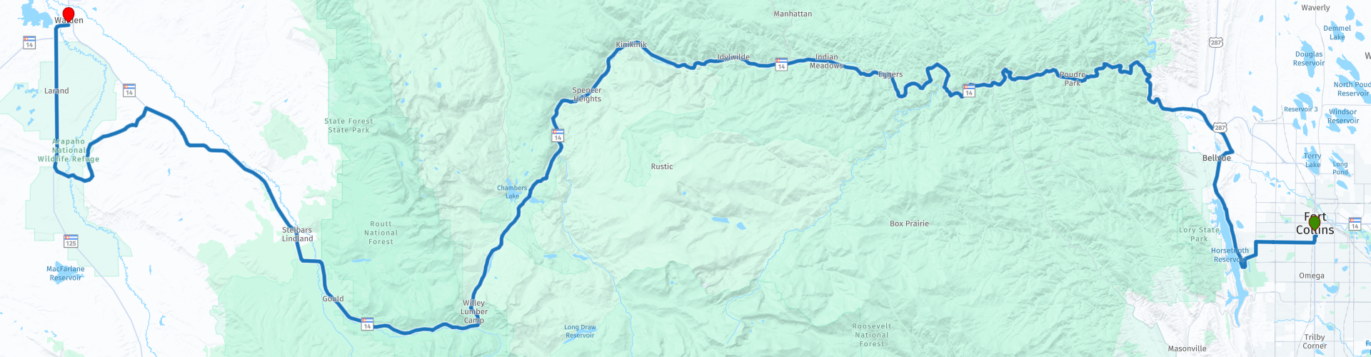
 This review describes the Cache La Poudre Scenic Byway through this beautiful nature park.
Along the way you can enjoy the beautiful nature with lots of cattle and also wildlife.
The route runs from Fort Collins through the Rocky Mountains to the town of Walden.
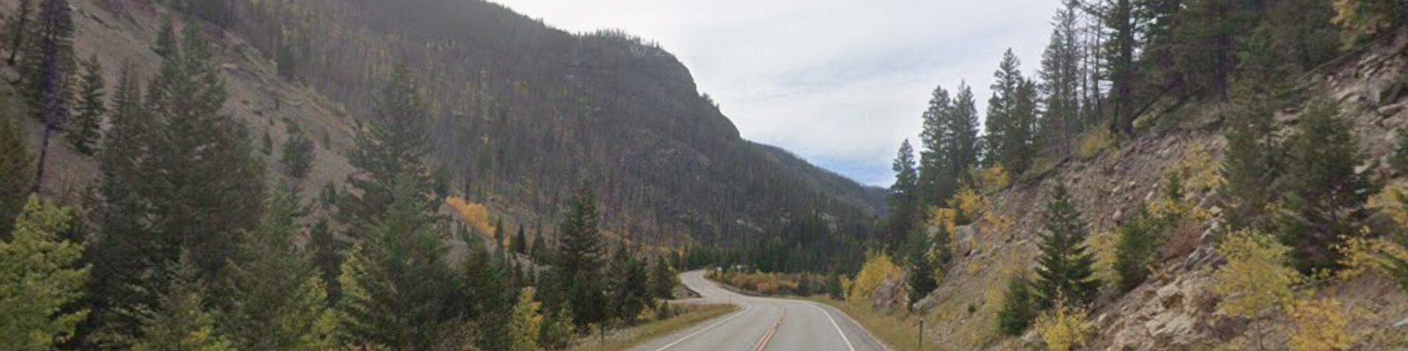
This route, with its beautiful roads through the gorges along the river interspersed with stunning greenery, deserves a 4-star rating. There aren't many attractions along the route itself, but there are several places to stop for a picnic, fishing, rafting, canoeing, or kayaking.
 Share this route


Animation

Verdict


Duration
6h 48m

Mode of travel
Car or motorcycle

Distance
185.12 km

Countries

 RouteXpert Review
 The North Park area was once home to thousands of bison that roamed the plains. Today, you'll mainly see deer, antelope, elk, beavers, and coyotes. The Cache la Poudre is now intensively managed for water management in the region. The Scenic Cache la Poudre Byway begins in Fort Collins and takes you through the Roosevelt National Forest, along the Poudre River, through Poudre Canyon to Cameron Pass, and then down to North Park.
Fishing enthusiasts are well advised to bring their gear. The clear river is easily accessible, and along the banks there are ample opportunities for trout fishing in the eddies and reservoirs, often just a short distance from the side roads.
There are also several places where you can rent a raft, canoe, or kayak to explore the river, such as the Gateway Natural Area. This is a popular spot to enjoy peace and quiet, perfect for a picnic. The city's old water filtration plant is also located here, where the North Fork of the Poudre River meets the main branch.
Another option for lunch is the Mishawaka Amphitheater, a single-stage outdoor concert venue located about 25 miles northwest of Fort Collins along Colorado State Highway 14. The complex sits directly on the banks of the Poudre River. The restaurant, with its beautiful outdoor seating, is open year-round, and the amphitheater is accessible from May through September.
We'll visit Arrowhead Lodge, originally built as a summer mountain resort. Construction began in 1933, and the lodge opened in 1935. In 1984, Arrowhead Lodge was transferred from private to public ownership through a land exchange and became the property of the US Forest Service. Today, the lodge serves as a visitor center for travelers and recreationists in the Cache la Poudre River Corridor. The staff is available to answer questions and sell forest maps and federal recreation passes. The lodge is also known as a viewing point for bighorn sheep, which can often be seen on the slopes behind the main buildings.
We drive over the impressive Cameron Pass, a mountain pass at 3,132 meters in north-central Colorado, located in the Rocky Mountains. The pass connects the south side of the Medicine Bow Mountains with the north side of the Never Summer Mountains. It lies on the border of Jackson County and Larimer County, approximately three miles north of Rocky Mountain National Park. Cameron Pass is the most direct and optimal route between Fort Collins and Walden in North Park, via State Highway 14.
As you drive the Cache la Poudre Byway, you can admire unique geological formations created by earthquakes and tectonic movements millions of years ago, such as the striking peaks of Nokhu Crags (Eagles Nest), which reach a height of 3,807 meters.
We'll also visit the Moose Visitor Center, operated by Colorado State Forest State Park and located near Gould's former logging camp. The center tells the story of the moose in North Park and the former logging camps, and also provides information about the park and its wildlife.
As we approach Walden, the Medicine Bow Mountain Range in Wyoming is visible in the distance from the Cache la Poudre Byway. Just past Walden, it's definitely worth visiting the Arapahoe National Wildlife Refuge. This nature reserve is a popular birdwatching spot. It was established to create breeding and habitat for migratory birds. Here you can observe Wilson's phalarope, black-winged avocets, willets, sandpipers, yellowlegs, dowitchers, sage grouse, golden eagles, and hawks, among others. After this final stop, we continue to the hotel in Walden.
Outdoor enthusiasts might consider planning a longer stay in this region to visit the Rawah Wilderness Area. This 120-acre (309.16 km²) area features U-shaped, glacier-carved valleys and peaks. Meltwater has created 26 lakes here, teeming with rainbow and brook trout. More than 75 miles (120 kilometers) of trails provide access to activities such as hiking, horseback riding, and cycling. In the fall, many hunters visit the area for deer and elk hunting. You can also enjoy numerous other activities, such as backpacking, climbing, kayaking, canoeing, rafting, horseback riding, birdwatching, and stargazing.
Even in winter, there's plenty of recreation to be had in the high country. Many Forest Service roads and trails are transformed into paradises for snowmobiling and cross-country skiing.


 Links
Links  Usage
Usage Want to download this route?
You can download the route for free without MyRoute-app account. To do so, open the route and click 'save as'. Want to edit this route?
No problem, start by opening the route. Follow the tutorial and create your personal MyRoute-app account. After registration, your trial starts automatically.  Disclaimer
Use of this GPS route is at your own expense and risk. The route has been carefully composed and checked by a MyRoute-app accredited RouteXpert for use on TomTom, Garmin and MyRoute-app Navigation.
Changes may nevertheless have occurred due to changed circumstances, road diversions or seasonal closures. We therefore recommend checking each route before use.
Preferably use the route track in your navigation system. More information about the use of MyRoute-app can be found on the website under 'Community' or 'Academy'.