Via Podensis from Senergues

This route was brought to you by:
RouteXpert Jan Koelstra - Senior Rx
Last edit: 24-12-2024
 Route Summary
 Classified as European cultural heritage, the route stretches from the volcanic landscape of the Haute Loire to the foot of the Pyrenees in the French Basque Country. The motorised version is no less impressive, as you will discover.
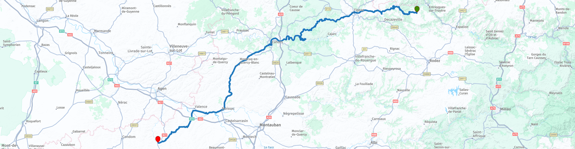
This trip follows the route between Sénergues and Lectoure.
Today, the Via Podensis is best known for the beautiful nature you ride through. This and the medieval towns and villages with beautiful monuments you pass, earns a maximum rating of five stars.
 Share this route


Animation

Verdict


Duration
9h 8m

Mode of travel
Car or motorcycle

Distance
257.32 km

Countries

 RouteXpert Review
 In the Middle Ages, many pilgrims traveled along several well-trodden (but not always easy or safe) routes to the pilgrimage site of Santiago de Compostela, located in the northwestern corner of Spain. This city boasted of having the body of Saint James in its possession. The pilgrimage route through northern Spain formed a single line. Prior to that route, four major routes ran through France.
One of these supply routes starts from the Massif Central in France and runs through the Pyrenees to the Spanish border. This route is called the Via Podiensis and is 740 km long. The Via Podiensis passes through several southern French centres of great religious importance, such as Le Puy, Conques, Cahors, Moissac and Saint-Jean-Pied-de-Port.
In terms of landscape, it is a very varied route, which partly leads through gorge valleys (such as the Allier or Célé valley). It is a winding route, so you will not cover many kilometres per day. If you only do the part to Moissac, you will pass through the main religious sites. The last part leads through the plains located south of the Garonne and through the beginning of the Pyrenees. In terms of distance, you can roughly divide this route into three equal parts.
The second section, this one, runs from Sénergues to Lectoure.
The church of Sérnergues is the most important historical monument in the centre of the village. At the back of the church is a square stone tower, dating from the end of the 14th century. Its main attraction is the panoramic view over the village and the pilgrimage route to Santiago de Compostela. A nice stopover just a stone's throw from the beautiful city of Conques.
A pilgrimage to the tomb of Saint James did not necessarily always follow the shortest route. The places visited along the way depended on their religious importance. Conques had a great religious influence with the relics of Sainte Foy. Many pilgrims visited the monastery of Conques from the 10th century onwards. The 12th-century arched field in the portal of the cathedral will probably have been paid for by the many donations. The Last Judgement is depicted in this tympanum, with heavenly joys to the right of Christ and hellish misery to the left. In the outbuildings of the cathedral of Conques, a precious church treasure is exhibited under a barrel vault. The relic statue of Ste.-Foy displayed here is a rare piece of wire gold and precious stones (10th century).
Figeac is authentic because a relatively large part of the old buildings has been preserved, the city has many old monuments. Figeac was namely a prosperous merchant city on the major pilgrim routes. The rich merchants had the workshop / warehouse on the ground floor, at the front the arcades with the shop window. The living space was on the first floor and can be reached via a narrow spiral staircase. The attics were usually drying attics, for drying fruit, dyed fabrics and the like.
The Place des Écritures is notable for its enormous image of the Rosetta Stone, made of black granite, in honour of Jean François Champollion. He became famous for deciphering the Rosetta Stone, and thus for starting the deciphering of Egyptian hieroglyphics. There is also a Champollion museum in the town.
The next place you come across is Marcilhac-sur-Célé. An abbey was established on this spot on the Célé as early as the 9th century. Now, like the other villages on the romantic Célé bank, it is a meditative resting place. The monastery has a somewhat weathered portal with a Last Judgement. In the chapter house, you will notice various capitals with monsters, devils and biblical scenes. Northwest of Marcilhac, a small road climbs up to the Grotte Bellevue (dripstone formations).
Cabrerets is a charming village situated at the confluence of the Sagne and the Célé, dominated by a castle. The very romantic ruins, clinging to the cliff, are one of the oldest constructions from the Lot Middle Ages.
Just past Cabrerets there is also an underground world, the Grotte du Pech-Merle. Since the closure of the famous Lascaux cave, Pech-Merle is one of the most impressive caves with prehistoric paintings. A museum at the cave will show you around in advance. This will give you a good impression of the artistic world of painted mammoths and horses, art of a respectable age of 20,000 to 40,000 years. The most important painting is a panel from 18,000 BC with two horses and six black hands.
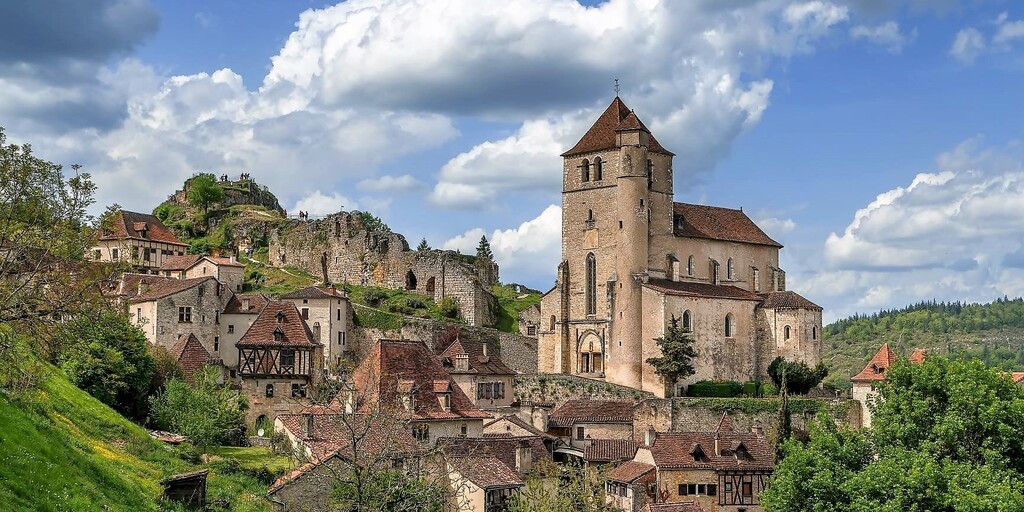
The planned lunch stop is in the most beautiful village in France, Saint-Cirq-Lapopie. Of course, it also belongs to the heritage list: "Les plus beaux villages de France: the most beautiful villages in France". It can therefore be quite busy. Nevertheless, it is very special to walk through it. The pointed roofs and pink facades rise at the foot of a fortified 15th century church, flanked by a staircase turret and a square keep. At the very bottom you will find a network of steep streets. You can also admire cantilevered facades, some with wooden panels, gardens, galleries, cross windows and shop arches. If it is far too busy for lunch, you can also do so in the next town.
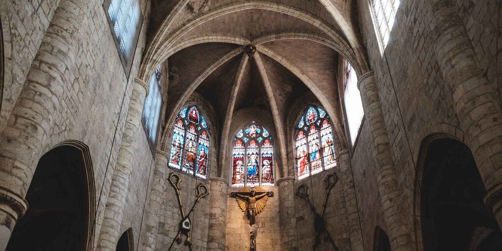
Cahors, a little further on, is known for its dark wine, its gastronomy and its markets, and enjoyed commercial prosperity until the Hundred Years' War, when the English and French turned the area around Cahors into a battlefield. The centre of Cahors is caught in a hairpin bend in the Lot. On the west side, a magnificent fortified bridge connects the river banks. This Pont Valentré is made up of seven pointed arches and crenellated breakers. Three sturdy towers climb up from the bridge. On the other side of the city, the domed church of Cahors stands out. Of the three domes, two remain. The third has collapsed and has been replaced by a Gothic choir.
Then, get lost in the medieval alleys of the old town, and discover the mysterious and enchanting Cahors. Experience the splendor of the sumptuous houses, the charm of the squares and the ingenuity of the Jardins Secrets that color the city. In the shade of the plane trees, enjoy the lively Gambetta boulevard, a 19th century heritage.
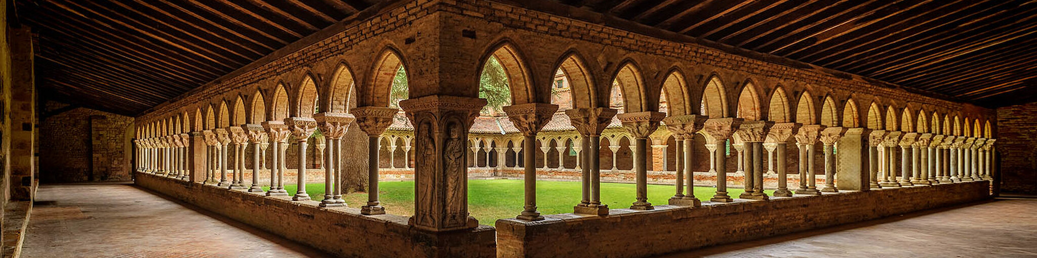
Between the 7th and 10th century, the Moissac Abbey did not have many (pilgrims) visitors. That would change after the abbey joined forces with Cluny in 1047, a powerful Benedictine abbey at the time. In the current brick-built town, the abbey's sculptures are now a gem of Romanesque sculpture. The church itself is less important than the only 11th-century part that remains, the massive bell tower with the much-visited portal. The tympanum is considered a masterpiece and has been chiselled in a very original way. In the cloister courtyard you will encounter a second surprise. No fewer than 88 carved capitals can be admired there. These did not survive the French Revolution entirely unscathed (iconoclasm).
The last part is over the local narrow roads to Lectoure. The town was built on a limestone rock above the river Gers and was therefore easy to defend. From this the Roman town of Lactoratus grew from the 2nd century BC. The Roman town itself was more in the plain at a crossroads of roads and was easily accessible for trade. Also over the Gers goods could be transported to the Garonne in the good seasons. After the fall of the Roman Empire the buildings moved more towards the safety of the rock. The town became a bishop's seat and got city walls; the castle dates from the 14th century. There were monasteries of Poor Clares, Carmelites and Capuchins. Tourism is currently an important source of income for Lectoure.
 Links
Links  Usage
Usage Want to download this route?
You can download the route for free without MyRoute-app account. To do so, open the route and click 'save as'. Want to edit this route?
No problem, start by opening the route. Follow the tutorial and create your personal MyRoute-app account. After registration, your trial starts automatically.  Disclaimer
Use of this GPS route is at your own expense and risk. The route has been carefully composed and checked by a MyRoute-app accredited RouteXpert for use on TomTom, Garmin and MyRoute-app Navigation.
Changes may nevertheless have occurred due to changed circumstances, road diversions or seasonal closures. We therefore recommend checking each route before use.
Preferably use the route track in your navigation system. More information about the use of MyRoute-app can be found on the website under 'Community' or 'Academy'.

Occitanie
About this region
Occitanie (French pronunciation: [ɔksitani] (listen); Occitan: Occitània [utsiˈtanjɔ]; Catalan: Occitània [uksiˈtaniə]), Occitany or Occitania (), is the southernmost administrative region of metropolitan France excluding Corsica, created on 1 January 2016 from the former regions of Languedoc-Roussillon and Midi-Pyrénées. The Council of State approved Occitanie as the new name of the region on 28 September 2016, coming into effect on 30 September 2016.The modern administrative region is named after the larger cultural and historical region of Occitania, which corresponds with the southern third of France. The region Occitanie as it is today covers a territory similar to that ruled by the Counts of Toulouse in the 12th and 13th centuries. The banner of arms of the Counts of Toulouse, known colloquially as the Occitan cross, is used by the modern region and is also a popular cultural symbol. In 2015, Occitanie had a population of 5,839,867.
Read more on Wikipedia
View region
 Statistics
  81
81Amount of RX reviews (Occitanie)
 30447
30447Amount of visitors (Occitanie)
 4256
4256Amount of downloads (Occitanie)
 Route Collections in this region
 25 Magnificent trails in France
This MRA route collection contains 25 beautiful motorcycle routes in different parts of France, such as the Ardennes, the Alsace, Vercors, the Drôme, the Ardèche, Cote d'Azure, Gorges du Verdon, the Ariège, the Dordogne and Brittany.
The routes have been carefully created by Bert Loorbach, who is an enthusiastic motorcyclist himself. He lived in France for a year and a half, during which time he devoted himself to mapping the unknown and beautiful back roads of France especially for motorcyclists.
The routes are bundled in the Motortourgids France part 1 of Kosmos publishing house and now also available in MyRouteApp.
I have taken over the routes in MRA and sometimes adjusted them slightly to make them even more interesting for the motorcyclist.
View Route Collection
24 Magnificent trails in France
It is clear that France is one of the most beautiful and best touring countries. It offers an incredibly varied landscape with good roads and a pleasant climate. It is not for nothing that you see so many motorcyclists there. My previous collection of 25 routes in France (25 Magnificent routes in France) were based on the route descriptions from the Motortourgids France part 1 made by Bert Loorbach.
This collection of 24 routes comes from Motortourgids France part 2. In this collection, a difference has been made between approach routes and motorcycle tours in a certain area. The approach routes can also be used in combination with the routes from Motortourgids France part 1
The routes are sometimes slightly adjusted based on the tips that Bert Loorbach gives in his description, or because of another place to spend the night, or to reach the minimum length of 2 hours for the MRA Library. For each route, the review contains a more detailed description, including options to stay overnight or places of interest along the way, which are also indicated with a POI and if possible with a short description.
Two or more routes have been created for a number of areas, such as for Burgundy, Auvergne, The Alps, Tarn and Cévennes and Nord-Pas de Calais. These routes can be nicely combined in a multi-day trip.
View Route Collection