Cathar Castle Country South Loop 2

This route was brought to you by:
RouteXpert Steve Montreal
Last edit: 22-01-2025
 Route Summary
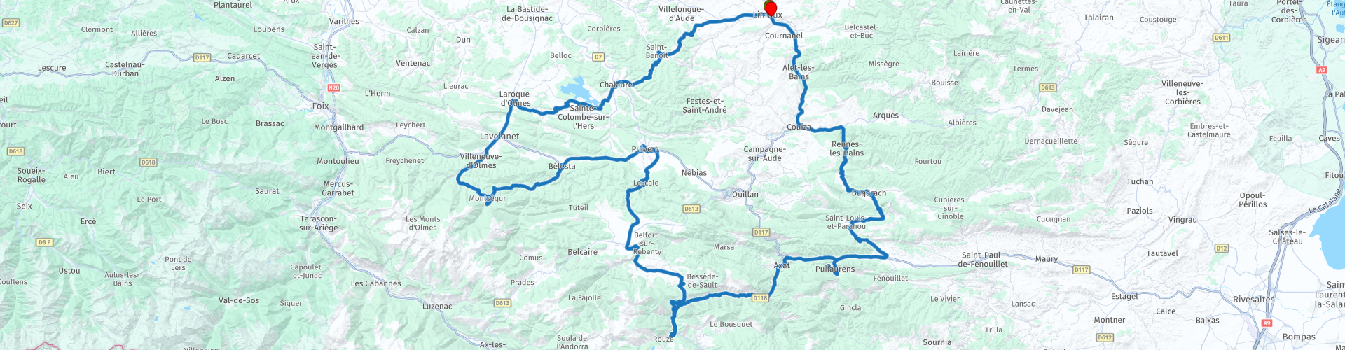
 The route takes in probably the most well known of the Cathar Castles, Chateau Montsegur, with its brutal history.
At all of the attractions, you can take the time for a tour, or just stop briefly to admire the fortifications from below.
Either way you will have an interesting day out.
There are many other highlights along the way, from geological wonders, the beautiful scenery in the Roussillon and Corbieres + many miles of empty challenging roads to ride.
I give this route 4* due to a nice mix of enjoyable riding, the ancient and modern history & beautiful scenery of Occitania.
 Share this route


Animation

Verdict


Duration
10h 2m

Mode of travel
Car or motorcycle

Distance
213.81 km

Countries

 RouteXpert Review
 They called themselves Good Men and Good Women.
History named them Cathars to define the followers of this new belief that took a strong hold in the South of France from the 12th century.
Catharism emerged in a context where the Church had become rich and powerful but was targeted by a succession of militant movements by dissidents demanding a return to the ideals of poverty.
It was their dualism, their belief that the pleasures of the flesh were the work of the Devil, that opposed the Cathars to the Catholics.
They lived by their own rules and recognised only one sacrament, the consolamentum, which replaced the rituals of marriage, extreme unction and baptism.
While it was a Catholic movement, Catharism was quickly considered to be heretic by the Pope of the era.
He launched the “Albi Crusade” in opposition of the movement.
The “Holy War” of the Crusade gradually turned into a full-scale geopolitical battle serving the interests of the King of France.
Some of the previously seigniorial castles became sanctuaries for the Cathar peoples.
Seized by the King, they were transformed into proper military fortresses whose role was to protect the French border from the kingdom of Aragon.
In this relentless fight, the abbeys rallied behind the Catholic Church.
One by one, the castles fell to the hands of the King’s lords.
The Good Men and Good Women had no choice but to flee.
Later, the Crusade gave way to the Inquisition.
Faced with this tribunal, the Cathar followers had to choose between renouncing their religion or burning at the stake.
The Inquisition got the better of Catharism.
The last Perfect was burned in 1321 in Villerouge-Termenès, nearly a century after the start of the Crusade.
Our ride starts in the ancient town of Limoux, dating back to the 8th century, Limoux pre-dates France and is over 1,000 years old!
While France was still taking shape, the Roman Empire was at its peak in the old Languedoc region, and the joining of two settlements formed what we know as Limoux today, centred around the River Aude.
Blanquette de Limoux is produced, mainly from Muzak grapes, all around the city.
Wine historians believe that the world's first sparkling wine was produced in this region in 1531, by the monks at the nearby abbey in Saint-Hilaire.
Limoux’s carnival has existed since the 1600s, making it one of the oldest in the world.
It is also one of the longest running as around 600 dancers belonging to 30 different troupes ensure that these festivities can be sustained three times a day, every weekend – plus Mardi Gras – from the end of January until early April.
The Fecos and Goudils (Occitan for masked actors) dance between one café and another in the central Place de la République, a whirlwind of festivity accompanied by local folk musicians.
On the outskirts of the city you may spot the stone dedicated to Francois Ruiz Serra who was a Guerillero.
The Guerilleros were Spanish fighters who, after fighting in Spain in the Republican ranks against the armies of Franco and his allies during the Spanish Civil War (1936-1939), went into exile in France and actively participated in the resistance against the German occupation, during the Second World War. The term "guerrilla" is communist terminology, still used today. Inscription reads “ RUIZ SERRA, Francois, Assinated by the Gestapo, 23rd May 1944”
Approaching Chalabre, after riding a string of twisty small cols, there is another WW2 memorial to fallen resistance fighter, Augustin Cathala, who was forced to guide the Germans to the resistance camp at Roudié.
Cathala shouted to alert the Resistance to their approach & was later savagely tortured by the Germans. His limbs were severed with an axe & finished off with a gunshot to the back.
His body was doused with gasoline and set alight. The stone bears the inscription: " Auguste Cathala died gloriously for France. Assassinated by the Nazi hordes on May 23, 1944 at the Roudié farm".
The bastide town of Chalabre nestles in the foothills of the majestic Pyrenees, in the heart of the Cathar country, in the region known as the Quercorb,. It was known as the “Terre Privilégiée” (Privileged Land) based on a decree made by the King of France in 1210, exempting its citizens from paying taxes. Bastide towns were built as the new towns of the 13th century, designed to be both defensively strong and to regenerate the regions that had been ravaged by wars. They conformed to a very distinctive design: a central square following a grid pattern, where the streets radiate out and where the central square, the hub of town life, is decoratively arcaded, often with a free standing, covered market area.
Just south of Chalabre is Lake Montbel, originally created to irrigate the wide plains of the Lauragais, by dam built between 1982 and 1985. The lake is a popular location for water-sports and swimming. The flooded hillsides are still evident when the water level drops, revealing tree stumps and the thick sticky clay (marl) so typical of the Ariège. On quiet hot summer days the water takes on a beautiful turquoise colour which is very photogenic.
After joining the D625 to head south, we come to Lavelanet, which has existed for many centuries & has Roman elements.
The Phoenicians also settled here & developed a textile industry using local Fullers Earth.
In 1212, during the Albegesian Crusade against the Cathars, Guy de Montfort took Lavelanet castle by storm, put the inhabitants to the edge of the sword & destroyed it.
Upon hearing of this sacking, the inhabitants of neighbouring castles burned their own homes and sought shelter in the Châteaux de Montségur.
The castle was fully demolished in 1964.
Approaching the top of the 1089m Col de Montsegur, the castle itself comes into view, peering down from its majestic height.
The castle of Montségur underwent two siege attempts during the 13th century.
Guy de Montfort made an unsuccessful attempt in 1212, his brother, Simon IV de Montfort, led the second in 1213 still without success.
The Treaty of Paris of 1229, puts an end to the Albigensian Crusade with all the lands of the Cathar lords seized.
From 1232 Montségur became the seat and capital of the Cathar Church housing around 500 people, a mix of religious, civilians and military.
In 1243 an army of 10,000 men was sent to seize the fortress.
The siege lasted about 11 months, until its tragic end: the surrender in March, 1244 where 230 Cathars, not wanting to deny their faith, were burnt at the stake.
After the fall of Montségur, the King of France awarded the castle to one of his lieutenants, Guy de Lévis. He remodelled its architecture.
The fortress was occupied by a royal garrison until the Treaty of the Pyrenees in the 17th century, which moved the French/Spanish border south to the Pyrenean ridgeline.
If you wish to visit - from the car park, it is a 30 minute walk, by a mountain path, to reach the castle. Good walking shoes are recommended, as well as a hat, water and caution.
The ticket office is located on the way to the castle, not in the car parking area. Allow at least 60 minutes for a guided visit + the time of the climb and allow 20-25 minutes for the descent.
Descending from Montsegur to follow the Grand Hers river, you come to the Intermittent Fontaine de Fontesorbes.
Allegedly the most spectacular intermittent fountain in the world. Although for most of the year, the fountain is constantly flowing, but in periods of low water, it can suddenly become intermittent by a phenomenon of rhythmic and regular variations of the flow.
The complete cycle takes about 60-90 minutes.
The intermittence of the fountain has never been fully explained because divers have never succeeded in identifying the siphon which causes the phenomenon.
Fewer than thirty intermittency phenomena have been identified worldwide. The legend: the cave, now obstructed, gave access to a sumptuous residence where the Encantados lived, fairies who, at nightfall, washed their laundry in the spring, with golden beaters….
After coffee, you will take the scenic road west, over the 647m Col de Babourade, to Puivert.
Originally owned by the Princes of Aragon, the small town of Puivert is watched over by the 12th century Château, a so-called Cathar castle.
It originally belonged to the Congost family until the Albigensian Crusade.
These lords practised Catharism and were accused as heretics.
In 1210, the castle was subjected to a 3 day siege by the army of Lieutenant of Simon de Montfort. The castle was seized & became the property of the northern barons.
A few sections of the east wall remain. In the 14th century a new castle was built to the east of the old castle and the best preserved element is the square keep.
Leaving the chateau, the route takes us past the Puivert Gliding Club, which has some interesting origins.
Started by local doctor & keen aviator, Doctor Auguste MILLET.
During the war, he treated without distinction, all those who suffered, sometimes even going to the Picaussel maquis resistance fighters.
The most destitute paid him in plots of land which, put end to end, gave birth, in 1942, to the Puivert Gliding Field.
The Gliding Club began in 1946 after two gliders, a motor winch and many tools were recovered from Germany as ‘war damages’.
Half way up the hairpins after L’Escale, you come to the stone that remembers two brave Resistance fighters, Jean Carbou & Joseph Lebret.
In August, 1944, elements of the 11th German Panzer division attacked the L’Escale maquis with tanks. Both of these men were with the main force of the maquis in the Picaussel forest on that morning.
They volunteered to carry out a reconnaissance as far as the village of Lescale. Seeing nothing, they set out to return to the maquis in a car.
Shortly after leaving the village, they came across a German ambush. Carbou and Lebret got out of the car and threw the grenades they had. They were quickly killed by enemy bullets.
After lunch, a small mountain road takes you to Chateau Usson.
Towards the end of the wars against the Cathars, this 11th Century castle was one of their last sanctuaries, providing support for Montségur. The seigneurs of Usson, sent arms and supplies to their besieged comrades there.
The day before 225 Cathar parfaits were burned alive at Montségur, four other parfaits left for Usson, where the Cathar treasure had been evacuated a few months earlier.
This mystery has fed a number of theories about the equally mysterious treasure supposedly found at Rennes-le-Château.
On display at the castle are parts of the wreckage of a Second World War British Dakota transport aircraft which crashed on 5 December 1944 on a nearby mountain with the loss of 17 lives.
Access to the castle is via a 15-minute walk from the car park on a made road.
Not far away is the Château de Donézan, where Cathars were still holding out eleven years after the fall of Montségur.
If you have no time, or desire, to visit the chateau, follow the route to a viewpoint of it across the valley.
The road from here follows the Aude river along its meandering route through the rugged Gorges de Georges to Axat.
As you approach Axat, the viaduct above carries the Red Tourist Train.
Known to locals as the Train du Pays Cathare et des Fenouilledes, the Red Train travels from Rivesaltes to Axat along a 100 year old route designed to connect Rivesaltes to Carcassonne.
Sadly the spectacular stretch through the Gorges de Pierre Lys between Quillan and St Martin-Lys became unsafe and was cut.
The trains are usually former SNCF “Picasso” autorails from the 1960s.
It is a popular attraction & runs frequently in the summer months.
Later you will spend some time riding parallel to, and often crossing, its route along the valley floor.
In Lapradelle, take the signed right turn to visit Chateau Puilaurens.
Perched at 697m on Mount Ardu, the Château stands on a rocky spur overlooking the village.
As France’s southernmost fortress, it defended the Fenouillèdes for four centuries.
Around 1250, the castle passed into the hands of Louis IX who ordered further fortifications.
It then becomes one of the "Five sons of Carcassonne" with the castles of Quéribus, Peyrepertuse, Château de Termes and Château d'Aguilar, all located at the top of “impregnable” rocky peaks.
It is these works which are responsible for the appearance of the castle today.
After completion, it housed the largest garrison on the entire border and resisted several Aragonese attacks.
It resisted two sieges but was taken in 1636 by default, as half of the garrison was at Port Leucate and 800 Aragonese came from Prades and managed to seize it.
Like the other sons of Carcassonne, the castle of Puilaurens was gradually abandoned following the Treaty of the Pyrenees in 1659 which fixed the French-Spanish border at the level of the Pyrenees ridges.
A weak garrison occupied the citadel for some time, but poorly defended and poorly maintained from the end of the 17th century, it was abandoned during the Revolution.
Return to Lapradelle to continue with the route, before tuning north in Caudies-de-Fenouilledes to access the pass known locally as the “Escargot Pass” or “Snail Pass”, because of its full loop of road.
The pass was originally part of the border between Spain and France,
After Louis XIV acquired Roussillon in 1659, the pass was no longer on the border.
The slope of the pass was very steep and difficult to traverse, so in the 19th century, King Louis-Philippe authorised the building of the bridge and to collect a toll.
It is the first toll bridge rebuilt in France after the French Revolution which had abolished tithes and taxes.
At the top of the 706m Col de Saint-Louis, take the right to Bugarach which sits at the foot of the Pech de Bugarach, the highest point of the Corbières at 1231m.
Its shape is said to have inspired the mountain in Spielberg's Close Encounters of the Third Kind.
Known as the "upside down mountain", it is a geological oddity with the lower layers of rock mysteriously younger than those at the top.
According to a prophecy/internet rumour, an ancient Mayan calendar predicted the end of the world on the 21st Dec 2012, only one place on earth would be saved: the village of Bugarach.
Obviously, that didn't happen!
It is also host to a bewildering number of caves. Strange sounds from underground and odd light effects at the top have for decades seen the mountain likened not only to a UFO landing pad, but a "UFO underground car park", with regular spaceship vrooming and revving allegedly heard from within.
UFO believers often travel here, looking for bits of spaceship amid the mountain rock.
It has been claimed that the former French president François Mitterrand came here by helicopter to investigate.
After Bugarach there is a Vulture Observatory which provides an opportunity to learn about the role of scavenging raptors in the region.
Located in front of the Falconnière cliff, a place often frequented by Egyptian & Griffon vultures.
There are information boards about the four different types of vulture that have been seen locally.
You are free to use the fixed binoculars that are there.
There is a good view of the Pech de Bugarach from here.
The next place of interest is Rennes-le-Bains, which is known, and named, for its thermal springs flowing into the La Sals river.
The five hot springs here produce water whose temperature varies between 34 ° C and 44 ° C.
After the town you will see the remains of a Roman bathhouse that made use of the area's thermal springs.
There is a small thermal pool below the road. Relax in the warm water and then take a cold dip in the river.
There is also a marker for the Green Meridian, an artistic project for the millenium aimed at marking the Paris meridian in France.
The Paris meridian crosses France from north to south, from Dunkirk to Prats-de-Mollo, passing through the center of the Paris observatory, it is located 2° 20' east of the Greenwich meridian.
Passing Coutoussa you may spot the castle on the hillside.
The original Château de Coustaussa was built in the 12th century. It was the stronghold of Cathars until Simon de Montfort and his Crusaders conquered it during the Albigensian Crusade. After the Crusades, the Castle came into the possession of the de Montesquieu family. The present Château was apparently still in good shape until the 19th century, when an enterprising local realised that he could turn a few Francs by stripping out and selling the woodwork.
In Couiza we turn right for the final leg of our journey.
Beside the road near Alet-les-Bains you should see the Spanish Guerillaros Memorial - These were Spanish fighters who, after fighting in Spain in the Republican ranks against the armies of Franco and his allies during the Spanish Civil War (1936-1939), went into exile in France and actively participated in the resistance against the German occupation, during the Second World War.
A few kilometres later, at a place difficult to stop safely, is a stone bearing the name of François Teulière.
It bears the following inscription: "Here fell Teulière, François victim of war, August 17, 1944".
It is thought that he perished during the same action as Lt. Paul Swank, whose body lays entombed 300m further along this road.
On 17th August 1944 Lt. Swank, with 4 US and 18 Maquis attempted to halt a German advance. Overwhelming odds forced them to withdraw. He & his sergeant covered their withdrawal During this action Lt. Swank was hit 4 times by enemy machine gun fire before he fell, then he drew his pistol and continued to fight until he was dead. The delaying action by Lieutenant Swank enabled his men to find cover to continue the battle. He is buried in the Alet pass at the place where he died according to his last will.
Continue along to Limoux to finish the route at Cafe Tivoli, the same cafe that it began.
I hope that you have a nice day out & enjoyed the tales of history from this region………and have really enjoyed the ride.


 Links
Links  Usage
Usage Want to download this route?
You can download the route for free without MyRoute-app account. To do so, open the route and click 'save as'. Want to edit this route?
No problem, start by opening the route. Follow the tutorial and create your personal MyRoute-app account. After registration, your trial starts automatically.  Disclaimer
Use of this GPS route is at your own expense and risk. The route has been carefully composed and checked by a MyRoute-app accredited RouteXpert for use on TomTom, Garmin and MyRoute-app Navigation.
Changes may nevertheless have occurred due to changed circumstances, road diversions or seasonal closures. We therefore recommend checking each route before use.
Preferably use the route track in your navigation system. More information about the use of MyRoute-app can be found on the website under 'Community' or 'Academy'.

Occitanie
About this region
Occitanie (French pronunciation: [ɔksitani] (listen); Occitan: Occitània [utsiˈtanjɔ]; Catalan: Occitània [uksiˈtaniə]), Occitany or Occitania (), is the southernmost administrative region of metropolitan France excluding Corsica, created on 1 January 2016 from the former regions of Languedoc-Roussillon and Midi-Pyrénées. The Council of State approved Occitanie as the new name of the region on 28 September 2016, coming into effect on 30 September 2016.The modern administrative region is named after the larger cultural and historical region of Occitania, which corresponds with the southern third of France. The region Occitanie as it is today covers a territory similar to that ruled by the Counts of Toulouse in the 12th and 13th centuries. The banner of arms of the Counts of Toulouse, known colloquially as the Occitan cross, is used by the modern region and is also a popular cultural symbol. In 2015, Occitanie had a population of 5,839,867.
Read more on Wikipedia
View region
 Statistics
  83
83Amount of RX reviews (Occitanie)
 32278
32278Amount of visitors (Occitanie)
 4416
4416Amount of downloads (Occitanie)
 Route Collections in this region
 25 Magnificent trails in France
This MRA route collection contains 25 beautiful motorcycle routes in different parts of France, such as the Ardennes, the Alsace, Vercors, the Drôme, the Ardèche, Cote d'Azure, Gorges du Verdon, the Ariège, the Dordogne and Brittany.
The routes have been carefully created by Bert Loorbach, who is an enthusiastic motorcyclist himself. He lived in France for a year and a half, during which time he devoted himself to mapping the unknown and beautiful back roads of France especially for motorcyclists.
The routes are bundled in the Motortourgids France part 1 of Kosmos publishing house and now also available in MyRouteApp.
I have taken over the routes in MRA and sometimes adjusted them slightly to make them even more interesting for the motorcyclist.
View Route Collection
24 Magnificent trails in France
It is clear that France is one of the most beautiful and best touring countries. It offers an incredibly varied landscape with good roads and a pleasant climate. It is not for nothing that you see so many motorcyclists there. My previous collection of 25 routes in France (25 Magnificent routes in France) were based on the route descriptions from the Motortourgids France part 1 made by Bert Loorbach.
This collection of 24 routes comes from Motortourgids France part 2. In this collection, a difference has been made between approach routes and motorcycle tours in a certain area. The approach routes can also be used in combination with the routes from Motortourgids France part 1
The routes are sometimes slightly adjusted based on the tips that Bert Loorbach gives in his description, or because of another place to spend the night, or to reach the minimum length of 2 hours for the MRA Library. For each route, the review contains a more detailed description, including options to stay overnight or places of interest along the way, which are also indicated with a POI and if possible with a short description.
Two or more routes have been created for a number of areas, such as for Burgundy, Auvergne, The Alps, Tarn and Cévennes and Nord-Pas de Calais. These routes can be nicely combined in a multi-day trip.
View Route Collection