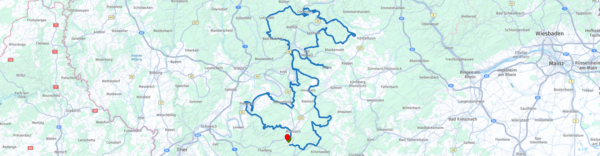
Rondrit Hoxel Cochem Bad Bertrich Piesport

This route was brought to you by:
RouteXpert Marinus van Deudekom (RXpert)
Last edit: 27-02-2025
 Route Summary
 Because of the great roads and bends in this route I rate it 5 stars.
Starting point and end point: The reception of Motorhotel Gus
The GPX data comes from Motorhotel Gus and has been checked again by me and adjusted slightly so that the route is suitable for Here, TomTom and OSM maps.
 Share this route


Animation

Verdict


Duration
10h 2m

Mode of travel
Car or motorcycle

Distance
274.59 km

Countries

 RouteXpert Review
 Soon you will come to the ruins of Burg Balduinseck, a relic from the Middle Ages. Want to get off? Why not. A short break to soak up the atmosphere of this old castle and take a look at the surrounding landscape, before the route really gets going.
In Mörsdorf, stopping at the Geierlay Suspension Bridge is a must. This bridge gives you a spectacular view of the Mörsdorfer Bachtal valley. You have to make an effort because from the parking lot it is more than 1800 meters walk to the bridge. The bridge itself is 360 meters long.
Then the fun really starts. Via Mörsdorf and Valwig you enter a playground for bikers: tight hairpin bends that gracefully wind around the hills. Here you feel how your bike glides seamlessly through the bends, how your body and machine work together in perfect harmony.
And then suddenly the landscape opens up, and there lies the Moselle. The road descends to Cochem, where the impressive Reichsburg Cochem watches over the river like a watchtower. Here you can taste the atmosphere of a town where time seems to stand still.
The route winds along the banks of the Moselle, through Liesnich and Briedel. At the Rundturm am Himmeroder Tor you can take in a bit of history before getting back on and riding along the vineyards that made this region famous.
After all that winding, it's time to catch your breath in Bad Bertrich. This spa town is known for its thermal baths and charming streets. Here you'll also find the stately Kurfürstliches Schlösschen, an elegant building that takes you back to the time of electors and nobility. A perfect place to stretch your legs, have a cup of coffee or just enjoy the peace and quiet before starting the engine again.
The road takes you further to Traben-Trarbach, an atmospheric town with bridges and half-timbered houses. You pass the Moselsteig Lodge in Starkenburg, a place where the view takes your breath away. This is one of those moments when you let everything sink in: the kilometers you have already driven, the wind in your face, the realization that you are in exactly the right place.
And then the Panoramastrasse near Piesport. This is motorcycling at its best. The road climbs and winds high above the Mosel, with views that seem straight out of a postcard. This is the kind of stretch where you can really work on your cornering technique, where you feel every bend and where you experience the ultimate feeling of freedom.
The last few kilometres take you back towards Morbach.
The route includes a number of places for a drink and a bite to eat for yourself and your motorbike, are you obliged to stop here? No, of course you can also determine your own stops.
You end the route at the hotel reception and enjoy a snack and a drink while reflecting on today's route.


 Links
Links  Usage
Usage Want to download this route?
You can download the route for free without MyRoute-app account. To do so, open the route and click 'save as'. Want to edit this route?
No problem, start by opening the route. Follow the tutorial and create your personal MyRoute-app account. After registration, your trial starts automatically.  Disclaimer
Use of this GPS route is at your own expense and risk. The route has been carefully composed and checked by a MyRoute-app accredited RouteXpert for use on TomTom, Garmin and MyRoute-app Navigation.
Changes may nevertheless have occurred due to changed circumstances, road diversions or seasonal closures. We therefore recommend checking each route before use.
Preferably use the route track in your navigation system. More information about the use of MyRoute-app can be found on the website under 'Community' or 'Academy'.

Rheinland Pfalz
About this region
Rhineland-Palatinate (German: Rheinland-Pfalz, [ˈʁaɪ̯nlant ˈp͡falt͡s] (listen)) is a western state of Germany. It covers 19,846 km2 (7,663 sq mi) and has about 4.05 million residents. It is the ninth largest and sixth most populous of the sixteen states. Mainz is the capital and largest city. Other cities are Ludwigshafen am Rhein, Koblenz, Trier, Kaiserslautern and Worms. It is bordered by North Rhine-Westphalia, Saarland, Baden-Württemberg and Hesse and by the countries France, Luxembourg and Belgium.
Rhineland-Palatinate was established in 1946 after World War II, from parts of the former states of Prussia (part of its Rhineland province), Hesse and Bavaria (its former outlying Palatinate kreis or district), by the French military administration in Allied-occupied Germany. Rhineland-Palatinate became part of the Federal Republic of Germany in 1949 and shared the country's only border with the Saar Protectorate until the latter was returned to German control in 1957. Rhineland-Palatinate's natural and cultural heritage includes the extensive Palatinate winegrowing region, picturesque landscapes, and many castles and palaces.
Read more on Wikipedia
Rhineland-Palatinate was established in 1946 after World War II, from parts of the former states of Prussia (part of its Rhineland province), Hesse and Bavaria (its former outlying Palatinate kreis or district), by the French military administration in Allied-occupied Germany. Rhineland-Palatinate became part of the Federal Republic of Germany in 1949 and shared the country's only border with the Saar Protectorate until the latter was returned to German control in 1957. Rhineland-Palatinate's natural and cultural heritage includes the extensive Palatinate winegrowing region, picturesque landscapes, and many castles and palaces.
View region
 Statistics
  143
143Amount of RX reviews (Rheinland Pfalz)
 57699
57699Amount of visitors (Rheinland Pfalz)
 31004
31004Amount of downloads (Rheinland Pfalz)
 Route Collections in this region
 Top 5 Car and Motorcycle Routes in the Eifel
The Eifel is the eastern part of the medium plateau Eifel-Ardennes. It is located north of the Moselle and west of the Rhine. The largest part is in Germany, a small part is in Belgium, in the East Cantons. The German part of Eifel is located in the federal states of North Rhine-Westphalia and Rhineland-Palatinate. The highest point is the Hohe Acht with 747 meters.
Several chains can be distinguished in the Eifel:
The northernmost part is called the Nordeifel, which in Belgium connects to the High Fens;
To the east of this is the Ahrgebirge, this part is located north of the Ahr in the Ahrweiler district;
South of the Ahr is the Hohe Eifel (or Hocheifel), of which the Hohe Acht (747 m) is the highest point, and also the highest point in the entire Eifel region;
To the west, near the Belgian border, the hills are known as Schneifel, part of the wider Snow Eifel area with peaks reaching up to 698 metres;
South and east of the Hohe Eifel is the Volcano-Eifel, a volcanic area with many crater lakes (Maare).
The southern part of the Eifel is less high. The area is bisected by streams and rivers running southwards. These streams flow into the Moselle. The largest of these rivers is the Kyll; the hills around this river are known as the Kyllwald;
In the south, the Eifel ends in the Voreifel.
In the north of the Eifel there are some large reservoirs. The largest of these is the reservoir in the Roer that was created by the construction of the Roerdal dam.
The Nürburgring is also located in the Eifel, a well-known car circuit for Formula 1 races, among other things. Since 2004, part of the north of the Eifel has become the Eifel National Park. This National Park falls entirely within the German-Belgian nature park High Fens-Eifel. Another part of the Eifel falls within the South Eifel Nature Park.
Well-known throughout the Netherlands and Belgium by car and motorcyclists, so reason enough for the MyRoute app RouteXpert to compile a Top 5 of Car and Motorbike routes for you.
All routes in this collection have been checked and made equal for TomTom, Garmin and MyRoute-app Navigation by a MyRoute-app RouteXpert.
If you think, I have a very nice route that should certainly not be missing from this collection, send it to:
email: routeexpert@myrouteapp.com
Subject: New Route for the Top 5 collection Eifel composed by Hans van de Ven.
The route will then be reviewed and then added to the Top 5. To make the Top 5 also the Top 5, 1 route will have to disappear from the Top 5, you can indicate this when submitting the new route.
Have fun with this collection and while driving one of these routes. Enjoy all the beauty that the Eifel has to offer. Click on “View route” to read the review of the chosen route.
I would like to hear your findings about the route(s).
View Route Collection
Route collection hairpins in the Eifel
This collection is composed of the most beautiful and winding roads in the Eifel. Forget Bundesstraßen, forget the road along the Moselle, if you have driven these roads, you can really say that you have been to the Eifel.
No less than 6 routes and 1,800 kilometers are waiting for you!
No less than 6 routes and 1,800 kilometers are waiting for you!
View Route Collection