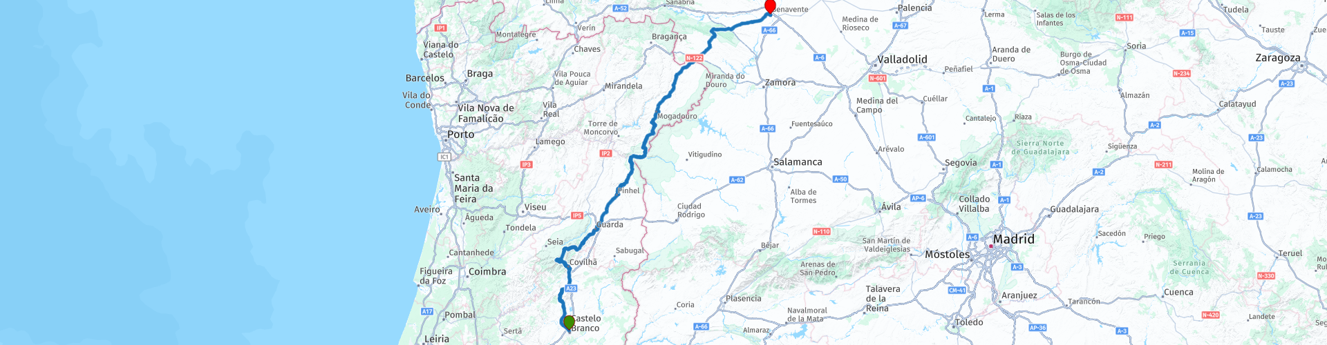
Castelo Branco to Benavente

This route was brought to you by:
RouteXpert Jannes van Dijken
Last edit: 25-04-2025
 Route Summary
 This route passes several National Parks in Portugal. The many beautiful views and wonderful mountain roads make this a route to enjoy.
The nature, the environment and the wonderful roads make this a route that deserves 5 stars without a doubt. The quality of the roads is generally good with a few minor exceptions.
 Share this route


Animation

Verdict


Duration
10h 55m

Mode of travel
Car or motorcycle

Distance
441.74 km

Countries


 RouteXpert Review
 The Parque Natural da Serra da Estrela is the largest protected area in Portugal, located in the Serra da Estrela, the country's highest mountain range. The park covers approximately 1,000 km², more than half of which is above 700 metres. The highest peak, Torre, reaches 1,993 metres, and there is even a ski resort.
This area is known for its spectacular landscapes, including glacial valleys, rock formations and natural lagoons. The Mondego, Zêzere and Alva rivers have their source here. The high altitude and climate mean that snow often falls in winter, making it a popular destination for winter sports.
In addition to nature, the park also has a rich cultural and gastronomic tradition. One of the best-known products from the region is the Queijo da Serra, a creamy sheep's cheese made in an artisanal way. The Serra da Estrela dog, a robust and strong breed used to protect herds, also comes from here.
During the descent there are two, almost obligatory, stops for a photo. The first offers a view of Barragem de Covão do Ferro, a water basin with the valley behind it. The second offers a view of the glacial valley Vale Glaciário do Zêzere, where the route continues later.
The Vale Glaciário do Zêzere is a spectacular glacial valley in the Serra da Estrela, Portugal. This valley, stretching for 13 kilometres, is one of the largest glacial valleys in Europe and a beautiful example of how glaciers have shaped the landscape.
The valley has a characteristic U-shape, which was created by the massive presence of ice during the last ice age. The granite rock formations, such as the Cântaros Magro, Gordo and Raso, give the area an impressive appearance. The Zêzere river flows through the valley, which winds its way through green meadows and past ancient glacial lakes such as Covão D'Ametade, a former glacial lagoon.
After the photo moment it is about an hour and a half to enjoy the beauty of this park. Half an hour further lies Pinhel.
Pinhel is an atmospheric town in Portugal, located in the Centro region and known as the Cidade Falcão (City of the Falcons). The town has a rich history dating back to the Calcolithic period, with archaeological finds in the Côa Valley.
One of the most striking sights is the Pinhel Castle, which dates back to the time of King Denis and played an important role in the defense of Portugal. The city also has a historic center with narrow streets and old houses, some of which show traces of a Jewish community.
Here is also Artisan Burguer, the name says it all, a hamburger restaurant. Highly recommended. The parking lot is right in front of the door.
From Pinhel the route continues north. The Rio Côa is one of the larger rivers that will be crossed today. The Rio Côa is a river in Portugal that rises in the Serra das Mesas, near Foios, Sabugal, at an altitude of 1175 meters. The river flows for about 135 km in a south-north direction, which is quite unique for Portuguese rivers. Finally it flows into the Douro River, near Vila Nova de Foz Côa. The Côa Valley is famous for its prehistoric rock art, which was discovered in the 80s and 90s. This is one of the largest open-air sites of Paleolithic art in Europe and has been a UNESCO World Heritage Site since 1998.
An hour after lunch, the route crosses the Rio Douro. The Rio Douro, also known as the Duero in Spain, is one of the most important rivers of the Iberian Peninsula. The river rises in the Sierra de la Demanda in Spain, at an altitude of 2,200 meters, and flows west through Spain and Portugal before emptying into the Atlantic Ocean at Porto.
At 897 km long, the Douro is one of the longest rivers in the region. Its basin covers approximately 98,000 km², and the river is largely dammed. A special feature of the Douro is that it forms the natural border between Spain and Portugal for almost 100 km. The Douro Valley in Portugal is known worldwide for its vineyards, where the grapes for the famous Port wine are grown. The area has been recognized by UNESCO as a World Heritage Site for its unique landscape and historical significance.
The Parque Natural do Douro Internacional is an impressive natural area in the northeast of Portugal, along the border with Spain. The park covers an area of 868 km² and extends over the municipalities of Miranda do Douro, Mogadouro, Freixo de Espada à Cinta and Figueira de Castelo Rodrigo. This area is known for its rugged landscapes, deep river gorges and steep rock faces, formed by millions of years of erosion by the Douro River. The park is a sanctuary for several species of animals, including the Egyptian vulture, the golden eagle and the Bonelli's eagle.
Besides nature, the park also has a rich cultural and historical significance, with traditional villages and a unique local culture.
The route follows the river for a long time, a road with many bends.
The last 90 kilometres to Benavente are on quiet roads through a beautiful, rolling landscape.
Benavente is a town in the province of Zamora, in the autonomous community of Castile and León, Spain. The town has a rich history and is located at a strategic point where several roads meet, making it an important hub for transport and trade.
Historically, Benavente was repopulated in the 12th century by King Ferdinand II of León, who also granted the town special rights. One of the most notable sights is the Torre del Caracol, a remnant of a 16th-century palace that is now part of the Parador de Turismo Fernando II hotel. There are also beautiful churches, such as the Iglesia de Santa María del Azogue and San Juan del Mercado, which are known for their Gothic and Romanesque architecture.
Benavente also offers a lively atmosphere with pleasant squares, such as the Plaza Mayor, and green areas such as the Jardines de la Mota.
The Parador de Benavente is a wonderful hotel for dinner and an overnight stay.


 Links
Links  Usage
Usage Want to download this route?
You can download the route for free without MyRoute-app account. To do so, open the route and click 'save as'. Want to edit this route?
No problem, start by opening the route. Follow the tutorial and create your personal MyRoute-app account. After registration, your trial starts automatically.  Disclaimer
Use of this GPS route is at your own expense and risk. The route has been carefully composed and checked by a MyRoute-app accredited RouteXpert for use on TomTom, Garmin and MyRoute-app Navigation.
Changes may nevertheless have occurred due to changed circumstances, road diversions or seasonal closures. We therefore recommend checking each route before use.
Preferably use the route track in your navigation system. More information about the use of MyRoute-app can be found on the website under 'Community' or 'Academy'.
Braganca
About this region
Bragança may refer to:
Read more on Wikipedia
View region
 Statistics
  8
8Amount of RX reviews (Braganca)
 23874
23874Amount of visitors (Braganca)
 420
420Amount of downloads (Braganca)
 Route Collections in this region
 Paradors Pousadas And Iberian Passes
This collection is an end-to-end motorcycle journey across northern Spain and Portugal, shaped deliberately to unfold over eleven days with a clear sense of progression. Each stage builds naturally on the last, carrying the rider from the Atlantic edge of northern Spain, south through Portugal’s mountain heartlands and open plains, before returning north across Spain to finish back on the Cantabrian coast.
The journey begins on the Cantabrian coast, leaving Santander behind and climbing steadily inland towards Cervera de Pisuerga. The opening day sets the tone immediately, trading sea air for rising ground and greener hills as the road threads through northern Spain’s quieter interior. It feels purposeful without being rushed, easing the rider into the rhythm of the tour.
From Cervera de Pisuerga, the route pushes deeper into the Cantabrian highlands, crossing broad upland terrain and remote border regions on the way to Bragança. The scenery becomes more expansive, the roads quieter, and the sense of travelling through less familiar Spain grows stronger as the journey approaches Portugal.
Crossing into Portugal, the character tightens again through Montesinho and the Peneda-Gerês region. Roads fold into wooded hills and granite villages, with more frequent elevation changes and a greater sense of enclosure. This is riding that rewards attention and flow rather than outright speed, and it marks a clear transition into Portugal’s mountainous north.
The route then opens into the Douro highlands, running south towards Viseu. Valleys deepen, viewpoints lengthen and the riding alternates between fast, open sections and more intimate stretches that follow the land closely. The sense of scale increases without losing the feeling of remoteness that defines this part of the journey.
Climbing into the Serra da Estrela plateau, the collection reaches one of its defining high points. Portugal’s highest mountain range delivers wide horizons, exposed passes and a feeling of space that contrasts sharply with the valleys below. This stage stands out for its elevation, light and long views, and it feels like a natural midpoint landmark in the overall journey.
Dropping south from the mountains, the route transitions into the Beiras and Alentejo, carrying the rider from high ground into warmer, more open landscapes on the way to Évora. The roads relax into longer, flowing lines, and the pace of the journey subtly changes without losing interest or intent.
From Évora to Beja, the ride settles fully into the heart of the Alentejo. Cork forests, reservoirs and historic hill towns define the scenery, while the riding becomes smoother and more measured. These stages offer breathing space within the collection, allowing the rider to absorb the scale and atmosphere of southern Portugal.
Turning back towards the Spanish border, the route climbs again through Castelo and the border ridges to Marvão. Elevation returns, views stretch out, and the landscape regains a rugged edge. The dramatic setting of Marvão feels earned, sitting high above the surrounding plains and marking a clear shift back towards frontier territory.
Crossing back into Spain, the journey continues through the serranías and frontier regions of Castile, heading for Ciudad Rodrigo. Historic borderlands, rolling terrain and quiet roads reinforce the feeling of travelling through lesser-known landscapes, with riding that remains engaging through variety rather than intensity.
From Ciudad Rodrigo to Benavente, the route crosses the Castilla y León plains. Big skies, long sightlines and subtle changes in terrain define this stage, providing contrast after the mountains while maintaining a strong sense of direction as the journey turns decisively north.
The final day carries the rider from the Meseta back to the Cantabrian coast, closing the loop at Santander. As greener hills return and the Atlantic air reappears, the transition from inland Spain back to the coast provides a fitting and satisfying conclusion, both geographically and emotionally, to the journey.
Throughout the collection, the choice of Paradors and Pousadas anchors each day in history and landscape. These are not simply places to stop, but destinations that reinforce the character of each region and give the journey a sense of occasion from start to finish.
Taken as a whole, this is a coherent and rewarding Iberian tour: varied without feeling fragmented, demanding enough to stay engaging without becoming tiring, and designed to be ridden as a complete journey rather than a series of disconnected stages. It is best suited to riders who value flow, scenery and progression, and who appreciate the satisfaction of a route that unfolds naturally over time.
View Route Collection
Northern Portugal Route: The Ultimate 3-Day Road Trip
The Legendary Douro Curves Route Collection
Discover Portugal through a collection of three unforgettable routes, each showcasing a different side of the country's most spectacular landscapes. From the historic hilltops of Figueira de Castelo Rodrigo to the terraced vineyards of Vila Nova de Foz Côa, this journey combines scenic roads, charming villages, mountain passes, breathtaking viewpoints, and the world-famous Douro Valley.
The adventure begins with The Famous North Route, crossing the authentic landscapes of northern Portugal on the way to Chaves. It continues with The Atlantic & Douro Route, where winding mountain roads meet the beauty of the Douro River before reaching the Atlantic influence. The journey concludes with The Legendary Douro Curves Route, following some of Portugal's most iconic driving roads through the UNESCO World Heritage Douro Valley, surrounded by endless vineyards, dramatic viewpoints, and unforgettable scenery.
Three routes, three unique experiences, and one extraordinary road trip—created for those who love exceptional driving, breathtaking landscapes, and the timeless beauty of Portugal.
View Route Collection