Fortified Cities from Avesnes

This route was brought to you by:
RouteXpert Jan Koelstra - Senior Rx
Last edit: 09-06-2025
 Route Summary
 In addition to admiring these fortifications, attention is also paid to the fortified towns and villages themselves as well as the general sights. The most important military fortifications of both world wars are also mentioned along the route.
The route is rated five stars because of the alternation between the vastness of the landscape, the pleasant, sometimes surprising roads on the one hand and the ingenious constructions of the fortified towns and forts on the other.
 Share this route


Animation

Verdict


Duration
6h 40m

Mode of travel
Car or motorcycle

Distance
196.29 km

Countries


 RouteXpert Review
 The claims of Louis XIV of France on Flanders resulted in five French occupations between 1646 and 1706 and the construction of fortifications as well as the construction of the citadel of Kortrijk. During the wars of Louis XIV of France it became clear that the Spanish Empire was no longer able to defend the Southern Netherlands. If the Southern Netherlands were lost, France would become a threat to the Republic and to the balance of power in Europe.
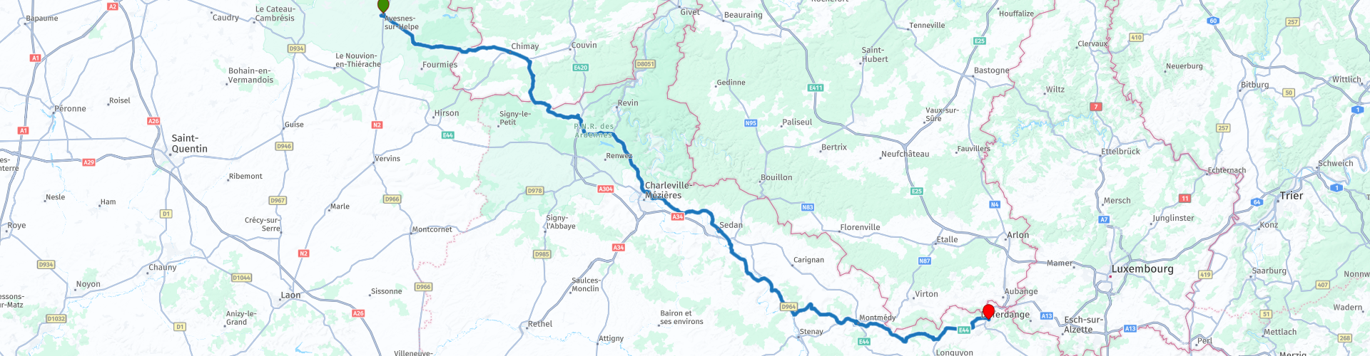
This route starts in the fortified town of Avesnes-sur-Helpe and ends in Longwy, near Luxembourg. It visits a total of five fortified towns, but during the journeys, we literally or figuratively stop at other beautiful things along the way.
Avesnes was already an important place in the Middle Ages. It was one of the most important strongholds of Charles V. Under his protection it was able to hold its own well. In 1502 the city wall was repaired and between 1534 and 1538 six bastions were built. The city was thus a stronghold in the defense of the Spanish Netherlands against France. The city returned to France definitively in 1659. Due to the threat of attacks and sieges, the fortifications had to be constantly expanded, as is shown by the spectacular Bastion Saint-Jean, completed in 1659. This was followed by a quiet period during which, sheltered from the fortifications revised by Vauban (particularly the Pont-des-Dames), the town hall and 300 houses were rebuilt. During the restoration, the Bastion Saint-Louis was built, including casemates that served as storage space. However, from 1873 onwards they were dismantled, so that most of the ramparts remained. What remains is now protected. Of the historical fortifications, the Pont des Dames should be mentioned in particular, which was used to flood the area around the city as part of the defence system. The Pont is therefore located close to the locks.
In Rocroi, things are different: this town was largely built from scratch in the 16th century, specifically as a fortified town. And since then, little seems to have changed, so you still get a very good idea of what it once looked like. Walk from your parking spot on the square of Rocroi to the local Office de Tourisme and soak up the atmosphere. Rocroi is not a super touristy place and that has its pros and cons. A definite disadvantage is that there are plenty of cars parked on the square in the middle of the town. People just live here, no pedestrian zone or banishment of cars to outside the city walls. That is of course a shame for the authentic historical experience of this town, but at the same time it is not very difficult to look through the modern era to what it used to be like. What is special about the town is that it was built according to a strict plan. From the central square, ten streets run in all directions to the city walls. This was done so that the soldiers could defend the town in no time in the event of a sudden attack. Almost everything in this town is reminiscent of its military past. For example, you walk past a powder house where gunpowder used to be stored. There are three of these types of buildings in Rocroi. From the outside, they look like a normal house, but they have thick walls of several meters, and a vaulted interior. All of them are made of brick, so that in the event of an explosion or damage, the building could be quickly repaired. The highest bastion of the town offers a beautiful view of the city walls. These are largely still in their original state. Only the elevation that offers a view of the city was added later, for the tourists. In total, the defensive walls around the city are about four kilometers long. In between, you pass various bastions and storage areas. There is also a long tunnel accessible where soldiers used to be able to walk through unseen.
The museum tells the story of the most important historical event in this area, the Battle of Rocroi. A battle that ended the Thirty Years' War, a resounding victory for the French over the Spanish. Nowadays, this battle hardly gets any attention in school books about this region, mainly because of the impact of later wars here. But for Rocroi it remains a memorable event. The museum is located on the northeast side of Rocroi, at one of the three access roads. Around it, you can also admire a few large barracks and officers' houses, and one of the other gunpowder storages. Nowadays, it houses a media library; feel free to walk in to see the vaulted roof.
A walk through Rocroi ends with a delicious local beer on a terrace on the square of Rocroi. With a view of the church and the wooden market hall of Rocroi you may think back to earlier times. What would it have been like to have lived here as a soldier?
Initially, the site of the Château de Sedan was occupied by only a Benedictine church. In the 15th century, Everhard de la Marck had a fortified and completely walled manor house built there. His grandson Robert then made sure that it could withstand artillery attacks, a novelty at the time. Walls were made higher and thicker, terraces for cannons were constructed and a 'ring road' was built over which the defences could move quickly. The Château de Sedan is one of the largest medieval fortresses in Europe, with an area of 35,000 m2 on seven levels. It is the only remnant of the former fortifications in and around the city. In 1870 (the defeat in the Franco-Prussian War) most of the defences were destroyed, except for the castle. The castle has seven floors and the thickest walls are up to 27 m wide. Two round towers built around 1430 served as the castle gate. The now disappeared church of the castle was built against these towers. The princely apartments were built from 1530 and are 105 m long. After 1614, the princes of Sedan took over the more comfortable Palais des Princes in the outer bailey. During the same construction period (1530), the Renaissance pavilion was built according to plans by Philibert Delorme. This pavilion is decorated with Tuscan pillars and forms the entrance to the museum. When you look around you from the inner courtyard, the military history of the fort is particularly visible. Everything is sober and austere. No fashionable frills, but facades that look severe with their thick walls and small windows. When the French state took over the castle from the last lords and princes of Sedan, it mainly served as a stronghold and barracks.
Montmédy is a city within a city. In the heart of this fortified city, alleys wind around the squares. The artists' studios add an extra touch. Montmédy was above all an overwhelming citadel, one of the most impressive in Northern France. Charles V had it built in 1525 as a defense against attacks from ... the French. At that time, the region was under the rule of the Austrian Netherlands. The troops of Louis XIV besieged Montmédy and took this strategic location. After it became French property, Vauban rebuilt the fort according to the most modern military ideas of the time and gave it the shape that was so characteristic of him. The fort has a number of defensive walls around it in a kind of star shape. The idea behind this is that the enemy becomes disoriented once inside the first walls. To reach the fort, you first have to go through a number of walls and cross moats. The fort has experienced several wars. The first major test was the Napoleonic Wars, during which it was badly damaged. In the second half of the 19th century, it was the scene of a battle between France and Prussia. Some damaged houses in the village were bombed during that period. In the First World War, the garrison left the fort to flee to nearby Verdun. It never regained a defensive function. When visiting the fort, you can climb the ramparts and walk all the way around the town. You will get a good impression of the defence lines and the area surrounding the town.
In Longwy, the fortifications of Vauban are so special because they are one of the few that were built entirely according to the design of this French fort builder. In most places, Vauban built on existing fortifications between 1679 and 1690. The fortifications are part of the World Heritage List Fortifications of Vauban. The former castle of Longwy was demolished to make way for these fortifications. In its place came a park with an arboretum. The church of Saint-Dagobert was built from 1680 in the new Ville-Haute, within the ramparts. The church was protected as a historical monument in 1933.


 Links
Links  Usage
Usage Want to download this route?
You can download the route for free without MyRoute-app account. To do so, open the route and click 'save as'. Want to edit this route?
No problem, start by opening the route. Follow the tutorial and create your personal MyRoute-app account. After registration, your trial starts automatically.  Disclaimer
Use of this GPS route is at your own expense and risk. The route has been carefully composed and checked by a MyRoute-app accredited RouteXpert for use on TomTom, Garmin and MyRoute-app Navigation.
Changes may nevertheless have occurred due to changed circumstances, road diversions or seasonal closures. We therefore recommend checking each route before use.
Preferably use the route track in your navigation system. More information about the use of MyRoute-app can be found on the website under 'Community' or 'Academy'.

Grand Est
About this region
Grand Est (French: [ɡʁɑ̃t‿ɛst] (listen); Alsatian: Grossa Oschta; Moselle Franconian/Luxembourgish: Grouss Osten;
Rhine Franconian: Groß Oschte; German: Großer Osten [ˈɡʁoːsɐ ˈʔɔstn̩]; English: "Greater East") is an administrative region in Northeastern France. It superseded three former administrative regions, Alsace, Champagne-Ardenne and Lorraine, on 1 January 2016 under the provisional name of Alsace-Champagne-Ardenne-Lorraine (pronounced [alzas ʃɑ̃paɲ aʁdɛn lɔʁɛn]; ACAL or, less commonly, ALCA), as a result of territorial reform which had been passed by the French Parliament in 2014.The region sits astride three water basins (Seine, Meuse and Rhine), spanning an area of 57,433 km2 (22,175 sq mi), the fifth largest in France; it includes two mountain ranges (Vosges and Ardennes). It shares borders with Belgium, Luxembourg, Germany and Switzerland. As of 2017, it had a population of 5,549,586 inhabitants. The prefecture and largest city, by far, is Strasbourg.
The East of France has a rich and diverse culture, being situated at a crossroads between the Latin and Germanic worlds. This history is reflected in the variety of languages spoken there (Alsatian, Champenois, and Lorraine Franconian). Most of today's Grand Est region was considered "Eastern" as early as the 8th century, when it constituted the southern part of the Francian territory of Austrasia. The city of Reims (in Champagne), where Frankish king Clovis I had been baptized in 496 AD, would later play a prominent ceremonial role in French monarchical history as the traditional site of the coronation of the kings of France. The Champagne fairs played a significant role in the economy of medieval Europe as well. Alsace and Lorraine thrived in the sphere of influence of the Holy Roman Empire for most of the Middle Ages and Renaissance, and subject to competing claims by France and German over the centuries.
The region has distinctive traditions such as the celebration of Saint Nicholas Day, Christmas markets, or traditions involving the Easter hare in Alsace and Lorraine. Alsace-Moselle are furthermore subject to local law for historical reasons. With a long industrial history and strong agriculture and tourism (arts, gastronomy, sightseeing), the East of France is one of the top economic producing regions in the country.
Read more on Wikipedia
Rhine Franconian: Groß Oschte; German: Großer Osten [ˈɡʁoːsɐ ˈʔɔstn̩]; English: "Greater East") is an administrative region in Northeastern France. It superseded three former administrative regions, Alsace, Champagne-Ardenne and Lorraine, on 1 January 2016 under the provisional name of Alsace-Champagne-Ardenne-Lorraine (pronounced [alzas ʃɑ̃paɲ aʁdɛn lɔʁɛn]; ACAL or, less commonly, ALCA), as a result of territorial reform which had been passed by the French Parliament in 2014.The region sits astride three water basins (Seine, Meuse and Rhine), spanning an area of 57,433 km2 (22,175 sq mi), the fifth largest in France; it includes two mountain ranges (Vosges and Ardennes). It shares borders with Belgium, Luxembourg, Germany and Switzerland. As of 2017, it had a population of 5,549,586 inhabitants. The prefecture and largest city, by far, is Strasbourg.
The East of France has a rich and diverse culture, being situated at a crossroads between the Latin and Germanic worlds. This history is reflected in the variety of languages spoken there (Alsatian, Champenois, and Lorraine Franconian). Most of today's Grand Est region was considered "Eastern" as early as the 8th century, when it constituted the southern part of the Francian territory of Austrasia. The city of Reims (in Champagne), where Frankish king Clovis I had been baptized in 496 AD, would later play a prominent ceremonial role in French monarchical history as the traditional site of the coronation of the kings of France. The Champagne fairs played a significant role in the economy of medieval Europe as well. Alsace and Lorraine thrived in the sphere of influence of the Holy Roman Empire for most of the Middle Ages and Renaissance, and subject to competing claims by France and German over the centuries.
The region has distinctive traditions such as the celebration of Saint Nicholas Day, Christmas markets, or traditions involving the Easter hare in Alsace and Lorraine. Alsace-Moselle are furthermore subject to local law for historical reasons. With a long industrial history and strong agriculture and tourism (arts, gastronomy, sightseeing), the East of France is one of the top economic producing regions in the country.
View region
 Statistics
  84
84Amount of RX reviews (Grand Est)
 42699
42699Amount of visitors (Grand Est)
 14339
14339Amount of downloads (Grand Est)
 Route Collections in this region
 25 Magnificent trails in France
This MRA route collection contains 25 beautiful motorcycle routes in different parts of France, such as the Ardennes, the Alsace, Vercors, the Drôme, the Ardèche, Cote d'Azure, Gorges du Verdon, the Ariège, the Dordogne and Brittany.
The routes have been carefully created by Bert Loorbach, who is an enthusiastic motorcyclist himself. He lived in France for a year and a half, during which time he devoted himself to mapping the unknown and beautiful back roads of France especially for motorcyclists.
The routes are bundled in the Motortourgids France part 1 of Kosmos publishing house and now also available in MyRouteApp.
I have taken over the routes in MRA and sometimes adjusted them slightly to make them even more interesting for the motorcyclist.
View Route Collection
11 day trip from the Netherlands
8 countries in 11 days; The Netherlands, Germany, Austria, Italy, Switzerland, France, Luxembourg and Belgium. This route collections consists of 10 routes that I have driven with friends in the summer of 2019.
The start is in Geldermalsen Netherlands, the first 7 days you drive through the Netherlands, Germany, Austria, Italy, Switzerland, France and a piece of Luxembourg with overnight stays in hotels.
The last three days you stay in Barweiler (D) in the Eifel and you drive two beautiful tours through the Eifel, Luxembourg and parts of the Belgian Ardennes.
There is no highway in the routes, only beautiful provincial and country roads, many beautiful passes with beautiful panoramas.
Be sure to check whether the passes are open before you leave.
These are routes for experienced drivers.
View Route Collection