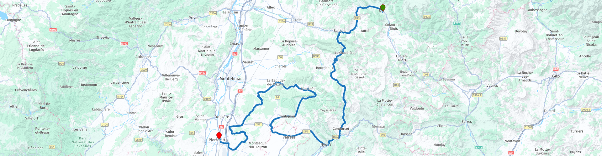
Dauphine region from Die

This route was brought to you by:
RouteXpert Jan Koelstra - Senior Rx
Last edit: 26-06-2025
 Route Summary
 Some are well-known, Valréas, Nyons and Die. Others are less visible, such as the picturesque villages of Dieulefit, Le Poët-Laval, Saint-Paul-Trois-Châteaux La Garde-Adhémar. But they are all exceptional for their cultural heritage, their panoramas, their hidden treasures. The best thing: they are all easy to visit all year round with the help of the guided tours offered!
The unique area of the regional parks is not only characterized by the flora and fauna of the park, but also by the archaeology, the built heritage, the landscape, the mountain villages, the culture, the customs. That is why this exploration tour, which also takes you along exciting roads, gets a five-star rating.
 Share this route


Animation

Verdict


Duration
7h 41m

Mode of travel
Car or motorcycle

Distance
196.43 km

Countries

 RouteXpert Review
 The province offers a varied landscape between the Alpine peaks of the Haut-Dauphiné, the Pre-Alps, the Balconies of the Dauphiné or those of Valentinois and the western part of the Drôme Provençale, which have a more Mediterranean character.
In the Drôme, the Alps and Provence, the warm sun and wonderful scents come together. From the rugged mountain peaks of the Vercors to the soft hills of the Drôme Provençale, from the bustling markets in the larger cities to the quiet villages where the locals are proud of their traditions and time seems to stand still. The Baronies Provençales nature park extends over a large part of the southern Drôme, but Nyons is located in the centre and is therefore an ideal base for exploring it. The rich nature, the climate, the lavender fields, the olive groves and vineyards interspersed with unique villages such as Grignan, Dieulefit and Valréas, form an ideal environment for an active holiday. There is even an enclave to be found here. The Enclave des Papes or enclave of the popes was a piece of papal territory (1317-1791) in the principality of Dauphiné. Since 1791, the entity still exists as the canton of Valréas with the communes of Valréas, Grillon, Richerenches and Visan, an exclave of the Vaucluse department or enclave in the Drôme department.
This tour takes you through the southwestern part of the Dauphiné, the Drôme department, starting in Die, the city of the Clairette de Die and ending in the crocodile town of Pierrelatte on the Rhône.
The town of Die probably originated in the first century AD. The first remains that have been found date from the second century AD. The most prominent sights of the village are the Gallo-Roman walls and the city gate 'Saint-Marcel' which date from the third century. Also beautiful are the Roman mosaics in the old chapel Saint-Nicolas, an old private chapel of the bishops. All beautiful streets in Die.
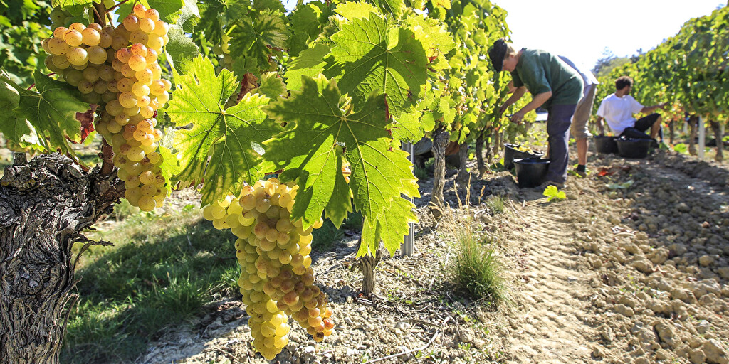
The town is known for its Clairette, a white slightly sparkling wine that you can get both dry and sweet. In the vicinity of Die there are several winegrowers where you can buy Clairette and learn more about the winemaking process.
After refuelling, head west to Pontaix, a pretty Drôme village at the foot of the Vercors. The Drôme river that runs through the village, lined with houses, brings welcome refreshment in the summer. During the religious wars, this was a Protestant stronghold of the Diois region, but these fortifications were destroyed at the end of the 16th century. The castle chapel, high above the river, has two beautiful oriel windows. It has remained a Protestant temple since the 16th century, with frescoes from the 13th and 14th centuries. At the top of the village, the ruins of the former castle and its pentagonal keep majestically dominate the landscape. From the village, a beautiful road leads to the ridge, where a breathtaking view of the Drôme valley awaits you! Don't forget to admire the beautiful Aiguebelle waterfalls, which can also be found in the upper part of Pontaix. You get there via the "Calade de la Cascade", a tiny hidden street that takes you to the path towards the cascade.
In the old town of Nyons you take a break for coffee and a visit. A history that goes back to the Romans when Nyons was an administrative part of Vaison-la-Romaine, located a little further south. The Pont Roman is still an impressive witness to that time. But the city has many more historical gems. Such as the Tour de Randonne, a former military prison in the old centre, the Quartier des Forts. A 3.5 metre high statue of Mary has been watching over the city since 1280. The historical city centre can easily be discovered before or after a terrace on the pleasant Place de la Libération.
If you are there on a Thursday, you can buy the best olive oil of Provence at the weekly market. Also learn more by visiting the Musée de l'Olivier or one of the olive mills not far from the Pont Roman where olive oil is still produced in the traditional way. The black olive is 'big business' here. More than 1100 olive groves are united in the Vignolis cooperative and the 'Olive de Nyons' is not just any olive, it is a widely recognized 'appellation d'origine protégée' (AOP).
Driving to Valreas you end up in a (now) departmental enclave.
Valréas, a major city of the Papal States, has preserved a rich heritage from the past: the city is dominated by the tower of the old Château Ripert (12th century) and by the imposing 12th century church of Notre-Dame-de-Narareth with its 17th century organ. The Château de Simiane (17th century fresco) where Pauline de Grignan, granddaughter of Madame de Sévigné, lived, now houses the town hall. Here you can pick up a route to visit all the monuments in the city. But also outside you will find many fields of lavender and lavandin used for cosmetics.
Grignan is built on a hill that offers a beautiful view of the region where you can see and smell fields of lavender and thyme. On top of the hill is the castle that was built as a military fortress at the beginning of the 11th century. In the 15th century, the fortification was converted into a castle where luxury and wealth became the main features. Until well into the 17th century, the castle was made more and more beautiful. During the French Revolution, the castle of Grignan did not escape the plundering that put an end to the wealth of quite a few wealthy families in France. The castle was looted and the contents were sold. In the course of the 19th and 20th centuries, the castle was completely redecorated in various phases to the state it must have looked in its glory days.
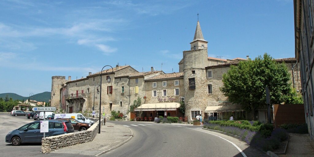
The beautiful medieval town of Taulignan was built between the 10th and 15th centuries. Eleven towers that strengthen the ramparts are still visible. Walking around it, you will pass the Romanesque chapel of Saint-Michel from the 11th century and the Protestant temple in the form of a round tower. Originally there were even fourteen defensive towers
There is also the northern gate, or Porte d'Anguille, flanked by two towers connected by a gallery of hurdles. The town has many Renaissance facades and houses from the 17th and 18th centuries.
Dieulefit is a very different place. Pottery has always been closely linked to the history of Dieulefit and its surroundings. In the past, traditional pottery for home use was produced from clay that was mined locally. Great names in the field of ceramics, such as Etienne Noël or Jacques Pouchain, have also left a significant mark on the pottery tradition. Today, many potters and ceramists exhibit their work in their studios, galleries or shops. This artistic tradition has also extended to painting and sculpture. Many art galleries have set up shop in the heart of the village.
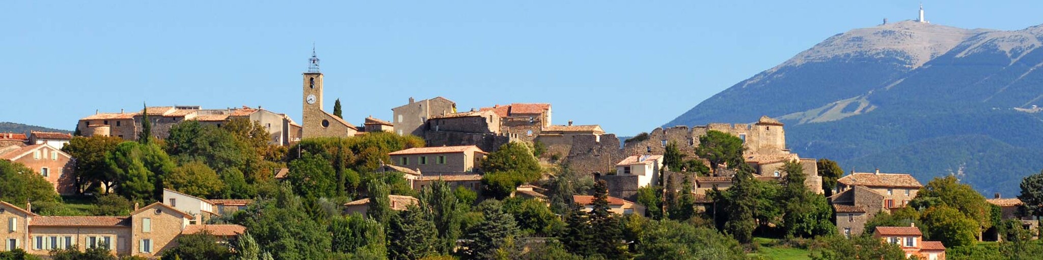
The next village is Le Poët-Laval, with its impressive medieval donjon (dwelling tower). It stands out spectacularly against the wooded hills. Founded in the 12th century by the Order of Saint John of Jerusalem (the Hospitallers), the village experienced a lot of turbulence from the end of the Middle Ages, like most other villages in the region. The Wars of Religion marked the beginning of a slow decline that almost ended the village as a ghost town four centuries later. But the village came back to life thanks to the determination of a few enthusiastic town planners
Fancy a visit to the abbey? The village of Montjoyer developed in the 12th and 13th centuries under the impetus of the Cistercian monks from the nearby Aiguebelle Abbey. Montjoyer still has medieval alleys with covered passages and part of the ramparts. The Grange de Montjoyer, built by the Cistercian monks who founded the Notre Dame d'Aiguebelle Abbey in 1137, is at the origin of the village that developed in the 12th and 13th centuries. At the entrance to the village stands an imposing white church from the 19th century. The abbey, located in a valley, is still home to a Cistercian community of around thirty monks who make a living from manual labour, help the poor as much as possible and welcome anyone who wants to free up time for meditation in their lives. There is no guided tour of the abbey, only access to the church. The shop with regional and monastic products, with a video room about monastic life in the abbey, is in the exhibition area of the shop.
The elevated La Garde-Adhémar is located on top of a chalky rock face and looks out like a fearless sentinel over the entire Rhône valley, a breathtaking view. If possible, do this from a terrace, where you can have lunch. Also visit the Jardin des Herbes here. This protected herb garden is a beautiful example of a classic French garden.
In the heart of Tricastin, Clansayes seduces with its unspoilt environment and remarkable heritage. This village, typical of the Drôme Provençale, is perched on a rocky peak and offers a beautiful view of the surrounding hills and scrubland. The charming alleys lead to medieval remains, including the impressive tower, a testament to the town's fortified past. In 1772, Clansayes was struck by a major earthquake. It was one of the first to be studied scientifically. The village was off-limits for ten years. Only a few buildings remained standing.
Contrary to what its name suggests, Saint-Paul-Trois-Châteaux does not have any castles (a mistranslation of Tricastin), but its heritage is no less exceptional! The historic centre is full of treasures and architectural masterpieces, starting with the magnificent Notre Dame Cathedral. This jewel of Provençal Romanesque style, classified as a Historical Monument, was built between the 12th and 13th centuries.
Pierrelatte will surprise you with its narrow streets where the scent of legends and myths still lingers. Play Gargantua in the Provencal village overlooking the Rhône plain, explore the old town centre around the majestic rock and spend a moment of peace in the shade of the mill.
According to legend, the giant Gargantua once sat on top of Mont Ventoux to retrieve a stone from his boot. He threw it far away and it landed in the middle of a large plain. This is how Pierrelatte, or at least its Rocher, was born, a small stone falling from a giant boot.
The mill, the museum and the Provencal character are the perfect combination for an authentic immersion in the history and heritage of Pierrelatte. Built in 1839, the Moulin de Pierrelatte embodies the charm and authenticity of the Provencal mills. In use until 1880, the building has stood the test of time, while retaining its old-fashioned appearance. At the foot of the Rock, within the walls of a former prison, the Pierrelatte municipal museum invites you to discover the town's hidden treasures. Through its collections of archaeology, palaeontology and mineralogy, you will discover the unsuspected riches of Pierrelatte. And then there is the Village Provençal, brought to life by 341 santons, 114 of which are in motion. It brings to life the crafts of yesteryear and immerses you in an atmosphere steeped in tradition. When you look out over this miniature village, you feel like a giant, true to the mythical origins of Pierrelatte. Every detail, every scene seems so real that it is impossible not to end this visit with a head full of wonder, lulled by the scent of Provence. Finally, the Rocher de Pierrelatte, an impressive limestone block, on which a castle was built in the Middle Ages, then the rock became a quarry in the 1913th century. After years of exploitation, the city decided in 1919 to preserve this unique site. Today, it has been converted into an open-air theatre and welcomes artists every summer for the Rocher Festival. Outside the centre is a crocodile farm. La Ferme aux Crocodiles is a zoo with a large indoor enclosure that houses several hundred crocodiles. In addition to the crocodiles, there are also turtles and birds to see.
 Links
Links  Usage
Usage Want to download this route?
You can download the route for free without MyRoute-app account. To do so, open the route and click 'save as'. Want to edit this route?
No problem, start by opening the route. Follow the tutorial and create your personal MyRoute-app account. After registration, your trial starts automatically.  Disclaimer
Use of this GPS route is at your own expense and risk. The route has been carefully composed and checked by a MyRoute-app accredited RouteXpert for use on TomTom, Garmin and MyRoute-app Navigation.
Changes may nevertheless have occurred due to changed circumstances, road diversions or seasonal closures. We therefore recommend checking each route before use.
Preferably use the route track in your navigation system. More information about the use of MyRoute-app can be found on the website under 'Community' or 'Academy'.

Provence Alpes Cote d Azur
About this region
Provence-Alpes-Côte d'Azur (French pronunciation: [pʁɔvɑ̃s‿alp kot d‿azyʁ]; Occitan: Provença-Aups-Còsta d'Azur, [pɾuˈvɛnso̞ ˈawps ˈkɔsto̞ daˈzyɾ], or Provença-Alps-Còsta d'Azur, [pɾuˈvɛnso̞ ˈalps ˈkɔsto̞ daˈzyɾ]; commonly shortened to PACA; English: Provence-Alps-French Riviera; also known as Région Sud) is one of the eighteen administrative regions of France, the far southeastern on the mainland. Its prefecture and largest city is Marseille. The region is roughly coterminous with the former French province of Provence, with the addition of the following adjacent areas: the former papal territory of Avignon, known as Comtat Venaissin; the former Sardinian-Piedmontese County of Nice, whose coastline is known in English as the French Riviera and in French as the Côte d'Azur; and the southeastern part of the former French province of Dauphiné, in the French Alps. Previously known by the acronym PACA, the region adopted the name Région Sud as a commercial name or nickname in December 2017. 5,007,977 people live in the region according to the 2015 census.
It encompasses six departments in Southeastern France: Alpes-de-Haute-Provence, Alpes-Maritimes, Bouches-du-Rhône, Hautes-Alpes, Var and Vaucluse. It is bounded to the east by the France–Italy border, to the south by the Mediterranean Sea and by the Principality of Monaco, to the north by Auvergne-Rhône-Alpes and to the west by Occitanie, with the Rhône marking its westernmost border. The region logotype displays the coat of arms created in the 1990s and which combines the coats of arms of the old provinces making up Provence-Alpes-Côte d'Azur. The region's economy is the third largest in France, just behind Île-de-France and Auvergne-Rhône-Alpes. Its GDP in 2012 was €142.4 billion (US$183.1 billion) while its per capita GDP was €28,861 ($US 37,121).
Read more on Wikipedia
It encompasses six departments in Southeastern France: Alpes-de-Haute-Provence, Alpes-Maritimes, Bouches-du-Rhône, Hautes-Alpes, Var and Vaucluse. It is bounded to the east by the France–Italy border, to the south by the Mediterranean Sea and by the Principality of Monaco, to the north by Auvergne-Rhône-Alpes and to the west by Occitanie, with the Rhône marking its westernmost border. The region logotype displays the coat of arms created in the 1990s and which combines the coats of arms of the old provinces making up Provence-Alpes-Côte d'Azur. The region's economy is the third largest in France, just behind Île-de-France and Auvergne-Rhône-Alpes. Its GDP in 2012 was €142.4 billion (US$183.1 billion) while its per capita GDP was €28,861 ($US 37,121).
View region
 Statistics
  61
61Amount of RX reviews (Provence Alpes Cote d Azur)
 61038
61038Amount of visitors (Provence Alpes Cote d Azur)
 4188
4188Amount of downloads (Provence Alpes Cote d Azur)
 Route Collections in this region
 The 24 Most Beautiful Alpine Routes
The Alps, The Alps are a mountain range in Europe, stretching from the French Mediterranean coast in the southwest to the Pannonian Plain in the east. The area of the mountain range is more than 200,000 km².
In other words Passes and Mountain Roads!
Driving through the mountains is great! Especially over the mountain passes with hairpin bends and narrow winding roads. Every bend a different view where you can enjoy. There are many beautiful mountain passes in the Alps.
A selection that has also been incorporated into these routes:
The Stlevio Pass:
The Stelvio Pass, also known as Passo dello Stelvio, is mainly known for the stage in the Giro d'Italia. Due to the length and the difference in height, this pass is seen as one of the toughest tests in cycling. The Stelvio Pass reaches a maximum height of 2758 meters and is therefore one of the highest in the Alps. The pass connects the towns of Bormio and Prato Allo Stelvio. In winter the pass is closed due to heavy snowfall.
The Reschenpass:
The Reschenpass, also known as Passo di Resia, connects the Austrian state of Tyrol with the Italian province of South Tyrol. The pass reaches a maximum height of 1,504 meters and has been one of the most important north-south connections in the Alps in recent centuries. The pass was used long before Roman times. Along the way you will pass several highlights and historical relics. One of the highlights is the Reschensee. This lake was created after the construction of the dam and has completely submerged the village of Graun. The only thing that reminds of that is the clock tower in the middle of the lake.
Col du Galibier:
The French mountain pass Col du Galibier connects the towns of Saint-Michel-de-Maurienne and Briançon via the Col du Lautaret in the south and the Col du Télégraphe in the north. The mountain pass is part of the Tour de France and very much feared, due to the fact that it can only be reached via the other two mountain passes. The pass reaches a maximum height of 2646 meters. From there you can take a walk to the viewpoint at 2704 meters. You can admire the peaks of the Grand Galibier, Mont Blanc and La Meije here.
The Grossglockner High Alpine Road:
With a height of 3798 meters the Grossglockner is the highest mountain in Austria. To fully enjoy this impressive mountain, you can drive over the Grossglockner High Alpine Road and the accompanying pass. The route starts from Bruck am Grossglockner and ends in Heiligenblut. Of course you can drive in two directions. The pass reaches a maximum height of 2504 meters and is closed in winter due to heavy snowfall. Along the way you pass several stops with fun activities, information points, mountain huts and viewpoints. A visit to the Kaiser-Franz-Josefs-Höhe and Pasterzen Glacier is highly recommended.
The Col d'Izoard:
Just like the Col du Galibier, the Col d'Izoard is also part of a stage of the Tour de France. The mountain pass connects Briançon with the valley of the river Guil. The pass is partly located in the Regional Natural Park du Queyras and reaches a maximum height of 2360 meters. What is special about the Col d'Izoard is the barren and rocky landscape. Sometimes it feels like driving a car over the moon! Along the way you can stop at several points to enjoy the beautiful view.
The Bernina Pass:
The Bernina Express is one of the most famous rail trains in Switzerland and the Alps. The route is beautiful and partly included on the UNESCO World Heritage List. Parallel to the railway lies the Bernina pass, which connects the Veltlin valley with the Egandin valley. This beautiful Alpine road has a total length of 56 kilometers and reaches a maximum height of 2328 meters. Along the way you can enjoy views of the Morteratsch Glacier.
The Sella Pass:
The Sella Pass, also known as Passo di Sella, takes you over one of the most impressive mountain ranges in the Dolomites: the Sella massif. The pass connects Valle di Fassa with Val Gardena and reaches a maximum height of 2236 meters. At this height is also the border of the Italian provinces of Trentino and Bolzano. Along the way you can enjoy the view of this spectacular mountain world. Admire, for example, the three peaks of the Sasso Lungo massif, the Sella massif or the peaks of the Marmolada. You can also drive the Sella pass in combination with the Gardena pass, Pordoi pass and Campolongo pass.
The Grimsel Pass:
The Grimsel Pass connects Goms in Wallis with the Halis Valley in the Bernese Oberland. The pass reaches a maximum elevation of 2165 meters and is closed in winter due to snowfall. Over the centuries, the mountain pass has played an important role in trade between Switzerland and Italy. Now it is mainly the reservoirs that have an important function. These are used to generate electricity. The landscape you drive through is rugged, rocky and impressive. On top of the pass is a hotel and a restaurant with a special marmot park. The Dodensee (Totensee) is also located here. This lake owes its name to the many soldiers who died in the time of Napoleon.
The Gotthard Pass:
The Gotthard Pass, also known as Passo del San Gottardo and Saint Gotthard, connects the Swiss towns of Airolo and Andermatt. The mountain pass and associated tunnel are especially known among holidaymakers driving from Switzerland to Italy. But where the majority opt for the tunnel, it is precisely the pass that really completes the holiday. The Gotthard Pass has a length of about 26 kilometers and reaches a maximum height of 2106 meters. The route is beautiful and takes you along old villages and beautiful views.
The Silvretta High Alpine Road and Silvretta Pass:
The Paznaun Valley in Tyrol and the Montafon in Vorarlberg are connected by the Silvretta High Alpine Road. The route has a length of 22.3 kilometers and leads from Galtür to Partenen in 34 hairpin bends, via the 2032 meter high Bielerhöhe. The Silvrettasee is also located at this point, where you can enjoy a lovely walk. The pass is closed in winter due to snowfall.
The Simplon Pass:
Just like the Gotthard Pass, many holidaymakers also travel over the Simplon Pass every year. This mountain pass connects the Rhone Valley in the canton of Valais with the Valle d'Ossola in Piemonte. The pass is open all year round and reaches a maximum height of 2005 meters. Along the way you pass a number of buildings, including the well-known Simplon Hospiz from 1825. The hospiz is managed by the monks of St. Bernard. From the highest point on the pass, all kinds of hiking routes are possible and you will also come across a hotel where you can spend the night.
The Gerlos Pass:
The Gerlos Pass connects the Salzach Valley in the Salzburgerland with the Zillertal Valley in Tyrol. The pass is part of the Gerlos Alpenstraße and runs right through the Hohe Tauern National Park. Along the way you can enjoy beautiful views of the surroundings. The pass has a length of 12 kilometers and reaches a maximum height of 1531 meters. A ride over the Gerlos Pass can be ideally combined with a visit to the Krimmler Wasserfälle.
The Great St. Bernard Pass:
The Great St. Bernard Pass, better known as Col du Grand Saint Bernard, connects the Italian province of Valle d'Aosta with the Swiss canton of Valais. The pass is one of the highest in Switzerland and reaches a maximum height of 2469 meters. Like a number of other mountain passes in this list, the Great St. Bernard Pass has also been used as a connecting road for centuries. The pass is named after the St. Bernard dogs that used to help stranded travelers along with the monks. The pass is closed in winter.
The Timmelsjoch High Alpine Road:
The Timmelsjoch High Alpine Road connects the towns of Sölden in the Ötztal and Meran in South Tyrol. Tolls must be paid on the Hochgurgl - Moos route. Via a mountain road with about 60 hairpin bends you drive through a beautiful mountain world. With the Timmelsjoch Experience you can learn more about the history, the road and the environment via various stations. You can also visit the Top Mountain Crosspoint museum.
Col de l'Iseran:
With a maximum pass height of 2770 meters, the Col l'Iséran is one of the highest mountain passes in the Alps. The pass connects Bourg-Saint-Maurice with Bonneval-sur-Arc. Via a road full of hairpin bends you pass, among other things, Val-d'Isère and a side valley of the Maurienne that lies entirely in the National Park de la Vanoise. You can spot animals such as marmots and chamois and there is also a restaurant with a chapel on top of the pass.
The Gavia Pass:
The Gavia Pass (Italian Passo di Gavia) is a mountain pass in the Italian Alps, in the Lombardy region.
It is one of the highest pass roads in Europe. The road leads through the unspoilt Stelvio National Park. The road was built in the First World War to supply Italian soldiers who fought in the Italian-Austrian border area. The pass height is one of the most beautiful in the Alps. Here is the large Lago Bianco with, to the north, the mountain San Matteo (3684 meters). Lago Nero is slightly lower on the south side of the pass. Here the mountain group of the Adamello determines the view. There are many well-marked walks in the area. During the winter the pass is closed due to the heavy snowfall. The pass is often closed until May and June due to the large amount of snow.
Promoter has made a selection of the 24 Most Beautiful Alpine routes that they have set out in recent years.
The routes go through:
France
Austria
Switzerland
Italy
The most beautiful roads, the most beautiful views, the most beautiful viewpoints. The highest mountains, the fastest descents, hairpin bend after hairpin bend, you name it you can't get enough of it.
If you go on holiday in this region, take advantage of it, ALL routes in this collection have been checked and made equal for TomTom, Garmin and MyRoute-app Navigation by a MyRoute-app RouteXpert.
Have fun with this collection and while driving one of these routes. Enjoy all the beauty that the Alps and the Dolomites have to offer. Click on “View route” to read the review of the chosen route.
I would like to hear your findings about the route(s).
View Route Collection
25 Magnificent trails in France
This MRA route collection contains 25 beautiful motorcycle routes in different parts of France, such as the Ardennes, the Alsace, Vercors, the Drôme, the Ardèche, Cote d'Azure, Gorges du Verdon, the Ariège, the Dordogne and Brittany.
The routes have been carefully created by Bert Loorbach, who is an enthusiastic motorcyclist himself. He lived in France for a year and a half, during which time he devoted himself to mapping the unknown and beautiful back roads of France especially for motorcyclists.
The routes are bundled in the Motortourgids France part 1 of Kosmos publishing house and now also available in MyRouteApp.
I have taken over the routes in MRA and sometimes adjusted them slightly to make them even more interesting for the motorcyclist.
View Route Collection