Dauphine region from Le Bourg d Oisans

This route was brought to you by:
RouteXpert Jan Koelstra (jan cabrio)
Last edit: 21-06-2025
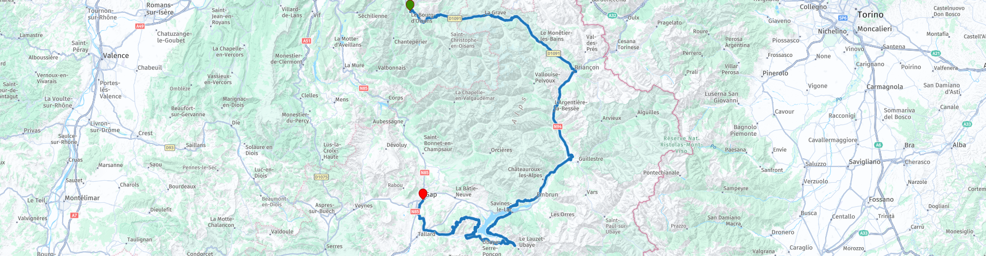
 Route Summary
 Briançon, Embrun and Gap. Others are less visible, such as the mountain villages around the Lac de Serre-Ponçon. But they are all exceptional for their cultural heritage, their panoramas, their hidden treasures. The best thing: they are all easy to visit all year round thanks to free guided tours!
The unique area of the Parc national des Ëcrins is not only characterised by the flora and fauna of the park, but also by its archaeology, built heritage, landscape, peaks and passes, culture, glaciers, lakes and geology. That is why this exploration tour, which also takes you along exciting roads, has been awarded a five-star rating.
 Share this route


Animation

Verdict


Duration
8h 33m

Mode of travel
Car or motorcycle

Distance
234.02 km

Countries

 RouteXpert Review
 In the Musée des Mineraux et de la Faune des Alpes in Bourg d'Oisans you can discover the flora and fauna of the nature park and the Alps. It is also the starting point of this tour through the high Dauphiné.
The town of Le Bourg d'Oisans is an ideal base for discovering some of the most beautiful sites in the Alpes du Dauphiné. It is located at the crossroads of mountain ranges, with the Belledonne to the north, the Écrins to the south and the Maurienne valley to the north-east.
The Bourg d'Oisans valley has been inhabited since ancient times and was used as a trade route from Grenoble to Briançon and beyond over the mountains. In the Middle Ages, there was a castle on this site, but few remains date from that time. The town is now mainly known as a stopover for cyclists who want to conquer one of the nearby Alpine passes or who want to try their hand at the Alpe d'Huez. But there is much more to do in the area, whatever your activity.
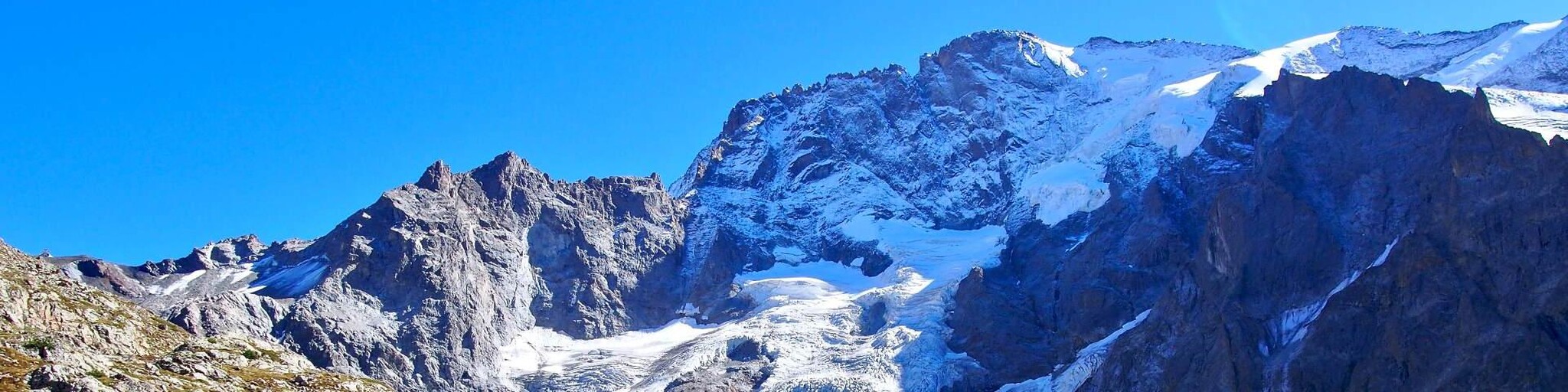
The Jardin Alpin du Lautaret lets you discover the flora of mountain regions worldwide, while enjoying a magnificent view of the peaks of the Meije and Écrins massif. Although it is located at an altitude of 2050 meters, there is a relatively mild climate. Moreover, the valley of La Grave, Villar d'Arène and Monêtier-Les-Bains is rich in flora anyway. No less than 1,500 wild plant species have been counted here. In addition, the garden has another asset: it offers a view of a mountain range where you can clearly see the different layers of the earth from which the Alps were formed.
Briançon is situated at an altitude of 1326 metres, making it the highest city in France. This city is located at the confluence of five valleys and is full of art and history. It is not without reason that Briançon has been designated a UNESCO World Heritage Site. Briançon has a remarkable collection of military buildings that were built between the 17th and 20th centuries to improve the city's defences. This area forms the centre of the city and is characterised by the castle fortress. In addition, there are various surrounding buildings to admire, such as fort Salettes, fort Trois Têtes and fort Randouillet. Once through the gate of Pignerol, you will find a picturesque old town with various testimonies to its past. Architecture enthusiasts can enjoy the 18th century Notre-Dame ler, the 14th century church of the Cordeliers, the old houses along the sloping streets, the pretty Place d'Armes surrounded by beautiful coloured facades, fountains and sundials. Halfway down the Rue de la Mercerie you stop for a coffee break at the Place d'Armes. From under the (reconstructed) canopy of the Kortegaard, which used to shelter soldiers of the Corps de Garde, we have a view of the Provencal-looking facades around the square.
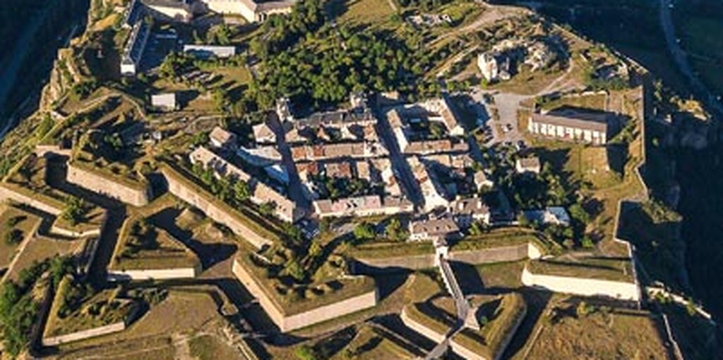
Halfway between Briançon and Embrun, the Guil river flows into the Durance. It was at this point, at the time still close to the border with Italy, that the famous architect Vauban had to build a new fortress at the end of the 17th century. Construction began quickly, but the original plans were never fully implemented. Mont-Dauphin even became one of the fortified towns with the most desertions. Nevertheless, it did end up on the UNESCO World Heritage List, as one of the most important examples of Vauban's architectural skills.
The fort also houses houses, fountains, wash houses and green spaces that invite you to take a walk. Along the ramparts, a beautiful panorama of the mountain landscapes opens up to the gaze of the walkers.
Not to be missed during a visit to Mont-Dauphin are the Rochambeau barracks with their arched staircase and magnificent roof trusses and the Vauban museum, housed in the interior of the arsenal. After visiting the barracks and the arsenal, you must of course visit the large powder magazine behind the arsenal. This is an impressive building, which was very well thought out to reduce the risk of explosions.
Lunch is planned in Embrun. Stretch your legs to explore the town. The cathedral of Notre-Dame-du-Real immediately catches your eye. This majestic religious building (the largest in the French Alps) is inspired by Lombardy and impresses with its 800-year-old history. The architecture is impressive; the pyramid-shaped bell tower is 35 metres high, the porch is richly decorated, the marble is pink and green, the slate is black and the limestone is white. Inside you will find, among other things, a large rose window and a remarkable fresco from the 15th century, elegant transverse vaults and two sights: the Great Organ (donated by Louis XI) and the church treasure of the Sainte-Anne chapel.
The former archbishop's palace was a watchtower, prison, arsenal, hermitage and later a water reservoir for the army in the 12th century. From its 27-metre-high crenellated terrace, you can now enjoy a 360-degree view of the Embrun countryside and the Durance valley. The House of Chanonges or Heritage House of Embrunais (13th century) is the oldest residence in Embrun. Take your time to admire its beautiful Romanesque façade. Once the home of the canons who managed the archbishop's possessions, the building now offers a cultural space, decorated with a coffered ceiling and a mural from centuries ago.
After lunch, you will pass the (artificial) lake of Serre-Ponçon. After a new series of devastating floods, the French state took a drastic decision in the 1950s: the entire valley – including villages, railway lines and viaducts – was simply flooded. This was to put an end to the Durance region once and for all. Voilà, the fascinating history of the creation of the largest reservoir in France, which is now one of the most popular attractions in the Hautes-Alpes. In the middle of the lake, the chapel of Saint Michel, the symbol of Serre-Ponçon, still stands above water. During the construction of the Serre-Ponçon dam in the 1960s, the chapel was intended to be destroyed, but thanks to its location on a hill above the maximum water level, it was able to be preserved. For more history, Le Museoscope du Lac is also highly recommended. The museum was recently completely renovated and takes you through the past of the lake in 6 rooms, including 4D films, in an inventive way. In addition to the museum, you also have a lookout point on the gigantic dam that holds back 1.2 billion cubic meters of water. A good opportunity to take a drink break on the terrace of the adjacent restaurant.
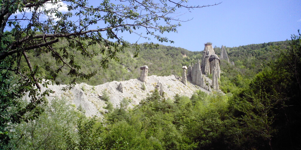
On to a winding path in your route to fully enjoy the "Fairy Chimneys" or "Demoiselles coiffées". They are formed in the soil of glacial moraines, where layers of rock of varying hardness are subjected to the action of wind and water. As the lower, looser layers erode over time, a stronger type of stone protects the sediment column below. This is how these slender silhouettes are created, sometimes more than 20 metres high, crowned with their rocky "headdress". While science explains their geological origins, local traditions give them a mystical dimension. According to legend, there once lived in Theus young girls of dazzling beauty. Because they loved to dance, they met one evening in the Vallon de Vallauria for a last farandole, wearing large, flat hats. But when midnight came near the church of Theus, a devilish howl resounded through the valley. In the blink of an eye, the young dancers were forever petrified and transformed into tall stone columns with headdresses. Since that day, they have stood motionless and silent over the valley, like witnesses to a tragic fate.
Then you soon approach the final destination Gap, best known as one of the cities through which Napoleon passed on his way to Paris, after returning from Elba in 1815: the Route Napoleon is an undiminished popular route. Gap still has a reasonably preserved historical centre. Be sure to visit the cathedral, the home of the bishop of the city, last renovated at the end of the 19th century. With its pastel facades, its shopping streets and mountain landscape, Gap, as the capital of the Hautes-Alpes, has a good asset to enjoy this trip somewhere.
 Links
Links  Usage
Usage Want to download this route?
You can download the route for free without MyRoute-app account. To do so, open the route and click 'save as'. Want to edit this route?
No problem, start by opening the route. Follow the tutorial and create your personal MyRoute-app account. After registration, your trial starts automatically.  Disclaimer
Use of this GPS route is at your own expense and risk. The route has been carefully composed and checked by a MyRoute-app accredited RouteXpert for use on TomTom, Garmin and MyRoute-app Navigation.
Changes may nevertheless have occurred due to changed circumstances, road diversions or seasonal closures. We therefore recommend checking each route before use.
Preferably use the route track in your navigation system. More information about the use of MyRoute-app can be found on the website under 'Community' or 'Academy'.

Provence Alpes Cote d Azur
About this region
Provence-Alpes-Côte d'Azur (French pronunciation: [pʁɔvɑ̃s‿alp kot d‿azyʁ]; Occitan: Provença-Aups-Còsta d'Azur, [pɾuˈvɛnso̞ ˈawps ˈkɔsto̞ daˈzyɾ], or Provença-Alps-Còsta d'Azur, [pɾuˈvɛnso̞ ˈalps ˈkɔsto̞ daˈzyɾ]; commonly shortened to PACA; English: Provence-Alps-French Riviera; also known as Région Sud) is one of the eighteen administrative regions of France, the far southeastern on the mainland. Its prefecture and largest city is Marseille. The region is roughly coterminous with the former French province of Provence, with the addition of the following adjacent areas: the former papal territory of Avignon, known as Comtat Venaissin; the former Sardinian-Piedmontese County of Nice, whose coastline is known in English as the French Riviera and in French as the Côte d'Azur; and the southeastern part of the former French province of Dauphiné, in the French Alps. Previously known by the acronym PACA, the region adopted the name Région Sud as a commercial name or nickname in December 2017. 5,007,977 people live in the region according to the 2015 census.
It encompasses six departments in Southeastern France: Alpes-de-Haute-Provence, Alpes-Maritimes, Bouches-du-Rhône, Hautes-Alpes, Var and Vaucluse. It is bounded to the east by the France–Italy border, to the south by the Mediterranean Sea and by the Principality of Monaco, to the north by Auvergne-Rhône-Alpes and to the west by Occitanie, with the Rhône marking its westernmost border. The region logotype displays the coat of arms created in the 1990s and which combines the coats of arms of the old provinces making up Provence-Alpes-Côte d'Azur. The region's economy is the third largest in France, just behind Île-de-France and Auvergne-Rhône-Alpes. Its GDP in 2012 was €142.4 billion (US$183.1 billion) while its per capita GDP was €28,861 ($US 37,121).
Read more on Wikipedia
It encompasses six departments in Southeastern France: Alpes-de-Haute-Provence, Alpes-Maritimes, Bouches-du-Rhône, Hautes-Alpes, Var and Vaucluse. It is bounded to the east by the France–Italy border, to the south by the Mediterranean Sea and by the Principality of Monaco, to the north by Auvergne-Rhône-Alpes and to the west by Occitanie, with the Rhône marking its westernmost border. The region logotype displays the coat of arms created in the 1990s and which combines the coats of arms of the old provinces making up Provence-Alpes-Côte d'Azur. The region's economy is the third largest in France, just behind Île-de-France and Auvergne-Rhône-Alpes. Its GDP in 2012 was €142.4 billion (US$183.1 billion) while its per capita GDP was €28,861 ($US 37,121).
View region
 Statistics
  59
59Amount of RX reviews (Provence Alpes Cote d Azur)
 54198
54198Amount of visitors (Provence Alpes Cote d Azur)
 3721
3721Amount of downloads (Provence Alpes Cote d Azur)
 Route Collections in this region
 The 24 Most Beautiful Alpine Routes
The Alps, The Alps are a mountain range in Europe, stretching from the French Mediterranean coast in the southwest to the Pannonian Plain in the east. The area of the mountain range is more than 200,000 km².
In other words Passes and Mountain Roads!
Driving through the mountains is great! Especially over the mountain passes with hairpin bends and narrow winding roads. Every bend a different view where you can enjoy. There are many beautiful mountain passes in the Alps.
A selection that has also been incorporated into these routes:
The Stlevio Pass:
The Stelvio Pass, also known as Passo dello Stelvio, is mainly known for the stage in the Giro d'Italia. Due to the length and the difference in height, this pass is seen as one of the toughest tests in cycling. The Stelvio Pass reaches a maximum height of 2758 meters and is therefore one of the highest in the Alps. The pass connects the towns of Bormio and Prato Allo Stelvio. In winter the pass is closed due to heavy snowfall.
The Reschenpass:
The Reschenpass, also known as Passo di Resia, connects the Austrian state of Tyrol with the Italian province of South Tyrol. The pass reaches a maximum height of 1,504 meters and has been one of the most important north-south connections in the Alps in recent centuries. The pass was used long before Roman times. Along the way you will pass several highlights and historical relics. One of the highlights is the Reschensee. This lake was created after the construction of the dam and has completely submerged the village of Graun. The only thing that reminds of that is the clock tower in the middle of the lake.
Col du Galibier:
The French mountain pass Col du Galibier connects the towns of Saint-Michel-de-Maurienne and Briançon via the Col du Lautaret in the south and the Col du Télégraphe in the north. The mountain pass is part of the Tour de France and very much feared, due to the fact that it can only be reached via the other two mountain passes. The pass reaches a maximum height of 2646 meters. From there you can take a walk to the viewpoint at 2704 meters. You can admire the peaks of the Grand Galibier, Mont Blanc and La Meije here.
The Grossglockner High Alpine Road:
With a height of 3798 meters the Grossglockner is the highest mountain in Austria. To fully enjoy this impressive mountain, you can drive over the Grossglockner High Alpine Road and the accompanying pass. The route starts from Bruck am Grossglockner and ends in Heiligenblut. Of course you can drive in two directions. The pass reaches a maximum height of 2504 meters and is closed in winter due to heavy snowfall. Along the way you pass several stops with fun activities, information points, mountain huts and viewpoints. A visit to the Kaiser-Franz-Josefs-Höhe and Pasterzen Glacier is highly recommended.
The Col d'Izoard:
Just like the Col du Galibier, the Col d'Izoard is also part of a stage of the Tour de France. The mountain pass connects Briançon with the valley of the river Guil. The pass is partly located in the Regional Natural Park du Queyras and reaches a maximum height of 2360 meters. What is special about the Col d'Izoard is the barren and rocky landscape. Sometimes it feels like driving a car over the moon! Along the way you can stop at several points to enjoy the beautiful view.
The Bernina Pass:
The Bernina Express is one of the most famous rail trains in Switzerland and the Alps. The route is beautiful and partly included on the UNESCO World Heritage List. Parallel to the railway lies the Bernina pass, which connects the Veltlin valley with the Egandin valley. This beautiful Alpine road has a total length of 56 kilometers and reaches a maximum height of 2328 meters. Along the way you can enjoy views of the Morteratsch Glacier.
The Sella Pass:
The Sella Pass, also known as Passo di Sella, takes you over one of the most impressive mountain ranges in the Dolomites: the Sella massif. The pass connects Valle di Fassa with Val Gardena and reaches a maximum height of 2236 meters. At this height is also the border of the Italian provinces of Trentino and Bolzano. Along the way you can enjoy the view of this spectacular mountain world. Admire, for example, the three peaks of the Sasso Lungo massif, the Sella massif or the peaks of the Marmolada. You can also drive the Sella pass in combination with the Gardena pass, Pordoi pass and Campolongo pass.
The Grimsel Pass:
The Grimsel Pass connects Goms in Wallis with the Halis Valley in the Bernese Oberland. The pass reaches a maximum elevation of 2165 meters and is closed in winter due to snowfall. Over the centuries, the mountain pass has played an important role in trade between Switzerland and Italy. Now it is mainly the reservoirs that have an important function. These are used to generate electricity. The landscape you drive through is rugged, rocky and impressive. On top of the pass is a hotel and a restaurant with a special marmot park. The Dodensee (Totensee) is also located here. This lake owes its name to the many soldiers who died in the time of Napoleon.
The Gotthard Pass:
The Gotthard Pass, also known as Passo del San Gottardo and Saint Gotthard, connects the Swiss towns of Airolo and Andermatt. The mountain pass and associated tunnel are especially known among holidaymakers driving from Switzerland to Italy. But where the majority opt for the tunnel, it is precisely the pass that really completes the holiday. The Gotthard Pass has a length of about 26 kilometers and reaches a maximum height of 2106 meters. The route is beautiful and takes you along old villages and beautiful views.
The Silvretta High Alpine Road and Silvretta Pass:
The Paznaun Valley in Tyrol and the Montafon in Vorarlberg are connected by the Silvretta High Alpine Road. The route has a length of 22.3 kilometers and leads from Galtür to Partenen in 34 hairpin bends, via the 2032 meter high Bielerhöhe. The Silvrettasee is also located at this point, where you can enjoy a lovely walk. The pass is closed in winter due to snowfall.
The Simplon Pass:
Just like the Gotthard Pass, many holidaymakers also travel over the Simplon Pass every year. This mountain pass connects the Rhone Valley in the canton of Valais with the Valle d'Ossola in Piemonte. The pass is open all year round and reaches a maximum height of 2005 meters. Along the way you pass a number of buildings, including the well-known Simplon Hospiz from 1825. The hospiz is managed by the monks of St. Bernard. From the highest point on the pass, all kinds of hiking routes are possible and you will also come across a hotel where you can spend the night.
The Gerlos Pass:
The Gerlos Pass connects the Salzach Valley in the Salzburgerland with the Zillertal Valley in Tyrol. The pass is part of the Gerlos Alpenstraße and runs right through the Hohe Tauern National Park. Along the way you can enjoy beautiful views of the surroundings. The pass has a length of 12 kilometers and reaches a maximum height of 1531 meters. A ride over the Gerlos Pass can be ideally combined with a visit to the Krimmler Wasserfälle.
The Great St. Bernard Pass:
The Great St. Bernard Pass, better known as Col du Grand Saint Bernard, connects the Italian province of Valle d'Aosta with the Swiss canton of Valais. The pass is one of the highest in Switzerland and reaches a maximum height of 2469 meters. Like a number of other mountain passes in this list, the Great St. Bernard Pass has also been used as a connecting road for centuries. The pass is named after the St. Bernard dogs that used to help stranded travelers along with the monks. The pass is closed in winter.
The Timmelsjoch High Alpine Road:
The Timmelsjoch High Alpine Road connects the towns of Sölden in the Ötztal and Meran in South Tyrol. Tolls must be paid on the Hochgurgl - Moos route. Via a mountain road with about 60 hairpin bends you drive through a beautiful mountain world. With the Timmelsjoch Experience you can learn more about the history, the road and the environment via various stations. You can also visit the Top Mountain Crosspoint museum.
Col de l'Iseran:
With a maximum pass height of 2770 meters, the Col l'Iséran is one of the highest mountain passes in the Alps. The pass connects Bourg-Saint-Maurice with Bonneval-sur-Arc. Via a road full of hairpin bends you pass, among other things, Val-d'Isère and a side valley of the Maurienne that lies entirely in the National Park de la Vanoise. You can spot animals such as marmots and chamois and there is also a restaurant with a chapel on top of the pass.
The Gavia Pass:
The Gavia Pass (Italian Passo di Gavia) is a mountain pass in the Italian Alps, in the Lombardy region.
It is one of the highest pass roads in Europe. The road leads through the unspoilt Stelvio National Park. The road was built in the First World War to supply Italian soldiers who fought in the Italian-Austrian border area. The pass height is one of the most beautiful in the Alps. Here is the large Lago Bianco with, to the north, the mountain San Matteo (3684 meters). Lago Nero is slightly lower on the south side of the pass. Here the mountain group of the Adamello determines the view. There are many well-marked walks in the area. During the winter the pass is closed due to the heavy snowfall. The pass is often closed until May and June due to the large amount of snow.
Promoter has made a selection of the 24 Most Beautiful Alpine routes that they have set out in recent years.
The routes go through:
France
Austria
Switzerland
Italy
The most beautiful roads, the most beautiful views, the most beautiful viewpoints. The highest mountains, the fastest descents, hairpin bend after hairpin bend, you name it you can't get enough of it.
If you go on holiday in this region, take advantage of it, ALL routes in this collection have been checked and made equal for TomTom, Garmin and MyRoute-app Navigation by a MyRoute-app RouteXpert.
Have fun with this collection and while driving one of these routes. Enjoy all the beauty that the Alps and the Dolomites have to offer. Click on “View route” to read the review of the chosen route.
I would like to hear your findings about the route(s).
View Route Collection
25 Magnificent trails in France
This MRA route collection contains 25 beautiful motorcycle routes in different parts of France, such as the Ardennes, the Alsace, Vercors, the Drôme, the Ardèche, Cote d'Azure, Gorges du Verdon, the Ariège, the Dordogne and Brittany.
The routes have been carefully created by Bert Loorbach, who is an enthusiastic motorcyclist himself. He lived in France for a year and a half, during which time he devoted himself to mapping the unknown and beautiful back roads of France especially for motorcyclists.
The routes are bundled in the Motortourgids France part 1 of Kosmos publishing house and now also available in MyRouteApp.
I have taken over the routes in MRA and sometimes adjusted them slightly to make them even more interesting for the motorcyclist.
View Route Collection