Slavonia from Osijek

This route was brought to you by:
RouteXpert Jan Koelstra - Senior Rx
Last edit: 18-07-2025
 Route Summary
 A great way to explore this region is by following the Slavonia routes. Driving along these routes, you'll encounter unspoiled river landscapes as well as Slavonia's cultural highlights. This offers a unique opportunity to experience Croatia authentically, away from the hustle and bustle of popular coastal destinations. While the predominantly flat landscape sometimes offers little variety, enhanced by the large plots of land dedicated to agriculture and viticulture, this is more than compensated for by the combination of rich folk culture, traditional villages, meadows, marshes and forests, and delicious cuisine. It makes this region a must-see destination. This adventure has therefore received a four-star rating.
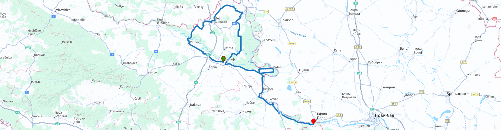
Whether you're looking for peace and relaxation or adventure and discovery, Slavonia has it all. This route begins in Osijek and ends in Ilok; it runs through the Baranja region, through Kopački Rit Nature Park, and then along the border with Serbia.
 Share this route


Animation

Verdict


Duration
7h 57m

Mode of travel
Car or motorcycle

Distance
229.28 km

Countries


 RouteXpert Review
 The rivers here make the soil incredibly fertile and ideal for wine production. Slavonia is therefore one of Croatia's most famous wine regions, and a visit to one of the many wineries is a must. Slavonia also has a lot to offer culinary-wise, as the famous Kulen wines originate here. To experience authentic Slavonian cuisine, you can sample many other local dishes in addition to Kulen wines at one of the small, authentic restaurants found throughout the region. There's plenty to do in Slavonia!
This route through Slavonia begins in the city of Osijek on the Drava River. Osijek is a cozy, lively city with a rich history and impressive architecture. From Osijek, you can drive straight into the rolling Slavonian countryside. Besides rivers and forests, you'll also encounter charming villages and interesting sights.
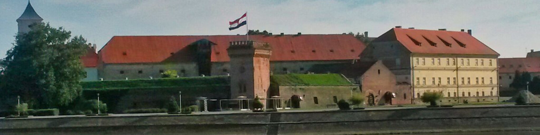
Osijek has a beautiful old town, an impressive fortress (Tvrđa), a magnificent cathedral, a striking pedestrian bridge, and interesting museums. Start with a visit to the fortress and/or the cathedral. Parking nearby with your motorcycle or car is difficult.
During the 1991 war, Osijek once again experienced the disadvantages of its strategic location. Thanks to Vukovar's resistance, the city avoided occupation by the federal army, but for more than a year, Osijek was heavily bombarded from the left bank of the Drava River, where the Serbs had positioned themselves after capturing Baranja.
Valpovo is one of the oldest Slavonian towns and one of the few with preserved material heritage from the medieval period. In the 18th and 19th centuries, the Baroque-Classical castle of the von Prandau family was built here, following the example of the medieval fortress. An interesting architectural blend of styles and eras from the early 19th century is also enhanced by a large English-style park. Here you can stop for a coffee and perhaps combine it with a visit to the castle, as the town has many coffee shops.
Belišće isn't just about factory chimneys and steam engines. The trigger selfie in front of the prestigious palace of the same name will prove that the Gutmanns did a good job here. The workers lived a much more modest life, which you can best experience when you visit the street with its seven preserved workers' houses from the late 19th century.
After Belišće, you cross the Drava River and enter the Baranja region, which extends largely into Hungary. The Croatian part of Baranja is an agricultural landscape, wine and hunting region, and the eastern part along the Danube is primarily a very marshy area. Here, on the Danube, in the border region between Croatia and Serbia, several mini-states were formed for ideological reasons after the Balkan War (1990). Several still exist today, such as Liberland and Verdis. They are thwarted by Croatia and therefore have limited access. Kopački Rit Nature Park is also located here.
Tikveš Castle is a complex surrounded by a forest park with several buildings: a new castle with an annex, an old castle, a chapel, and other facilities including a restaurant. Throughout history, the castles served as hunting grounds for guests of the court and princes, and they became famous throughout Europe and the world. Today, Tikveš Castle has been reconstructed, furnished, and converted into an information center aimed at educating visitors about nature parks.
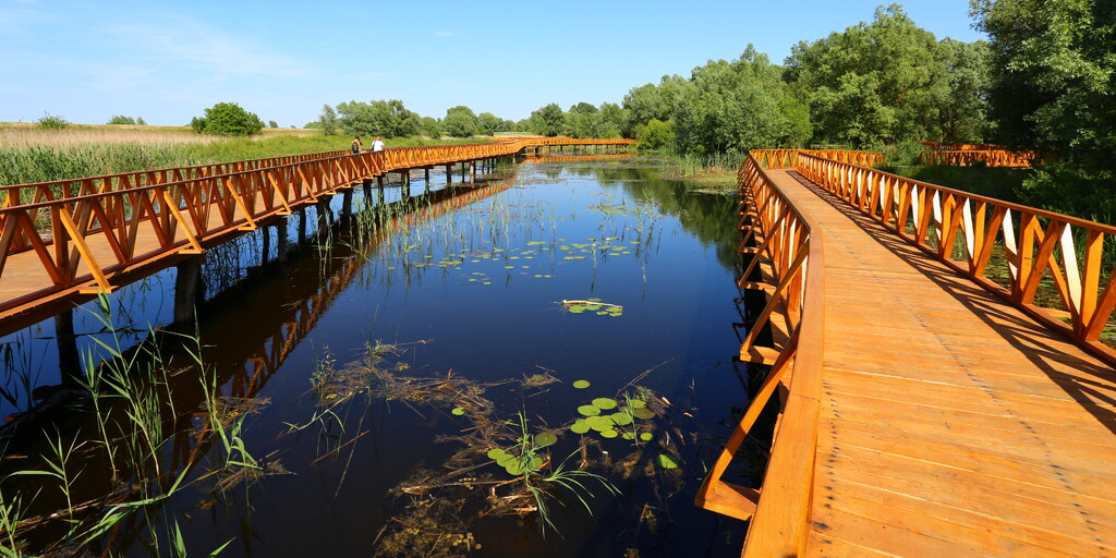
Kopački Rit Nature Park is one of the most beautiful places in all of Slavonia. This wetland area comprises a cluster of lakes and marshes where the Danube and Drava rivers meet. It covers almost 180 km² and boasts a rich flora and fauna, including tens of thousands of birds representing several hundred different species. It is one of the largest wetlands in all of Europe and is a UNESCO World Heritage site. There is a walking trail through the park with wooden walkways and bridges, and you can also take a guided boat trip. Visitors can go birdwatching, take a canoe tour, or rent bicycles. There are also educational programs and an interactive exhibition.
Via Bilje, where the elite built a hunting lodge at the beginning of the 18th century, you leave Baranje again via the large bridge over the Drava River and follow the river east. The fortified village of Erdurt lies in a meander.
Grapevines, a castle on a hill with the mighty Danube in the background. And all of that in a single view. What more could you need? This is Erdut, one of the oldest wine regions in Slavonia. Here you can walk to the medieval towers, remnants of the old city destroyed by the Danube in ancient times. The landscape of the Danube meander in the Erdut municipality is a protected landscape. Here you can visit the Erdut Vineyards winery, which houses one of the largest wine barrels in Europe, with a capacity of 75,000 liters, made of Slavonian oak. The vine has been cultivated and worshipped here since the time of the Roman Empire. The Erdut Agreement was signed in Adamovich-Cseh Castle on November 12, 1995, which led to the end of the war in eastern Croatia.
The next village is Aljmaš, which means "apple" in Hungarian. In the center of the village is the Marian Shrine of Our Lady of Refuge, and not far from the village lies the mouth of the Drava River into the Danube. The path takes you along a panoramic road and up the crest of a small hill through orchards and vineyards.
The Baroque town of Vukovar is also worth a visit. It lies at the confluence of the Danube and Vuka rivers. This is also the heart of Croatian independence, having played a significant role in the war of the 1990s. Fortunately, the town has since regained its old charm. You'll find many interesting sights there. As you leave the town towards Ilok, you'll find the famous water tower on the left. Before the war, a revolving restaurant was located at the top of this water tower. Now it's a symbol of the city's resistance. During the siege, the Croatian flag was raised here every day. Every day, the besiegers shelled the tower. Now, the flag can fly freely, but it's a miracle that this structure is still standing. The Vukovar Memorial Center, a cemetery and memorial, is located 1 km south towards Llok, on the right side of the road, and contains the remains of over a thousand victims of the siege and occupation of the city. Some graves are unmarked.
Don't miss the Vučedol Cultural Museum. This museum is built on an archaeological site where the Vučedol people lived 3,000 years before Christ. They were among the first peoples in Europe to make a living from agriculture. In the museum, you'll find not only artifacts but also skeletons, in their original locations.
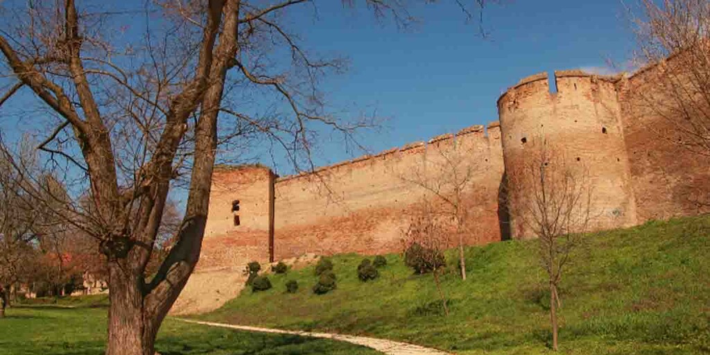
The end point of your route is Ilok, a fortified town on a bend in the Danube River, with a castle and museum housed in a magnificent building. It is located on the border with Serbia. In the Middle Ages, Ilok was a castrum, a town with high walls, towers, and fortifications. In the 15th century, a church and monastery were built in the fortress, dedicated to St. Ivan Kapistran. In the 16th century, Ilok became an important administrative and military center for the Turks, who added Turkish baths and mosques to the fortress. It is the longest military fortification system preserved in continental Croatia, measuring almost 1.5 kilometers. The church and monastery were recently renovated. A section of the walls between these two buildings has been preserved and can still be seen today. The old wine cellars near the castle are famous throughout Croatia; Ilok wines are produced there, especially the dry white Traminec. After this trip, it must taste good!
 Links
Links  Usage
Usage Want to download this route?
You can download the route for free without MyRoute-app account. To do so, open the route and click 'save as'. Want to edit this route?
No problem, start by opening the route. Follow the tutorial and create your personal MyRoute-app account. After registration, your trial starts automatically.  Disclaimer
Use of this GPS route is at your own expense and risk. The route has been carefully composed and checked by a MyRoute-app accredited RouteXpert for use on TomTom, Garmin and MyRoute-app Navigation.
Changes may nevertheless have occurred due to changed circumstances, road diversions or seasonal closures. We therefore recommend checking each route before use.
Preferably use the route track in your navigation system. More information about the use of MyRoute-app can be found on the website under 'Community' or 'Academy'.

Vojvodina
About this region
Vojvodina ( voy-vuh-DEE-nə) is an autonomous province that occupies the northernmost part of Serbia. It lies within the Pannonian Basin, bordered to the south by the national capital Belgrade and the Sava and Danube Rivers. The administrative center, Novi Sad, is the second-largest city in Serbia.
The historic regions of Banat, Bačka, and Syrmia overlap the province. Modern Vojvodina is multi-ethnic and multi-cultural, with some 26 ethnic groups and six official languages. About two million people, nearly 27% of Serbia's population (excluding Kosovo), live in the province.
Read more on Wikipedia
The historic regions of Banat, Bačka, and Syrmia overlap the province. Modern Vojvodina is multi-ethnic and multi-cultural, with some 26 ethnic groups and six official languages. About two million people, nearly 27% of Serbia's population (excluding Kosovo), live in the province.
View region
 Statistics
  1
1Amount of RX reviews (Vojvodina)
 428
428Amount of visitors (Vojvodina)
 0
0Amount of downloads (Vojvodina)
 Route Collections in this region
 Slavonia you know
Have you ever heard of Slavonia? It's located in the northeasternmost tip of Croatia, where the country borders Hungary, Serbia, and Bosnia. Here, where the three major rivers—Drava, Sava, and Danube—flow, a beautiful region lies hidden. This relatively unknown part of Croatia boasts a rich history, culture, and natural beauty.
This collection consists of a series of four connected rides, spread across Slavonia.
Your first ride starts in Osijek and ends in Ilok; it runs through the Baranja region, through the Kopački Rit Nature Park and then following the Danube along the border with Serbia.
The second route starts in Ilok, goes through the Syrmia region, along the border with Serbia and then via Vinkovci ending in the cathedral town of Dakovo.
The third route starts in Dakovo and ends in Požega; it runs along the border with Bosnia, through the Kutjevo wine region and then through Papuk Nature Park.
The fourth route starts in Požega, runs through the Papuk Geological Nature Park, then follows the meandering Drava River on the border with Hungary via the Križnica area, visits a stud farm and finally ends in Našice.
A great way to explore this region is by following the "Slavonia you know" routes. Driving along these routes, you'll encounter unspoiled river landscapes as well as Slavonia's cultural highlights. This offers a unique opportunity to experience Croatia authentically, away from the hustle and bustle of popular coastal destinations. While the predominantly flat landscape sometimes offers little variety, enhanced by the large plots of land dedicated to agriculture and viticulture, this is more than compensated for by the combination of rich folk culture, traditional villages, meadows, marshes, forests, and delicious cuisine, making this region a destination not to be missed.
View Route Collection