
Rhone Valley from Grignan

This route was brought to you by:
RouteXpert Jan Koelstra - Senior Rx
Last edit: 31-10-2025
 Route Summary
 The Rhône region is usually divided into the northern and southern parts. Wines from the northern part, where Syrah dominates, are therefore quite different from those from the southern part, where Grenache Noir is the dominant grape. The southern Rhône region accounts for 80% of the total wine production of the entire Rhône Valley, but is also much more extensive than the northern part.
Because the southern part is so extensive, several routes have been set out.
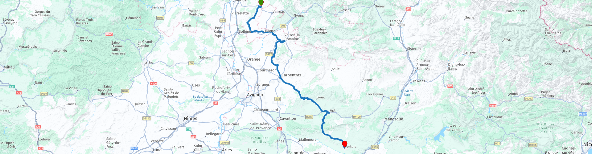
This route explores the southeastern part of the Côtes du Rhône. It begins in Grignan and ends in Pertuis in the Luberon.
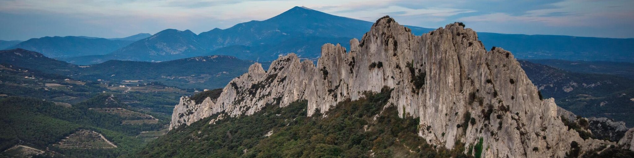
Numerous wine-growing towns and villages host wine tastings. There's also plenty to see, and the route's roads weave through the vineyards, offering glimpses of the daily work in the wine industry. Enjoy the famous vineyards, picturesque villages, and stunning scenery, such as the Dentelles de Montmirail and Mont Ventoux. The diverse landscapes make the tour a fantastic driving experience, worthy of a five-star rating!
 Share this route


Animation

Verdict


Duration
4h 33m

Mode of travel
Car or motorcycle

Distance
158.01 km

Countries

 RouteXpert Review
 You've undoubtedly seen Côtes du Rhône and Côtes du Rhône Villages on supermarket shelves. They are the two major appellations of the southern Rhône Valley, between Montélimar and Avignon. Côtes du Rhône Villages is the better of the two in terms of quality: these wines come from communes with a better terroir, meaning a better mix of natural factors (microclimate, topography, soil composition, etc.) that results in better grapes and therefore better wine.
In the past, Châteauneuf-du-Pape, Gigondas, Vacqueyras, and Lirac distinguished themselves from other communes. Due to their superior terroir, they became separate appellations and were only allowed to use their own commune name on their labels. Gradually, new communes were also able to break away from the pack: they obtained the right to add their commune name to the generic appellation of Côtes du Rhône Villages.
Because the southern part is so extensive, several routes have been set out.
This route explores the southeastern part of the Côtes du Rhône. It begins in Grignan and ends in Pertuis in the Luberon.
Grignan
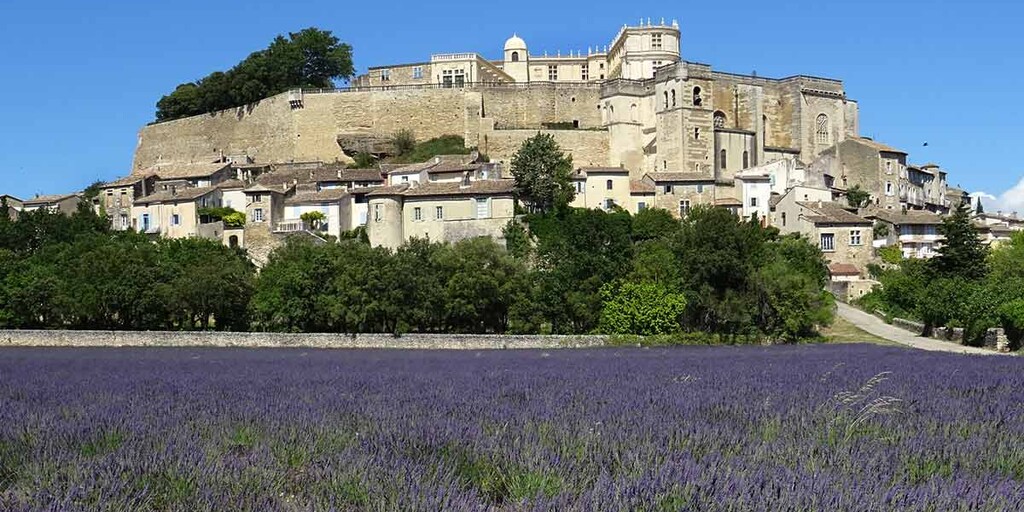
Grignan is built on a hill, offering beautiful views of the region, where you can see and smell fields of lavender, among other things. At the top of the hill stands the castle, built in the early 11th century as a military fortress. The historical connection between the castle and village buildings is strikingly illustrated in Grignan, where the houses climb up to a castle considered one of Provence's Renaissance giants. The former truffle town of Grignan now focuses partly on wine, although the castle also generates revenue from tourism. The streets and squares of the village itself are also a definite reason to visit Grignan. There are many photogenic spots within the village, and those who enjoy views can enjoy a panoramic view of the surrounding area from the plateau in front of the castle.
Grignan gives its name to the Grignan-les-Adhémar wine region (formerly Côteaux du Tricastin). The region is located in the Drôme department between Montélimar, Grignan, and Suze-la-Rousse.
Suze-la-Rousse
Located in the heart of the Rhône Valley vineyards, the château houses the University of Wine's experimental garden. The facility, with its laboratories and tasting rooms, is unique in Europe and offers courses in oenology, marketing, and management for the wine industry.
Like Grignan, the old buildings of Suze-la-Rousse are also overshadowed by a castle whose architecture is closed and medieval. Surprisingly, at its heart stands a charming, open-plan Italianate courtyard from the 16th century. This castle houses a wine university, a research institute that has achieved international renown. The Princes of Orange had this colossal building built on a hill as early as the 12th century.
Vaison-la-Romaine (coffee stop)
Vaison-la-Romaine lies northwest of the renowned wine and Tour de France mountain, Mont Ventoux. The Tuesday market clearly demonstrates that this fruit and wine town has a very large catchment area. You can easily spend an entire day in Vaison-la-Romaine, as you visit four towns simultaneously: the modern one, built on and next to a much older Roman town; and on the left bank of the Ouvèze, the medieval Haute Ville, which in turn was built on the oldest settlement, a Celtic oppidum. A large parking lot near the tourist office separates the two Roman sites, Villasse and Puymin. On the horizon, next to Mont Ventoux, you can see the spiky Dentelles de Montmirail massif.
The villages that follow on the route all have their own terroir and thus their own appellation. This is the region where the Côtes du Rhône Villages wine is prevalent.
The hilltop village of Seguret stands out against the slopes of the Dentelles de Montmirail. The famous surrounding vineyards add a touch of greenery. The village's medieval character is best explored by strolling through the cobbled streets lined with old houses.
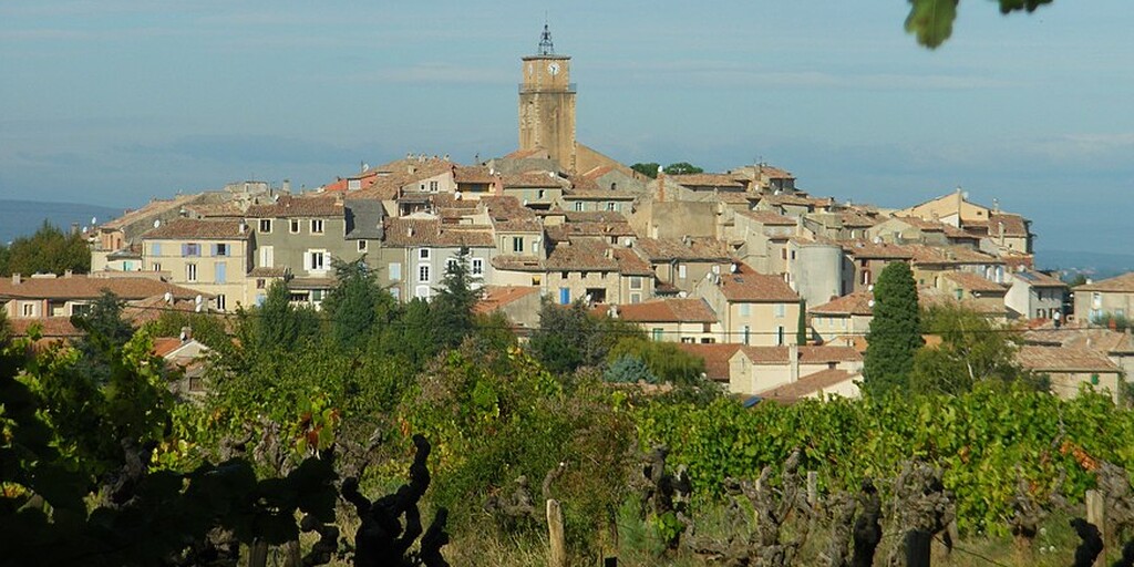
In the small, circular village of Sablet, the streets and houses form a spiral around the church. There is no castle in Sablet because it never depended on feudal lords, but directly on the Papacy. Nevertheless, the village was embellished with a rampart in the fourteenth century.
Gigondas has also secured its own Rhône wine appellation. The numerous wine-tasting cellars build on an ancient tradition. The Roman Pliny already spoke of the vineyards of Gigondas. The bishops of Orange redeveloped the vineyards from the 14th century onward.
The neighboring village of Vacqueyras also has its own appellation. A narrow road leads into the hills to Montmirail, a small spa town whose remains of baths, casino, hotel, and stables nostalgically recall the 19th century, when around 1,000 spa-goers visited Montmirail annually.
Beaumes de Venise lies at the foot of the Courens plateau and owes its name to the numerous caves ("beaumes") dug into the hillside. It's a beautiful place to live. The village is known for its Muscat, a naturally sweet wine, as well as its red wine. If you're interested in wine, be sure to visit the vineyards and cellars.
Between Beaumes de Venise, Vacqueyras, Gigondas, and Lafare lies a tiny mountain range with a unique name: Dentelles de Montmirail. "Dentelles" means something like lacework. The mountain range consists of three rows of limestone, carved and chiseled by erosion. Between each row are protected valleys with vineyards.
Carpentras (lunch stop)
You'll leave the Côtes du Rhône Villages region as you drive to Carpentras for lunch. You'll now arrive in the (Côtes du) Ventoux, the easternmost appellation of the southern Rhône region, named after Mont Ventoux.
Today, Carpentras is a bustling market town of regional importance. In the Middle Ages, Carpentras was a large and important city, even the residence of popes, and therefore many traces of this glorious past can still be found in and around the city center. Here you can encounter elegant ochre-colored facades, charming streets, fountains, and charming squares. The Carpentras synagogue, built in 1367 under the pontificate of Avignon, is the oldest synagogue in France still in use. At that time, there was a large Jewish community there, as after the persecutions of the French kingdom, the city served as a refuge under the protection of the Pope.
After lunch, you'll leave Carpentras and head east towards Apt. The Côtes du Ventoux give way to the Côtes du Luberon, in the far southeastern corner of the Rhône region in Provence. This beautiful wine region nestles among the rolling hills of the Luberon. The vineyards of small winegrowers are located at altitudes ranging from 200 to 400 meters. This hilly area enjoys a Mediterranean climate, creating ideal conditions for grape growth.
Apt (drink stop)
The charming Provençal town of Apt, formerly a Roman military base, is considered the capital of the Luberon region and the world's leading producer of candied fruit. Apt, with its fascinating historic center, is situated near the Luberon Mountains. The narrow streets of the old town are irresistible: the ancient fountains, imposing mansions, and shady squares create a picturesque backdrop. In the heart of the old town, you'll find the 11th-century Sainte-Anne Cathedral, the city's most remarkable monument. It was built on an island between two branches of a now completely dry river.
Pertuis (end point)
Pertuis comes from the Latin word pertus, meaning "transit." And it's true that Pertuis is indeed a transit point between the sea and the mountains, from the Mediterranean to the Vaucluse and the Alps. Exploring the old town is a delight. Stroll through the narrow, flower-filled streets and admire the old houses with their undeniable charm. A visit to the 15th-century Saint-Nicolas Church is definitely worth it, if only to admire the monumental organ. The Saint-Jacques Tower is the only remaining of the seven towers of the 14th-century ramparts. The 12th-century belfry, the only remnant of the castle, now houses Pertuis's local tourist office. The former 16th-century Carmelite convent, one of the town's most prestigious monuments, now houses a media library.
 Links
Links  Usage
Usage Want to download this route?
You can download the route for free without MyRoute-app account. To do so, open the route and click 'save as'. Want to edit this route?
No problem, start by opening the route. Follow the tutorial and create your personal MyRoute-app account. After registration, your trial starts automatically.  Disclaimer
Use of this GPS route is at your own expense and risk. The route has been carefully composed and checked by a MyRoute-app accredited RouteXpert for use on TomTom, Garmin and MyRoute-app Navigation.
Changes may nevertheless have occurred due to changed circumstances, road diversions or seasonal closures. We therefore recommend checking each route before use.
Preferably use the route track in your navigation system. More information about the use of MyRoute-app can be found on the website under 'Community' or 'Academy'.
Changes may nevertheless have occurred due to changed circumstances, road diversions or seasonal closures. We therefore recommend checking each route before use.
Preferably use the route track in your navigation system. More information about the use of MyRoute-app can be found on the website under 'Community' or 'Academy'.
 Nearby routes
Provence Alpes Cote d Azur
About this region
Provence-Alpes-Côte d'Azur (French pronunciation: [pʁɔvɑ̃s‿alp kot d‿azyʁ]; Occitan: Provença-Aups-Còsta d'Azur, [pɾuˈvɛnso̞ ˈawps ˈkɔsto̞ daˈzyɾ], or Provença-Alps-Còsta d'Azur, [pɾuˈvɛnso̞ ˈalps ˈkɔsto̞ daˈzyɾ]; commonly shortened to PACA; English: Provence-Alps-French Riviera; also known as Région Sud) is one of the eighteen administrative regions of France, the far southeastern on the mainland. Its prefecture and largest city is Marseille. The region is roughly coterminous with the former French province of Provence, with the addition of the following adjacent areas: the former papal territory of Avignon, known as Comtat Venaissin; the former Sardinian-Piedmontese County of Nice, whose coastline is known in English as the French Riviera and in French as the Côte d'Azur; and the southeastern part of the former French province of Dauphiné, in the French Alps. Previously known by the acronym PACA, the region adopted the name Région Sud as a commercial name or nickname in December 2017. 5,007,977 people live in the region according to the 2015 census.
It encompasses six departments in Southeastern France: Alpes-de-Haute-Provence, Alpes-Maritimes, Bouches-du-Rhône, Hautes-Alpes, Var and Vaucluse. It is bounded to the east by the France–Italy border, to the south by the Mediterranean Sea and by the Principality of Monaco, to the north by Auvergne-Rhône-Alpes and to the west by Occitanie, with the Rhône marking its westernmost border. The region logotype displays the coat of arms created in the 1990s and which combines the coats of arms of the old provinces making up Provence-Alpes-Côte d'Azur. The region's economy is the third largest in France, just behind Île-de-France and Auvergne-Rhône-Alpes. Its GDP in 2012 was €142.4 billion (US$183.1 billion) while its per capita GDP was €28,861 ($US 37,121).
Read more on Wikipedia
It encompasses six departments in Southeastern France: Alpes-de-Haute-Provence, Alpes-Maritimes, Bouches-du-Rhône, Hautes-Alpes, Var and Vaucluse. It is bounded to the east by the France–Italy border, to the south by the Mediterranean Sea and by the Principality of Monaco, to the north by Auvergne-Rhône-Alpes and to the west by Occitanie, with the Rhône marking its westernmost border. The region logotype displays the coat of arms created in the 1990s and which combines the coats of arms of the old provinces making up Provence-Alpes-Côte d'Azur. The region's economy is the third largest in France, just behind Île-de-France and Auvergne-Rhône-Alpes. Its GDP in 2012 was €142.4 billion (US$183.1 billion) while its per capita GDP was €28,861 ($US 37,121).
View region
 Statistics
  61
61Amount of RX reviews (Provence Alpes Cote d Azur)
 62567
62567Amount of visitors (Provence Alpes Cote d Azur)
 4341
4341Amount of downloads (Provence Alpes Cote d Azur)
 Route Collections in this region
 The 24 Most Beautiful Alpine Routes
The Alps, The Alps are a mountain range in Europe, stretching from the French Mediterranean coast in the southwest to the Pannonian Plain in the east. The area of the mountain range is more than 200,000 km².
In other words Passes and Mountain Roads!
Driving through the mountains is great! Especially over the mountain passes with hairpin bends and narrow winding roads. Every bend a different view where you can enjoy. There are many beautiful mountain passes in the Alps.
A selection that has also been incorporated into these routes:
The Stlevio Pass:
The Stelvio Pass, also known as Passo dello Stelvio, is mainly known for the stage in the Giro d'Italia. Due to the length and the difference in height, this pass is seen as one of the toughest tests in cycling. The Stelvio Pass reaches a maximum height of 2758 meters and is therefore one of the highest in the Alps. The pass connects the towns of Bormio and Prato Allo Stelvio. In winter the pass is closed due to heavy snowfall.
The Reschenpass:
The Reschenpass, also known as Passo di Resia, connects the Austrian state of Tyrol with the Italian province of South Tyrol. The pass reaches a maximum height of 1,504 meters and has been one of the most important north-south connections in the Alps in recent centuries. The pass was used long before Roman times. Along the way you will pass several highlights and historical relics. One of the highlights is the Reschensee. This lake was created after the construction of the dam and has completely submerged the village of Graun. The only thing that reminds of that is the clock tower in the middle of the lake.
Col du Galibier:
The French mountain pass Col du Galibier connects the towns of Saint-Michel-de-Maurienne and Briançon via the Col du Lautaret in the south and the Col du Télégraphe in the north. The mountain pass is part of the Tour de France and very much feared, due to the fact that it can only be reached via the other two mountain passes. The pass reaches a maximum height of 2646 meters. From there you can take a walk to the viewpoint at 2704 meters. You can admire the peaks of the Grand Galibier, Mont Blanc and La Meije here.
The Grossglockner High Alpine Road:
With a height of 3798 meters the Grossglockner is the highest mountain in Austria. To fully enjoy this impressive mountain, you can drive over the Grossglockner High Alpine Road and the accompanying pass. The route starts from Bruck am Grossglockner and ends in Heiligenblut. Of course you can drive in two directions. The pass reaches a maximum height of 2504 meters and is closed in winter due to heavy snowfall. Along the way you pass several stops with fun activities, information points, mountain huts and viewpoints. A visit to the Kaiser-Franz-Josefs-Höhe and Pasterzen Glacier is highly recommended.
The Col d'Izoard:
Just like the Col du Galibier, the Col d'Izoard is also part of a stage of the Tour de France. The mountain pass connects Briançon with the valley of the river Guil. The pass is partly located in the Regional Natural Park du Queyras and reaches a maximum height of 2360 meters. What is special about the Col d'Izoard is the barren and rocky landscape. Sometimes it feels like driving a car over the moon! Along the way you can stop at several points to enjoy the beautiful view.
The Bernina Pass:
The Bernina Express is one of the most famous rail trains in Switzerland and the Alps. The route is beautiful and partly included on the UNESCO World Heritage List. Parallel to the railway lies the Bernina pass, which connects the Veltlin valley with the Egandin valley. This beautiful Alpine road has a total length of 56 kilometers and reaches a maximum height of 2328 meters. Along the way you can enjoy views of the Morteratsch Glacier.
The Sella Pass:
The Sella Pass, also known as Passo di Sella, takes you over one of the most impressive mountain ranges in the Dolomites: the Sella massif. The pass connects Valle di Fassa with Val Gardena and reaches a maximum height of 2236 meters. At this height is also the border of the Italian provinces of Trentino and Bolzano. Along the way you can enjoy the view of this spectacular mountain world. Admire, for example, the three peaks of the Sasso Lungo massif, the Sella massif or the peaks of the Marmolada. You can also drive the Sella pass in combination with the Gardena pass, Pordoi pass and Campolongo pass.
The Grimsel Pass:
The Grimsel Pass connects Goms in Wallis with the Halis Valley in the Bernese Oberland. The pass reaches a maximum elevation of 2165 meters and is closed in winter due to snowfall. Over the centuries, the mountain pass has played an important role in trade between Switzerland and Italy. Now it is mainly the reservoirs that have an important function. These are used to generate electricity. The landscape you drive through is rugged, rocky and impressive. On top of the pass is a hotel and a restaurant with a special marmot park. The Dodensee (Totensee) is also located here. This lake owes its name to the many soldiers who died in the time of Napoleon.
The Gotthard Pass:
The Gotthard Pass, also known as Passo del San Gottardo and Saint Gotthard, connects the Swiss towns of Airolo and Andermatt. The mountain pass and associated tunnel are especially known among holidaymakers driving from Switzerland to Italy. But where the majority opt for the tunnel, it is precisely the pass that really completes the holiday. The Gotthard Pass has a length of about 26 kilometers and reaches a maximum height of 2106 meters. The route is beautiful and takes you along old villages and beautiful views.
The Silvretta High Alpine Road and Silvretta Pass:
The Paznaun Valley in Tyrol and the Montafon in Vorarlberg are connected by the Silvretta High Alpine Road. The route has a length of 22.3 kilometers and leads from Galtür to Partenen in 34 hairpin bends, via the 2032 meter high Bielerhöhe. The Silvrettasee is also located at this point, where you can enjoy a lovely walk. The pass is closed in winter due to snowfall.
The Simplon Pass:
Just like the Gotthard Pass, many holidaymakers also travel over the Simplon Pass every year. This mountain pass connects the Rhone Valley in the canton of Valais with the Valle d'Ossola in Piemonte. The pass is open all year round and reaches a maximum height of 2005 meters. Along the way you pass a number of buildings, including the well-known Simplon Hospiz from 1825. The hospiz is managed by the monks of St. Bernard. From the highest point on the pass, all kinds of hiking routes are possible and you will also come across a hotel where you can spend the night.
The Gerlos Pass:
The Gerlos Pass connects the Salzach Valley in the Salzburgerland with the Zillertal Valley in Tyrol. The pass is part of the Gerlos Alpenstraße and runs right through the Hohe Tauern National Park. Along the way you can enjoy beautiful views of the surroundings. The pass has a length of 12 kilometers and reaches a maximum height of 1531 meters. A ride over the Gerlos Pass can be ideally combined with a visit to the Krimmler Wasserfälle.
The Great St. Bernard Pass:
The Great St. Bernard Pass, better known as Col du Grand Saint Bernard, connects the Italian province of Valle d'Aosta with the Swiss canton of Valais. The pass is one of the highest in Switzerland and reaches a maximum height of 2469 meters. Like a number of other mountain passes in this list, the Great St. Bernard Pass has also been used as a connecting road for centuries. The pass is named after the St. Bernard dogs that used to help stranded travelers along with the monks. The pass is closed in winter.
The Timmelsjoch High Alpine Road:
The Timmelsjoch High Alpine Road connects the towns of Sölden in the Ötztal and Meran in South Tyrol. Tolls must be paid on the Hochgurgl - Moos route. Via a mountain road with about 60 hairpin bends you drive through a beautiful mountain world. With the Timmelsjoch Experience you can learn more about the history, the road and the environment via various stations. You can also visit the Top Mountain Crosspoint museum.
Col de l'Iseran:
With a maximum pass height of 2770 meters, the Col l'Iséran is one of the highest mountain passes in the Alps. The pass connects Bourg-Saint-Maurice with Bonneval-sur-Arc. Via a road full of hairpin bends you pass, among other things, Val-d'Isère and a side valley of the Maurienne that lies entirely in the National Park de la Vanoise. You can spot animals such as marmots and chamois and there is also a restaurant with a chapel on top of the pass.
The Gavia Pass:
The Gavia Pass (Italian Passo di Gavia) is a mountain pass in the Italian Alps, in the Lombardy region.
It is one of the highest pass roads in Europe. The road leads through the unspoilt Stelvio National Park. The road was built in the First World War to supply Italian soldiers who fought in the Italian-Austrian border area. The pass height is one of the most beautiful in the Alps. Here is the large Lago Bianco with, to the north, the mountain San Matteo (3684 meters). Lago Nero is slightly lower on the south side of the pass. Here the mountain group of the Adamello determines the view. There are many well-marked walks in the area. During the winter the pass is closed due to the heavy snowfall. The pass is often closed until May and June due to the large amount of snow.
Promoter has made a selection of the 24 Most Beautiful Alpine routes that they have set out in recent years.
The routes go through:
France
Austria
Switzerland
Italy
The most beautiful roads, the most beautiful views, the most beautiful viewpoints. The highest mountains, the fastest descents, hairpin bend after hairpin bend, you name it you can't get enough of it.
If you go on holiday in this region, take advantage of it, ALL routes in this collection have been checked and made equal for TomTom, Garmin and MyRoute-app Navigation by a MyRoute-app RouteXpert.
Have fun with this collection and while driving one of these routes. Enjoy all the beauty that the Alps and the Dolomites have to offer. Click on “View route” to read the review of the chosen route.
I would like to hear your findings about the route(s).
In other words Passes and Mountain Roads!
Driving through the mountains is great! Especially over the mountain passes with hairpin bends and narrow winding roads. Every bend a different view where you can enjoy. There are many beautiful mountain passes in the Alps.
A selection that has also been incorporated into these routes:
The Stlevio Pass:
The Stelvio Pass, also known as Passo dello Stelvio, is mainly known for the stage in the Giro d'Italia. Due to the length and the difference in height, this pass is seen as one of the toughest tests in cycling. The Stelvio Pass reaches a maximum height of 2758 meters and is therefore one of the highest in the Alps. The pass connects the towns of Bormio and Prato Allo Stelvio. In winter the pass is closed due to heavy snowfall.
The Reschenpass:
The Reschenpass, also known as Passo di Resia, connects the Austrian state of Tyrol with the Italian province of South Tyrol. The pass reaches a maximum height of 1,504 meters and has been one of the most important north-south connections in the Alps in recent centuries. The pass was used long before Roman times. Along the way you will pass several highlights and historical relics. One of the highlights is the Reschensee. This lake was created after the construction of the dam and has completely submerged the village of Graun. The only thing that reminds of that is the clock tower in the middle of the lake.
Col du Galibier:
The French mountain pass Col du Galibier connects the towns of Saint-Michel-de-Maurienne and Briançon via the Col du Lautaret in the south and the Col du Télégraphe in the north. The mountain pass is part of the Tour de France and very much feared, due to the fact that it can only be reached via the other two mountain passes. The pass reaches a maximum height of 2646 meters. From there you can take a walk to the viewpoint at 2704 meters. You can admire the peaks of the Grand Galibier, Mont Blanc and La Meije here.
The Grossglockner High Alpine Road:
With a height of 3798 meters the Grossglockner is the highest mountain in Austria. To fully enjoy this impressive mountain, you can drive over the Grossglockner High Alpine Road and the accompanying pass. The route starts from Bruck am Grossglockner and ends in Heiligenblut. Of course you can drive in two directions. The pass reaches a maximum height of 2504 meters and is closed in winter due to heavy snowfall. Along the way you pass several stops with fun activities, information points, mountain huts and viewpoints. A visit to the Kaiser-Franz-Josefs-Höhe and Pasterzen Glacier is highly recommended.
The Col d'Izoard:
Just like the Col du Galibier, the Col d'Izoard is also part of a stage of the Tour de France. The mountain pass connects Briançon with the valley of the river Guil. The pass is partly located in the Regional Natural Park du Queyras and reaches a maximum height of 2360 meters. What is special about the Col d'Izoard is the barren and rocky landscape. Sometimes it feels like driving a car over the moon! Along the way you can stop at several points to enjoy the beautiful view.
The Bernina Pass:
The Bernina Express is one of the most famous rail trains in Switzerland and the Alps. The route is beautiful and partly included on the UNESCO World Heritage List. Parallel to the railway lies the Bernina pass, which connects the Veltlin valley with the Egandin valley. This beautiful Alpine road has a total length of 56 kilometers and reaches a maximum height of 2328 meters. Along the way you can enjoy views of the Morteratsch Glacier.
The Sella Pass:
The Sella Pass, also known as Passo di Sella, takes you over one of the most impressive mountain ranges in the Dolomites: the Sella massif. The pass connects Valle di Fassa with Val Gardena and reaches a maximum height of 2236 meters. At this height is also the border of the Italian provinces of Trentino and Bolzano. Along the way you can enjoy the view of this spectacular mountain world. Admire, for example, the three peaks of the Sasso Lungo massif, the Sella massif or the peaks of the Marmolada. You can also drive the Sella pass in combination with the Gardena pass, Pordoi pass and Campolongo pass.
The Grimsel Pass:
The Grimsel Pass connects Goms in Wallis with the Halis Valley in the Bernese Oberland. The pass reaches a maximum elevation of 2165 meters and is closed in winter due to snowfall. Over the centuries, the mountain pass has played an important role in trade between Switzerland and Italy. Now it is mainly the reservoirs that have an important function. These are used to generate electricity. The landscape you drive through is rugged, rocky and impressive. On top of the pass is a hotel and a restaurant with a special marmot park. The Dodensee (Totensee) is also located here. This lake owes its name to the many soldiers who died in the time of Napoleon.
The Gotthard Pass:
The Gotthard Pass, also known as Passo del San Gottardo and Saint Gotthard, connects the Swiss towns of Airolo and Andermatt. The mountain pass and associated tunnel are especially known among holidaymakers driving from Switzerland to Italy. But where the majority opt for the tunnel, it is precisely the pass that really completes the holiday. The Gotthard Pass has a length of about 26 kilometers and reaches a maximum height of 2106 meters. The route is beautiful and takes you along old villages and beautiful views.
The Silvretta High Alpine Road and Silvretta Pass:
The Paznaun Valley in Tyrol and the Montafon in Vorarlberg are connected by the Silvretta High Alpine Road. The route has a length of 22.3 kilometers and leads from Galtür to Partenen in 34 hairpin bends, via the 2032 meter high Bielerhöhe. The Silvrettasee is also located at this point, where you can enjoy a lovely walk. The pass is closed in winter due to snowfall.
The Simplon Pass:
Just like the Gotthard Pass, many holidaymakers also travel over the Simplon Pass every year. This mountain pass connects the Rhone Valley in the canton of Valais with the Valle d'Ossola in Piemonte. The pass is open all year round and reaches a maximum height of 2005 meters. Along the way you pass a number of buildings, including the well-known Simplon Hospiz from 1825. The hospiz is managed by the monks of St. Bernard. From the highest point on the pass, all kinds of hiking routes are possible and you will also come across a hotel where you can spend the night.
The Gerlos Pass:
The Gerlos Pass connects the Salzach Valley in the Salzburgerland with the Zillertal Valley in Tyrol. The pass is part of the Gerlos Alpenstraße and runs right through the Hohe Tauern National Park. Along the way you can enjoy beautiful views of the surroundings. The pass has a length of 12 kilometers and reaches a maximum height of 1531 meters. A ride over the Gerlos Pass can be ideally combined with a visit to the Krimmler Wasserfälle.
The Great St. Bernard Pass:
The Great St. Bernard Pass, better known as Col du Grand Saint Bernard, connects the Italian province of Valle d'Aosta with the Swiss canton of Valais. The pass is one of the highest in Switzerland and reaches a maximum height of 2469 meters. Like a number of other mountain passes in this list, the Great St. Bernard Pass has also been used as a connecting road for centuries. The pass is named after the St. Bernard dogs that used to help stranded travelers along with the monks. The pass is closed in winter.
The Timmelsjoch High Alpine Road:
The Timmelsjoch High Alpine Road connects the towns of Sölden in the Ötztal and Meran in South Tyrol. Tolls must be paid on the Hochgurgl - Moos route. Via a mountain road with about 60 hairpin bends you drive through a beautiful mountain world. With the Timmelsjoch Experience you can learn more about the history, the road and the environment via various stations. You can also visit the Top Mountain Crosspoint museum.
Col de l'Iseran:
With a maximum pass height of 2770 meters, the Col l'Iséran is one of the highest mountain passes in the Alps. The pass connects Bourg-Saint-Maurice with Bonneval-sur-Arc. Via a road full of hairpin bends you pass, among other things, Val-d'Isère and a side valley of the Maurienne that lies entirely in the National Park de la Vanoise. You can spot animals such as marmots and chamois and there is also a restaurant with a chapel on top of the pass.
The Gavia Pass:
The Gavia Pass (Italian Passo di Gavia) is a mountain pass in the Italian Alps, in the Lombardy region.
It is one of the highest pass roads in Europe. The road leads through the unspoilt Stelvio National Park. The road was built in the First World War to supply Italian soldiers who fought in the Italian-Austrian border area. The pass height is one of the most beautiful in the Alps. Here is the large Lago Bianco with, to the north, the mountain San Matteo (3684 meters). Lago Nero is slightly lower on the south side of the pass. Here the mountain group of the Adamello determines the view. There are many well-marked walks in the area. During the winter the pass is closed due to the heavy snowfall. The pass is often closed until May and June due to the large amount of snow.
Promoter has made a selection of the 24 Most Beautiful Alpine routes that they have set out in recent years.
The routes go through:
France
Austria
Switzerland
Italy
The most beautiful roads, the most beautiful views, the most beautiful viewpoints. The highest mountains, the fastest descents, hairpin bend after hairpin bend, you name it you can't get enough of it.
If you go on holiday in this region, take advantage of it, ALL routes in this collection have been checked and made equal for TomTom, Garmin and MyRoute-app Navigation by a MyRoute-app RouteXpert.
Have fun with this collection and while driving one of these routes. Enjoy all the beauty that the Alps and the Dolomites have to offer. Click on “View route” to read the review of the chosen route.
I would like to hear your findings about the route(s).
View Route Collection
25 Magnificent trails in France
This MRA route collection contains 25 beautiful motorcycle routes in different parts of France, such as the Ardennes, the Alsace, Vercors, the Drôme, the Ardèche, Cote d'Azure, Gorges du Verdon, the Ariège, the Dordogne and Brittany.
The routes have been carefully created by Bert Loorbach, who is an enthusiastic motorcyclist himself. He lived in France for a year and a half, during which time he devoted himself to mapping the unknown and beautiful back roads of France especially for motorcyclists.
The routes are bundled in the Motortourgids France part 1 of Kosmos publishing house and now also available in MyRouteApp.
I have taken over the routes in MRA and sometimes adjusted them slightly to make them even more interesting for the motorcyclist.
The routes have been carefully created by Bert Loorbach, who is an enthusiastic motorcyclist himself. He lived in France for a year and a half, during which time he devoted himself to mapping the unknown and beautiful back roads of France especially for motorcyclists.
The routes are bundled in the Motortourgids France part 1 of Kosmos publishing house and now also available in MyRouteApp.
I have taken over the routes in MRA and sometimes adjusted them slightly to make them even more interesting for the motorcyclist.
View Route Collection