01 Salt River Canyon to Show Low and Pine Top

This route was brought to you by:
RouteXpert Bob Beaupre
Last edit: 27-10-2025
 Route Summary
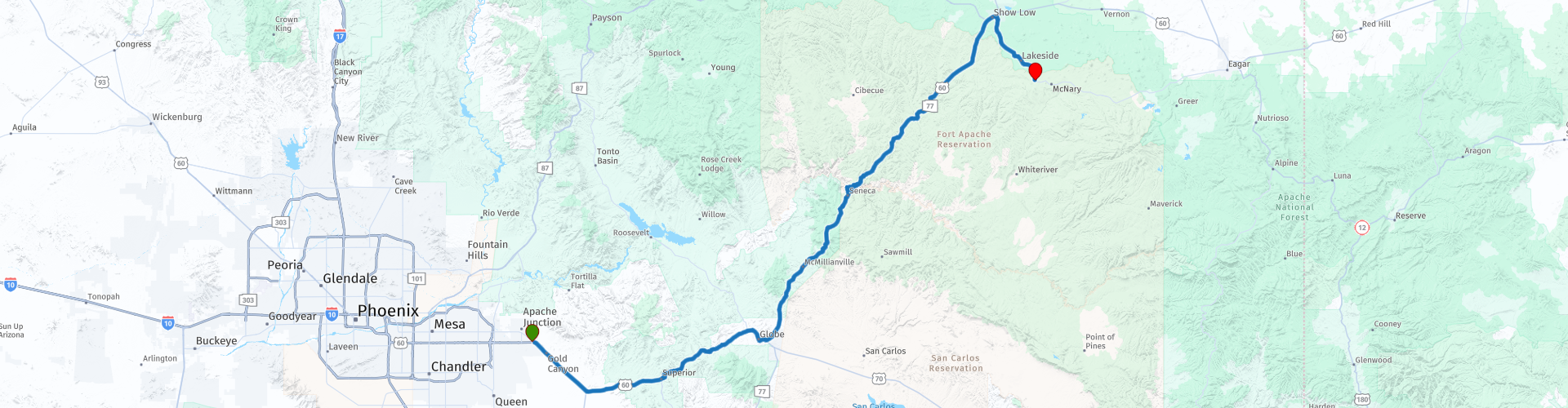
 This corridor represents one of the most geographically diverse and historically rich drives in the state, defined by massive engineering achievements and deep mining heritage.
Continuing on HWY 60 thru the beautiful Salt River Canyon with a night's stay in Show Low, Pine Top
I gave this route a five-star rating because it not only includes some of the most gorgeous scenery you will find, but also, the chance to immerse yourself into some of the extraordinary history of Arizona and the areas visiting.
 Share this route


Animation

Verdict


Duration
6h 35m

Mode of travel
Car or motorcycle

Distance
250.02 km

Countries

 RouteXpert Review
 The route successfully balances necessary logistical planning—beginning with a designated fuel stop in Apache Junction (Waypoint 1) and strategically scheduling an early refueling stop at the Circle K in Globe (Waypoint 10) due to the known "limited services until you get close to Show Low" —with a high-density focus on historical and scenic experiences.
The central feature of the journey is the challenging and spectacular traverse of the Salt River Canyon. This drive, which navigates a massive gorge often compared to a less-crowded Grand Canyon , provides a unique opportunity to descend to the river floor and ascend the opposing cliff face, confirming its status as a "spectacular surprise". The final destination is Show Low and the Pinetop-Lakeside area, culminating in an overnight stay on White Mountain Apache tribal land at the Hon Dah Casino Resort (Waypoint 36).
An analysis of the chosen Points of Interest (POIs) suggests a deliberate preference for experiences rooted in authenticity and historical continuity. Stops are planned at a local "Mom & Pop Mexican place" (Los Jilbertos, Waypoint 6) and Charlie Clark's Steakhouse (POI 33), an establishment recognized for being the oldest continuously operating restaurant in the White Mountains. This prioritization of deep local history, ranging from mining ghost towns (McMillenville, Waypoint 11) to Prohibition-era dining (Charlie Clark's), elevates the itinerary from a simple transit route to a curated historical and environmental tour.
The Western Approach: Logistics and Engineering Legacy (Apache Junction to Globe)
Initial Staging and Logistical Anchors (WPs 1-8)
The itinerary commences at a Chevron gas station in Apache Junction (Waypoint 1). This initial waypoint serves as the logistical anchor, ensuring the vehicle is fueled and prepared for the transit through the increasingly isolated terrain eastward. The subsequent path quickly engages the mountainous topography east of Superior, Arizona.
A critical infrastructural point is encountered near Superior at Waypoint 3, marked by a specific warning regarding entry into the Queen Creek Tunnel. This modern tunnel and the associated alignment were monumental achievements, designed to bypass the exceedingly steep and challenging original routing. Immediately upon exiting this tunnel section, the route calls for an essential stop at an overlook (Waypoint 4), noting explicitly that the "Landscape will completely change". This sharp geographical transition moves the traveler from the Superstition Mountain environment into the distinct geological and industrial terrain of the Globe-Miami mining district.
The route incorporates a designated sustained stop for travelers at Los Jilbertos in Miami (Waypoint 6), chosen for its reputation as a "Mom & Pop Mexican place" offering "Good food". This early stop serves a vital function, providing the primary sustained rest and dining opportunity before the journey transitions into the remote service-limited corridor leading to the Salt River Canyon.
The Legacy of the Million Dollar Highway
The necessity for the modern infrastructural features near Superior speaks directly to the ambitious and ultimately insufficient road-building efforts of the early 20th century. The modern Queen Creek Tunnel (completed in 1952), utilized by the traveler (Waypoint 3), replaced what was known locally as the Superior-Miami Highway, or the "Million Dollar Highway." Constructed between 1922 and 1926, this original alignment was Arizona’s most ambitious highway project of its time, but its narrow, steep, and curvy nature quickly became inadequate for modern traffic.
The existence of the modern tunnel is thus a direct consequence of the limitations of the original engineering. The previous route included the historic Claypool Tunnel (blasted in 1926) and was abandoned after the new Queen Creek Bridge (1949) and Tunnel (1952) were completed. This abandoned stretch, now part of the Legends of Superior Trails (LOST), offers a walking comparison for those interested in the route’s history. The warning issued at Waypoint 3, concerning the entry into the modern tunnel, subtly reinforces the immense scale of difficulty inherent in forging a functional highway through this dramatic topography.
The itinerary’s strategic logistical planning becomes overtly clear with the mandated stop at the Circle K in Globe (Waypoint 10). The traveler notes that refueling here is critical, recognizing the looming service scarcity. The distance from Apache Junction to Show Low is over 100 miles, and by ensuring the tank is full in Globe, the driver is prepared for the substantial remote driving required through the Salt River Canyon and White Mountain Apache Tribal land, where commercial services are sparse or nonexistent until the destination is reached.
Historic Gila County: Copper, Silver, and Cultural Crossroads (Globe and Miami)
The itinerary’s passage through Globe and Miami is expertly structured to capture the region’s volatile yet enduring mining history, a story defined by a swift shift from silver speculation to massive copper production.
The Mining History Spine
The earliest booms in the area centered on silver, notably the discovery that led to the formation of McMillenville, a short-lived town northeast of Globe. Waypoint 11 marks the location of the McMillenville Historic Marker, commemorating the discovery of native silver at the "fabulous Stonewall Jackson Ledge" in 1874. Despite the initial boom, the area quickly busted; the post office closed by 1882, and the town was largely abandoned by 1886.
The region’s true economic foundation, however, shifted to copper. Early prospectors initially viewed copper minerals as less valuable, but the burgeoning national demand for electricity, telegraphs, and telephones in the late 19th century rapidly changed that perspective. The Old Dominion mine, for instance, operated for 50 years, yielding 800 million pounds of copper and serving as the economic bedrock of Globe until its closure in 1930. This massive industrial output contrasts starkly with the ephemeral silver rush memorialized at McMillenville. POI 32, the Emsco Mine, located near the Salt River Mining District, adds further nuance, representing smaller, specialized industrial operations, in this case focusing on asbestos mining, which began in 1921. The inclusion of these sites maps the breadth of Gila County’s extractive past.
Curating the Historical Immersion
The traveler has selected POIs that ensure a comprehensive historical exploration, linking the ghost town relics to institutional preservation.
POI 5, the Bullion Plaza Cultural Center and Museum, focuses specifically on the "mining heritage" of the Globe/Miami area. Its exhibits, financially supported by modern mining firms such as FreeportMcMoRan and Resolution Copper, highlight the continuous economic importance of mineral extraction in the region.
Complementing this is POI 8, the Gila County Historical Museum, situated in the historic 1920 Mine Rescue Station. The museum provides an immersive experience, featuring artifacts related to mining, ranching, and Native American culture, including historic mine rescue equipment. By selecting both the Bullion Plaza and the Gila County Museum, the traveler engages with the full spectrum of industrial history, from the high-stakes financial operations to the practical, safety-focused culture that developed around the major copper mines. The physical location in the Mine Rescue Station itself symbolizes the community’s long-term investment, contrasting sharply with the boom-and-bust cycle of the silver camps like McMillenville.
The route’s reliance on US-60, a corridor vital to Arizona’s economy since the 1920s, necessitates constant vigilance regarding road conditions. The Arizona Department of Transportation (ADOT) frequently undertakes major maintenance projects in this rugged region, including ongoing pavement rehabilitation north of Globe and bridge replacement projects near Superior, which have required extended closures and lane restrictions. This constant need for heavy maintenance on the highway system confirms that, while modern engineering has vastly improved the journey, the rugged landscape continues to pose significant challenges to infrastructure integrity.
The Climax: Traverse of the Salt River Canyon Scenic Byway
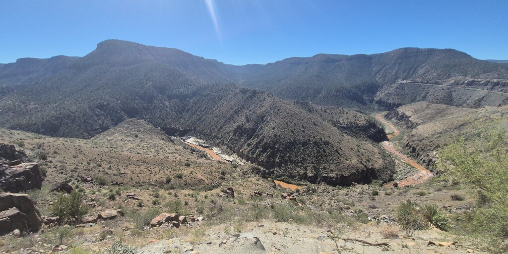
The drive through the Salt River Canyon is the geographical and scenic highlight of the itinerary, offering a unique vehicular experience through a massive gorge. This segment begins shortly after Globe and proceeds for approximately 83.5 miles toward Show Low.
Geographical and Cultural Context
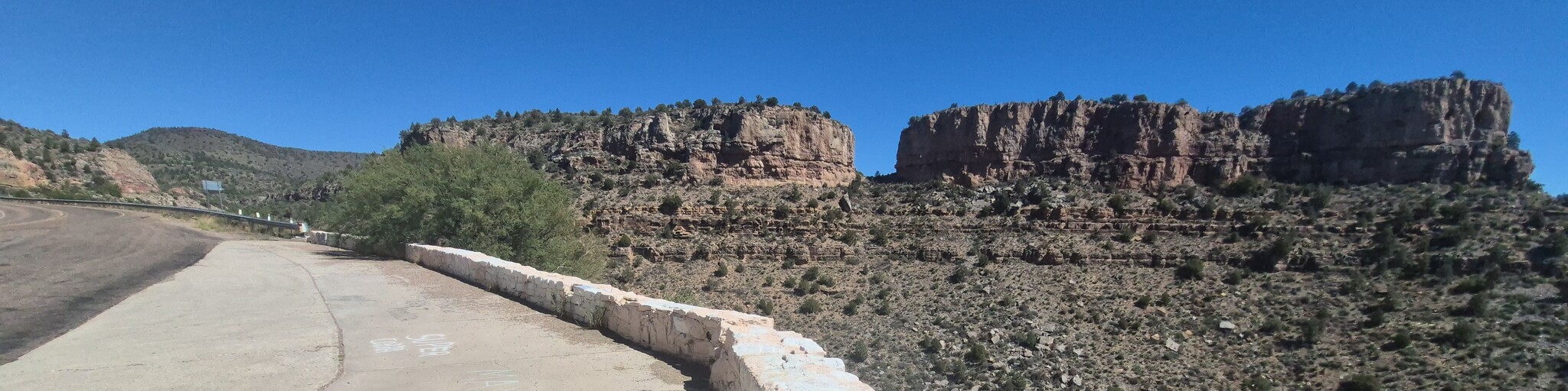
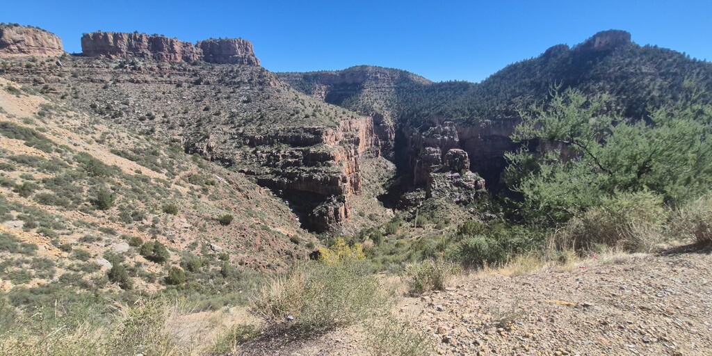
The canyon is renowned for its spectacular scenery, providing views of the Salt River surrounded by massive cliffs. Unlike the Grand Canyon, US-60 descends to the canyon floor, crosses the river, and then climbs the far side, offering a highly immersive perspective. The road itself is carved into the cliffs, featuring sharp turns and curvy pathways, though it eventually flattens out onto a high plateau.
Culturally, this entire scenic drive traverses lands belonging to the San Carlos Apache and White Mountain Apache Tribes. This tribal jurisdiction requires specific permits for recreational activities on the river, such as kayaking or rafting, particularly during the high flow season between March 1st and May 15th. While the drive itself does not require special vehicle permits in good weather, respect for tribal governance and land management is essential.
The Overlook Sequence and Rest Stops
The traveler’s itinerary includes a dense sequence of dedicated stops (WPs 14-26), demonstrating an intent to capture the full visual splendor of the canyon. These locations, including the Lower Northside Overlook (WP 20) and the Salt River Canyon Viewpoint North (WP 21), are precisely placed to maximize vistas of the geological formations.
Of particular logistical importance is Waypoint 17, the Salt River Canyon Rest Stop. This rest area, situated on the border of the tribal lands, is a crucial break point in a remote area and features composting restrooms. Crucially, the site also includes stairs leading directly down to the Salt River, allowing travelers to step off the highway and gain stunning, close-up views of the river and the canyon bridges. This feature elevates the stop beyond mere necessity, transforming it into a moment of genuine experiential engagement with the environment.
The Curiosities of the Canyon Roadside
The itinerary includes two highly specific and unique historical relics: an "old, abandoned gas station" (Waypoint 18) and an "old, abandoned Salt River Canyon Jail Cell" (Waypoint 19). These roadside remnants—the jail cell being a documented, if informal, attraction —anchor the narrative of the corridor’s isolation and rugged early history.
The inclusion of these raw, decaying pieces of infrastructure creates a compelling contrast when compared to the well-maintained, modern facilities of the Rest Stop (WP 17). The abandoned jail cell likely served early construction crews or territorial law enforcement, illustrating the isolated and rudimentary governance required when first constructing this essential, remote highway link. This thematic pairing—modern convenience versus untamed history—enriches the overall experience by highlighting the immense efforts required to civilize this mountainous terrain.
The Northern Ascent and Geographic Transition
The scenic pull-offs continue as the route ascends the canyon’s north side, culminating at Waypoint 26, the Becker Butte Lookout. This viewpoint serves as the final elevated panorama of the high canyon walls before the road departs the immediate canyon system.
After crossing the Salt River Canyon Bridge and passing this final lookout, the ecological environment begins to shift dramatically. The terrain transitions away from arid desert canyon species into zones dominated first by piñon and juniper, and eventually, around the crossing of Carrizo Creek (approximately Mile 60 from Globe), into the high-elevation landscape of ponderosa pines and oaks characteristic of the White Mountains. This profound and swift ecological change is one of the most memorable features of the US-60 scenic drive.
Transition to the White Mountains and Show Low Arrival
The final portion of the route involves the last ascent onto the plateau where the White Mountains begin to dominate the horizon. After the final scenic pull-off (Waypoint 27), the highway passes through tribal lands before reaching the destination city of Show Low, approximately 80 miles northeast of Globe.
Show Low possesses a historical origin story that contrasts sharply with the gritty, industrial heritage of the Globe-Miami district. The city's name is derived from a famous, legendary card game of "seven up" played between early ranch partners Marion Clark and Corydon Cooley. Unable to agree on who should leave the shared 100,000-acre ranch, the men settled the dispute via cards. Clark challenged Cooley, "Show low and you take the ranch." Cooley drew the deuce of clubs—an act commemorated by the naming of the town’s main street, Deuce of Clubs (WPs 28, 29).
POI 29, the Show Low Historical Museum, is essential for exploring this local pioneer history and the unique circumstances of the town’s founding. However, the traveler must heed a crucial logistical caveat: the museum operates seasonally, generally opening from March through November, with limited hours (Wednesday through Saturday, 10:00 am to 3:00 pm). Travel outside of this window would require substituting this cultural stop.
The nearby Williams Creek National Fish Hatchery (POI 34) is noted as a regional point of interest, reflecting the importance of water resources, conservation, and recreational fishing within the White Mountain area, shifting the thematic focus from industrial extraction to environmental management.
Destination Analysis: Hon Dah and Pinetop-Lakeside Hospitality
The journey concludes in the Pinetop-Lakeside region, a popular high-elevation escape that offers a distinct climate and array of amenities.
Lodging and Amenities (Waypoint 36)
The designated overnight lodging is the Hon Dah Casino Resort and Hotel (Waypoint 36), located near the intersection with AZ-73. This major resort complex is situated on the White Mountain Apache Reservation and functions as a significant economic and entertainment hub for the region.
The resort offers comprehensive year-round amenities. It is strategically linked to other tribal assets, most notably the nearby Sunrise Ski Resort, which facilitates not only winter sports but also summer activities, including scenic chairlift rides, mountain biking, and popular fishing competitions at Sunrise Lake. For travelers utilizing recreational vehicles, the Hon-Dah RV Park, located across the street, provides extensive facilities, including over 500 sites with full hookups and 24-hour security. The selection of this destination recognizes the economic sovereignty and robust tourism infrastructure developed by the White Mountain Apache Tribe in leveraging the desirable high-elevation climate.
Destination Dining: History and Cuisine
The dining choices maintain the itinerary’s high standard for historical depth and local authenticity. The traveler has prioritized two highly regarded steakhouses, including an option right on the main highway.
POI 33, Charlie Clark's Steakhouse, is a premier dining destination recognized as the oldest continuously operating restaurant in the White Mountains, with a history stretching back 85 years. It is also reportedly the fifth oldest steakhouse in Arizona overall. The history of the site is particularly colorful; during Prohibition, it operated as a speakeasy where "white lightening" was served. When Charlie Clark acquired the property in 1938, patrons were initially required to prepare their own drinks while he cooked, reflecting the rustic, pioneering hospitality of the time. Today, the Western-themed ambiance, complete with rustic decor and taxidermy, provides an atmosphere that perfectly complements the historical journey taken through Gila County.
POI 31, Cattleman's Steakhouse and Lounge, offers a strong secondary dining option. Furthermore, the Hon Dah Casino Resort itself provides convenient, high-quality alternatives within the hotel complex. The strategic choice of Charlie Clark's ensures that the experiential theme of engaging with authentic Arizona history extends seamlessly into the evening meal.
Strategic Recommendations and Itinerary Optimization
The rigorous review of this route confirms its high potential for scenic and historical fulfillment but also necessitates adherence to specific logistical and temporal requirements.
Temporal Planning and Safety Advisories
The Salt River Canyon traverse is the most time-intensive segment due to the frequency of planned stops (WPs 14-26). To fully appreciate the canyon views, the abandoned roadside relics (WPs 18, 19), and the rest area access to the river (WP 17), an allowance of 3 to 4 hours for the 83.5-mile segment between Globe and Show Low is prudent. This segment should be driven during optimal daylight hours to maximize safety on the winding roads and capitalize on photographic opportunities.
Furthermore, travelers must prioritize checking current Arizona Department of Transportation (ADOT) advisories immediately prior to departure. The US-60 corridor, particularly near Superior, is frequently subject to scheduled closures for major construction projects, such as the Queen Creek Bridge replacement. These construction efforts, while temporary, can introduce significant multi-hour delays if not planned for.
Finally, the route involves a substantial elevation gain. Travelers ascend from the desert floor near Apache Junction to the high-elevation forests, with the destination near Hon Dah situated around 7,000 feet above sea level. Drivers should be mindful of potential temperature variances and the possibility of encountering different weather conditions, particularly snow or ice during shoulder seasons.
Experiential Curating and Photo Opportunities
To maximize the thematic depth of the itinerary, the traveler should consciously integrate the historical layers encountered along the path. The experience shifts from witnessing high-stakes mining fortunes and immense infrastructure spending (Globe-Miami) to encountering historical happenstance (the "Deuce of Clubs" origin of Show Low).
A critical stop for immersion is the Salt River Canyon Rest Stop (WP 17). Travelers should utilize the stairs provided at this location to descend to the river level. This provides unique access for photography and sensory appreciation of the canyon floor, a perspective missed by those who only stop at the rim overlooks. Similarly, locating and interpreting the abandoned jail cell (WP 19) offers a valuable, tangible connection to the rugged conditions of the road’s construction era.
Final Logistical Confirmation
The strategic decision to refuel early at the Circle K in Globe (Waypoint 9) must be executed without fail, given the explicitly noted lack of services on US-60 until the White Mountains are reached.
If the itinerary includes plans for water recreation on the Salt River, securing the necessary permits from the San Carlos Apache Tribe and the Tonto National Forest well in advance is mandatory, especially if traveling during the spring high season. The route successfully integrates deep-seated local history and natural spectacle, provided these logistical and cultural requirements are met.
Consolidated Logistical Waypoints and Critical Warnings
This text summarizes the most critical logistical waypoints and associated warnings, consolidating the key planning requirements for the traveler.
 Links
Links
Take a Scenic Drive to an Arizona Overlook That's Like a Miniature Grand Canyon
Local History of Globe and Miami in Gila County, Arizona AZ
Show Low Historical Society Museum | AMERICAN HERITAGE
Hon-Dah Resort Casino
Once A Speakeasy, Charlie Clark's Is The Oldest Steakhouse In Arizona's White Mountains
Local History of Globe and Miami in Gila County, Arizona AZ
Show Low Historical Society Museum | AMERICAN HERITAGE
Hon-Dah Resort Casino
Once A Speakeasy, Charlie Clark's Is The Oldest Steakhouse In Arizona's White Mountains
 Usage
Usage Want to download this route?
You can download the route for free without MyRoute-app account. To do so, open the route and click 'save as'. Want to edit this route?
No problem, start by opening the route. Follow the tutorial and create your personal MyRoute-app account. After registration, your trial starts automatically.  Disclaimer
Use of this GPS route is at your own expense and risk. The route has been carefully composed and checked by a MyRoute-app accredited RouteXpert for use on TomTom, Garmin and MyRoute-app Navigation.
Changes may nevertheless have occurred due to changed circumstances, road diversions or seasonal closures. We therefore recommend checking each route before use.
Preferably use the route track in your navigation system. More information about the use of MyRoute-app can be found on the website under 'Community' or 'Academy'.
.jpg/800px-Grand_Canyon_Horseshoe_Bend_(crop_2).jpg)
Arizona
About this region
Arizona (AIR-iz-OH-nə; Navajo: Hoozdo Hahoodzo Navajo pronunciation: [hoː˥z̥to˩ ha˩hoː˩tso˩]; O'odham: Alĭ ṣonak) is a state in the Western United States, grouped in the Southwestern and occasionally Mountain subregions. It is the 6th largest and the 14th most populous of the 50 states. Its capital and largest city is Phoenix. Arizona shares the Four Corners region with Utah to the north, Colorado to the northeast, and New Mexico to the east; its other neighboring states are Nevada and California to the west and the Mexican states of Sonora and Baja California to the south and southwest.
Arizona is the 48th state and last of the contiguous states to be admitted to the Union, achieving statehood on February 14, 1912. Historically part of the territory of Alta California in New Spain, it became part of independent Mexico in 1821. After being defeated in the Mexican–American War, Mexico ceded much of this territory to the United States in 1848. The southernmost portion of the state was acquired in 1853 through the Gadsden Purchase.
Southern Arizona is known for its desert climate, with very hot summers and mild winters. Northern Arizona features forests of pine, Douglas fir, and spruce trees; the Colorado Plateau; mountain ranges (such as the San Francisco Mountains); as well as large, deep canyons, with much more moderate summer temperatures and significant winter snowfalls. There are ski resorts in the areas of Flagstaff, Alpine, and Tucson. In addition to the internationally known Grand Canyon National Park, which is one of the world's seven natural wonders, there are several national forests, national parks, and national monuments.
Since the 1950s, Arizona's population and economy have grown dramatically because of migration into the state, and now the state is a major hub of the Sun Belt. Cities such as Phoenix and Tucson have developed large, sprawling suburban areas. Many large companies, such as PetSmart and Circle K, have headquarters in the state, and Arizona is home to major universities, including the University of Arizona and Arizona State University. Traditionally, the state is politically known for national conservative figures such as Barry Goldwater and John McCain, though it voted Democratic in the 1996 presidential race and in the 2020 presidential and senatorial elections.
Arizona is home to a diverse population. About one-quarter of the state is made up of Indian reservations that serve as the home of 27 federally recognized Native American tribes, including the Navajo Nation, the largest in the state and the United States, with more than 300,000 citizens. Since the 1980s, the proportion of Hispanics in the state's population has grown significantly owing to migration from Mexico. In terms of religion, a substantial portion of the population are followers of the Catholic Church and The Church of Jesus Christ of Latter-day Saints (Mormon).
Read more on Wikipedia
Arizona is the 48th state and last of the contiguous states to be admitted to the Union, achieving statehood on February 14, 1912. Historically part of the territory of Alta California in New Spain, it became part of independent Mexico in 1821. After being defeated in the Mexican–American War, Mexico ceded much of this territory to the United States in 1848. The southernmost portion of the state was acquired in 1853 through the Gadsden Purchase.
Southern Arizona is known for its desert climate, with very hot summers and mild winters. Northern Arizona features forests of pine, Douglas fir, and spruce trees; the Colorado Plateau; mountain ranges (such as the San Francisco Mountains); as well as large, deep canyons, with much more moderate summer temperatures and significant winter snowfalls. There are ski resorts in the areas of Flagstaff, Alpine, and Tucson. In addition to the internationally known Grand Canyon National Park, which is one of the world's seven natural wonders, there are several national forests, national parks, and national monuments.
Since the 1950s, Arizona's population and economy have grown dramatically because of migration into the state, and now the state is a major hub of the Sun Belt. Cities such as Phoenix and Tucson have developed large, sprawling suburban areas. Many large companies, such as PetSmart and Circle K, have headquarters in the state, and Arizona is home to major universities, including the University of Arizona and Arizona State University. Traditionally, the state is politically known for national conservative figures such as Barry Goldwater and John McCain, though it voted Democratic in the 1996 presidential race and in the 2020 presidential and senatorial elections.
Arizona is home to a diverse population. About one-quarter of the state is made up of Indian reservations that serve as the home of 27 federally recognized Native American tribes, including the Navajo Nation, the largest in the state and the United States, with more than 300,000 citizens. Since the 1980s, the proportion of Hispanics in the state's population has grown significantly owing to migration from Mexico. In terms of religion, a substantial portion of the population are followers of the Catholic Church and The Church of Jesus Christ of Latter-day Saints (Mormon).
View region
 Statistics
  26
26Amount of RX reviews (Arizona)
 30545
30545Amount of visitors (Arizona)
 556
556Amount of downloads (Arizona)
 Route Collections in this region
 Car or motorcycle tour through the western US
This collection contains all 15 routes driven by MRA Goldmember André ter Schegget during his three-week tour through the west of America.
The places to visit, the attractions and beautiful photo spots are nicely marked on the routes. The routes have been fully checked and made equal for the Garmin and the TomTom. Enjoy this wonderful trip and let us know how it was! Enjoy and stay safe!
Order of the tour:
Route 01: from Los Angeles and via Pacific Coast Highway to Solvang
Route 02: Solvang to Monterey / Pacific Grove
Route 03A: Monterey to San Francisco
Route 03B: if you are by car instead of the motorcycle, as motorcycles are not allowed on the 17 Mile Drive: from Monterey to the 17 Mile Drive and further to San Francisco
Route 04: from San Francisco via Nappa and Eldorado National Forrest to Topaz Lake
Route 05: from Topaz Lake via Bodie and Yosemite to Oakhurst
Route 06: from Oakhurst via Kings Canyon NP and Sequoia NP and Giant Forest to Exeter
Route 07: Exeter via Isabella Lake and Ridgecrest to Death Valley
Route 08: from Death Valley via Valley Of Fire to Mesquite
Route 09: from Mesquite via Zion NP and Dixie NF to Hatch
Route 10: Hatch via Bryce Canyon to Page
Route 11: from Page via Grand Canyon to Williams
Route 12: from Williams via Seligman and Route 66 to Kingman and via Hoover Dam to Las Vegas
Route 13: from Las Vegas via Oatman and Lake Havasu to Parker
Route 14: from Parker via Joshua Tree to Rancho Mirage
Route 15: Rancho Mirage via Palm Springs to Santa Monica
View Route Collection
Top car and motorcycle tour through the west of the USA
By car or motorcycle through the West of America is a journey that you do not just make, so also not driving 15 days and then back home. No, book a stay of several days in Los Angeles, Las Vegas, San Francisco and again Los Angeles to also visit several places of interest in these cities, so that this tour becomes an unforgettable tour that you can remember with pleasure.
Do not forget to arrange and pack the following items:
*This is only a summary and completely personal and may differ per person.
Take out travel insurance, +31 for numbers in GSM, (partially) take out gas, Health insurance coverage at destination?, Switch off electrical appliances, Lighting (time clock), Check passport validity, Antenna from radio/TV due to lightning, Residence address for those left behind, Remote control house alarm, Book Smart Parking.
Hand luggage:
Liquids in packaging of max. 100 ml, Liquids in hand luggage in transparent plastic bag.
For on the road:
Candy, Book, Earplugs, Country and road map(s), Directions, Maps in your navigation system
Money & Securities:
Bank card / giro card, Credit card (think pin code), Cash, Calculator for Internet banking, Medical insurance card, Travel insurance card.
Travel documents:
Passport, (International) Driver's License, Ticket(s), Reservation Tickets, Hotel Vouchers, Arrival/Departure Time, Check-in & Check-out Times, Valid Visa (ESTA), Travel Guide.
Clothing:
Underwear, Belt, Shirts/ T-shirts, Shorts, Long pants, Shoes, Socks, Swim trunks, Towel, Slippers.
Personal stuff:
Watch, House Keys, Wallet, Sunglasses.
Toiletries:
Deodorant, Shower gel / Soap, Comb / brush, Shaving equipment, Shampoo, Toothbrush, Toothpaste, Sanitary pads
Health & Medicine:
Own medicines, Insect repellent, Cold sore ointment, Ointment for insect bites, Sunscreen, Norit, Paracetamol, Suction cup for insect bites, First aid bag.
Miscellaneous:
Travel bag / waist bag, Leatherman (= checked luggage), Pen or pencil, Headlamp, Lighter, Tools & Electronics, Mobile phone & charger, Photo/video camera & charger, Memory card(s), World plug / adapter, Ipod & charger, Adapter cable Ipod, Headphones, iPad & charger, Navigation & charger/plug, Plug socket, Fuelpack battery.
Engine (accessories):
Helmet, Motorcycle clothing, Motorcycle boots, Chain lock / disc brake lock, Gloves, Bandana, Inner bags (plastic shopping bag), Insulation bag, Tension straps, Tie wraps, Rain suit, Rainaway.
Addresses:
Address list, Embassy telephone number, Telephone number to block (bank) card(s), Telephone number (airline tickets).
View Route Collection