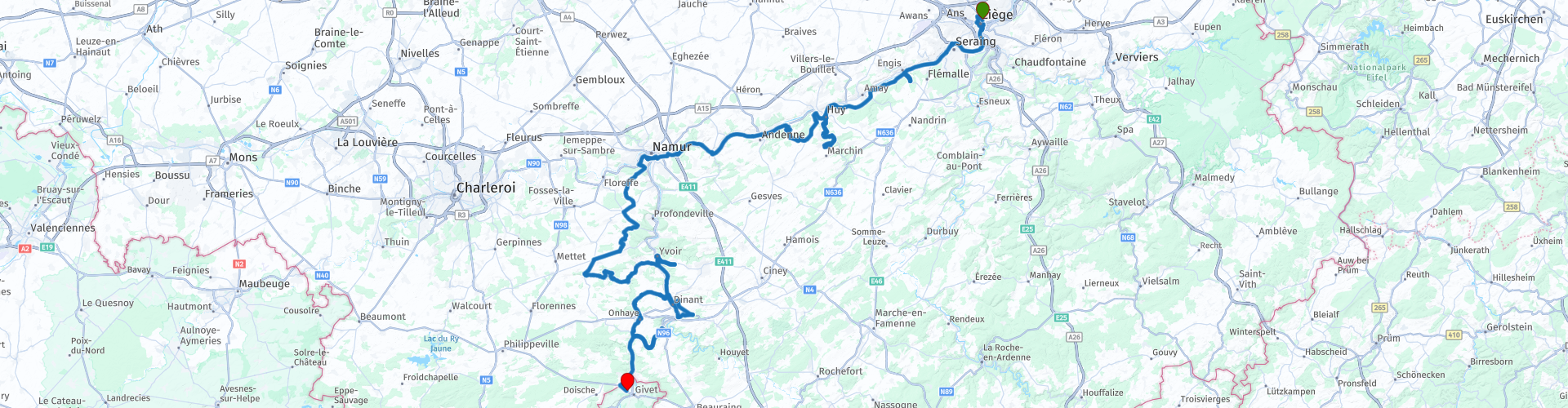
Luik Givet de Citadellen langs de Maas

This route was brought to you by:
RouteXpert Stijn Claus
Last edit: 28-06-2021
 Route Summary
 We have lunch at the Abbey of Maredsous.
The roads are mainly secondary roads.
Most of the sights are off the main road, but these are clearly marked from the main road. Please note that the road surfaces of the access roads are not always in good condition.
 Share this route


Animation

Verdict


Duration
4h 29m

Mode of travel
Car or motorcycle

Distance
211.38 km

Countries


 RouteXpert Review
 Today there are still many remains of the citadel visible. From here you get a beautiful panoramic view of the city center of Liège.
Then we follow the banks of the Maas to Huy. Here we find the Huy citadel. This was once one of the most beautiful castles of our region, but due to its strategic location, the castle must make way for a sober but impregnable fortress. In 1940, the Germans turned it into one of the most lurid prisons in Belgium: for more than 7 years more than 7,000 people were locked up in the dungeons as the last leg before they boarded the train from death to concentration camp.
The route takes us to Namur, where the Counts of Namur built their residence. Between the 15th and 18th centuries the fortress was repeatedly besieged, so that it always passed into different hands. Skilful military architects and engineers are trying in vain to turn it into an impregnable stronghold, making the citadel of Namur in the 18th century one of the largest in Europe, with 80 hectares of defenses. It was Napoleon who gave her the name "termite mound of Europe" because of the miles of underground passages.
From Namur the route goes further south, we no longer follow the banks of the Maas and drive through the woods to the abbey of Maredsous. In addition to a guesthouse and a reception building with shops, museum space, this Benedictine monastery houses a restaurant.
After lunch at the abbey we drive back to the Maas valley. This brings us to the medieval ruins of the castle and the fortified village of Poilvache. From the rocky hill on which the fortress is located, one has a good view over the valley of the Maas.
A dozen kilometers further on the route arrives in Dinant. Here we meet two reinforced locations.
The first fortifications on the rocks above Dinant date back to the 11th century. They have to protect the border town of the prince-diocese of Liège on one of the few bridges over the Meuse against the counts of Namur, with the castle of Crèvecoeur on the other side.
From Dinant we drive to France, on the way we pass by the castle of Freÿr It is called a greatly reduced Versailles. It was originally an Renaissance castle, expanded in the 18th century and was once the residence for dukes and their royal guests.
The route ends at the Citadel of Givet. This fort was built in 1555 by order of Emperor Charles V. He needed a strategic position in the heart of Europe and the location of Givet was perfect in his eyes.
Part of the Citadel of Givet is the Fort Charlemont. You can visit this historic monument. The fort has, among other things, an 800-meter long tunnel system, 3 kilometers of trenches and an abandoned village with 48 buildings.
This route gets 4 stars because of the beautiful view of the route and the many nice sights.


 Links
Links  Usage
Usage Want to download this route?
You can download the route for free without MyRoute-app account. To do so, open the route and click 'save as'. Want to edit this route?
No problem, start by opening the route. Follow the tutorial and create your personal MyRoute-app account. After registration, your trial starts automatically.  Disclaimer
Use of this GPS route is at your own expense and risk. The route has been carefully composed and checked by a MyRoute-app accredited RouteXpert for use on TomTom, Garmin and MyRoute-app Navigation.
Changes may nevertheless have occurred due to changed circumstances, road diversions or seasonal closures. We therefore recommend checking each route before use.
Preferably use the route track in your navigation system. More information about the use of MyRoute-app can be found on the website under 'Community' or 'Academy'.