Zeilberg Bollendorf

This route was brought to you by:
RouteXpert Hans van de Ven (Mr.MRA)
Last edit: 03-03-2019
 Route Summary
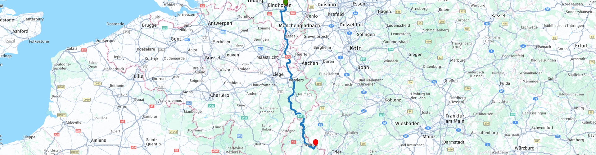
 Starting point: Café Zaal 't-Vertierke in Deurne (Zeilberg).
End point: Hotel Café Hauer in Bollendorf.
 Share this route


Animation

Verdict


Duration
6h 4m

Mode of travel
Car or motorcycle

Distance
298.33 km

Countries


 RouteXpert Review
 What we thought of the hotel at the time: https://www.mtczeilberg.nl/verslagen_details.phtml?id=3
After you have departed from Zeilberg, you drive inland to Klimmen, where the 1st (coffee) stop is planned at IJssalon Pleinzicht. In front of the ice cream parlor is a large parking lot where you can park the engine in sight.
After coffee we drive on and then stop at the American military cemetery Henri-Chapelle and Lac de la Gileppe to take some pictures.
---
The more than 20 hectares of the American military cemetery Henri-Chapelle are home to the remains of 7,992 American soldiers. Most of these men lost their lives during the advance of the American forces in Germany. The 1st American Infantry Division liberated this location on 11 September 1944. A provisional war cemetery was established on 28 September 1944.
Their tombstones are arranged in wide arches on an outstretched, sloping lawn. A road cuts through the cemetery. To the west of it, a viewpoint offers a beautiful view of the peaceful Belgian countryside that once was a battlefield. To the east there is a colonnade which forms the memorial together with the chapel and the visitors room. The chapel is simple, but richly decorated. The visitors' room contains two maps that give an insight into the military operations of the American army, engraved in black granite, with inscriptions referring to the victories of the American forces. On the rectangular pillars of the colonnade the names of 450 missing soldiers are engraved. Behind the names of the missing persons who have been found and identified, a rosette has been applied.
The cemetery contains the American dead of two major military campaigns: the campaign of the 1st American Army through Northern France, Belgium, the Netherlands and Luxembourg towards Germany (September 1944) and the Battle of the Bulge, the German counter-offensive in the Ardennes (December 1944 - January 1945).
From the temporary cemetery Henri-Chapelle the first repatriation of fallen American soldiers to the United States was organized for reburialization in their own country. The repatriation program began on 27 July 1947 with a special ceremony in Henri-Chapelle. The first ship with mortal remains left Antwerp in early October after an impressive ceremony attended by 30,000 Belgian citizens.
---
The Gileppestuwdam (French: barrage de la Gileppe) is a dam in the Belgian province of Liège. The supply of water is ensured by the Gileppe, which rises in the High Fens. The original wall was the oldest concrete dam wall in Europe. The complex was officially opened on 28 July 1878 by King Leopold II. The water absorption capacity of the reservoir was then 13 million m³, with an area of 86 ha. The original purpose of the dam was to provide usable water for the textile industry in the Verviers area.
In the period 1968-1971 the dam was raised by more than 10 m. Since then the capacity of the lake is 26.5 million m³ at an area of 130 ha. Together with the Vesder dam in Eupen, the lake now provides drinking water.
The most important feature of the dam is a 13.5 meter high and 300 ton lion from sandstone. The lion stands on top of the dam wall and was put down so that he looks proudly in the direction of the only 5 kilometers removed border with the then Prussia.
---
After taking the pictures it is time to have lunch, we do this at the Waterfalls of Coo, where you can park your motorcycle in sight. There is plenty of choice, so something for everyone.
After lunch we often swing on beautiful motorways towards Ouren where we stop at Hotel Rittersprong for coffee with some goodies. Again, the engines are beautiful in sight. We stop in Hosingen at Dosberbreck Sam's Lounge once more to stretch the legs and refuel. After the coffee again, the bridge (route point 61) is completely lost in July (we are so lucky) due to heavy rainfall. Just before the day we arrive at the end of this route, we first refuel when we are still in Luxembourg at the Q8, then we cross the Sauer and take a right. If you look at photo 3, you can see that the water in the Sauer is already very high.
We are at Hotel Hauer, where we stay for the Spring weekend.
See the video to get an impression of the surroundings, the images are occasionally unclear, but that is because of the rain that we have had along the way: https://www.youtube.com/watch?v=fWsDKEeDmzQ


 Usage
Usage Want to download this route?
You can download the route for free without MyRoute-app account. To do so, open the route and click 'save as'. Want to edit this route?
No problem, start by opening the route. Follow the tutorial and create your personal MyRoute-app account. After registration, your trial starts automatically.  Disclaimer
Use of this GPS route is at your own expense and risk. The route has been carefully composed and checked by a MyRoute-app accredited RouteXpert for use on TomTom, Garmin and MyRoute-app Navigation.
Changes may nevertheless have occurred due to changed circumstances, road diversions or seasonal closures. We therefore recommend checking each route before use.
Preferably use the route track in your navigation system. More information about the use of MyRoute-app can be found on the website under 'Community' or 'Academy'.
;_vue_de_la_partie_occidentale_du_château-fort_(XIIIe–XIX_siècles).jpg/1280px-Bouillon_(Belgique);_vue_de_la_partie_occidentale_du_château-fort_(XIIIe–XIX_siècles).jpg)
Luxembourg
About this region
Luxembourg (French: Luxembourg [lyksɑ̃buʁ] (About this soundlisten); Dutch: Luxemburg [ˈlyksəmˌbʏrx] (About this soundlisten); German: Luxemburg [ˈlʊksəmbʊʁk] (About this soundlisten); Luxembourgish: Lëtzebuerg; Walloon: Lussimbork), also called Belgian Luxembourg, is the southernmost province of Wallonia and of Belgium. It borders on the country of Luxembourg to the east, the French departments of Ardennes, Meuse and Meurthe-et-Moselle to the south and southwest, and the Walloon provinces of Namur and Liège to the north. Its capital and largest city is Arlon (Luxembourgish: Arel, Dutch: Aarlen), in the south-east of the province.
It has an area of 4,459 km2 (1,722 sq mi), making it the largest Belgian province. With around 285,000 residents, it is also the least populated province, with a density of 64/km2 (170/sq mi), making it a relatively sparsely settled part of a very densely populated region.
It is significantly larger (70%), but much less populous than the neighbouring Grand Duchy of Luxembourg. About eighty percent of the province is part of the densely wooded Ardennes region. The southernmost region of the province is called Gaume or Belgian Lorraine (main city: Virton).
The Arelerland or Arlon region (in red on the map of arrondissements, below) bordering the neighbouring Grand-Duchy of Luxembourg has the particularity that many of its residents have historically spoken Luxembourgish, a language closely related to German, rather than the French or Walloon spoken elsewhere in the province.
The province was separated from the neighbouring Luxembourg by the Third Partition of Luxembourg, de jure in 1830–31 by the Conference of London dealing with the consequences of the Belgian Revolution of 1830, de facto in 1839, after William I, King of the Netherlands and Grand-Duke of Luxembourg, agreed to its decisions and thus the province was given to the newly created Kingdom of Belgium.
Read more on Wikipedia
It has an area of 4,459 km2 (1,722 sq mi), making it the largest Belgian province. With around 285,000 residents, it is also the least populated province, with a density of 64/km2 (170/sq mi), making it a relatively sparsely settled part of a very densely populated region.
It is significantly larger (70%), but much less populous than the neighbouring Grand Duchy of Luxembourg. About eighty percent of the province is part of the densely wooded Ardennes region. The southernmost region of the province is called Gaume or Belgian Lorraine (main city: Virton).
The Arelerland or Arlon region (in red on the map of arrondissements, below) bordering the neighbouring Grand-Duchy of Luxembourg has the particularity that many of its residents have historically spoken Luxembourgish, a language closely related to German, rather than the French or Walloon spoken elsewhere in the province.
The province was separated from the neighbouring Luxembourg by the Third Partition of Luxembourg, de jure in 1830–31 by the Conference of London dealing with the consequences of the Belgian Revolution of 1830, de facto in 1839, after William I, King of the Netherlands and Grand-Duke of Luxembourg, agreed to its decisions and thus the province was given to the newly created Kingdom of Belgium.
View region
 Statistics
  41
41Amount of RX reviews (Luxembourg )
 30239
30239Amount of visitors (Luxembourg )
 9740
9740Amount of downloads (Luxembourg )
 Route Collections in this region
 Route collection MRA NAVIGATION GRAND TOUR 2019
MRA NAVIGATION GRAND TOUR 2019 in short:
From 2019, MyRoute-app organizes every year the "MyRoute-app Navigation Grand Tour" exclusively for MyRoute-app Navigation users. During the Grand Tour you drive 4 routes during the calendar year. A few commands are included in each route. Participants who capture all 4 tracks via MyRoute-app Navigation have the chance to win a great prize. In 2019 we had chosen the 2nd World War as the theme for the 4 routes.
The routes and the assignments:
As mentioned, the theme of 2019 was the 2nd World War. A loaded theme, you are confronted with the dual nature of humanity; the willingness to kill for an ideology, we are better than them, cruelty, slaughter, but also heroism and sacrifices, would it ever change? I myself am very interested in world history, I have even studied it for a year at the university and certainly the 1st and 2nd world war have my interest. So it was no task to put together the routes, drive yourself and come up with the assignments.
Have fun driving these beautiful and interesting routes with a loaded theme!
View Route Collection
5 tours in Belgium in flat Flanders the hills of the Pays des Collines and the Ardennes
Those who like a winding and hilly course, along many small lanes with little to no traffic, will certainly find what they are looking for in the Pays des Collines, the region east and south of Ronse.
Between Diksmuide and Ypres there are many commemorative monuments of the First World War. In Vinkt in East Flanders, the monument commemorates the massacre that took place in May 1940.
Along rural quiet roads you can taste the history of World War I and II.
Marche-en-Famenne is an excellent starting point to thoroughly explore this plateau, which is cut by rivers and strewn with coniferous forests. The real Ardennes are the most hilly areas of Belgium behind the Meuse. Nature plays an all-important role on this trip.
In addition to the Ardennes, the route with start and end point in Huy also goes through a part of Condroz and Famenne. The Condroz, where wooded hills and valleys alternate, and the Famenne, which makes the transition to the Ardennes plateaus. In the summer it is wonderful motorcycling in the vast forests. You will not only enjoy the natural beauty, but you will also pass numerous castles, wild flowing Ardennes rivers, quiet villages and authentic tourist towns.
The tour from Namur runs through the Meuse area where you discover that the tributaries of the Meuse are of picturesque beauty. You will pass a large number of castles and fortresses. The roads along the Maas are busy arterial roads. But as soon as you can you will look for the smaller roads that are immediately a lot quieter and take us through forests and meadows.
View Route Collection