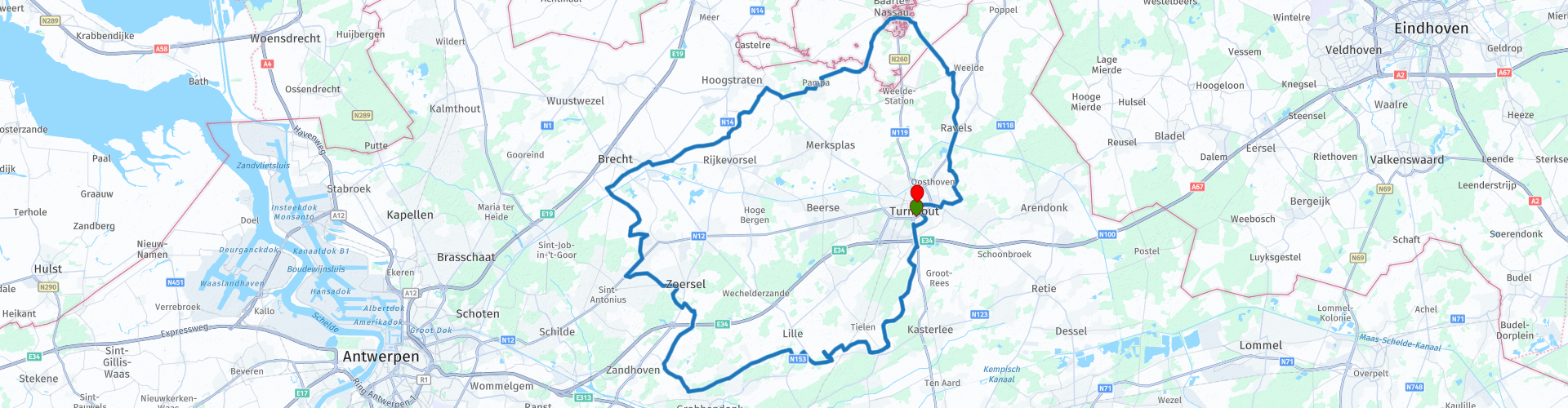
Rondrit Kempen vanuit Turnhout

This route was brought to you by:
RouteXpert Guy Heyns - Sr RouteXpert
Last edit: 10-12-2024
 Route Summary
 Whether you want to ride the shiny layer of your tires or you want to give your motorcycle (and yourself) the first movement after a winter break or want to prepare that one novice for the finer curves and some load changes, this tour is ideal.
Especially if you also want to fully enjoy the Kempen landscape.
The route departs and arrives in Turnhout, capital of the Kempen and affects almost all surrounding municipalities.
Fine country roads slide under the wheels as you 'warm up' yourself and your bike for more brisk work.
Pleasant, light tour, which still provides the necessary pleasure!
 Share this route


Animation

Verdict


Duration
3h 28m

Mode of travel
Car or motorcycle

Distance
110.98 km
 RouteXpert Review
 If you want to lose the glow of your tires, let your engine run warm again after a (winter) stop or want to let that one pupil feel what 'load change' means in practice, then this is a nice, relaxing curve trail along narrow Campine country roads the ideal course.
The fact that you also drive through a pleasant and educational landscape at the same time has also been taken into account, as has the fact that you are - for a little bit - sharing in some Kempian facts.
The route starts at the Carrefour Turnhout car park (rp1). There is a possibility to meet in a spacious safe parking lot, you can have breakfast / lunch / dinner, refuel and, if necessary, consult garage workshop and shop 'Auto 5' in case of technical problems.
You make a small drive through residential area, but from rp 3 the country road festival starts. Don't be put off by some emerging 'yellow' points in the route. Despite some things where attention is needed for a while, the chosen course remains a delight for your eyes and for your bands. Just after rp 4 you better watch out for two well hidden 'speed bumpjes'. They can knock the novice driver out of balance. Usually they are only recognizable by what the farmer's cart dropped just before or after, but otherwise they barely stand out. Just after rp 5, there is a brief danger zone with a bend with zero visibility. Watch out for oncoming traffic!
A little further on the road, about rp 6, you can regularly find fully packed soldiers. The area that is driven through is located near the military training center for paratroopers of the Belgian army. These paratroopers are known worldwide and they are all trained here. All forests in this area were once forbidden military terrain and heavy exercises took place here regularly.
From rp 7 you pass former military terrain which today is a recreation and nature education area. So expect many groups of children, hikers, and parking parents at the 'Hoge Rielen'.
After route point 8 you have left the busier zone and continue on to the first stop on the route, the café of the Trappist brewery Westmalle.
This café at route point 21 will spoil you with numerous dishes, large and small, and if necessary you can also taste the famous Trappist beer. However, neither the monastery nor the brewery itself can be visited. This is so as not to disturb the daily life of the brothers.
For those who would like additional information, you can watch a film about the brewery in the café or open the attached link for more information. Around the abbey there is also a short walking route with various stops where you will get an explanation about the life in the abbey and the craft activities. This walking route can be followed via a website (www.atww.be) or with the free brochure that is offered in Café Trappisten.
Fun fact is that the brothers of the abbey also brew Trappist beer under 'blue' stopper. This beer is only for the fathers themselves. Employees who are caught with a bottle under 'blue stopper' are irrevocably discharged with immediate effect.
Attention, it can be crowded here, especially on weekend days. After all, you get food and drinks here at reasonable prices ...
If it is too full (and that is quite possible ...), there is a next resting place ready along the Dessel-Turnhout Schoten canal (rp 25) in 'De Goeien Tijd'.
This channel that you cross on route points 26 and 43 is an economic lifeline for the clay-rich Kempen. Along the canal there used to be found masses of brickyards that used the Kempen clay soil as raw material. Please take a look at the map to find the many water features along the canal. Many bricks still carry the designation 'Kempisch', which guarantees an authentic look and strength. Unfortunately, the brickworks activity has come to a halt, but the area that the route now takes you is dotted with former clay quarries and wells that still remind us of this 'golden' time. Many of these wells are deep and dangerous, unfortunately they have been declared inaccessible. Partly because of this, they are a true paradise for the many waterfowl and other animals that live on and around the water. The region is therefore a true magnet for all kinds of herons and passing migratory birds in search of a nice fresh and fresh snack.
After crossing the canal, the route then continues on narrow and very nice country roads to the enclave village of Baarle-Hertog / Baarle-Nassau (rp 37).
This village is special because of the irregular border course. Houses, shops, cafes are sometimes literally on one side in Belgium, while the other side of the room is Dutch territory. This sometimes gives hilarious, but also tragicomic scenes. Corona wise, for example, where the 'Dutch' terrace may open, but the Belgian part cannot. In some places and establishments, the boundary has been literally visualized. Have a look at the accompanying photo where the border runs through a terrace. It is also one of the many terraces here. All types of food and drinks are available here. Pay attention to the females… in addition to the many terraces, there are also many shops here….
On your return trip to Turnhout, beware of 'De Kievit - Camping zone' (between rp 39-40). During the season it can be busier here with regard to children, hikers & bikers.
Just after rp 45, nature lovers can if desired drive straight ahead to visit the nature reserve 'De Liereman'. The center offers a visitor center and educational nature workshops for the enthusiast. If desired, you can also take a short break here, but please note that the end point is also very close.
The end of the route (rp51) is located in the heart of the city, on the Grote Markt in Turnhout. The last petrol station on the route is just on the ring when you enter the center (rp 50). On the Grote Markt you can park your motorcycle on the very wide footpaths while you visit one of the many establishments that you can find along the entire Grote Markt and around it.
Moreover, Turnhout is a city that can be worth a visit for several reasons, and has been for centuries. The large Castle of Turnhout, not so far away from the main market, used to be the 'country residence' of the Dukes of Brabant. Several royal and ducal hunting parties took place in the particularly wooded region around Turnhout. And where the Blue Blood shows the beast, the forgiveness must also be available somewhere nearby ... Absolution was therefore available in the church of the Beguinage of Turnhout, a site that is also on the list of World Heritage. You would therefore expect a more than beautifully restored beguinage as a walker.
Turnhout is also the world center of the playing card. More details can be found on the tourist site of Turnhout in the attached links. The playing card, beguinage and taxandria museum therefore compete for your attention, should you have time to spare.
The route is easy to drive. There are hardly any difficult points or stumbling blocks to be found, with the exception of this one confusing bend just after rp 5. The road surface is excellent everywhere and you should not expect heavy traffic anywhere. The roads are ideal for driving tires, motorbike and beginners 'warm' and also remain very pleasant for the more experienced rider due to the Kempian tranquility that can be found on this course. Because of this strongly relaxing character, the good road surface, the nice views and the pleasant and many possibilities for relaxation, this short, but no less interesting route deserves, especially the rating given (4.5 stars).


 Links
Links  Usage
Usage Want to download this route?
You can download the route for free without MyRoute-app account. To do so, open the route and click 'save as'. Want to edit this route?
No problem, start by opening the route. Follow the tutorial and create your personal MyRoute-app account. After registration, your trial starts automatically.  Disclaimer
Use of this GPS route is at your own expense and risk. The route has been carefully composed and checked by a MyRoute-app accredited RouteXpert for use on TomTom, Garmin and MyRoute-app Navigation.
Changes may nevertheless have occurred due to changed circumstances, road diversions or seasonal closures. We therefore recommend checking each route before use.
Preferably use the route track in your navigation system. More information about the use of MyRoute-app can be found on the website under 'Community' or 'Academy'.