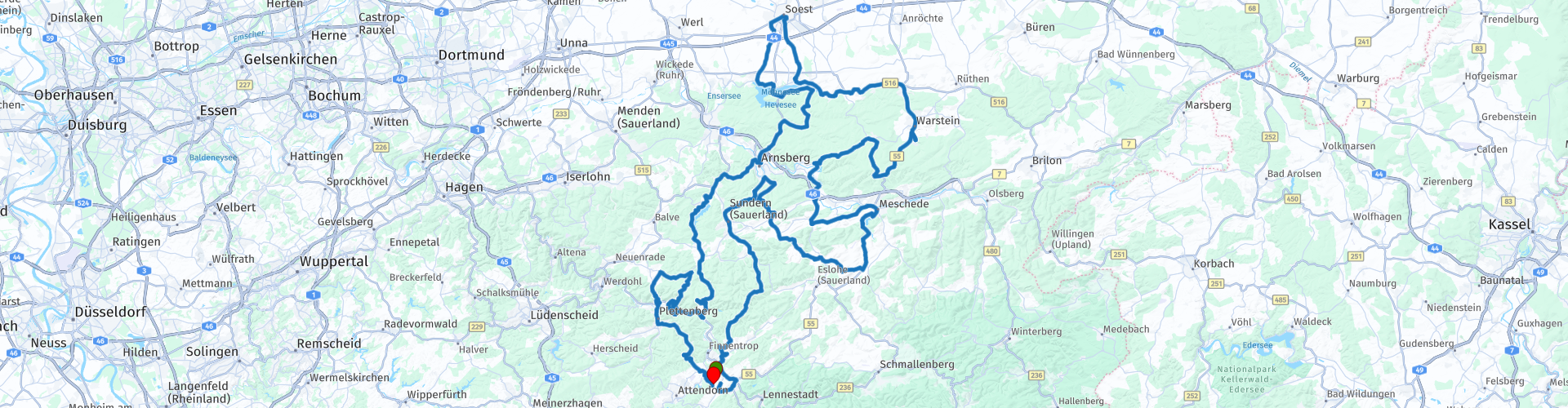
D Roundtrip Silbecke Meschede Moehnesee Soest Sorpesee

This route was brought to you by:
RouteXpert René Plücken (MRA Master)
Last edit: 20-08-2025
 Route Summary
 Sauerland is known as the land of a thousand mountains so you have enough challenge. You drive through undulating landscapes with long, then sharp bends. One mountain top you go up via challenging hairpin bends, the next is simpler and easier, so a lot of variety.
There are many overnight accommodations in Sauerland, which are mainly aimed at motorcyclists with a lot of service and very good gastronomy. There are hotels, holiday homes and guesthouses. The owners themselves are often also fervent motor enthusiasts so they know what you need.
The Sauerland has a very varied landscape that consists for the most part of low mountain ranges with peaks of over 840 meters and deep valleys in between. This makes for many beautiful routes to ride. The asphalt is generally of very good quality.
There are vast forests, grassy meadows, crystal clear streams, rivers and inviting reservoirs. In the Sauerland there are five large reservoirs; the Sorpesee, Hennesee, Biggesee, Diemelsee and the Möhnesee. In addition to this beautiful nature, there is also much to experience in the cultural field in the picturesque villages, the bustling towns, the majestic castles and mysterious ruins.
This route runs over beautiful roads with the necessary bends, long turns and sharp hairpin bends. You pass a number of mountain lakes and dams. These are nice places to stop for a photo.
Please note that some roads are closed to motorcyclists at weekends, this is included in the route with directions for a diversion.
I rate this route is worth 5 stars.
 Share this route


Animation

Verdict


Duration
10h 15m

Mode of travel
Car or motorcycle

Distance
286.23 km

Countries

 RouteXpert Review
 It is a popular holiday area and the area is very busy on weekends and high season, keep this in mind, also that some roads in Sauerland are closed to motorcyclists on weekends. In this route there is a closed road, this is included with directions for a diversion, if you ride it on the weekend.
The route starts from our holiday home in Silbecke, depending on your starting point you can adjust the route. We drive to Lennestadt, where we fill up the bikes for this day, the total distance is about 280 km and there is a second fuel stop planned after about 160 km.
We drive along the banks of the river Lenne, passing the Bamenohl hydroelectric power station built between 1921 and 1923. The water is led to the power station via a 2 kilometre long upper course. In 2011 and 2014 large parts of this historic upper course were replaced by a concrete channel. In 2014 a fish ladder was built at the weir at the beginning of the upper ditch, allowing fish and macrozoobenthos (organisms that live in and on the riverbed) to migrate. The two Francis turbines with a capacity of 6.3 m³/s each have been largely preserved in their original state. The average head in the power station is around 7.2 metres. An average of 2.2 million kWh of electricity is generated annually.
We continue north on beautiful winding roads through the Sauerland. Between Sundern and Gierskampen the road is closed for motorcycles on Saturdays and Sundays and you have to drive from Sundern via Westenfeld to Altenhellenfeld. Directions are in the route.
We drive along the Hennetal reservoir, between the trees you will occasionally see a sparkle of the aqua blue water. Along the route are a number of small parking places if you want to stop to take pictures.
We drive over the winding L735 to the town of Warstein where you can visit the Warsteiner brewery in the Waldpark. This is one of the most modern breweries in Europe and was deliberately designed as a visitor-friendly brewery from the start. The Warsteiner World is the visitor center next to the brewery. Here you can learn everything about the company and its products, this is also the starting point of the visitor railway to explore the brewery. The multilingual brewery tour takes about 75 minutes and is offered in German, English and Dutch. Admission is € 24.50. More information about Warsteiner World can be found in the link in this review.
Via the town of Belecke we drive to the Möhnesee, a large reservoir. We stop briefly at the Kanzelbrücke, this old stone bridge spans the Möhnesee between the districts of Völlinghausen and Wamel. The bridge was built in 1912 and is not only the oldest bridge over the Möhne, but is also considered one of the most beautiful stone bridges in Germany. The structure, also known as the Wamel Bridge, is modeled after old German river bridges.
The bridge owes its name to the design of the pillars, which resemble church pulpits. The picturesque pulpit bridge consists of five arches and is approximately 60 metres long. It was built of greywacke and sandstone. The bridge is only accessible to pedestrians and cyclists.
The quarry stone wall is the main attraction of the Möhne and is over 100 years old. In the year it was put into operation, it was the largest dam in Europe. During the Second World War, the wall was destroyed by a British bombing raid. Almost 1,600 people lost their lives as a result of the flood wave that swept along the Möhne far into the Ruhr area. The reconstruction was completed on 3 October 1943.
We visit the historic town of Soest with its picturesque alleys and shops, Romanesque and Gothic churches, cozy Biergarten and an almost completely preserved “Wallmauer”, a tree-lined city wall, this is one of two remaining in Europe, the other is in Tuscany Italy. Enjoy lunch in one of the restaurants.
From Soest we drive south back to the Möhnemeer, we stop at the Möhnetal Staumauer (Damm). It is a short walk from the parking lot. The quarry stone dam wall is the main attraction of the Möhne and is already more than 100 years old. In the year it was put into operation it was the largest dam in Europe. During WWII the wall was destroyed by a British bombardment. Almost 1600 people lost their lives due to the flood wave that swept along the Möhne far into the Ruhr area. The reconstruction was completed on October 3, 1943. From the dam you have a beautiful view over this impressive reservoir.
We cross the Möhnemeer via the Delecker bridge and drive a bit along the banks to the east and then drive south to Arnsberg. From Arnsberg it is about a 15 minute drive to the next Sorpe reservoir. Plan a break at Biker Treff, a popular place for motorcyclists to stop. There are many motorcycle parking spaces (not free). Enjoy the view over the reservoir here, walk to the dam. If you like a delicious Greek meal, you can go to restaurant Stavros.
We drive along the banks of the Sorpe reservoir to the south, at Rönkhausen you have 2 options to drive back to Silbecke. The short route is left via Finnentrop to Silbecke, this shortens the route by 35 km and 40 minutes. We turn right and meander over the L619 and L697 via Plettenberg back to Silbecke.


 Links
Links  Usage
Usage Want to download this route?
You can download the route for free without MyRoute-app account. To do so, open the route and click 'save as'. Want to edit this route?
No problem, start by opening the route. Follow the tutorial and create your personal MyRoute-app account. After registration, your trial starts automatically.  Disclaimer
Use of this GPS route is at your own expense and risk. The route has been carefully composed and checked by a MyRoute-app accredited RouteXpert for use on TomTom, Garmin and MyRoute-app Navigation.
Changes may nevertheless have occurred due to changed circumstances, road diversions or seasonal closures. We therefore recommend checking each route before use.
Preferably use the route track in your navigation system. More information about the use of MyRoute-app can be found on the website under 'Community' or 'Academy'.

North Rhine-Westphalia
About this region
North Rhine-Westphalia (German: Nordrhein-Westfalen, pronounced [ˌnɔʁtʁaɪn vɛstˈfaːlən] (listen); Low Franconian: Noordrien-Wesfale; Low German: Noordrhien-Westfalen; Colognian: Noodrhing-Wäßßfaale), commonly shortened to NRW (German: [ɛnʔɛʁˈveː] (listen)), is a German state (Land) in Western Germany. With more than 17.9 million inhabitants, it is the most populous state of Germany. Covering an area of 34,084 square kilometres (13,160 sq mi), it is the fourth-largest German state by size. Apart from the city-states, it is also the most densely populated state in Germany.
North Rhine-Westphalia features 30 of the 81 German municipalities with over 100,000 inhabitants, including Cologne (over 1 million), the state capital Düsseldorf, Dortmund and Essen (all about 600,000 inhabitants) and other cities predominantly located in the Rhine-Ruhr metropolitan area, the largest urban area in Germany and the third-largest on the European continent. The location of the Rhine-Ruhr at the heart of the European Blue Banana makes it well connected to other major European cities and metropolitan areas like the Randstad, the Flemish Diamond and the Frankfurt Rhine-Main Region.
North Rhine-Westphalia was established in 1946 after World War II from the Prussian provinces of Westphalia and the northern part of Rhine Province (North Rhine), and the Free State of Lippe by the British military administration in Allied-occupied Germany and became a state of the Federal Republic of Germany in 1949. The city of Bonn served as the federal capital until the reunification of Germany in 1990 and as the seat of government until 1999.
Culturally, North Rhine-Westphalia is not a uniform area; there are significant differences, especially in traditional customs, between the Rhineland region on the one hand and the regions of Westphalia and Lippe on the other. The state has always been Germany's powerhouse with the largest economy among the German states by GDP figures.
Read more on Wikipedia
North Rhine-Westphalia features 30 of the 81 German municipalities with over 100,000 inhabitants, including Cologne (over 1 million), the state capital Düsseldorf, Dortmund and Essen (all about 600,000 inhabitants) and other cities predominantly located in the Rhine-Ruhr metropolitan area, the largest urban area in Germany and the third-largest on the European continent. The location of the Rhine-Ruhr at the heart of the European Blue Banana makes it well connected to other major European cities and metropolitan areas like the Randstad, the Flemish Diamond and the Frankfurt Rhine-Main Region.
North Rhine-Westphalia was established in 1946 after World War II from the Prussian provinces of Westphalia and the northern part of Rhine Province (North Rhine), and the Free State of Lippe by the British military administration in Allied-occupied Germany and became a state of the Federal Republic of Germany in 1949. The city of Bonn served as the federal capital until the reunification of Germany in 1990 and as the seat of government until 1999.
Culturally, North Rhine-Westphalia is not a uniform area; there are significant differences, especially in traditional customs, between the Rhineland region on the one hand and the regions of Westphalia and Lippe on the other. The state has always been Germany's powerhouse with the largest economy among the German states by GDP figures.
View region
 Statistics
  140
140Amount of RX reviews (North Rhine-Westphalia)
 79271
79271Amount of visitors (North Rhine-Westphalia)
 34156
34156Amount of downloads (North Rhine-Westphalia)
 Route Collections in this region
 The 10 most beautiful car and motorcycle routes in Limburg
Limburg, who thinks of Limburg, thinks of flan, coal mines, marl and the hill country. The coal mines have been closed for almost 40 years, the last load of coal was brought up from the Oranje-Nassau coal mine in Heerlen on 31 December and, as they say, South Limburg was transformed from Black to Green and unfortunately there is still little left. view of this period.
But not only pie, marl and coal in Limburg, but also a very beautiful province to tour by car or motorcycle and enjoy all the beauty that the province of Limburg has to offer. For this, the MyRoute app RouteXpert has put together a Top 10 of Car and Motorcycle routes for you.
All routes in this collection have been checked and made equal for TomTom, Garmin and MyRoute-app Navigation by a MyRoute-app RouteXpert.
If you think, I have a very nice route that should certainly not be missing from this collection, send it to:
email: routeexpert@myrouteapp.com
Subject: New Route for the Top 10 collection Province of Limburg composed by Hans van de Ven.
The route will then be reviewed and then added to the Top 10.
To make the Top 10 also the Top 10, 1 route will have to disappear from the Top 10, you can indicate this when submitting the new route.
Have fun with this collection and while driving one of these routes. Enjoy all the beauty that the Netherlands and in particular the province of Limburg has to offer. Click on “View route” to read the review of the chosen route.
I would like to hear your findings about the route(s).
View Route Collection
Top 5 Car and Motorcycle Routes in the Eifel
The Eifel is the eastern part of the medium plateau Eifel-Ardennes. It is located north of the Moselle and west of the Rhine. The largest part is in Germany, a small part is in Belgium, in the East Cantons. The German part of Eifel is located in the federal states of North Rhine-Westphalia and Rhineland-Palatinate. The highest point is the Hohe Acht with 747 meters.
Several chains can be distinguished in the Eifel:
The northernmost part is called the Nordeifel, which in Belgium connects to the High Fens;
To the east of this is the Ahrgebirge, this part is located north of the Ahr in the Ahrweiler district;
South of the Ahr is the Hohe Eifel (or Hocheifel), of which the Hohe Acht (747 m) is the highest point, and also the highest point in the entire Eifel region;
To the west, near the Belgian border, the hills are known as Schneifel, part of the wider Snow Eifel area with peaks reaching up to 698 metres;
South and east of the Hohe Eifel is the Volcano-Eifel, a volcanic area with many crater lakes (Maare).
The southern part of the Eifel is less high. The area is bisected by streams and rivers running southwards. These streams flow into the Moselle. The largest of these rivers is the Kyll; the hills around this river are known as the Kyllwald;
In the south, the Eifel ends in the Voreifel.
In the north of the Eifel there are some large reservoirs. The largest of these is the reservoir in the Roer that was created by the construction of the Roerdal dam.
The Nürburgring is also located in the Eifel, a well-known car circuit for Formula 1 races, among other things. Since 2004, part of the north of the Eifel has become the Eifel National Park. This National Park falls entirely within the German-Belgian nature park High Fens-Eifel. Another part of the Eifel falls within the South Eifel Nature Park.
Well-known throughout the Netherlands and Belgium by car and motorcyclists, so reason enough for the MyRoute app RouteXpert to compile a Top 5 of Car and Motorbike routes for you.
All routes in this collection have been checked and made equal for TomTom, Garmin and MyRoute-app Navigation by a MyRoute-app RouteXpert.
If you think, I have a very nice route that should certainly not be missing from this collection, send it to:
email: routeexpert@myrouteapp.com
Subject: New Route for the Top 5 collection Eifel composed by Hans van de Ven.
The route will then be reviewed and then added to the Top 5. To make the Top 5 also the Top 5, 1 route will have to disappear from the Top 5, you can indicate this when submitting the new route.
Have fun with this collection and while driving one of these routes. Enjoy all the beauty that the Eifel has to offer. Click on “View route” to read the review of the chosen route.
I would like to hear your findings about the route(s).
View Route Collection