Roundtrip Ypres via Ruisseauville

This route was brought to you by:
RouteXpert Catherine De Groote RouteXpert
Last edit: 08-01-2021
 Route Summary
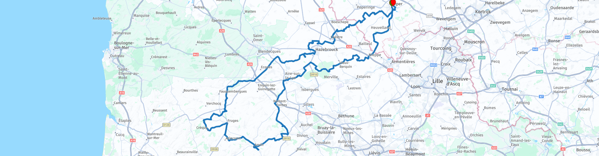
 Beautiful roads, beautiful views and nature. You pass a few war memorials from World War II. It is a very rural route. Only in the surroundings of Aire-sur-la-Lys is it reasonably busy.
We ended the ride by attending the Last Post at the Menin Gate in Ypres. This takes place every day at 8 p.m.
 Share this route


Animation

Verdict


Duration
5h 51m

Mode of travel
Car or motorcycle

Distance
227.97 km

Countries


 RouteXpert Review
 I give the route 4.5 stars because it is very quiet and the courses look really good. There is also a lot to see. Only on the way back is there a busier part, so that this route still gets half a point less.
We leave Ypres in the direction of Reningelst to cross the French border a little further. We pass the French-Flemish villages Boeschepe and Godewaersvelde and drive around Hazebrouck.
This region has largely retained its Flemish character. There are traces of the Flemish architecture that was so characteristic of the region's past richness in almost every village: churches, cathedrals, belfries, hall towers.
Just past Hazebrouck (rp 21) you will find 'La Base de lancement the V1 du bois des Huit-Rues' on the left. This was built by Nazi Germany in 1943 and served as a launching platform for V1 rockets aimed at London and the south of England. There is a parking at the start of the walkway to the bunkers and launch installation. The installation is located in the woods and is accessible via a well-maintained path. More information can be found on the website (see link below this review).
The route takes us further along quiet small lanes to the D190, which we follow for 12 km to Thérouanne. From here we choose the narrower and quiet courses to fully enjoy the landscape. In Ruisseauville we are at the farthest point and a few kilometers further we turn back north.
The area around Aire-sur-la-Lys is busier. There is more habitation and more traffic. Once past Thiennes everything becomes quiet again.
We drive back into Belgium in the Bailleul area.
Just before Kemmel (rp 55) we pass the Command Bunker of Kemmel. This is a large military underground bunker built as a result of the Cold War. The whole is now furnished as a Museum of the Cold War and housed in the Historical Pool of Defense. There is a small parking but you can also park along the road. The bunker has limited opening hours and admission tickets must be purchased at the Tourist Office in Kemmel. All info with opening times and prices can be found in the link under the review.
At Wijtschate (rp 57) we pass the Dietrich shaft. This is a vertical listening shaft - built by the Germans in the Kamptebos van Wijtschate. You reach the Dietrich shaft via the cart track to the Kampagne forest. Follow the forest path and you will find the Dietrich shaft after about 100 m on your left.
Not so far from there you will pass Bayernwald on your right (rp 59). This is definitely worth a visit. Bayernwald shows a piece of a German trench system. The German troops conquered this place on the French in 1914 and christened the "Bayernwald" site. Here you will also find two listening shafts. The German soldiers feared British deep mines and thanks to these corridors they could monitor the enemy activities. Bayernwald has been reconstructed on the basis of archaeological research and shows you 10% of the original construction from WWI. To visit this trench system, visitors must first register at the Tourist Office in Kemmel (see link below this review).
And so we come back along the Menin Gate to our starting point Ypres.
The Menin Gate is a memorial monument. It was built by the British in 1927 on the east side of the city, in memory of the approximately 54,900 British soldiers who fell in the First World War and were no longer identified or recovered. The name refers to the city of Menen, a city that can be reached from Ypres Center via the Menin Gate.
Near the Menin Gate you have Pizzeria Babilonia. At this restaurant (or one of the many other restaurants in the city) you can end the day with a well-earned meal.


 Links
Links  Usage
Usage Want to download this route?
You can download the route for free without MyRoute-app account. To do so, open the route and click 'save as'. Want to edit this route?
No problem, start by opening the route. Follow the tutorial and create your personal MyRoute-app account. After registration, your trial starts automatically.  Disclaimer
Use of this GPS route is at your own expense and risk. The route has been carefully composed and checked by a MyRoute-app accredited RouteXpert for use on TomTom, Garmin and MyRoute-app Navigation.
Changes may nevertheless have occurred due to changed circumstances, road diversions or seasonal closures. We therefore recommend checking each route before use.
Preferably use the route track in your navigation system. More information about the use of MyRoute-app can be found on the website under 'Community' or 'Academy'.