TTT 2008 03 Rondje Monschau

This route was brought to you by:
RouteXpert Hans van de Ven (Mr.MRA)
Last edit: 17-03-2019
 Route Summary
 The 173 ANWB Promoter TankTasTocht (TTT) were scanned by Henry ten Dam and signed by Leon Stolk in Mapsource and later placed as a Track in a .gpx file. These have been made available through the MrGPS website with the approval of the ANWB Promoter so that everyone can enjoy it. The 1st TTT is from 1992, so the route may differ slightly from the original.
I have checked all route points and, where necessary, placed them neatly on the road. Also, if necessary, I have further spaced the start point and end point of the route to avoid navigating directly to the end point, and I added the POI files from the start and end point just like a possible stop.
Finally, I made the route the same for TomTom, Garmin and MyRoute-app Navigation users.
Thanks to Henry, Leon, MrGPS and Promoter.
 Share this route


Animation

Verdict


Duration
4h 42m

Mode of travel
Car or motorcycle

Distance
205.60 km

Countries


 RouteXpert Review
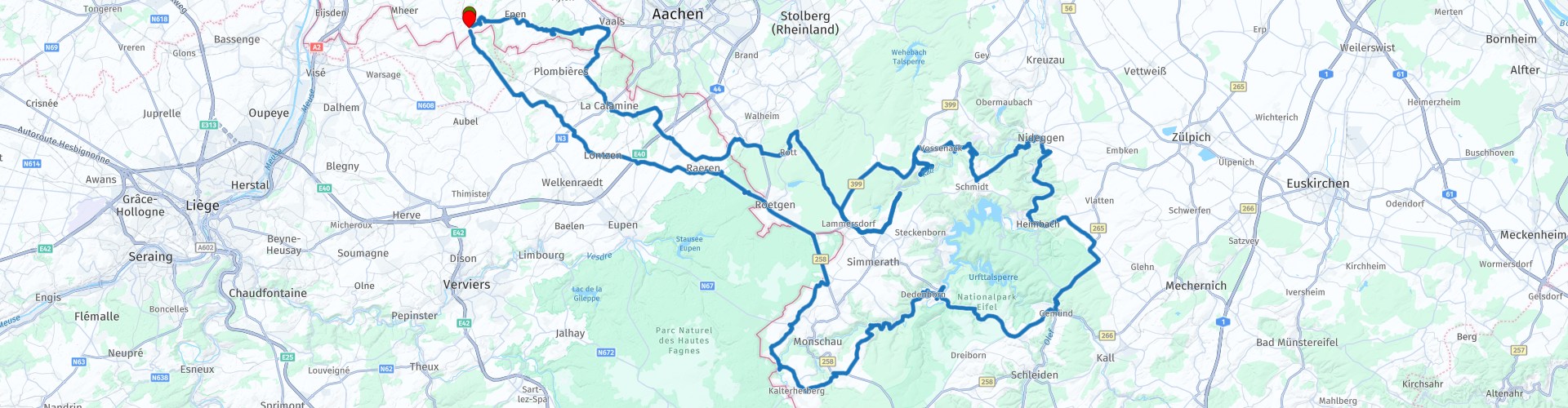
 Via the 3-country point in Vaals you cross the border to Belgium to drive via Gemmenich to the Eiel, once in Germany you set course for the Hürtgenwald * for coffee in Simonskall.
* The Battle of the Hürtgenwald was a battle that took place during the Second World War between September 1944 and February 1945 in the Aachen area. At the end of the Second World War, fierce fighting took place in the area between the High Fens and the Roer. These fights have never received the same prominence as the Ardennes Offensive. The battle of the Hürtgenwald took place in the period between mid-September 1944 and February 1945.
In this area lay the Siegfried line or Westwall, which consisted of two lines of defense at this location. The Westwall was a succession of bunkers, concrete tank barriers (also called dragon teeth), machine gun nests, barbed wire barriers and minefields. (Source: Wikipedia).
After the coffee you will happily continue your stroll through the Eifel, where you have the opportunity to visit the former camp Vogelsang **.
** The NS-Ordensburg Vogelsang is a former training camp of the NSDAP in the German Eifel, near the Belgian border in the German state of North Rhine-Westphalia. After the war it became a military training ground and since 2006 Vogelsang IP can be visited as an "International Place" for tolerance, diversity and peaceful togetherness.
Also, on the way back to Slenaken, first pass Monschau ***, where you soon cross the border with Belgium towards the Netherlands.
*** Monschau is a town in the German state of North Rhine-Westphalia, located at an altitude of around 420 meters in the Aachen City Region. It lies on the edge of the Eifel on the upper reaches of the Roer. (Source: Wikipedia).
Because I have driven this route myself, this route gets 5 stars.
Route details:
rp 14 - Coffee stop at Landhotel Kallbach in Simonskall.
rp 21 - Possibility to visit Camp Vogelsang.
Not a specific lunch location indicated in this route, because you have enough options along the way to stop for something to eat and / or drink.


 Links
Links  Usage
Usage Want to download this route?
You can download the route for free without MyRoute-app account. To do so, open the route and click 'save as'. Want to edit this route?
No problem, start by opening the route. Follow the tutorial and create your personal MyRoute-app account. After registration, your trial starts automatically.  Disclaimer
Use of this GPS route is at your own expense and risk. The route has been carefully composed and checked by a MyRoute-app accredited RouteXpert for use on TomTom, Garmin and MyRoute-app Navigation.
Changes may nevertheless have occurred due to changed circumstances, road diversions or seasonal closures. We therefore recommend checking each route before use.
Preferably use the route track in your navigation system. More information about the use of MyRoute-app can be found on the website under 'Community' or 'Academy'.