TTT 2010 04 Eifel D1 Asten Manderscheid

This route was brought to you by:
RouteXpert Hans van de Ven (Mr.MRA)
Last edit: 20-07-2020
 Route Summary
 The 173 ANWB Promoter TankTasTocht (TTT) were scanned by Henry ten Dam and signed by Leon Stolk in Mapsource and later placed as a Track in a .gpx file. These are made available through the MrGPS website with the approval of the ANWB Promoter so that everyone can enjoy them. The 1st TTT is from 1992, so the route may differ slightly from the original.
I have checked all route points and, where necessary, placed them neatly on the road. Also, if necessary, I have further spaced the start point and end point of the route to avoid navigating directly to the end point, and I added the POI files from the start and end point just like a possible stop.
Finally, I made the route the same for TomTom, Garmin and MyRoute-app Navigation users.
Thanks to Henry, Leon, MrGPS and Promoter.
 Share this route


Animation

Verdict


Duration
6h 58m

Mode of travel
Car or motorcycle

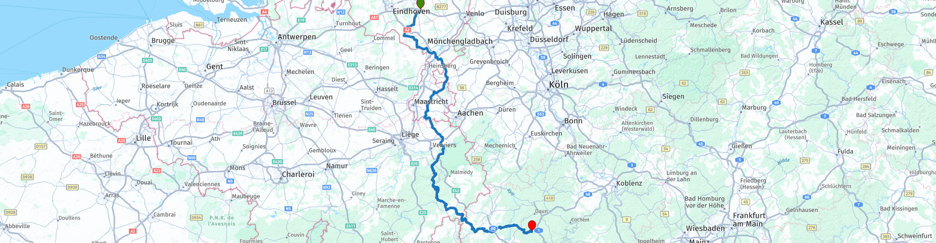
Distance
323.43 km

Countries


 RouteXpert Review
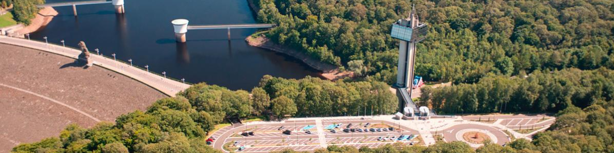
 * The Gileppe dam (French: barrage de la Gileppe) is a dam in the Belgian province of Liège, in the municipalities of Jalhay and Baelen. The supply of water is assured by the Gileppe that originates in the High Fens.
After lunch it continues through the Ardennes towards Coo, where you have the option to refuel on the route. After the possible fuel stop, it continues towards the 3-country point (Belgium - Germany - Luxembourg), where you cross the border with Germany again to pause at Pension Froschloch, where the Dutch are in charge. This is also the last stop before you arrive at the terminus in Manderscheid, namely Hotel Am Ceresplatz, which is also run by Dutch people. Just before you reach the hotel you can refuel, so that you can leave the next day with a full tank.
Because I have driven this route myself, this route gets 5 stars.
Route details:
The route has been made the same for TomTom, Garmin and MyRoute-app Navigation users. That has been successful everywhere except in Animals between route points 29 and 30 (Purple), where TomTom and Garmin disagree. Not a big problem, if you drive alone you just follow the instructions of your GPS, if you drive in a group then you follow the driver. From route point 30 the two come together again and your GPS will follow the route correctly again.
Stopping places:
rp 20 - Coffee stop at Restaurant Ratsstube
rp 41 - Lunch stop at Restaurant du Lac de la Gileppe
rp 46 - Tank option at Q8 in Coo
rp 53 - Coffee stop at Pension Froschloch
rp 64 - Refueling in Manderscheid.


 Links
Links  Usage
Usage Want to download this route?
You can download the route for free without MyRoute-app account. To do so, open the route and click 'save as'. Want to edit this route?
No problem, start by opening the route. Follow the tutorial and create your personal MyRoute-app account. After registration, your trial starts automatically.  Disclaimer
Use of this GPS route is at your own expense and risk. The route has been carefully composed and checked by a MyRoute-app accredited RouteXpert for use on TomTom, Garmin and MyRoute-app Navigation.
Changes may nevertheless have occurred due to changed circumstances, road diversions or seasonal closures. We therefore recommend checking each route before use.
Preferably use the route track in your navigation system. More information about the use of MyRoute-app can be found on the website under 'Community' or 'Academy'.
;_vue_de_la_partie_occidentale_du_château-fort_(XIIIe–XIX_siècles).jpg/1280px-Bouillon_(Belgique);_vue_de_la_partie_occidentale_du_château-fort_(XIIIe–XIX_siècles).jpg)
Luxembourg
About this region
Luxembourg (French: Luxembourg [lyksɑ̃buʁ] (About this soundlisten); Dutch: Luxemburg [ˈlyksəmˌbʏrx] (About this soundlisten); German: Luxemburg [ˈlʊksəmbʊʁk] (About this soundlisten); Luxembourgish: Lëtzebuerg; Walloon: Lussimbork), also called Belgian Luxembourg, is the southernmost province of Wallonia and of Belgium. It borders on the country of Luxembourg to the east, the French departments of Ardennes, Meuse and Meurthe-et-Moselle to the south and southwest, and the Walloon provinces of Namur and Liège to the north. Its capital and largest city is Arlon (Luxembourgish: Arel, Dutch: Aarlen), in the south-east of the province.
It has an area of 4,459 km2 (1,722 sq mi), making it the largest Belgian province. With around 285,000 residents, it is also the least populated province, with a density of 64/km2 (170/sq mi), making it a relatively sparsely settled part of a very densely populated region.
It is significantly larger (70%), but much less populous than the neighbouring Grand Duchy of Luxembourg. About eighty percent of the province is part of the densely wooded Ardennes region. The southernmost region of the province is called Gaume or Belgian Lorraine (main city: Virton).
The Arelerland or Arlon region (in red on the map of arrondissements, below) bordering the neighbouring Grand-Duchy of Luxembourg has the particularity that many of its residents have historically spoken Luxembourgish, a language closely related to German, rather than the French or Walloon spoken elsewhere in the province.
The province was separated from the neighbouring Luxembourg by the Third Partition of Luxembourg, de jure in 1830–31 by the Conference of London dealing with the consequences of the Belgian Revolution of 1830, de facto in 1839, after William I, King of the Netherlands and Grand-Duke of Luxembourg, agreed to its decisions and thus the province was given to the newly created Kingdom of Belgium.
Read more on Wikipedia
It has an area of 4,459 km2 (1,722 sq mi), making it the largest Belgian province. With around 285,000 residents, it is also the least populated province, with a density of 64/km2 (170/sq mi), making it a relatively sparsely settled part of a very densely populated region.
It is significantly larger (70%), but much less populous than the neighbouring Grand Duchy of Luxembourg. About eighty percent of the province is part of the densely wooded Ardennes region. The southernmost region of the province is called Gaume or Belgian Lorraine (main city: Virton).
The Arelerland or Arlon region (in red on the map of arrondissements, below) bordering the neighbouring Grand-Duchy of Luxembourg has the particularity that many of its residents have historically spoken Luxembourgish, a language closely related to German, rather than the French or Walloon spoken elsewhere in the province.
The province was separated from the neighbouring Luxembourg by the Third Partition of Luxembourg, de jure in 1830–31 by the Conference of London dealing with the consequences of the Belgian Revolution of 1830, de facto in 1839, after William I, King of the Netherlands and Grand-Duke of Luxembourg, agreed to its decisions and thus the province was given to the newly created Kingdom of Belgium.
View region
 Statistics
  41
41Amount of RX reviews (Luxembourg )
 29231
29231Amount of visitors (Luxembourg )
 9502
9502Amount of downloads (Luxembourg )
 Route Collections in this region
 Route collection MRA NAVIGATION GRAND TOUR 2019
MRA NAVIGATION GRAND TOUR 2019 in short:
From 2019, MyRoute-app organizes every year the "MyRoute-app Navigation Grand Tour" exclusively for MyRoute-app Navigation users. During the Grand Tour you drive 4 routes during the calendar year. A few commands are included in each route. Participants who capture all 4 tracks via MyRoute-app Navigation have the chance to win a great prize. In 2019 we had chosen the 2nd World War as the theme for the 4 routes.
The routes and the assignments:
As mentioned, the theme of 2019 was the 2nd World War. A loaded theme, you are confronted with the dual nature of humanity; the willingness to kill for an ideology, we are better than them, cruelty, slaughter, but also heroism and sacrifices, would it ever change? I myself am very interested in world history, I have even studied it for a year at the university and certainly the 1st and 2nd world war have my interest. So it was no task to put together the routes, drive yourself and come up with the assignments.
Have fun driving these beautiful and interesting routes with a loaded theme!
View Route Collection
5 tours in Belgium in flat Flanders the hills of the Pays des Collines and the Ardennes
Those who like a winding and hilly course, along many small lanes with little to no traffic, will certainly find what they are looking for in the Pays des Collines, the region east and south of Ronse.
Between Diksmuide and Ypres there are many commemorative monuments of the First World War. In Vinkt in East Flanders, the monument commemorates the massacre that took place in May 1940.
Along rural quiet roads you can taste the history of World War I and II.
Marche-en-Famenne is an excellent starting point to thoroughly explore this plateau, which is cut by rivers and strewn with coniferous forests. The real Ardennes are the most hilly areas of Belgium behind the Meuse. Nature plays an all-important role on this trip.
In addition to the Ardennes, the route with start and end point in Huy also goes through a part of Condroz and Famenne. The Condroz, where wooded hills and valleys alternate, and the Famenne, which makes the transition to the Ardennes plateaus. In the summer it is wonderful motorcycling in the vast forests. You will not only enjoy the natural beauty, but you will also pass numerous castles, wild flowing Ardennes rivers, quiet villages and authentic tourist towns.
The tour from Namur runs through the Meuse area where you discover that the tributaries of the Meuse are of picturesque beauty. You will pass a large number of castles and fortresses. The roads along the Maas are busy arterial roads. But as soon as you can you will look for the smaller roads that are immediately a lot quieter and take us through forests and meadows.
View Route Collection