TTT 2011 06 Linge Betuwe

This route was brought to you by:
RouteXpert Hans van de Ven (Mr.MRA)
Last edit: 11-05-2019
 Route Summary
 The 173 ANWB Promoter TankTasTocht (TTT) were scanned by Henry ten Dam and signed by Leon Stolk in Mapsource and later placed as a Track in a .gpx file. These have been made available through the MrGPS website with the approval of the ANWB Promoter so that everyone can enjoy it. The 1st TTT is from 1992, so the route may differ slightly from the original.
I have checked all route points and, where necessary, placed them neatly on the road. Also, if necessary, I have further spaced the start point and end point of the route to avoid navigating directly to the end point and I added the POI files from the start and end point just like a possible stop point.
Finally, I made the route the same for TomTom, Garmin and MyRoute-app Navigation users.
Thanks to Henry, Leon, MrGPS and Promoter.
 Share this route


Animation

Verdict


Duration
3h 34m

Mode of travel
Car or motorcycle

Distance
118.63 km

Countries

 RouteXpert Review
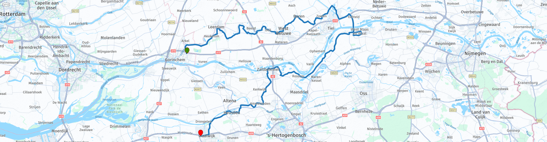
 * De Linge is a river that flows from Doornenburg to Gorinchem in the Betuwe. Large parts of the Linge are not navigable by motorized ships. The municipalities of Lingewaard and Lingewaal derive their name from the Linge.
** The Betuwe is a region in the Dutch province of Gelderland, located between the rivers Waal in the south and the Lower Rhine and Lek in the north. The Betuwe region consists of three parts: the Over-Betuwe; the Lower Betuwe and the Tielerwaard. (Source: Wikipedia).
Immediately after departure you look up the Linge and continue to follow it via the south side to Geldermalsen. In Geldermalsen you cross the Linge to drive via Buren, Kerk Avezaath, Zoelen and Echteld to Beneden-Leeuwen where you have the opportunity to have lunch.
After lunch, head for the Waal and continue to follow it until you reach Zaltbommel and then head down to Ammerzoden, where you cross the Maas and arrive almost immediately in the fortress of Heusden ***.
*** The fortified city arose around one of the oldest moated castles in north-west Europe and was one of the first Dutch cities to be surrounded by a wall. After 1968 the city was thoroughly restored. The starting point was the map of Blaeu from 1649. The fortifications and the muted city harbor have been restored to their former glory. With the restoration, Heusden won the highest European restoration prize 'Europa Nostrae' in 1980. On top of the ramparts of the fortified city of Heusden you have a beautiful view over the Brabant and Gelderland landscape, the Bergsche Maas and the restored city.
After Heusden you continue to follow the Bergsche Maas **** and then arrive at the end point, McDonalds Waalwijk.
**** The Bergsche Maas is a dug river in North Brabant that forms the continuation of the Maas, and changes its name further into the Amer. The Bergsche Maas originated when in 1904 the Maas was continued from Well in a westerly direction to the west. (Source: Wikipedia).
Because I have driven large parts of this route myself, this route gets 4 stars.
Route details:
rp 29 - Lunch stop at De Bever in Beneden-Leeuwen
At route point 51 (Purple), ferry crossing Bern - Heusden, I used the "Skip route point" option to avoid unnecessary detours on the Here map.


 Links
Links  Usage
Usage Want to download this route?
You can download the route for free without MyRoute-app account. To do so, open the route and click 'save as'. Want to edit this route?
No problem, start by opening the route. Follow the tutorial and create your personal MyRoute-app account. After registration, your trial starts automatically.  Disclaimer
Use of this GPS route is at your own expense and risk. The route has been carefully composed and checked by a MyRoute-app accredited RouteXpert for use on TomTom, Garmin and MyRoute-app Navigation.
Changes may nevertheless have occurred due to changed circumstances, road diversions or seasonal closures. We therefore recommend checking each route before use.
Preferably use the route track in your navigation system. More information about the use of MyRoute-app can be found on the website under 'Community' or 'Academy'.