Torrevieja to Teruel

This route was brought to you by:
RouteXpert Nick Carthew - (MRA Master)
Last edit: 18-08-2025
 Route Summary
  Share this route


Animation

Verdict


Duration
7h 42m

Mode of travel
Car or motorcycle

Distance
377.36 km

Countries

 RouteXpert Review
 Embalse de la Pedrera is a large reservoir located in the province of Alicante. It serves as an important water source for irrigation in the region, supporting local agriculture and it plays a crucial role in water management for the area.
You now head into the open countryside with long distance views of small mountain ranges ahead, and when you pass these, there is another range, and another and another. The road surface is very good and there are some fast sweeping bends that will put a smile on any motorcyclists face.
You will enter the Special Protection Zone for Birds, Yecla Steppes.
The endless landscape of the vast northern plains of the Yecla area constitutes a valuable refuge for some bird species that are threatened throughout Europe. Birds such as great bustard, little bustard, sandgrouse, stone curlew, lesser kestrels and harriers all depend on this type of landscape.
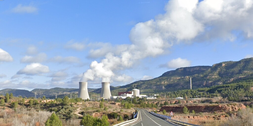
Then as a complete contrast to the natural countryside that surrounds you, you'll come across the Cofrentes Nuclear Power Plant, built on the right bank of the Júcar river, which provides water for cooling. Steam rising from the cooling towers can be seen from miles around. The reactor has Spain's highest net capacity capable of producing 1,064 Megawatts of electricity.
I have suggested a fuel and lunch stop at El Pontón. The La Brassa restaurant is next door to the gas station and they welcome motorcyclists.
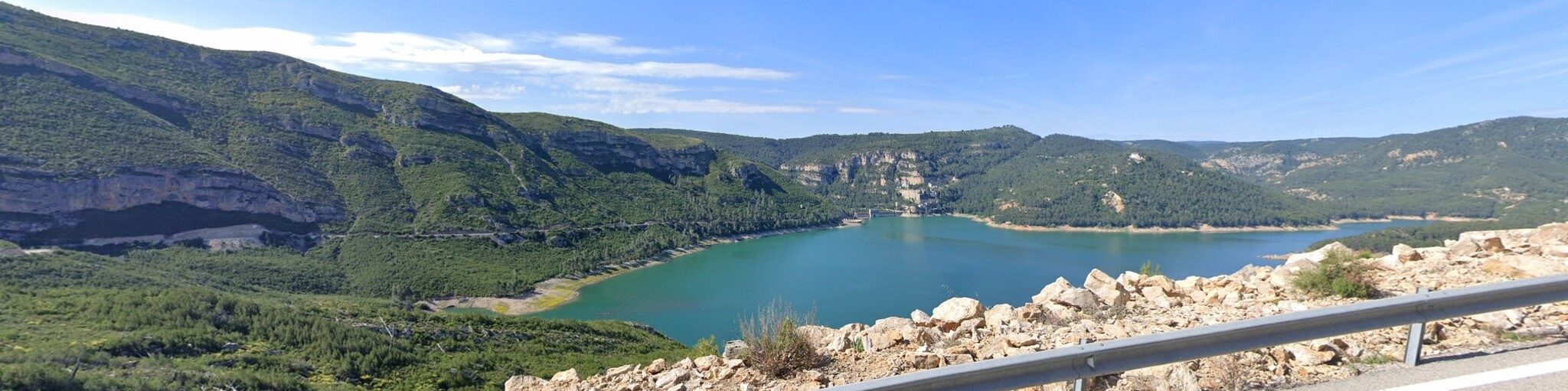
After lunch the route takes a smaller road and heads towards the magnificent Benagéber reservoir. The road is very twisty and has several hairpin bends. There is an opportunity to take pictures on the dam and anyone with a loud exhaust will appreciate the tunnel!
This enormous reservoir is fed by the Rio Turia which we will meet up with again at the Santa Cruz de Moya bridge and follow its path, with more hairpins all the way to the hotel at Teruel.
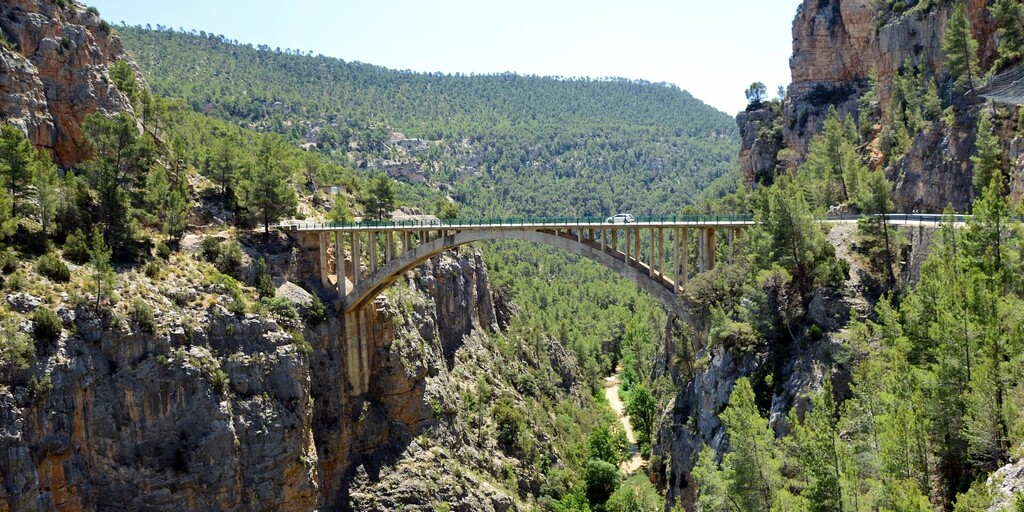
The Santa Cruz de Moya bridge crosses over the Turia River at a spectacular canyon. The bridge consists of an iron arch with four trusses joined together, with a cement formwork . The length of the arch (width of the Turia canyon) is 85 metres and the height is 100 metres above the river bed. Although the structure of the bridge is made of iron, it is completely covered in cement, so that the metal is not visible at all. After crossing the canyon there are no safe places to stop for a photo, but I would certainly try to!
The route ends at the Hotel Isabel de Segura which has 3*** and is very comfortable with secure parking. We stayed here in May 2019, see the link below.
I will also add that the barmaid was very generous with her brandy measures!
Enjoy
 Links
Links  Usage
Usage Want to download this route?
You can download the route for free without MyRoute-app account. To do so, open the route and click 'save as'. Want to edit this route?
No problem, start by opening the route. Follow the tutorial and create your personal MyRoute-app account. After registration, your trial starts automatically.  Disclaimer
Use of this GPS route is at your own expense and risk. The route has been carefully composed and checked by a MyRoute-app accredited RouteXpert for use on TomTom, Garmin and MyRoute-app Navigation.
Changes may nevertheless have occurred due to changed circumstances, road diversions or seasonal closures. We therefore recommend checking each route before use.
Preferably use the route track in your navigation system. More information about the use of MyRoute-app can be found on the website under 'Community' or 'Academy'.

Castilla–La Mancha
About this region
Castilla–La Mancha (UK: , US: , Spanish: [kasˈtiʎa la ˈmantʃa] (listen)), or Castile La Mancha, is an autonomous community of Spain. Comprising the provinces of Albacete, Ciudad Real, Cuenca, Guadalajara and Toledo, it was created in 1982. The government headquarters are in Toledo.
The region largely occupies the southern half of the Iberian Peninsula's Inner Plateau, including large parts of the catchment areas of the Tagus, the Guadiana and the Júcar, while the northeastern relief comprises the Sistema Ibérico mountain massif.
It is bordered by Castile and León, Madrid, Aragon, Valencia, Murcia, Andalusia, and Extremadura. It is one of the most sparsely populated of Spain's regions. Albacete, Guadalajara, Toledo, Talavera de la Reina and Ciudad Real concentrate the largest urban areas in the region.
Read more on Wikipedia
The region largely occupies the southern half of the Iberian Peninsula's Inner Plateau, including large parts of the catchment areas of the Tagus, the Guadiana and the Júcar, while the northeastern relief comprises the Sistema Ibérico mountain massif.
It is bordered by Castile and León, Madrid, Aragon, Valencia, Murcia, Andalusia, and Extremadura. It is one of the most sparsely populated of Spain's regions. Albacete, Guadalajara, Toledo, Talavera de la Reina and Ciudad Real concentrate the largest urban areas in the region.
View region
 Statistics
  13
13Amount of RX reviews (Castilla–La Mancha)
 13485
13485Amount of visitors (Castilla–La Mancha)
 487
487Amount of downloads (Castilla–La Mancha)
 Route Collections in this region
 A 4 day tour in Spain from Bilbao to Cartagena
With a starting point just south of Bilbao, this 1,300 km tour is easy to connect to from the French border or Santander. The tour travels through some of Spain's most spectacular landscapes and visits among other things, the windmills of La Mancha, made famous in the books by Miguel de Cervantes and his character Don Quixote. The end of this 4 day tour is at Cartagena on the Mediterranean's Costa Cálida, a wonderful city that's alive with culture, history and gastronomy.
View Route Collection
A 5-day tour from Peniscola visiting Toledo Merida Avila Segovia Siquenza Barcelona
A 5-route, 5-day tour of Peniscola, Aranjuez, Toledo, Consuegra, Molinos, Merida, Avila, Segovia, seguiranza and Barcelona, taking in these sites will immerse you in the rich history and culture of Spain. From stunning medieval fortresses to charming windmill villages, you will pass through picturesque roads enjoying the exquisite local cuisine and natural beauty that each place has to offer. It will be an unforgettable experience full of discoveries and unforgettable moments. Definitely a trip worth taking!
View Route Collection