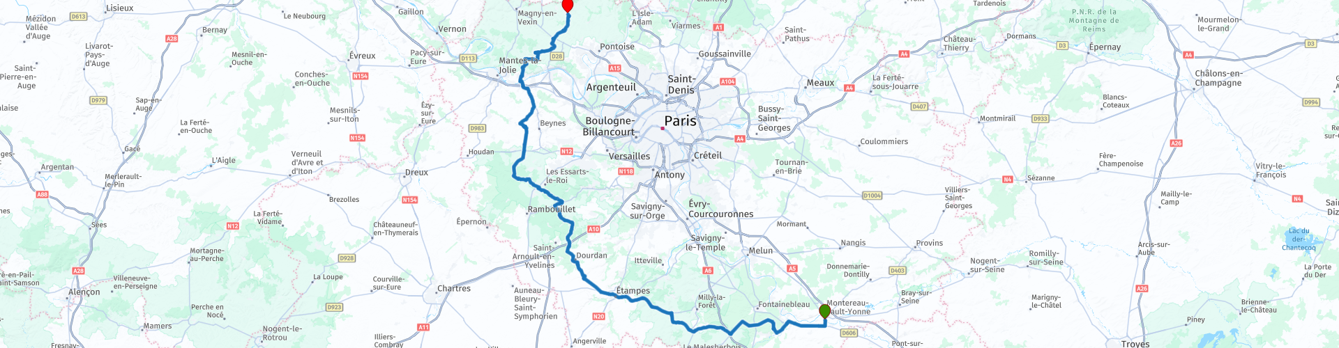
Around Paris from Montereau Fault Yonne to Amblainville

This route was brought to you by:
RouteXpert Nick Carthew - (MRA Master)
Last edit: 01-10-2025
 Route Summary
  Share this route


Animation

Verdict


Duration
5h 26m

Mode of travel
Car or motorcycle

Distance
217.18 km

Countries

 RouteXpert Review
 If you want to bypass Paris as part of a longer journey, this route can be easily joined from the A5, A6 motorways giving you a stress free journey as you travel north.
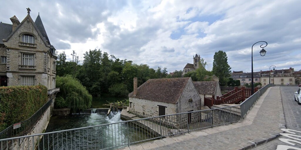
The route will take you over the incredibly picturesque bridge at Moret-sur-Loing where there are two ancient mills. This bridge has featured in many fine works of art, most notably Alfred Sisley, a 19c French born British impressionist landscape artist.
Just after crossing the bridge, you will turn into a street that has a great chocolate shop, cheese shop and bakers where you can stock up on some goodies for a picnic lunch.
You will soon be in the beautiful Fontainebleau Forest and at an area size of 19,200 hectares; it is the second largest national forest in France, and for no apparent reason there are 2 open hairpin bends followed by a series of fast flowing bends that seemed to be designed for motorcyclists :) The bends are known as "Le route de L'escargot" or The Snail Road, this maybe because the shape could resemble two snails head to head!
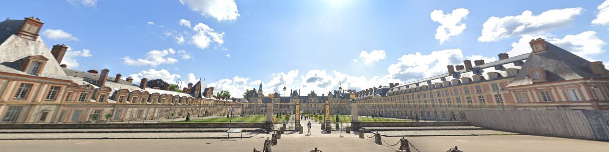
After these bends you go straight on and visit the magnificent Château de Fontainebleau. A view and photo of the outside is enough to tell you that this is a significant building. Since 1981, the Château de Fontainebleau and its domain are designated a UNESCO World Heritage Site. The Château de Fontainebleau was home to virtually all of France's royal families and emperors, from the 12th to the 19th centuries, including Louis VII, Francis I, Henry IV, Louis-Philippe, and the Napoleons. The château was a crucial residence for 34 kings and two emperors, who lived there for extended periods, transforming it into a grand palace.
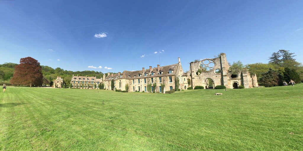
Leaving the forest, the land is very flat and fertile and you will travel through typically French arable countryside, on quiet roads. You will pass through the small town of Étampes and right by a McDonald's where I have suggested a short coffee break before heading towards the Haute Vallée de Chevreuse Regional Natural Park. You will pass the former Cistercien monastery; Abbaye des Vaux de Cernay and even if you don't have time to walk around it, it is only a short detour to take some photo's.
The Etangs de Hollande are a series of artificial ponds created under Louis XIV, at the end of the 17th century, to capture the water of the Rambouillet plateau and contribute to feed the fountains of the park of Versailles. This is one of many good places to stop for your picnic.
The route crosses the mighty river Seine at Épône by using double bridges and then enters the Vexin Français Regional Natural Park, it's picturesque, unspoiled and protected scenery ranges from woods, forests, meadows, fields and hills to marshland, rivers and typical villages, and was a source of inspiration for many Impressionist painters, including Van Gogh, Cézanne and Daubigny. The village of Vigny within the park and the Château de Vigny is where Rihanna made her video for the song "Te Amo".
This route ends at Amblainville where you can join the A16 heading north and carry on with your journey, for instance the Channel Tunnel is only 2 hours 40 minutes away.
I've travelled through Paris in both directions and have suffered the traffic of the notoriously busy Boulevard Périphérique, this route is a much nicer way of going from south to north!
Enjoy
 Links
Links  Usage
Usage Want to download this route?
You can download the route for free without MyRoute-app account. To do so, open the route and click 'save as'. Want to edit this route?
No problem, start by opening the route. Follow the tutorial and create your personal MyRoute-app account. After registration, your trial starts automatically.  Disclaimer
Use of this GPS route is at your own expense and risk. The route has been carefully composed and checked by a MyRoute-app accredited RouteXpert for use on TomTom, Garmin and MyRoute-app Navigation.
Changes may nevertheless have occurred due to changed circumstances, road diversions or seasonal closures. We therefore recommend checking each route before use.
Preferably use the route track in your navigation system. More information about the use of MyRoute-app can be found on the website under 'Community' or 'Academy'.