Rocroi Virton via de route des legendes

This route was brought to you by:
RouteXpert Stijn Claus
Last edit: 09-04-2019
 Route Summary
  Share this route


Animation

Verdict


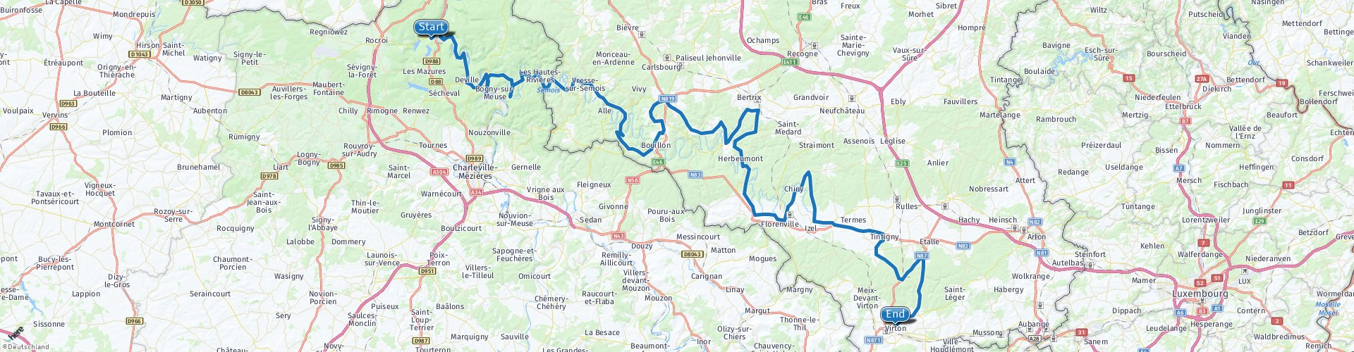
Duration
4h 7m

Mode of travel
Car or motorcycle

Distance
204.96 km

Countries


 RouteXpert Review
 First we cross the French Ardennes from west to east along the banks of the Maas.
Along the way we pass numerous beautiful views to which many stories and legends are linked such as Mont Malgré-Tout (Rp2) with a beautiful panoramic view over the Meuse valley, Les Dames de Meuse (Rp3),
Roc-la-Tour or the Devil's Castle and La Roche à Sept Heures (Rp5) and the statue of the four Aymon brothers (Rp6).
Please note that Roc-la-Tour and La Roche à Sept Heures can only be reached on foot.
A walk of 2 km downstream leads you to Roc-La-Tour and via a narrow hiking trail with many panoramas you can reach La Roche à Sept Heures.
An information panel on the parking informs about the different routes.
After we have exchanged the banks of the Maas for those of the Semois, the road takes us to Belgium in the region around Bouillon. Here the Semois winds through the landscape. This ensures beautiful views over different meanders (Rp 9 and 14), each with its own story.
Near Bouillon (Rp12) we have a view over the medieval castle. The castle is definitely worth a visit. It is also the ideal place to stop for lunch.
After the stop we follow the winding of the Semois further to the Southeast. Along the way we pass the Château de Fées (Rp19), the ruins of a Roman castle and the Feeënspelonk (Rp29), a rocky overhang, pierced with corridors and holes. There are many myths and legends associated with both sights.
The route ends in Virton at the tourism office. From here, the E25 Luxembourg-Liège motorway is easily accessible.


 Links
Links  Usage
Usage Want to download this route?
You can download the route for free without MyRoute-app account. To do so, open the route and click 'save as'. Want to edit this route?
No problem, start by opening the route. Follow the tutorial and create your personal MyRoute-app account. After registration, your trial starts automatically.  Disclaimer
Use of this GPS route is at your own expense and risk. The route has been carefully composed and checked by a MyRoute-app accredited RouteXpert for use on TomTom, Garmin and MyRoute-app Navigation.
Changes may nevertheless have occurred due to changed circumstances, road diversions or seasonal closures. We therefore recommend checking each route before use.
Preferably use the route track in your navigation system. More information about the use of MyRoute-app can be found on the website under 'Community' or 'Academy'.
;_vue_de_la_partie_occidentale_du_château-fort_(XIIIe–XIX_siècles).jpg/1280px-Bouillon_(Belgique);_vue_de_la_partie_occidentale_du_château-fort_(XIIIe–XIX_siècles).jpg)
Luxembourg
About this region
Luxembourg (French: Luxembourg [lyksɑ̃buʁ] (About this soundlisten); Dutch: Luxemburg [ˈlyksəmˌbʏrx] (About this soundlisten); German: Luxemburg [ˈlʊksəmbʊʁk] (About this soundlisten); Luxembourgish: Lëtzebuerg; Walloon: Lussimbork), also called Belgian Luxembourg, is the southernmost province of Wallonia and of Belgium. It borders on the country of Luxembourg to the east, the French departments of Ardennes, Meuse and Meurthe-et-Moselle to the south and southwest, and the Walloon provinces of Namur and Liège to the north. Its capital and largest city is Arlon (Luxembourgish: Arel, Dutch: Aarlen), in the south-east of the province.
It has an area of 4,459 km2 (1,722 sq mi), making it the largest Belgian province. With around 285,000 residents, it is also the least populated province, with a density of 64/km2 (170/sq mi), making it a relatively sparsely settled part of a very densely populated region.
It is significantly larger (70%), but much less populous than the neighbouring Grand Duchy of Luxembourg. About eighty percent of the province is part of the densely wooded Ardennes region. The southernmost region of the province is called Gaume or Belgian Lorraine (main city: Virton).
The Arelerland or Arlon region (in red on the map of arrondissements, below) bordering the neighbouring Grand-Duchy of Luxembourg has the particularity that many of its residents have historically spoken Luxembourgish, a language closely related to German, rather than the French or Walloon spoken elsewhere in the province.
The province was separated from the neighbouring Luxembourg by the Third Partition of Luxembourg, de jure in 1830–31 by the Conference of London dealing with the consequences of the Belgian Revolution of 1830, de facto in 1839, after William I, King of the Netherlands and Grand-Duke of Luxembourg, agreed to its decisions and thus the province was given to the newly created Kingdom of Belgium.
Read more on Wikipedia
It has an area of 4,459 km2 (1,722 sq mi), making it the largest Belgian province. With around 285,000 residents, it is also the least populated province, with a density of 64/km2 (170/sq mi), making it a relatively sparsely settled part of a very densely populated region.
It is significantly larger (70%), but much less populous than the neighbouring Grand Duchy of Luxembourg. About eighty percent of the province is part of the densely wooded Ardennes region. The southernmost region of the province is called Gaume or Belgian Lorraine (main city: Virton).
The Arelerland or Arlon region (in red on the map of arrondissements, below) bordering the neighbouring Grand-Duchy of Luxembourg has the particularity that many of its residents have historically spoken Luxembourgish, a language closely related to German, rather than the French or Walloon spoken elsewhere in the province.
The province was separated from the neighbouring Luxembourg by the Third Partition of Luxembourg, de jure in 1830–31 by the Conference of London dealing with the consequences of the Belgian Revolution of 1830, de facto in 1839, after William I, King of the Netherlands and Grand-Duke of Luxembourg, agreed to its decisions and thus the province was given to the newly created Kingdom of Belgium.
View region
 Statistics
  42
42Amount of RX reviews (Luxembourg )
 34856
34856Amount of visitors (Luxembourg )
 10191
10191Amount of downloads (Luxembourg )
 Route Collections in this region
 Route collection MRA NAVIGATION GRAND TOUR 2019
MRA NAVIGATION GRAND TOUR 2019 in short:
From 2019, MyRoute-app organizes every year the "MyRoute-app Navigation Grand Tour" exclusively for MyRoute-app Navigation users. During the Grand Tour you drive 4 routes during the calendar year. A few commands are included in each route. Participants who capture all 4 tracks via MyRoute-app Navigation have the chance to win a great prize. In 2019 we had chosen the 2nd World War as the theme for the 4 routes.
The routes and the assignments:
As mentioned, the theme of 2019 was the 2nd World War. A loaded theme, you are confronted with the dual nature of humanity; the willingness to kill for an ideology, we are better than them, cruelty, slaughter, but also heroism and sacrifices, would it ever change? I myself am very interested in world history, I have even studied it for a year at the university and certainly the 1st and 2nd world war have my interest. So it was no task to put together the routes, drive yourself and come up with the assignments.
Have fun driving these beautiful and interesting routes with a loaded theme!
View Route Collection
5 tours in Belgium in flat Flanders the hills of the Pays des Collines and the Ardennes
Those who like a winding and hilly course, along many small lanes with little to no traffic, will certainly find what they are looking for in the Pays des Collines, the region east and south of Ronse.
Between Diksmuide and Ypres there are many commemorative monuments of the First World War. In Vinkt in East Flanders, the monument commemorates the massacre that took place in May 1940.
Along rural quiet roads you can taste the history of World War I and II.
Marche-en-Famenne is an excellent starting point to thoroughly explore this plateau, which is cut by rivers and strewn with coniferous forests. The real Ardennes are the most hilly areas of Belgium behind the Meuse. Nature plays an all-important role on this trip.
In addition to the Ardennes, the route with start and end point in Huy also goes through a part of Condroz and Famenne. The Condroz, where wooded hills and valleys alternate, and the Famenne, which makes the transition to the Ardennes plateaus. In the summer it is wonderful motorcycling in the vast forests. You will not only enjoy the natural beauty, but you will also pass numerous castles, wild flowing Ardennes rivers, quiet villages and authentic tourist towns.
The tour from Namur runs through the Meuse area where you discover that the tributaries of the Meuse are of picturesque beauty. You will pass a large number of castles and fortresses. The roads along the Maas are busy arterial roads. But as soon as you can you will look for the smaller roads that are immediately a lot quieter and take us through forests and meadows.
View Route Collection