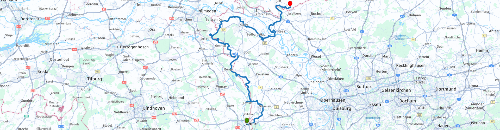
TTT 2019 05 Venlo Dinxperlo

This route was brought to you by:
RouteXpert Hans van de Ven (Mr.MRA)
Last edit: 10-04-2021
 Route Summary
 These TTT are touring through the Netherlands with the occasional trip to Belgium, Germany or even Luxembourg, which are driven 6 to 7 times a year. The 1st around March and the last around October. These TTTs have a starting point, a pause location and an end point. It is nice to discover what you have not seen in your own country and which nice roads you did not know before.
This TTT is from 2019, so the route may differ slightly from the original.
I have checked all route points and, where necessary, placed them on the road. Also, if necessary, I have further spaced the start point and end point of the route to avoid navigating directly to the end point and I added the POI files from the start and end point as well as possible pause location (s).
Finally, I made the route the same for TomTom, Garmin and MRA Navigation users.
Thanks to Promoter.
 Share this route


Animation

Verdict


Duration
4h 20m

Mode of travel
Car or motorcycle

Distance
169.67 km

Countries


 RouteXpert Review
 This Tank Bag Tour has many more surprises in store. You drive from De Maasduinen to the Rhine and then up again, onto the moraine at Groesbeek, to end up in the scenic landscape at Dinxperlo in the Achterhoek. The festivities start in Venlo. I hadn't been there for about thirty years and yes, then you quickly get lost. Boy, how things got over there. The core, however, remains upright: a fine collection of streets, the highlight of which is the Market and the old town hall. I also walk into the Limburgs Museum, where a retrospective of the local hero Evert Thielen, a man with a good eye for the female breast, is just being held. Hello, what a memmen!
The Mission Museum in Steyl, just below Venlo, is of a completely different nature. It really is such a museum where you get red ears of excitement. "You should see this ... and this ... and this!" I am referring in particular to the insect cabinet of Brother Berchmans, with his owl-head butterflies, hercules beetles and stick locusts. That it exists! And then you haven't been to the great room yet, with stuffed animals from all over the world. The collection is due to the missionaries of the Congregation of the Divine Word, who moved from all directions in Steyl.
From the monastery village - Steyl has three! - you cross the Maas with the ferry and there the free driving starts. It goes over the Brangk, hop onto the Legioendijk and steer, until behind Venlo, where a first hill unexpectedly presents itself, the Herungerberg. Above it appears that you are pretty much in Germany. It says "Frische Eier" and that's not how we say it. It is also immediately more spacious and quieter, with fewer cars and fewer houses. Friendly countryside.
The next stop is at the castle gardens of Arcen. I myself am not so fond of this kind of over-directed parks, where, so to speak, every tree has been thought about. After wandering around for an hour or so I surrender. Take those bonsai-pruned trees in the Eastern Water Garden. Yes, an eyebrow will rise. And when the rocky valley full of dry pines presents itself, Spain is not far away, or the United States. This is how this boy's eyes are really opened. The final conclusion: a tour through the castle gardens of Arcen is like a journey through faraway places, complete with a colony of pink flamingos and a screaming peacock in the tree.
Kasteel Arcen is located in De Maasduinen National Park, with river dunes that could develop on the eastern banks of the Maas due to the prevailing westerly winds. In motorcycle terms, that means better driving, over a rolling landscape, sometimes to the left, then to the right. I remember the Arcenerstraße, the Lingsforterweg, the Dorperheideweg, the Heerenvenweg: good steering and so we sail back into Germany, this time recognizable by the hunters' cabins and the many shutters.
Eventually you end up in Kevelaer, a place of pilgrimage, and connoisseurs know what that means: waving banners in the streets, bells and candles, lots of candles. The walls of the Kerzenkapelle are even completely blackened with smoke. There is also - that goes hand in hand in places of pilgrimage - a lot of restaurants, because all those pilgrims have to be fed and housed and of course they want to buy a souvenir for the home, even if it's just a boxer shorts or a nice hat. The dominant image in the city center: older couples who are happy sitting behind a cup of coffee. There comes a time when you no longer need it.
By far the most beautiful part of the route presents itself as you send via the Zwarteweg, Holleweg and Neutrale Weg to the dam at Groesbeek. Nobody can hear it, but I'm just screaming in excitement in my helmet: what a view! And it doesn't get any worse if you drive a little later on the Grafwegener Straβe, with the forests of the Reichswald rising on the right and a wide valley on the left for miles. The only thing that you have to watch out for here is that you don't run too fast from the weather forecast; 120 kilometers on the clock is perhaps a bit exaggerated.
The last stop in Germany before you finally return to the Netherlands in Kleve. Here too Promotor responds to the widely heard call for more diversity. Even though we know that there are motorcyclists who do not like modern art, you can visit the Museum Kurhaus Kleve here. The surroundings are fantastic, but I fear the worst inside, because I never understood anything about Joseph Beuys. See if it works. (Source: Promotor 06-2019).
Because I have driven large parts of this route myself, this route gets 4 stars.


 Links
Links  Usage
Usage Want to download this route?
You can download the route for free without MyRoute-app account. To do so, open the route and click 'save as'. Want to edit this route?
No problem, start by opening the route. Follow the tutorial and create your personal MyRoute-app account. After registration, your trial starts automatically.  Disclaimer
Use of this GPS route is at your own expense and risk. The route has been carefully composed and checked by a MyRoute-app accredited RouteXpert for use on TomTom, Garmin and MyRoute-app Navigation.
Changes may nevertheless have occurred due to changed circumstances, road diversions or seasonal closures. We therefore recommend checking each route before use.
Preferably use the route track in your navigation system. More information about the use of MyRoute-app can be found on the website under 'Community' or 'Academy'.

North Rhine-Westphalia
About this region
North Rhine-Westphalia (German: Nordrhein-Westfalen, pronounced [ˌnɔʁtʁaɪn vɛstˈfaːlən] (listen); Low Franconian: Noordrien-Wesfale; Low German: Noordrhien-Westfalen; Colognian: Noodrhing-Wäßßfaale), commonly shortened to NRW (German: [ɛnʔɛʁˈveː] (listen)), is a German state (Land) in Western Germany. With more than 17.9 million inhabitants, it is the most populous state of Germany. Covering an area of 34,084 square kilometres (13,160 sq mi), it is the fourth-largest German state by size. Apart from the city-states, it is also the most densely populated state in Germany.
North Rhine-Westphalia features 30 of the 81 German municipalities with over 100,000 inhabitants, including Cologne (over 1 million), the state capital Düsseldorf, Dortmund and Essen (all about 600,000 inhabitants) and other cities predominantly located in the Rhine-Ruhr metropolitan area, the largest urban area in Germany and the third-largest on the European continent. The location of the Rhine-Ruhr at the heart of the European Blue Banana makes it well connected to other major European cities and metropolitan areas like the Randstad, the Flemish Diamond and the Frankfurt Rhine-Main Region.
North Rhine-Westphalia was established in 1946 after World War II from the Prussian provinces of Westphalia and the northern part of Rhine Province (North Rhine), and the Free State of Lippe by the British military administration in Allied-occupied Germany and became a state of the Federal Republic of Germany in 1949. The city of Bonn served as the federal capital until the reunification of Germany in 1990 and as the seat of government until 1999.
Culturally, North Rhine-Westphalia is not a uniform area; there are significant differences, especially in traditional customs, between the Rhineland region on the one hand and the regions of Westphalia and Lippe on the other. The state has always been Germany's powerhouse with the largest economy among the German states by GDP figures.
Read more on Wikipedia
North Rhine-Westphalia features 30 of the 81 German municipalities with over 100,000 inhabitants, including Cologne (over 1 million), the state capital Düsseldorf, Dortmund and Essen (all about 600,000 inhabitants) and other cities predominantly located in the Rhine-Ruhr metropolitan area, the largest urban area in Germany and the third-largest on the European continent. The location of the Rhine-Ruhr at the heart of the European Blue Banana makes it well connected to other major European cities and metropolitan areas like the Randstad, the Flemish Diamond and the Frankfurt Rhine-Main Region.
North Rhine-Westphalia was established in 1946 after World War II from the Prussian provinces of Westphalia and the northern part of Rhine Province (North Rhine), and the Free State of Lippe by the British military administration in Allied-occupied Germany and became a state of the Federal Republic of Germany in 1949. The city of Bonn served as the federal capital until the reunification of Germany in 1990 and as the seat of government until 1999.
Culturally, North Rhine-Westphalia is not a uniform area; there are significant differences, especially in traditional customs, between the Rhineland region on the one hand and the regions of Westphalia and Lippe on the other. The state has always been Germany's powerhouse with the largest economy among the German states by GDP figures.
View region
 Statistics
  139
139Amount of RX reviews (North Rhine-Westphalia)
 78285
78285Amount of visitors (North Rhine-Westphalia)
 33684
33684Amount of downloads (North Rhine-Westphalia)
 Route Collections in this region
 The 10 most beautiful car and motorcycle routes in Limburg
Limburg, who thinks of Limburg, thinks of flan, coal mines, marl and the hill country. The coal mines have been closed for almost 40 years, the last load of coal was brought up from the Oranje-Nassau coal mine in Heerlen on 31 December and, as they say, South Limburg was transformed from Black to Green and unfortunately there is still little left. view of this period.
But not only pie, marl and coal in Limburg, but also a very beautiful province to tour by car or motorcycle and enjoy all the beauty that the province of Limburg has to offer. For this, the MyRoute app RouteXpert has put together a Top 10 of Car and Motorcycle routes for you.
All routes in this collection have been checked and made equal for TomTom, Garmin and MyRoute-app Navigation by a MyRoute-app RouteXpert.
If you think, I have a very nice route that should certainly not be missing from this collection, send it to:
email: routeexpert@myrouteapp.com
Subject: New Route for the Top 10 collection Province of Limburg composed by Hans van de Ven.
The route will then be reviewed and then added to the Top 10.
To make the Top 10 also the Top 10, 1 route will have to disappear from the Top 10, you can indicate this when submitting the new route.
Have fun with this collection and while driving one of these routes. Enjoy all the beauty that the Netherlands and in particular the province of Limburg has to offer. Click on “View route” to read the review of the chosen route.
I would like to hear your findings about the route(s).
View Route Collection
Top 5 Car and Motorcycle Routes in the Eifel
The Eifel is the eastern part of the medium plateau Eifel-Ardennes. It is located north of the Moselle and west of the Rhine. The largest part is in Germany, a small part is in Belgium, in the East Cantons. The German part of Eifel is located in the federal states of North Rhine-Westphalia and Rhineland-Palatinate. The highest point is the Hohe Acht with 747 meters.
Several chains can be distinguished in the Eifel:
The northernmost part is called the Nordeifel, which in Belgium connects to the High Fens;
To the east of this is the Ahrgebirge, this part is located north of the Ahr in the Ahrweiler district;
South of the Ahr is the Hohe Eifel (or Hocheifel), of which the Hohe Acht (747 m) is the highest point, and also the highest point in the entire Eifel region;
To the west, near the Belgian border, the hills are known as Schneifel, part of the wider Snow Eifel area with peaks reaching up to 698 metres;
South and east of the Hohe Eifel is the Volcano-Eifel, a volcanic area with many crater lakes (Maare).
The southern part of the Eifel is less high. The area is bisected by streams and rivers running southwards. These streams flow into the Moselle. The largest of these rivers is the Kyll; the hills around this river are known as the Kyllwald;
In the south, the Eifel ends in the Voreifel.
In the north of the Eifel there are some large reservoirs. The largest of these is the reservoir in the Roer that was created by the construction of the Roerdal dam.
The Nürburgring is also located in the Eifel, a well-known car circuit for Formula 1 races, among other things. Since 2004, part of the north of the Eifel has become the Eifel National Park. This National Park falls entirely within the German-Belgian nature park High Fens-Eifel. Another part of the Eifel falls within the South Eifel Nature Park.
Well-known throughout the Netherlands and Belgium by car and motorcyclists, so reason enough for the MyRoute app RouteXpert to compile a Top 5 of Car and Motorbike routes for you.
All routes in this collection have been checked and made equal for TomTom, Garmin and MyRoute-app Navigation by a MyRoute-app RouteXpert.
If you think, I have a very nice route that should certainly not be missing from this collection, send it to:
email: routeexpert@myrouteapp.com
Subject: New Route for the Top 5 collection Eifel composed by Hans van de Ven.
The route will then be reviewed and then added to the Top 5. To make the Top 5 also the Top 5, 1 route will have to disappear from the Top 5, you can indicate this when submitting the new route.
Have fun with this collection and while driving one of these routes. Enjoy all the beauty that the Eifel has to offer. Click on “View route” to read the review of the chosen route.
I would like to hear your findings about the route(s).
View Route Collection