TTT 2013 05 Etten Leur Bennekom

This route was brought to you by:
RouteXpert Hans van de Ven (Mr.MRA)
Last edit: 12-10-2019
 Route Summary
 The 173 ANWB Promoter TankTasTocht (TTT) were scanned by Henry ten Dam and signed by Leon Stolk in Mapsource and later placed as a Track in a .gpx file. These are made available through the MrGPS website with the approval of the ANWB Promoter so that everyone can enjoy them. The 1st TTT is from 1992, so the route may differ slightly from the original.
I have checked all route points and, where necessary, placed them neatly on the road. I have also, if necessary, set the starting point and end point of the route a little further apart to prevent navigation to the end point directly and added the POI files of the starting point and end point just like a possible stopping point.
Finally, I made the route the same for TomTom, Garmin and MyRoute-app Navigation users.
Thanks to Henry, Leon, MrGPS and Promoter.
 Share this route


Animation

Verdict


Duration
4h 26m

Mode of travel
Car or motorcycle

Distance
156.88 km

Countries

 RouteXpert Review
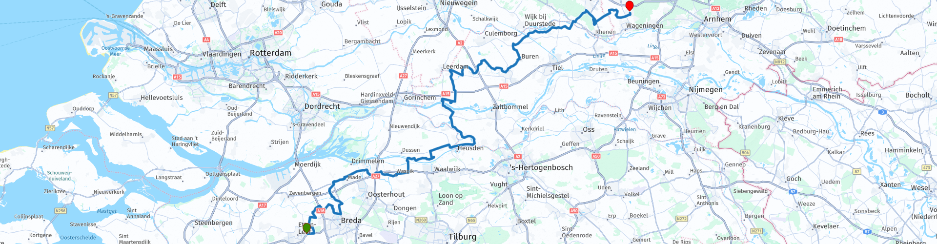
 After coffee it continues and we cross the mesh in the direction of Drongelen, until Ammerzoden we continue to follow the mesh and then we follow the dammed mesh to Aalst for a while. At Brakel we cross the Waal to Herwijnen and we have lunch in Buren. After lunch we drive via Maurik and we cross the Lower Rhine to Elst where we drive into the Prattenburgse Bos towards the end point in Bennekom.
Because I have not (yet) driven this route myself, this route gets 3 stars.
Route details:
rp 1 - McDonalds Etten-Leur
rp 17 - Eetcafé Hieriest in Waspik
rp 21 - Pontje Bergsche Maas: Skip route point used to prevent unnecessary detours on the Lord map
rp 27 - Viewpoint over the Waal
rp 29 - Pont Brakel-Herwijnen: Skip route point used, this to prevent unnecessary detours on the Lord map
rp 40 - Lunch stop at De Pannenkoekenbakker in Buren
rp 51 - Pontje Ingen-Elst: Skip route point used to prevent unnecessary detours on the Lord map
rp 59 - End point at Café de Keizer in Bennekom


 Links
Links  Usage
Usage Want to download this route?
You can download the route for free without MyRoute-app account. To do so, open the route and click 'save as'. Want to edit this route?
No problem, start by opening the route. Follow the tutorial and create your personal MyRoute-app account. After registration, your trial starts automatically.  Disclaimer
Use of this GPS route is at your own expense and risk. The route has been carefully composed and checked by a MyRoute-app accredited RouteXpert for use on TomTom, Garmin and MyRoute-app Navigation.
Changes may nevertheless have occurred due to changed circumstances, road diversions or seasonal closures. We therefore recommend checking each route before use.
Preferably use the route track in your navigation system. More information about the use of MyRoute-app can be found on the website under 'Community' or 'Academy'.