D04 Custer Wall

This route was brought to you by:
RouteXpert Hans van de Ven (Mr.MRA)
Last edit: 02-05-2021
 Route Summary
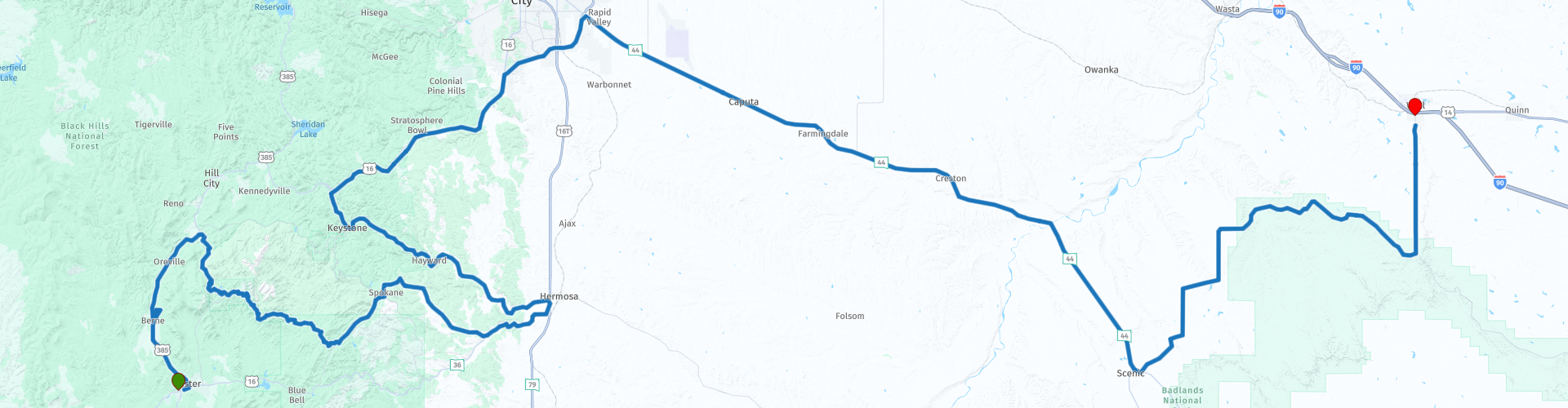
 The roads are good and the views are wide and beautiful, you should definitely do a longer stop at the Crazy Horse Memorial.
Starting point: Best Western Buffalo Ridge Inn
End point: Best Western Plains Motel
The route has been made the same for TomTom, Garmin and MyRoute-app Navigation users.
Thanks to Richard & Lisa for the information!
 Share this route


Animation

Verdict


Duration
5h 59m

Mode of travel
Car or motorcycle

Distance
252.16 km

Countries

 RouteXpert Review
 Far before you approach the town, the advertising signs are already along the I-90. Because you are confronted with this far in advance, you must visit this "city". The Wall Drugstore (this is where it all started) is the most famous store, with countless souvenirs and free ice water and stickers for every visitor. Popular bumper stickers are "Where the heck is Wall Drug?", "How many miles to Wall Drug?", And "Where in the world is Wall Drug?".
But before the time comes, first visit the Crazy Horse Memorial, this is a monument currently being carved into the granite of the Black Hills in the US state of South Dakota, in honor of the 19th-century Lakota leader Crazy Horse. When it is finished, it will portray Crazy Horse riding a galloping horse. (See website for details). After visiting the Crazy Horse Memorial, you can stop in Hermosa to eat and drink before heading back into the Black Hills. After the Black Hills and refueling and shopping in Rapid City, this is the last place you can refuel before the end point. It is also nice to stop in the Badlands National Park or along the unpaved Sage Creek Road for something to drink and eat, perhaps you will get a visit from a Bison.
After Sage Creek Road, turn left to drive a straight line to Wall where you can refuel the engine just in front of the hotel and go shopping at the Wall Drug Store after check-in. You must have been there.
In this 4-star route you will drive along beautiful good roads, with a nice stop at the Crazy Horse Memorial and of course shopping in Wall.
History:
The Badlands were created as a result of two geological processes: deposition and erosion. Various layers of sedimentary rock have been created by deposits of different materials such as sand, salt and clay. From the Cretaceous period (75 to 67 million years ago) to the oligocene (34 to 26 million years ago), the area has been a sea, tropical land and a wooded land with rivers. Each landscape had its own characteristics, which are now reflected in the different colors of rock layers. The light-colored Sharps Formation, which now forms the rough peaks and canyons, is the youngest layer of rock and was formed 28 to 30 million years ago by wind and water. The climate was dry and cool at the time and volcanic eruptions covered the country with ash. In the lower areas, the rivers continued to deposit rocks from the Black Hills. The depositing of material stopped 500,000 years ago, when the Cheyenne River added the streams from the mountains. The water no longer reached the Badlands, resulting in erosion. New rivers found their way through the rock layers and carved all possible forms in the Badlandsvlakte. Because the area drops about 2.5 centimeters each year, it is expected that in 500,000 years not much will be left of the Badlands.
Various objects and remains from the ecocene and oligocene have been found under the many layers of soil. During the late ecocene and early oligocene (37 to 28 million years ago), the area was more fertile, damp and warmer than today. During large floods many mammals such as camels, three-toe horses, oreodons (herbivores the size of sheep), rhinos and rabbits were killed. As a result, their remains were buried under river sediment. The fossils of marine animals found are even older. In the Pierre Shale and Fox Hills Formations, fossils of fish, marine reptiles and turtles from 75 to 67 million years old have been found. Human utensils and bones that surfaced are no more than 11,000 years old.
The Lakota Indians, who inhabited the area before the European colonization, made the first finds. Then came the fur-hunters, who took away found objects. The first article about the finds was published in the mid-nineteenth century. This made fossil hunting in the Badlands incredibly popular.


 Links
Links  Usage
Usage Want to download this route?
You can download the route for free without MyRoute-app account. To do so, open the route and click 'save as'. Want to edit this route?
No problem, start by opening the route. Follow the tutorial and create your personal MyRoute-app account. After registration, your trial starts automatically.  Disclaimer
Use of this GPS route is at your own expense and risk. The route has been carefully composed and checked by a MyRoute-app accredited RouteXpert for use on TomTom, Garmin and MyRoute-app Navigation.
Changes may nevertheless have occurred due to changed circumstances, road diversions or seasonal closures. We therefore recommend checking each route before use.
Preferably use the route track in your navigation system. More information about the use of MyRoute-app can be found on the website under 'Community' or 'Academy'.

South Dakota
About this region
South Dakota (Sioux: Dakȟóta itókaga) is a U.S. state in the upper Midwestern United States. It is named after the Lakota and Dakota Sioux Native American tribes, who comprise a large portion of the population with nine reservations currently in the state and have historically dominated the territory. South Dakota is the seventeenth largest by area, but the 5th least populous, and the 5th least densely populated of the 50 United States. As the southern part of the former Dakota Territory, South Dakota became a state on November 2, 1889, simultaneously with North Dakota. They are the 39th and 40th states admitted to the union; President Benjamin Harrison shuffled the statehood papers before signing them so that no one could tell which became a state first. Pierre is the state capital, and Sioux Falls, with a population of about 187,200, is South Dakota's largest city.
South Dakota is bordered by the states of North Dakota (to the north), Minnesota (to the east), Iowa (to the southeast), Nebraska (to the south), Wyoming (to the west), and Montana (to the northwest). The state is bisected by the Missouri River, dividing South Dakota into two geographically and socially distinct halves, known to residents as "East River" and "West River".Eastern South Dakota is home to most of the state's population, and the area's fertile soil is used to grow a variety of crops. West of the Missouri River, ranching is the predominant agricultural activity, and the economy is more dependent on tourism and defense spending. Most of the Native American reservations are in West River. The Black Hills, a group of low pine-covered mountains sacred to the Sioux, is in the southwest part of the state. Mount Rushmore, a major tourist destination, is there. South Dakota has a temperate continental climate, with four distinct seasons and precipitation ranging from moderate in the east to semi-arid in the west. The state's ecology features species typical of a North American grassland biome.
Humans have inhabited the area for several millennia, with the Sioux becoming dominant by the early 19th century. In the late 19th century, European-American settlement intensified after a gold rush in the Black Hills and the construction of railroads from the east. Encroaching miners and settlers triggered a number of Indian wars, ending with the Wounded Knee Massacre in 1890. Key events in the 20th century included the Dust Bowl and Great Depression, increased federal spending during the 1940s and 1950s for agriculture and defense, and an industrialization of agriculture that has reduced family farming.
While several Democrats have represented South Dakota for multiple terms in both chambers of Congress, the state government is largely controlled by the Republican Party, whose nominees have carried South Dakota in each of the last 13 presidential elections. Historically dominated by an agricultural economy and a rural lifestyle, South Dakota has recently sought to diversify its economy in areas to attract and retain residents. South Dakota's history and rural character still influence strongly the state's culture.
Read more on Wikipedia
South Dakota is bordered by the states of North Dakota (to the north), Minnesota (to the east), Iowa (to the southeast), Nebraska (to the south), Wyoming (to the west), and Montana (to the northwest). The state is bisected by the Missouri River, dividing South Dakota into two geographically and socially distinct halves, known to residents as "East River" and "West River".Eastern South Dakota is home to most of the state's population, and the area's fertile soil is used to grow a variety of crops. West of the Missouri River, ranching is the predominant agricultural activity, and the economy is more dependent on tourism and defense spending. Most of the Native American reservations are in West River. The Black Hills, a group of low pine-covered mountains sacred to the Sioux, is in the southwest part of the state. Mount Rushmore, a major tourist destination, is there. South Dakota has a temperate continental climate, with four distinct seasons and precipitation ranging from moderate in the east to semi-arid in the west. The state's ecology features species typical of a North American grassland biome.
Humans have inhabited the area for several millennia, with the Sioux becoming dominant by the early 19th century. In the late 19th century, European-American settlement intensified after a gold rush in the Black Hills and the construction of railroads from the east. Encroaching miners and settlers triggered a number of Indian wars, ending with the Wounded Knee Massacre in 1890. Key events in the 20th century included the Dust Bowl and Great Depression, increased federal spending during the 1940s and 1950s for agriculture and defense, and an industrialization of agriculture that has reduced family farming.
While several Democrats have represented South Dakota for multiple terms in both chambers of Congress, the state government is largely controlled by the Republican Party, whose nominees have carried South Dakota in each of the last 13 presidential elections. Historically dominated by an agricultural economy and a rural lifestyle, South Dakota has recently sought to diversify its economy in areas to attract and retain residents. South Dakota's history and rural character still influence strongly the state's culture.
View region
 Statistics
  10
10Amount of RX reviews (South Dakota)
 15386
15386Amount of visitors (South Dakota)
 155
155Amount of downloads (South Dakota)
 Route Collections in this region
 Top car and motorcycle tour through the Midwest of the USA
By car or motorcycle through the Midwest of America is a journey that you do not just make, so it is not a 13-day drive and then back home. No, book a stay of several days in Denver, Cheyenne, Rapid City (In August the Sturgis Bike Ralley, stay there for a day or 4), Yellowstone National Park, Estes Park and again Denver to also visit several places of interest in these cities, so that this tour becomes an unforgettable tour that you can remember with pleasure.
Do not forget to arrange and pack the following items:
*This is only a summary and completely personal and may differ per person.
Take out travel insurance, +31 for numbers in GSM, (partially) take out gas, Health insurance coverage at destination?, Switch off electrical appliances, Lighting (time clock), Check passport validity, Antenna from radio/TV due to lightning, Residence address for those left behind, Remote control house alarm, Book Smart Parking.
Hand luggage:
Liquids in packaging of max. 100 ml, Liquids in hand luggage in transparent plastic bag.
For on the road:
Candy, Book, Earplugs, Country and road map(s), Directions, Maps in your navigation system
Money & Securities:
Bank card / giro card, Credit card (think pin code), Cash, Calculator for Internet banking, Medical insurance card, Travel insurance card.
Travel documents:
Passport, (International) Driver's License, Ticket(s), Reservation Tickets, Hotel Vouchers, Arrival/Departure Time, Check-in & Check-out Times, Valid Visa (ESTA), Travel Guide.
Clothing:
Underwear, Belt, Shirts/ T-shirts, Shorts, Long pants, Shoes, Socks, Swim trunks, Towel, Slippers.
Personal stuff:
Watch, House Keys, Wallet, Sunglasses.
Toiletries:
Deodorant, Shower gel / Soap, Comb / brush, Shaving equipment, Shampoo, Toothbrush, Toothpaste, Sanitary pads
Health & Medicine:
Own medicines, Insect repellent, Cold sore ointment, Ointment for insect bites, Sunscreen, Norit, Paracetamol, Suction cup for insect bites, First aid bag.
Miscellaneous:
Travel bag / waist bag, Leatherman (= checked luggage), Pen or pencil, Headlamp, Lighter, Tools & Electronics, Mobile phone & charger, Photo/video camera & charger, Memory card(s), World plug / adapter, Ipod & charger, Adapter cable Ipod, Headphones, iPad & charger, Navigation & charger/plug, Plug socket, Fuelpack battery.
Engine (accessories):
Helmet, Motorcycle clothing, Motorcycle boots, Chain lock / disc brake lock, Gloves, Bandana, Inner bags (plastic shopping bag), Insulation bag, Tension straps, Tie wraps, Rain suit, Rainaway.
Addresses:
Address list, Embassy telephone number, Telephone number to block (bank) card(s), Telephone number (airline tickets).
View Route Collection
The 10 most downloaded routes in the USA from RouteXpert Hans van de Ven
Hello and welcome to this collection of the Top 10 MyRoute app downloaded routes in USA.
There will be a great new event to be announced soon, where all these routes can be driven.
Download them all now and place them in a new "Top 10" folder, so that you always have them at hand.
If you are going to drive one of these routes in the meantime, track them with the MRA Mobile App or with MRA Navigation. Take some photos (moments) along the way as these will come in handy.
Create a travelogue of your Top 10 driven routes and add the recorded track to it.
There will also be some great prizes on offer, so keep an eye on the MRA-RouteXperts page and your mail.
The 10 routes are:
1. D13 Estes Park Denver
2. D03 Chadron Custer
3. D01 Pigeon Forge round trip through the Smokey Mountains
4. D08 Kalispell Sandpoint
5. D10 Colville Wenatchee
6. D09 Sandpoint Colville
7. D04 Custer Wall
8. D11 Wenatchee Seattle
9. D08 Cody Yellowstone NP
10.R13 San Francisco Monterey
View Route Collection