TTT 2015 05 Doetinchem Zutphen

This route was brought to you by:
RouteXpert Hans van de Ven (Mr.MRA)
Last edit: 27-12-2019
 Route Summary
 The 173 ANWB Promoter TankTasTocht (TTT) were scanned by Henry ten Dam and signed by Leon Stolk in Mapsource and later placed as a Track in a .gpx file. These have been made available through the MrGPS website with the approval of the ANWB Promoter so that everyone can enjoy it. The 1st TTT is from 1992, so the route may differ slightly from the original.
I have checked all route points and, where necessary, placed them neatly on the road. Also, if necessary, I have further spaced the start point and end point of the route to avoid navigating directly to the end point and I added the POI files from the start and end point just like a possible stopping point.
Finally, I made the route the same for TomTom, Garmin and MyRoute-app Navigation users.
Thanks to Henry, Leon, MrGPS and Promoter.
 Share this route


Animation

Verdict


Duration
3h 41m

Mode of travel
Car or motorcycle

Distance
123.50 km

Countries


 RouteXpert Review
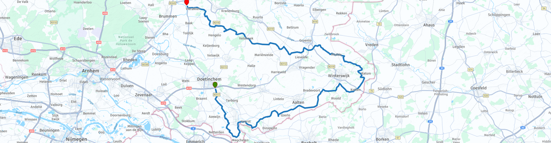
 Quite soon after the start you cross the old IJssel for the 1st time, you do this again in Gendringen. The Oude IJssel is a tributary of the IJssel river. The Oude IJssel starts in Germany under the name Issel and then runs through the municipalities of Oude IJsselstreek, Doetinchem and Bronckhorst, after which it flows into the IJssel near Doesburg. In Lower Saxon, the river is called the Olde Iessel or simply Iessel.
A little further, you are on your way to Aalten, just before Dinxperlo you cross the Aa strang, this is a German-Dutch river. The Aa-strang, which in Germany is called the Bocholter Aa, is formed in the surroundings of Velen by the merging of the streams: Thesingbach, Weißer Vennbach and Schwarzer Bach. The river runs via Borken and Rhede to Bocholt and further west.
After Aalten you set course for the Bekendelle or Bekkendelle, this is a nature reserve south of Winterswijk. It is part of the Winterswijk National Landscape designated as such in 2005 and was designated as a Natura 2000 site in 2010. Bekendelle is an old broadleaf deciduous forest through which the Upper Slinge meanders. We drive on and stop in Kotten at the Celtic Coffee House to drink coffee. I think they also have tea there!
After the stop we continue and stop for a photo at the quarry in Winterswijk, this is a open-cast mine where mainly limestone is extracted. The quarry has been in use since 1932, specifically by NV Winterswijkse Steen- en Kalkgroeve, now part of Sibelco. Of the three quarries, one is still in use. Then we make another stop in Meddo, at the famous Motorhotel.
After Meddo we pass the Groenlo Slinge, this is a lowland stream that rises behind Winterswijk. As the name implies, the stream runs past Groenlo and flows into the Berkel between Lochem and Borculo. The Groenlo Slinge has not always had the same course. For example, it was a meandering river that in the old days was called Slinck or Slingen, and ran through the moat of the fortified city of Groenlo. Later he moved to the north of Groenlo and in the 20th century he was largely channeled for more efficient drainage.
Just before Veldhoek you pass the Veengoot for the first time, this is a small river situated in the Dutch region of the Achterhoek. The Veengoot has its origins just south of Lichtenvoorde. It flows globally in a northwestern direction. In addition, he passes the places Harreveld, Mariënvelde, Veldhoek and Vorden at a short distance.
Via Vorden, where you pass the Veengoot for the 2nd time, you drive via Vierakker to the end point in Zutphen.
Because I have driven large parts of this route myself, this route gets 4 stars.
Route details:
rp 26 - Celtic Coffee House
rp 27 - Winterswijk quarry
rp 33 - Motorhotel Meddo


 Links
Links  Usage
Usage Want to download this route?
You can download the route for free without MyRoute-app account. To do so, open the route and click 'save as'. Want to edit this route?
No problem, start by opening the route. Follow the tutorial and create your personal MyRoute-app account. After registration, your trial starts automatically.  Disclaimer
Use of this GPS route is at your own expense and risk. The route has been carefully composed and checked by a MyRoute-app accredited RouteXpert for use on TomTom, Garmin and MyRoute-app Navigation.
Changes may nevertheless have occurred due to changed circumstances, road diversions or seasonal closures. We therefore recommend checking each route before use.
Preferably use the route track in your navigation system. More information about the use of MyRoute-app can be found on the website under 'Community' or 'Academy'.

Gelderland
About this region
Gelderland (Dutch: [ˈɣɛldərlɑnt] (listen)), also known as Guelders () in English, is a province of the Netherlands, occupying the centre-east of the country. With a total area of 5,136 km2 (1,983 sq mi) of which 173 km2 (67 sq mi) is water, it is the largest province of the Netherlands. Gelderland shares borders with six other provinces (Flevoland, Limburg, North Brabant, Overijssel, South Holland and Utrecht) and the German state of North Rhine-Westphalia.
The capital is Arnhem (pop. 159,265); however, Nijmegen (pop. 176,731) and Apeldoorn (pop. 162,445) are both larger municipalities. Other major regional centres in Gelderland are Ede, Doetinchem, Zutphen, Harderwijk, Tiel, Wageningen, Zevenaar, and Winterswijk. Gelderland had a population of 2,084,478 as of November 2019.
Read more on Wikipedia
The capital is Arnhem (pop. 159,265); however, Nijmegen (pop. 176,731) and Apeldoorn (pop. 162,445) are both larger municipalities. Other major regional centres in Gelderland are Ede, Doetinchem, Zutphen, Harderwijk, Tiel, Wageningen, Zevenaar, and Winterswijk. Gelderland had a population of 2,084,478 as of November 2019.
View region
 Statistics
  135
135Amount of RX reviews (Gelderland)
 59015
59015Amount of visitors (Gelderland)
 33972
33972Amount of downloads (Gelderland)
 Route Collections in this region
 The 10 most beautiful car and motorcycle routes in North Brabant
Brabant, Brabant conviviality, bon vivants and who does not know the song by Guus Meeuwis about Brabant? "And then I think of Brabant, because there is still light burning there" and that is true, because the City of Light is in Brabant, in Eindhoven that is, but Eindhoven is also known as the match city of the Netherlands. The annual light festival (GLOW) in Eindhoven shows breathtaking lighting techniques, something you must see once.
But not only light, matches and Brabant cosiness in Brabant, but also a very beautiful province to tour by car or motorcycle and enjoy all the beauty that the province of Brabant has to offer. For this, the MyRoute app RouteXpert has put together a Top 10 of Car and Motorcycle routes for you.
All routes in this collection have been checked and made equal for TomTom, Garmin and MyRoute-app Navigation by a MyRoute-app RouteXpert.
If you think, I have a very nice route that should certainly not be missing from this collection, send it to:
email: routeexpert@myrouteapp.com
Subject: New Route for the Top 10 collection Province of Brabant composed by Hans van de Ven.
The route will then be reviewed and then added to the Top 10.
To make the Top 10 also the Top 10, 1 route will have to disappear from the Top 10, you can indicate this when submitting the new route.
Have fun with this collection and while driving one of these routes. Enjoy all the beauty that the Netherlands and in particular the province of Brabant has to offer. Click on “View route” to read the review of the chosen route.
I would like to hear your findings about the route(s).
View Route Collection
The 10 most beautiful car and motorcycle routes in Limburg
Limburg, who thinks of Limburg, thinks of flan, coal mines, marl and the hill country. The coal mines have been closed for almost 40 years, the last load of coal was brought up from the Oranje-Nassau coal mine in Heerlen on 31 December and, as they say, South Limburg was transformed from Black to Green and unfortunately there is still little left. view of this period.
But not only pie, marl and coal in Limburg, but also a very beautiful province to tour by car or motorcycle and enjoy all the beauty that the province of Limburg has to offer. For this, the MyRoute app RouteXpert has put together a Top 10 of Car and Motorcycle routes for you.
All routes in this collection have been checked and made equal for TomTom, Garmin and MyRoute-app Navigation by a MyRoute-app RouteXpert.
If you think, I have a very nice route that should certainly not be missing from this collection, send it to:
email: routeexpert@myrouteapp.com
Subject: New Route for the Top 10 collection Province of Limburg composed by Hans van de Ven.
The route will then be reviewed and then added to the Top 10.
To make the Top 10 also the Top 10, 1 route will have to disappear from the Top 10, you can indicate this when submitting the new route.
Have fun with this collection and while driving one of these routes. Enjoy all the beauty that the Netherlands and in particular the province of Limburg has to offer. Click on “View route” to read the review of the chosen route.
I would like to hear your findings about the route(s).
View Route Collection