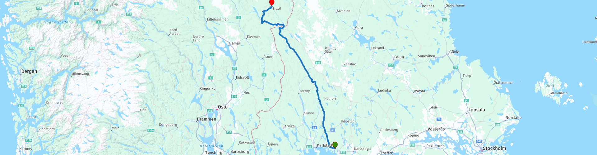
R04 Olme Trysil

This route was brought to you by:
RouteXpert Hans van de Ven (Mr.MRA)
Last edit: 11-01-2020
 Route Summary
 The views are good, the roads are better and the curves are best!
Starting point: Bo hos Nancy i Ölme.
End point: Trysil Hotell
The route has been made the same for TomTom, Garmin and MyRoute-app Navigation users.
 Share this route


Animation

Verdict


Duration
4h 57m

Mode of travel
Car or motorcycle

Distance
322.54 km

Countries


 RouteXpert Review
 Finnskogen is a vast forest area on the border of Norway and Sweden. It includes the eastern part of the Norwegian fylke Hedmark and the adjacent northwestern part of the Swedish landscape Värmland.
Trysil is a municipality in the Norwegian province of Innlandet in the middle of Norway. Trysil is a vast municipality, wooded and sparsely populated. In terms of surface area, it is the second largest municipality in Hedmark after Rendalen. Trysil is close to the Swedish border, about two and a half hours outside of Oslo. In Trysil you will find the largest winter sports area in Norway. With its dense forests, wild river and inviting mountains, Trysil is also an ideal base for summer activities such as fishing, white water rafting or hiking. There is also much to experience on two wheels, Trysil Bike Arena offers 100 kilometers of nature trails, in addition to more than 10 kilometers of carefully laid gravel paths.
Trysil is actually one large ski area. The three mountain flanks are interconnected with lifts and slopes. The highest point is 1132 meters, and from the top you can see many kilometers in all directions.
There are two stops included in the route, but of course you can stop on the way at one of the many picnic areas to have something to eat and drink. You can buy things for this on the way at a supermarket. After 1h30M you are in Ekshärad, there is opposite Café Bistro Moccacino, where the coffee break is planned, an ICA Indian supermarket, buy your food and drink for that if you want to have a picnic on the way.
After +/- 128 KM, at route point 7, you can choose between driving gravel occasionally or on the asphalted road.
If you do not want to drive over gravel, turn right at route point 7, and continue to follow the 62 for 57 KM until you reach the town of Sysslebäck (route point 14). You then skip the route points 8 to 13!
During the route you will always be close to the river Klarälven, this is the longest river in Scandinavia, with a length of 460 kilometers. The Swedish part is also the longest river in Sweden. In Norway the river is called Femundselva and Trysilelva.
In this 4-star route you mainly drive on good roads, you will regularly stop to take some pictures, and the choice to ride over gravel again.
General information:
Sweden is a beautiful country. You will find nice cities, but also impressive nature reserves. Check the weather forecast. In Sweden it can be very hot, but it can also become very cold, so that you can bring the right clothes and other aids. Furthermore, it is advisable to book your accommodations in Sweden in advance. Sweden is a wonderful destination for a beautiful motorcycle vacation. As the largest country in Scandinavia you can go on extensive tours in a unique environment. Forests, lakes, nature parks and agricultural areas largely determine the landscape. Around the Swedish-Norwegian border lies the Scandinavian Highland, where the mountains rise locally to 2100 meters. The most important cities are Stockholm, Gothenburg and Malmö. And if you cannot find a motor camping site or motor hotel, then it is allowed on the basis of the so-called Allemansrätten or everyone's right to camp freely in nature. As long as you take nothing with you and leave no mess behind, you can stay with your tent for a maximum of 24 hours in one location.
South Sweden also has the most motorcycle campsites, motorcycle hotels and other motorcycle-friendly accommodations. This part also contains the 5650 square kilometers of Vänermeer and the smaller Vänermeer.


 Links
Links  Usage
Usage Want to download this route?
You can download the route for free without MyRoute-app account. To do so, open the route and click 'save as'. Want to edit this route?
No problem, start by opening the route. Follow the tutorial and create your personal MyRoute-app account. After registration, your trial starts automatically.  Disclaimer
Use of this GPS route is at your own expense and risk. The route has been carefully composed and checked by a MyRoute-app accredited RouteXpert for use on TomTom, Garmin and MyRoute-app Navigation.
Changes may nevertheless have occurred due to changed circumstances, road diversions or seasonal closures. We therefore recommend checking each route before use.
Preferably use the route track in your navigation system. More information about the use of MyRoute-app can be found on the website under 'Community' or 'Academy'.

Hedmark
About this region
Hedmark ([ˈhêːdmɑrk] (listen)) was a county in Norway before 1 January 2020, bordering Trøndelag to the north, Oppland to the west, Akershus to the south, and Sweden to the east. The county administration is in Hamar.
Hedmark and Oppland counties were merged into Innlandet county on 1 January 2020, when Norway's former 19 counties became 10 bigger counties / regions
Hedmark made up the northeastern part of Østlandet, the southeastern part of the country. It had a long border with Sweden to the east (Dalarna County and Värmland County). The largest lakes were Femunden and Mjøsa, the largest lake in Norway. Parts of Glomma, Norway's longest river, flowed through Hedmark. Geographically,
Hedmark was traditionally divided into: Hedemarken (east of the lake Mjøsa), Østerdalen ("East Valley" north of the town Elverum), and Solør / Glåmdalen (south of Elverum) and Odal in the very south. Hedmark and Oppland were the only Norwegian counties with no coastline. Hedmark also hosted some events of the 1994 Winter Olympic Games.
Hamar, Kongsvinger, Elverum and Tynset were cities in the county. Hedmark was one of the less urbanized areas in Norway; about half of the inhabitants lived on rural land. The population was mainly concentrated in the rich agricultural district adjoining Mjøsa to the southeast. The county's extensive forests supplied much of Norway's timber; at one time, logs were floated down Glomma to the coast but are now transported by truck and train.
The Hedmark municipality of Engerdal had the distinction of marking the current southernmost border in Norway of Sápmi, the traditional region of the Sami people.
The county was divided into three traditional districts. Those were Hedmarken, Østerdalen and Solør (with Odalen and Vinger).
Hedmark was originally a part of the large Akershus amt, but in 1757 Oplandenes amt was separated from it. Some years later, in 1781, this was divided into Kristians amt (now Oppland) and Hedemarkens amt. Until 1919, the county was called Hedemarkens amt.
Read more on Wikipedia
Hedmark and Oppland counties were merged into Innlandet county on 1 January 2020, when Norway's former 19 counties became 10 bigger counties / regions
Hedmark made up the northeastern part of Østlandet, the southeastern part of the country. It had a long border with Sweden to the east (Dalarna County and Värmland County). The largest lakes were Femunden and Mjøsa, the largest lake in Norway. Parts of Glomma, Norway's longest river, flowed through Hedmark. Geographically,
Hedmark was traditionally divided into: Hedemarken (east of the lake Mjøsa), Østerdalen ("East Valley" north of the town Elverum), and Solør / Glåmdalen (south of Elverum) and Odal in the very south. Hedmark and Oppland were the only Norwegian counties with no coastline. Hedmark also hosted some events of the 1994 Winter Olympic Games.
Hamar, Kongsvinger, Elverum and Tynset were cities in the county. Hedmark was one of the less urbanized areas in Norway; about half of the inhabitants lived on rural land. The population was mainly concentrated in the rich agricultural district adjoining Mjøsa to the southeast. The county's extensive forests supplied much of Norway's timber; at one time, logs were floated down Glomma to the coast but are now transported by truck and train.
The Hedmark municipality of Engerdal had the distinction of marking the current southernmost border in Norway of Sápmi, the traditional region of the Sami people.
The county was divided into three traditional districts. Those were Hedmarken, Østerdalen and Solør (with Odalen and Vinger).
Hedmark was originally a part of the large Akershus amt, but in 1757 Oplandenes amt was separated from it. Some years later, in 1781, this was divided into Kristians amt (now Oppland) and Hedemarkens amt. Until 1919, the county was called Hedemarkens amt.
View region
 Statistics
  8
8Amount of RX reviews (Hedmark)
 25476
25476Amount of visitors (Hedmark)
 703
703Amount of downloads (Hedmark)
 Route Collections in this region
 Top Car and Motorcycle tour through Sweden and Norway
Sweden and Norway are beautiful countries. You will find nice cities, but also impressive nature reserves. This versatility makes Sweden & Norway the perfect countries for an impressive motorcycle holiday.
In this collection 14 beautiful routes through Sweden & Norway.
Good preparation is half the battle, so read the tips below carefully.
1. Check the weather forecast. It can be very hot in Sweden & Norway, but it can also get very cold. Always check the weather forecast before you go, so that you can pack the right clothes.
2. Decide in advance which route or routes you want to follow. This way you don't drive around like a headless chicken and you can make the most of your days off in these beautiful countries.
3. Familiarize yourself with the traffic rules. In Sweden & Norway, in some situations, slightly different rules apply than in the Netherlands. By immersing yourself in the traffic rules, you prevent (unknowingly) committing a traffic violation and/or putting yourself in a dangerous situation.
It is also wise to book the accommodations in advance. It might be more fun to drive through these countries on spec, but you don't want to drive around endlessly to find a place to sleep. If you go to Sweden or Norway during the high season, the chance that you will have to look for a place to sleep is greatest. It is also possible to camp during your motorcycle trip, but find out in advance where this is and is not allowed. You are not allowed to pitch your tent everywhere.
As the largest country in Scandinavia, you can enjoy extensive tours in a unique environment. Forests, lakes, nature parks and agricultural areas largely determine the landscape, which also consists of flat areas and rolling hills. Around the Swedish-Norwegian border is the Scandinavian Highlands, where the mountains rise locally to 2100 meters.
Norway is known for its amazing natural beauty. Fjords that go into the country tens of kilometers deep, snow-covered plateaus, sharp mountain peaks and vast forests. In this sparsely populated country, most people live in the cities, of which the capital Oslo is the largest.
Tolls have to be paid on a large number of roads in Norway. If you approach a toll road, you can continue without stopping. With cameras above the road, the license plate of the vehicle is scanned, not the registration number of the trailer or caravan. It takes quite some time to process the photos.
The bill is then sent home within four to six months by Euro Parking Collection (EPC) in London.
Mandatory on the motorcycle: Safety vest - A motorcyclist must bring at least one safety vest. In the event of a breakdown or accident, the driver is obliged to wear a safety vest. The ANWB advises motorcyclists to also bring a safety vest for a possible passenger.
Advice: First aid kit, motorcyclists are advised to bring a first aid kit.
View Route Collection
6500 kilometers through Scandinavia with the highlights of the Lofoten and the North Cape
The Arctic Challenge Tour, on which this 26-part tour is partly based, is not a speed race. It's a tour. It comes down to agility, good navigation and anticipation. The participants are obliged to adhere to the speed limit of the country concerned. The participants must find the ideal route with the shortest possible distance by complying 100% with the locally applicable traffic rules. Of course, also take maximum speeds into account. The organization checks for violations of the speed limit. In case of gross or repeated exceeding of the maximum speed, disqualification for the relevant stage and for the final classification will follow. Control of the route and speeds is done by means of a track and trace system. This equipment is installed in every vehicle. You can then follow each team accurately in the Back Office. Those staying at home, interested parties and participants can also see the performances of the teams, because you can be followed live via the Internet. The Back Office takes action when a team gets into trouble. (source: website The Arctic Challenge)
That's quite a luxury, having a back office behind you that keeps an eye on you. Most of us will not have that and are on our own or the fellow traveler(s). The only agreement you have with the participants is that you also have to abide by the rules. Fortunately, you don't have to complete this tour in 9 days, like the participants, but you can take it a little longer.
The highlight of the Arctic Challenge in 2020 was the Lofoten, an island group northwest of Norway. The Lofoten archipelago is located in the middle of the wild Norwegian Sea, well above the Arctic Circle. This special region offers a beautiful landscape with imposing mountains, deep fjords and long, wild sandy beaches where the sound of the seabird colonies can always be heard.
The archipelago is best known for its rich fishing tradition. The Lofoten makes a prosperous impression despite their isolated location. The entire economy revolves above all around fishing. The image of the Lofoten is mainly dominated by wooden racks with cod, which hangs to dry. Lofoten fishing has been a household name for centuries. In the middle of winter, the ships set out to catch the fish in just a few months. The rich fishing grounds are due to the North Atlantic Warm Gulf Stream around the islands, in which the fish have their spawning grounds. Oil drilling is not permitted around Lofoten and the cod spawning grounds there.
The next destination for the participants was Sirkka, also known as Levi, a winter sports resort in Finnish Lapland. They stayed there for a few days to go ice-karting and to enjoy the snow by going on a snowmobile or skiing trip. This tour also takes you to Sirkka, but instead of staying there for a few days, you have the option to continue to the North Cape, the second highlight of this trip.
Imagine a place in the far north, where the Atlantic Ocean meets the icy waters of the Arctic Ocean. This place is the North Cape in Western Finnmark in Northern Norway. From here, only the archipelago of Spitsbergen lies between you and the North Pole and the sun shines for 2.5 months at a time; from mid-May to the end of July. Many visitors admire the midnight sun or the sunset over the Barents Sea from the North Cape plateau.
With each route you will find a review with a description of the route, where you pass and what to see along the way. It is also briefly described how the participants in the Arctic Challenge in 2020 had to drive it anyway, from which point to which point. Along the way, markings (route points) have been included that indicate the end points of the stages that the participants had to complete. As mentioned, they covered the distance in 9 days, stages of more than 1000 kilometers were no exception.
Each route ends at a hotel. It is of course not an obligation to use these hotels, you can always find another place to stay in the area, that decision is up to you. My experience, however, is that they are all simple but good hotels for a very reasonable price. They are known and can be booked at booking.com.
The routes of these collections:
R01 - Puttgarden to Angelholm, 280km
R02 - Angelholm to Alingsas, 281km
R03 - Alingsas to Mysen, 261km
R04 - Mysen to Rena, 312km
R05 - Rena to Orkanger, 306km
R06 - Orkanger to Grong, 292km
R07 - Grong to Mo i Rana, 290km
R08 - Mo i Rana to Bodo, 231km
R09 - Roundtour Bodo to Lofoten part 1, 314km
R10 - Roundtour Bodo to Lofoten part 2, 250km
R11 - Roundtour Bodo to Lofoten part 3, 291km
R12 - Bodo to Arjeplog, 295km
R13 - Arjeplog to Jokkmokk, 244km
R14 - Jokkmokk to Pajala, 239km
R15 - Roundtour Sirkka to North Cape part 1, 257km
R16 - Roundtour Sirkka to North Cape part 2, 300km
R17 - Roundtour Sirkka to North Cape part 3, 244km
R18 - Roundtour Sirkka to North Cape part 4, 275km
R19 - Roundtour Sirkka to North Cape part 5, 332km
R20 - Sirkka to Kemi, 299km
R21 - Kemi to Ylivieska, 251km
R22 - Ylivieska to Jalasjarvi, 236km
R23 - Jalasjarvi to Turku, 279km
R24 - Stockholm to Askersund, 271km
R25 - Askersund to Varnamo, 224
R26 - Varnamo to Trelleborg, 259km
Have fun driving these routes!
View Route Collection