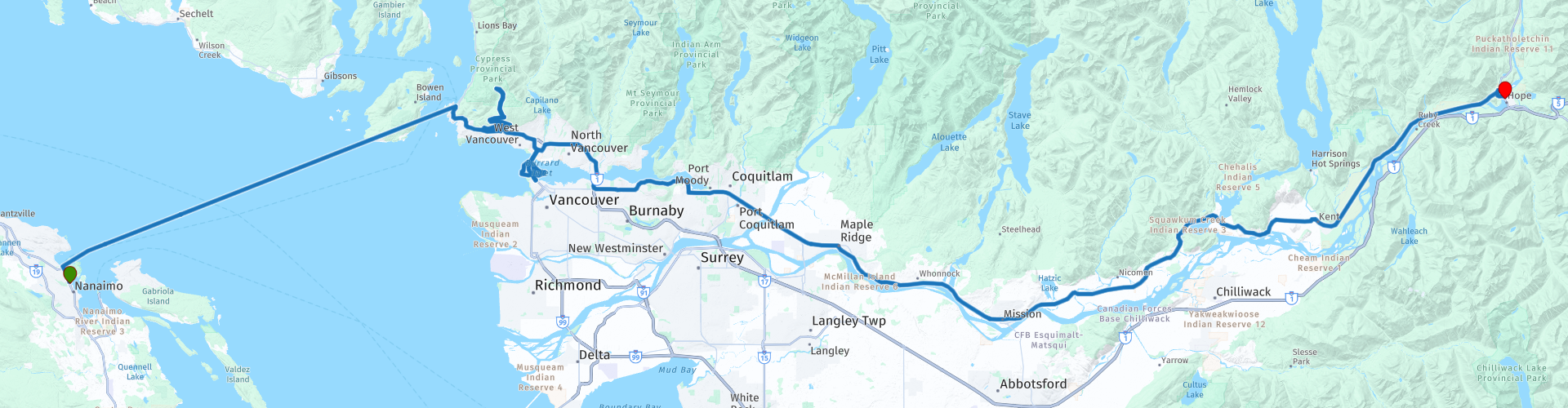
Day 02 TCH Nanaimo to Hope

This route was brought to you by:
RouteXpert René Plücken (MRA Master)
Last edit: 16-11-2025
 Route Summary
 This is part 2 which goes from Victory to Hope.
The Trans-Canada Highway passes through all of the country's southern provinces. The route can be driven in various ways, as there are several alternative routes that also belong to the Trans-Canada Highway. The total distance is around 8,000 km. We won't be driving solely the Trans-Canada Highway, but will be taking as much of the country's back roads as possible, as highway driving alone is too boring, and Canada boasts many beautiful roads through its stunning landscape.
You'll drive through all the provinces and through very diverse and picturesque landscapes, from the Rockies in the west, the Central Prairies to the eastern Maritimes and the northern forest.
The riding season is generally from April to October with longer seasons on the west coast and southern Ontario.
Make sure you have good all-season clothing or bring rain gear. Depending on the province and the season, the weather can change suddenly and you might be surprised by a rain shower, or even a snow or hail shower, so be prepared.
In Canada, the metric system is used, so speeds are indicated in km/h. Helmets are mandatory throughout Canada (DOT approved).
Throughout Canada, you'll see plenty of wildlife. Similar animals vary from province to province, including deer, buffalo, moose, caribou, wolves, cougars, bears, mountain goats, sheep, lynx, coyotes, foxes, raccoons, badgers, various rodents, and a variety of birds.
Even though it is very tempting to stop for a photo, don't do it, it can be very dangerous.
This second leg of the Trans Canada Highway is rated 4**** stars, it's a beautiful drive with stunning views and a good number of activities and sights along the way.
 Share this route


Animation

Verdict


Duration
8h 6m

Mode of travel
Car or motorcycle

Distance
288.77 km

Countries

 RouteXpert Review
 The morning sun glints off the water in Nanaimo as we start the engine and head for the ferry. Adventure beckons. Ahead lies the Horseshoe Bay Ferry, a crossing of just over an hour and a half that not only takes us to the mainland but also offers our first taste of British Columbia's grandeur. As the boat gently cuts through the water, a panorama of mountains unfolds, towering like sentinels above the bay. This is no ordinary ride—this is a journey through the heart of Canada's west coast.
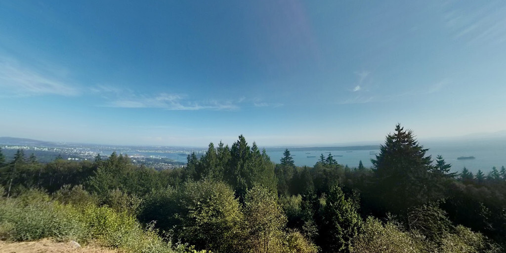
On shore in Horseshoe Bay, the real work begins. We turn onto the Trans-Canada Highway, but soon a side road beckons: Cypress Mountain. The road climbs steeply, winding through a series of hairpin bends. We stop briefly to enjoy the view: before us lies Vancouver, a city glistening in the sun, surrounded by water and mountains. The view is breathtaking, a moment to remember.
Back on the road, an icon awaits: the Lions Gate Bridge. This elegant suspension bridge, opened in 1938, spans Burrard Inlet. As we drive across, the concrete lions glide past us – silent witnesses to nearly a century of history. On the other side awaits Stanley Park, a 400-hectare green oasis in the heart of the city. We park and let ourselves be swept away by the park's magic: rainforest trails, beaches, mountain and ocean views. Canada's largest aquarium beckons, but we opt for lunch in one of the cozy restaurants. Here, amid the scent of pine and the sound of the ocean, Vancouver feels like a city that perfectly interweaves nature and culture.
After this break, we return to the Lions Gate Bridge, leaving the city behind. The road takes us to the Iron Workers Memorial Bridge, a place with a story. As we drive across, I think of the eighteen workers who lost their lives here during its construction—a memory that gives this bridge an extra dimension.
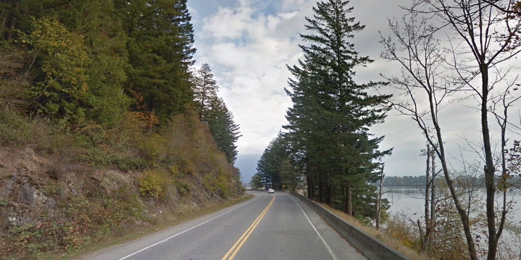
From Vancouver, we don't opt for the fast TCH route along the south side of the Fraser River. No, we're going for adventure: the northern route, part of which is Highway BC-7. Here, the road winds along the river, over impressive bridges, with views that make you stop repeatedly for a photo. The water glistens, mountains rise in the distance – this is driving as it was meant to be.
Towards evening, we reach Hope, a charming town surrounded by nature. Hotels, B&Bs, and a campsite await us here – a well-deserved rest after a day full of impressions. As the sun slowly sinks behind the mountains, I realize: this wasn't just a drive. This was a chapter in a larger story, a story that continues tomorrow.
 Links
Links  Usage
Usage Want to download this route?
You can download the route for free without MyRoute-app account. To do so, open the route and click 'save as'. Want to edit this route?
No problem, start by opening the route. Follow the tutorial and create your personal MyRoute-app account. After registration, your trial starts automatically.  Disclaimer
Use of this GPS route is at your own expense and risk. The route has been carefully composed and checked by a MyRoute-app accredited RouteXpert for use on TomTom, Garmin and MyRoute-app Navigation.
Changes may nevertheless have occurred due to changed circumstances, road diversions or seasonal closures. We therefore recommend checking each route before use.
Preferably use the route track in your navigation system. More information about the use of MyRoute-app can be found on the website under 'Community' or 'Academy'.

British Columbia
About this region
British Columbia (BC) is the westernmost province of Canada, situated between the Pacific Ocean and the Rocky Mountains. With an estimated population of 5.2 million as of 2021, it is Canada's third-most populous province. The capital of British Columbia is Victoria, the fifteenth-largest metropolitan region in Canada, named for Queen Victoria, who reigned over the British Empire at the time of Confederation. The largest city is Vancouver, the third-largest metropolitan area in Canada, the largest in Western Canada, and the second-largest in the Pacific Northwest. In October 2013, Greater Vancouver had an estimated population of approximately 2.5 million. Since 2017, the province has been governed by the New Democratic Party, led by John Horgan, first with a minority government elected in 2017 and subsequently with a majority government elected in 2020.
Read more on Wikipedia
View region
 Statistics
  15
15Amount of RX reviews (British Columbia)
 17014
17014Amount of visitors (British Columbia)
 564
564Amount of downloads (British Columbia)
 Route Collections in this region
 Top car and motorcycle tour through Canada USA and the Rockies
Traveling by car or motorcycle through Canada, USA and the Rockies is a journey that you don't just make, so don't drive for 15 days and then return home. No, book a stay of several days in Vancouver, Jasper, Banff, Seattle and Port Alberni and again Vancouver to also visit several places of interest in these cities, so that this tour becomes an unforgettable tour that you can remember with pleasure.
Do not forget to arrange and pack the following items:
*This is only a summary and completely personal and may differ per person.
Take out travel insurance, +31 for numbers in GSM, (partially) take out gas, Health insurance coverage at destination?, Switch off electrical appliances, Lighting (time clock), Check passport validity, Antenna from radio/TV due to lightning, Residence address for those left behind, Remote control house alarm, Book Smart Parking.
Hand luggage:
Liquids in packaging of max. 100 ml, Liquids in hand luggage in transparent plastic bag.
For on the road:
Candy, Book, Earplugs, Country and road map(s), Directions, Maps in your navigation system
Money & Securities:
Bank card / giro card, Credit card (think pin code), Cash, Calculator for Internet banking, Medical insurance card, Travel insurance card.
Travel documents:
Passport, (International) Driver's License, Ticket(s), Reservation Tickets, Hotel Vouchers, Arrival/Departure Time, Check-in & Check-out Times, Valid Visa (ESTA), Travel Guide.
Clothing:
Underwear, Belt, Shirts/ T-shirts, Shorts, Long pants, Shoes, Socks, Swim trunks, Towel, Slippers.
Personal stuff:
Watch, House Keys, Wallet, Sunglasses.
Toiletries:
Deodorant, Shower gel / Soap, Comb / brush, Shaving equipment, Shampoo, Toothbrush, Toothpaste, Sanitary pads
Health & Medicine:
Own medicines, Insect repellent, Cold sore ointment, Ointment for insect bites, Sunscreen, Norit, Paracetamol, Suction cup for insect bites, First aid bag.
Miscellaneous:
Travel bag / waist bag, Leatherman (= checked luggage), Pen or pencil, Headlamp, Lighter, Tools & Electronics, Mobile phone & charger, Photo/video camera & charger, Memory card(s), World plug / adapter, Ipod & charger, Adapter cable Ipod, Headphones, iPad & charger, Navigation & charger/plug, Plug socket, Fuelpack battery.
Engine (accessories):
Helmet, Motorcycle clothing, Motorcycle boots, Chain lock / disc brake lock, Gloves, Bandana, Inner bags (plastic shopping bag), Insulation bag, Tension straps, Tie wraps, Rain suit, Rainaway.
Addresses:
Address list, Embassy telephone number, Telephone number to block (bank) card(s), Telephone number (airline tickets).
View Route Collection
Trans Canada Highway
The Trans-Canada Highway (TCH) or Trans-Canadian Highway is a system of highways that cover all 10 provinces of Canada.
The Federal and Provincial Highways System that now forms the TCH were authorized by the Trans-Canada Highway Act of 1948 and opened in 1962. It was completed in 1971. The total length of the TCH is 7821 km.
Contrary to the American Interstate Highway System, the TCH does not consist of an unambiguous network of motorways, but forms a network of restricted access highways and other main routes that are more akin to the Dutch provincial roads. The route is indicated by a green shield with a white maple leaf.
The numbering of the roads that are part of the TCH is the domain of the provinces. Only the western provinces have aligned their numbering and the TCH has the designation Highway 1 there.
The main route of the TCH starts in Victoria in British Columbia and runs via Calgary and Regina to Winnipeg. From Winnipeg the route leads to Kenora in Ontario, after which several branches pass through Ontario to Ottawa.
Further east, the route passes through the province of Quebec via Montreal and Quebec, among others, to Moncton, New Brunswick. Then the TCH continues east through Nova Scotia, where a branch (via the Confederation Bridge) leads to Prince Edward Island. Another section runs down to the sea in the port city of Sydney, where a ferry service leaves for Channel-Port aux Basques on the island of Newfoundland. From there the route continues for more than 900 km to the provincial capital of St. John's, in the extreme southeast of the island.
We not only drive the TCH, but will take the rural roads as much as possible, because only Highway driving is too boring and Canada has many beautiful roads through its beautiful landscape. You drive through all provinces and through very varied and scenic landscapes, from the Rockies in the West, the Central Prairies to the Eastern Maritimes and the Northern Forest.
The riding season is generally April through October with longer seasons on the west coast and southern Ontario. Provide good all season clothing or bring rain gear, depending on the province and the season the weather can change and you may be surprised by a rain or even a snow or hail shower, so be prepared.
In Canada the metric system is used, so speeds are indicated in Km / h. A helmet requirement (DOT approved) applies throughout Canada.
You will see many wildlife throughout Canada. This varies from province to province, such as deer, buffalos, moose, caribou, wolves, pumas, bears, mountain goats, sheep, lynx, coyotes, foxes, raccoons, badgers, various rodents and all kinds of birds. Even if it is very tempting to stop for a photo, don't do it, it can be very dangerous.
The routes described in this review sometimes deviate from the Trans Canada Highway, bringing the total length to 9,300 kilometers. The routes are made so that you drive through the beautiful parts of Canada with truly beautiful panoramas and beautiful sights to visit, this differs from museums, parks to historical points. The routes are not too long so there is time to stop for photos and sights along the way. You can also choose to arrange and combine the stages differently or to add other routes to shorten or extend your journey. The routes are marked with a rating in stars, some routes are less challenging or interesting but are necessary to drive to the next point, which is why they often have a lower rating.
In the route description you will find more details about the routes and the points of interest along the way. These points and also hotels, restaurants, petrol stations etc. are indicated with a POI and sometimes also with a Route point. In the description you will also find links to interesting sites and to the routes that connect to that day.
The described routes are;
Day 01 TCH Victory to Nanaimo
Day 02 TCH Nanaimo to Hope
Day 03 TCH Hope to Kamloops
Day 04 TCH Kamloops to Revelstoke
Day 05 TCH Revelstoke to Lake Louise
Day 06 TCH Lake Louise to Calgary
Day 07 TCH Calgary to Medicine Hat
Day 08 TCH Medicine Hat to Moose Jaw
Day 09 TCH Moose Jaw to Regina
Day 10 TCH Regina to Brandon
Day 11 TCH Brandon to Winnipeg
Day 12 TCH Winnipeg to Kenora
Day 13 TCH Kenora to Ignace
Day 14 TCH Ignace to Thunder Bay
Day 15 TCH Thunder Bay to Marathon
Day 16 Thunder Bay to Wawa
Day 17 TCH Wawa to Sault Ste Marie
Day 18 TCH Sault Ste Marie to Espanola
Day 19 TCH Espanola to Mattawa
Day 20 TCH Mattawa to Ottawa
Day 21 TCH Ottawa to Montreal
Day 22 TCH Montreal to Quebec
Day 23 TCH Quebec to Riviere du Loup
Day 24 TCH Riviere du Loup to Grand Falls
Day 25 TCH Grand Falls to Fredericton
Day 26 TCH Fredericton to Moncton
Day 27 TCH Moncton to Charlottetown
Day 28 TCH Charlottetown to Truro
Day 29 TCH Truro to North Sydney
Day 30 TCH North Sydney to Corner Brook
Day 31 TCH Corner Brook to Grand Falls
Day 32 TCH Grand Falls to Clarenville
Day 33 TCH Clarenville to St John.
Have fun reading the reviews and planning your next road trip.
If you have driven this trip, I am very curious about your feedback!
View Route Collection