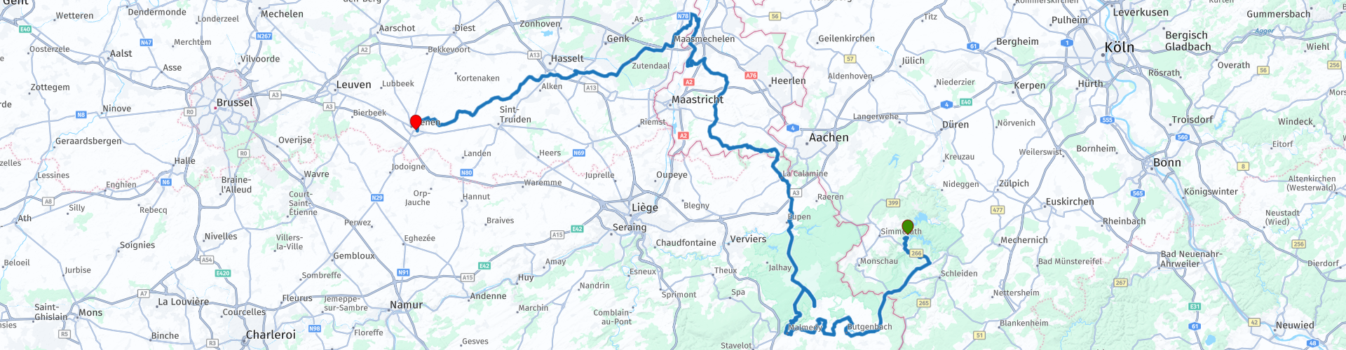
Rurberg to Tienen passing through the High Fens and the Eifel

This route was brought to you by:
RouteXpert Guy Heyns - Sr RouteXpert
Last edit: 10-12-2024
 Route Summary
 You will not only pass the High Fens, but you will also drive over the highest point of the Benelux while several well-known reservoirs slide past your wheels.
Pleasant road surfaces, nice curves, nice breaks and beautiful views will be your part on this return route from the Eifel.
 Share this route


Animation

Verdict


Duration
7h 18m

Mode of travel
Car or motorcycle

Distance
263.02 km

Countries


 RouteXpert Review
 We leave Rurberg via a nice winding road to cross the Belgian border for the first time after 24.5 km. You are still driving in the High Fens / Eifel area, but on Belgian soil. Pay attention to the adjusted speed limits!
After the nice passage of the Butgenbach reservoir and photo opportunity (rp 8) Elsenborn is reached, one of the highest villages in Belgium and 'famous' for its military camp.
Between route point 12 and 14 you will also pass the Robertville reservoir, which is known for its special water quality. Naturally, there is a lot of water sports activity around this reservoir.
The route takes you after Lake Robertville through the center of Malmédy where you can find a number of nice places to stop before starting the further winding route. This trail takes you through the High Fens along the Signal de Botrange (rp 20) and the Baraque Michel (rp 21). These two points are real landmarks in the Belgian landscape. The Signal de Botrange is today the highest point in Belgium (694 meters) after the annexation of the East Cantons. Previously, the Baraque Michel (rp 21) was the highest point in Belgium. In view of the beautiful nature reserve that lies here (De Hoge Venen), this region is frequently visited.
After passing through the High Fens you will return to an 'inhabited' area. Before you cross the border to the Netherlands at route point 26, you can choose to visit the three-country point in Vaals at route point 25. Please note that the parking spaces are theft-prone to bicycles and motorcycles! Depending on the season and weather, it can also be very busy here. Perhaps you can take this into account.
After route point 26, you drive through the Dutch Limburg hills, a particularly beautiful region that will undoubtedly conquer your heart. Beautiful road surface leads you in the direction of the Meuse valley where you literally cross the border with Belgium in the middle of the Meuse (rp 42). There is a break just before or after the ferry, but you can also choose to continue to the pleasant market square of Eisden (rp47) where you can get acquainted with an extensive Belgian beer menu in the café 'Marktzicht'. The nearby chip shop 'Friethof' is also recommended for a quick snack.
Depending on the (weather) circumstances, time of day, condition of the pilots and so on, you can decide to drive straight ahead at route point 48 and take the highway towards Lummen / Leuven to arrive in Tienen faster. But, if there is still time and desire, then the remaining 72 kilometers via the Belgian Limburg roads are also highly recommended. Admittedly slower, but still beautiful and nice to drive on good and solid road surfaces.
The route is long and requires a certain stamina from the pilots. They will arrive tired, but nevertheless satisfied at the Veemarkt in Tienen, where there are again enough parking spaces and opportunities to say goodbye. The quality of the road, the views and the distinctive, famous sights that you pass make this route a 5 star route. There may be fewer 'technical' challenges with extensive cornering, but remember that the length of the route and the required concentration on rural roads are also important elements that play a role in the driving skills of the pilots. That is why we do not recommend this beautiful, but tiring route to novice pilots. A minimum of experience is required, especially when you combine it with a few days of Eifel cornering.


 Links
Links  Usage
Usage Want to download this route?
You can download the route for free without MyRoute-app account. To do so, open the route and click 'save as'. Want to edit this route?
No problem, start by opening the route. Follow the tutorial and create your personal MyRoute-app account. After registration, your trial starts automatically.  Disclaimer
Use of this GPS route is at your own expense and risk. The route has been carefully composed and checked by a MyRoute-app accredited RouteXpert for use on TomTom, Garmin and MyRoute-app Navigation.
Changes may nevertheless have occurred due to changed circumstances, road diversions or seasonal closures. We therefore recommend checking each route before use.
Preferably use the route track in your navigation system. More information about the use of MyRoute-app can be found on the website under 'Community' or 'Academy'.