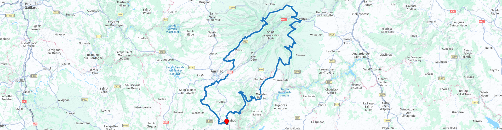
Roundtrip from Labesserette to the Puy Mary

This route was brought to you by:
RouteXpert Catherine De Groote RouteXpert
Last edit: 22-11-2020
 Route Summary
 The area around the Puy Mary was formed up to 70,000 years ago by volcanic eruptions in which the lava was ejected into the distant surroundings of this volcano. You can still see that in many places in the valleys around the Puy Mary. The Puy Mary is one of the highest mountains in the Cantal Mountains in the Massif Central. The top is located at an altitude of 1783 meters. The summit is accessible from Pas de Peyrol, the highest mountain pass in the Massif Central. The Cantal Mountains are an extraordinary area.
 Share this route


Animation

Verdict


Duration
5h 2m

Mode of travel
Car or motorcycle

Distance
235.18 km

Countries

 RouteXpert Review
 We leave the Aubrac via small, winding roads with here and there a hairpin bend and gradually climb to the mountains of the Cantal. Forests and open landscape alternate. Here and there you come in or along a small village: a few houses, a church, a few farms ...
The Col de la Grifoul (RP 8) is the fourth highest pass in Cantal with an altitude of 1,336 m. The Col connects the valley of the Epie with the valley of Brezons. It's huge and majestic.
The Col de Prat de Bouc (RP 9) is one of the characteristic places of Cantal. Located at an altitude of 1,392 m, the site is majestic in the shape of a circus. It is located to the east of Plomb du Cantal.
The Buron of the Col de Prat de Bouc welcomes you in an authentic and warm environment. You can taste regional specialties such as truffles, cold cuts from local producers, the pashade and blueberry pie ...
A last pass before you descend to Murat is the Col de la Molède (1329 m) (RP 10). When turning left on the N122, you can have a lunch stop here. In the Le Relais des Trois Rochers (RP 12) you can eat very well.
The castle of Anterroches (RP 13) is a medieval castle and you will see it on your right when you leave Murat. Built in the Middle Ages, it was significantly modified in the nineteenth century in the troubadour style with battlements, turrets and mullions.
You follow the N122 for three kilometers and then turn right to the Pas de Peyrol. In Dienne you can admire the Château de la Cheyrelle (RP 16). It is now a hotel, but it can also be visited. In 2020, there were repairs, which meant that it was temporarily impossible to visit. It is therefore best to consult the website first (link below). Located at an altitude of 1,100 m, the Château de la Cheyrelle is a mansion built in the 19th century on the foundations of an old medieval barn where agricultural activity continued until the 1990s. But it was at the beginning of the 20th century, between 1903 and 1905, that the castle took on its final shape and uniqueness with the transformation works. The castle was decorated both inside and out by the Belgian interior designer Serrurier-Bovy, from 1903 to 1905, to which he applied his aesthetic theories (clarity, rationality, functionalism).
Col d'Eylac (RP 18) is a mountain pass at an altitude of 1,442 m. The road to the top is quite steep (a maximum gradient of 15%).
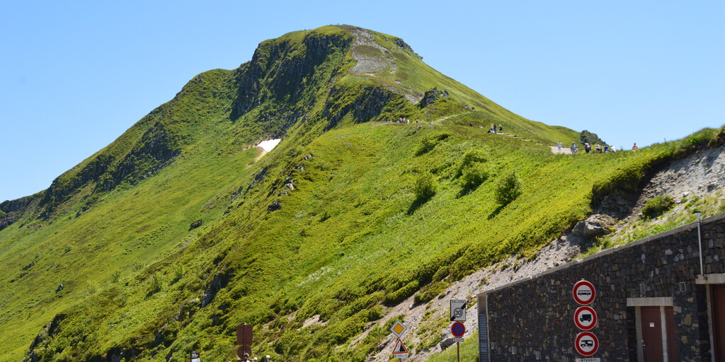
A few more turns and you are on the Pas de Peyrol (1598 m) (RP 19). The road is known as the highest through road in the Massif Central. The pass crosses a ridge between the Puy Mary (1783 m) and the Puy de la Tourte (1704 m) and connects the valleys of the Mars and the Santoire, two rivers that have cut deep into the flanks of the old stratovolcano of the Cantal (the largest stratovolcano in Europe). A concrete path leaves from the col to the top of the Puy Mary.
Via a beautiful descent and beautiful views you drive to the Col Croix de Cheules (907 m) (RP 24). There is a brasserie of the same name where you can taste their snacks, pancakes, waffles, ice creams or just relax around a tea, a cup of coffee or something else ...
You now continue towards Aurillac along winding roads with a few hairpin bends.
Located in Arpajon-sur-Cère, the Castle of Conros (RP 30), a historical monument, is an elegant medieval building renovated in the Renaissance, which dominates from its rocky point over a meander of the Cère. Inhabited since 1130, it comprises an impressive castle tower, two round towers, one with a cantilevered gallery and a main building. The Castle of Conros is home to the folk museum of art and tradition of the Cère Valley. Housed in the former kitchens, it gives a picture of rural life in the 19th century, as well as a permanent exhibition on perfumes. Under its impressive lauze roof, one of the largest in Cantal, you can admire, among other things, a beautiful vaulted armory, enormous fireplaces, a Renaissance staircase, and a chapel containing a white marble Merovingian sarcophagus, discovered in 1988 in Arpajon-sur-Cère .
In the romantic park around the castle, where you can take a lovely walk, you will find many fragrant plants and remarkable trees: a tulip tree, cedars, and even an ancient beech!
The castle can only be visited with a guide. Guided tours every day from 2 pm to 6 pm, from July 1 to September 10 from 2:30 pm to 6:30 pm. The park is open from Easter to All Saints' Day (10am - 7pm). Entrance fee to the park, reserved for visitors to the castle. Entrance price: 5.30 euros / person.
From here it is about 25 km to enjoy the wide, slightly hilly landscape to the holiday home.
The landscape is very varied: from woodland to extensive views, small villages, mountains and winding rivers. You mainly drive on narrow roads that wind their way through the landscape with here and there hairpin bends. The courses are also in excellent condition. This region is mainly known for its nature and beautiful green mountains. This tour also receives 5 stars.

 Links
Links  Usage
Usage Want to download this route?
You can download the route for free without MyRoute-app account. To do so, open the route and click 'save as'. Want to edit this route?
No problem, start by opening the route. Follow the tutorial and create your personal MyRoute-app account. After registration, your trial starts automatically.  Disclaimer
Use of this GPS route is at your own expense and risk. The route has been carefully composed and checked by a MyRoute-app accredited RouteXpert for use on TomTom, Garmin and MyRoute-app Navigation.
Changes may nevertheless have occurred due to changed circumstances, road diversions or seasonal closures. We therefore recommend checking each route before use.
Preferably use the route track in your navigation system. More information about the use of MyRoute-app can be found on the website under 'Community' or 'Academy'.

Occitanie
About this region
Occitanie (French pronunciation: [ɔksitani] (listen); Occitan: Occitània [utsiˈtanjɔ]; Catalan: Occitània [uksiˈtaniə]), Occitany or Occitania (), is the southernmost administrative region of metropolitan France excluding Corsica, created on 1 January 2016 from the former regions of Languedoc-Roussillon and Midi-Pyrénées. The Council of State approved Occitanie as the new name of the region on 28 September 2016, coming into effect on 30 September 2016.The modern administrative region is named after the larger cultural and historical region of Occitania, which corresponds with the southern third of France. The region Occitanie as it is today covers a territory similar to that ruled by the Counts of Toulouse in the 12th and 13th centuries. The banner of arms of the Counts of Toulouse, known colloquially as the Occitan cross, is used by the modern region and is also a popular cultural symbol. In 2015, Occitanie had a population of 5,839,867.
Read more on Wikipedia
View region
 Statistics
  83
83Amount of RX reviews (Occitanie)
 32278
32278Amount of visitors (Occitanie)
 4416
4416Amount of downloads (Occitanie)
 Route Collections in this region
 25 Magnificent trails in France
This MRA route collection contains 25 beautiful motorcycle routes in different parts of France, such as the Ardennes, the Alsace, Vercors, the Drôme, the Ardèche, Cote d'Azure, Gorges du Verdon, the Ariège, the Dordogne and Brittany.
The routes have been carefully created by Bert Loorbach, who is an enthusiastic motorcyclist himself. He lived in France for a year and a half, during which time he devoted himself to mapping the unknown and beautiful back roads of France especially for motorcyclists.
The routes are bundled in the Motortourgids France part 1 of Kosmos publishing house and now also available in MyRouteApp.
I have taken over the routes in MRA and sometimes adjusted them slightly to make them even more interesting for the motorcyclist.
View Route Collection
24 Magnificent trails in France
It is clear that France is one of the most beautiful and best touring countries. It offers an incredibly varied landscape with good roads and a pleasant climate. It is not for nothing that you see so many motorcyclists there. My previous collection of 25 routes in France (25 Magnificent routes in France) were based on the route descriptions from the Motortourgids France part 1 made by Bert Loorbach.
This collection of 24 routes comes from Motortourgids France part 2. In this collection, a difference has been made between approach routes and motorcycle tours in a certain area. The approach routes can also be used in combination with the routes from Motortourgids France part 1
The routes are sometimes slightly adjusted based on the tips that Bert Loorbach gives in his description, or because of another place to spend the night, or to reach the minimum length of 2 hours for the MRA Library. For each route, the review contains a more detailed description, including options to stay overnight or places of interest along the way, which are also indicated with a POI and if possible with a short description.
Two or more routes have been created for a number of areas, such as for Burgundy, Auvergne, The Alps, Tarn and Cévennes and Nord-Pas de Calais. These routes can be nicely combined in a multi-day trip.
View Route Collection