Roundtour Signal de Lure

This route was brought to you by:
RouteXpert Peter Moerman - RouteXpert
Last edit: 18-10-2021
 Route Summary
 It is a slightly shorter route so you have enough time to visit the towns. The roads are fine and you can enjoy driving on large parts.
The Cols are not very difficult to ride but do have some sharp hairpin bends where you have to be careful.
We have driven this route and variations on it several times ourselves in recent years and enjoy the beautiful and varied surroundings again and again.
I give this route 4.5 stars because of the attractive surroundings, the many sights and the excellent and challenging roads.
This route is part of a series of routes in this area, all starting from a great motorcycle hotel.
 Share this route


Animation

Verdict


Duration
8h 34m

Mode of travel
Car or motorcycle

Distance
285.13 km

Countries

 RouteXpert Review
 The Drôme department is part of the Auvergne-Rhône-Alpes region. It is bordered by the departments of Ardèche, Isère, Hautes-Alpes, Alpes-de-Haute-Provence and Vaucluse. The canton of Valréas, called Enclave des papes until the French Revolution, belongs to the department of Vaucluse, but is completely surrounded by the department of Drôme.
The department takes its name from the river Drôme, a tributary of the Rhône, with a length of 110 km.
Alpes-de-Haute-Provence is surrounded by the departments of Alpes-Maritimes, Var, Vaucluse, Drôme and Hautes-Alpes as well as by Italy. Important city: Manosque, largest city in the department, although not even a sub-prefecture. Watercourses: Durance, Verdon, Bléone, Ubaye, Var, Buëch, Jabron, Largue. The Verdon (regional nature park) lies on the border with the Var department.
The Vaucluse department was created in 1793 from parts of Bouches-du-Rhône, Drôme, and Basses-Alpes (now Alpes-de-Haute-Provence). In 1791, by popular vote in the former Papal State, Comtat Venaissin, it had been elected to join the Vaucluse. The department was named after the village of Vaucluse, which has been called Fontaine-de-Vaucluse since 1946. Vaucluse is surrounded by the departments of Gard and Ardèche to the west, Drôme to the north, Bouches-du-Rhône and Var to the south and Alpes-de-Haute-Provence to the east. The canton of Valréas is an exclave of Vaucluse, surrounded by the territory of the department of Drôme. Sometimes the Enclave des papes is referred to in this context, literally the 'Papal enclave'.
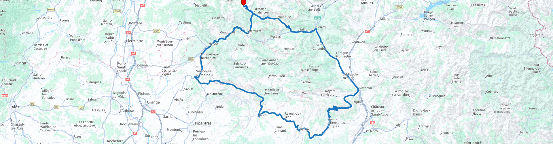
The route starts and ends at the village of Chalancon at Motovacances Chamauche, a great base for exploring this region. From the start it goes straight down to La Motte de Chalancon. After about 14 kilometers you drive past a geological site that was only discovered in 1977 and where all kinds of rocks can be seen.
The route continues through a valley towards the Col de Tourettes where it pays to get off and enjoy the view from both sides. Driving up the beautiful curves with excellent asphalt is always a pleasure for motorcyclists. The descent is a bit more careful because there are some blind bends. After the descent, turn left onto the D994 towards Serres, where a refueling stop is planned at the exit of the village.
After that, it continues to the beautiful town of Sisteron where it is well worth stopping and seeing the city. The town lies on the river Durance. Sisteron is also called the gateway to Provence by some, because the town lies between two large mountain passes. Excavations near the present site have shown that the area around the town has been inhabited for over 4000 years. The Romans made frequent use of the trade route that ran through the town. The city has never had to deal with Barbarian raids and looting. Even during the fall of the Roman Empire, the town was spared from raids by barbarian tribes.
Later in history, however, the city would face many setbacks. In the fifteenth century the city was affected by the Plague. This disease caused death and destruction among the people of Sisteron. Only one third of the total population survived the Plague. Between 1562 and 1594 the city was confronted with the French Wars of Religion. This included heavy fighting for the Citadel, which led to many deaths among the civilian population. In 1630, Sisteron again had to deal with the Plague. In 1744 the disease typhus again led to many deaths.
Today Sisteron is a nice city to visit. The city is best known for its large Citadel. This citadel is located on a hill and overlooks the town. Besides the citadel, the cathedral of Sisteron is also interesting to visit. This one is dedicated to the Blessed Virgin. There are many beautiful streets in the town. The old town has not lost its charm over the years. The cozy terraces ensure that you can easily spend a day here. There are also a few museums that you can visit.
You continue your route via the D53 to the Pas de la Graille. Most of the 18 km climb goes through the woods on a not too wide asphalt road that is quite bumpy here and there. Due to the steep slopes you have beautiful views through the trees in various places. With a gradient of up to 7%, the road is not very steep. It pays to stop at the parking lot and walk to the viewpoint. Here you will be rewarded with a fantastic view from the 1597 meter high pass.
From Pas de Graille it is only 4 kilometers to Signal de Lure, the namesake of this route. You are now above the tree line. This mountain is also called the little sister of Mont Ventoux due to its bare top. At 1736 meters, this mountain is not yet as high as Mont Ventoux, but it is also increasingly popular with cyclists. The views are even wider from here. Be sure to stop at the parking lots and walk to the viewpoints. They will not disappoint you provided the weather is good. Via an equally winding descent you drive south to Saint Etienne les Orgues where you turn right onto the D951 towards Sault.
Sault is an old fortified village, situated on a rocky outcrop of the 'Plateau de Vaucluse'. The village overlooks 'Val de Sault', a beautiful valley with large lavender fields. The village is located in the middle of countless beautiful excursions and walks such as the Mont Ventoux, the Gorges de la Nesque, the Valley of the Toulourec, the plateau of Albion, the Lubéron and other natural areas in the Provençal Drôme and the Alpes-de-Haute- Provence. Sault and its surroundings are a UNESCO protected area. The name 'Sault' is derived from the Latin 'Saltus', which means 'land of forests'. Excavations have shown that the present-day town has its origins in prehistoric times. To the northeast of the town, in the Bois du Défens, prehistoric objects have been excavated near a cave.
To the west of the village, remains dating from the Roman Empire have been found on the banks of the river. From the 11th century, the barons of Agoult ruled Sault and its surroundings for five centuries. This rule came to an end at the time of the French Revolution, where the Count of Villeroy was put to death by guillotine. In the 18th and 19th century this town was the center of the glass industry. There are no traces of this today, except perhaps in the fact that a lot of glassware is offered at the weekly markets. Also in the municipal museum of Sault you can admire a natural history collection of antique objects, which have mainly been excavated in the village and its surroundings. Today, tourism plays a major role in the village, as evidenced by the presence of several cafes, restaurants and shops with local and regional products. As in Bédoin, you will undoubtedly encounter cyclists in this town. The town is, like Bédoin, one of the three 'official' starting points for climbing the nearby Mont Ventoux by bicycle.
The lunch stop is also planned in Sault. You will probably find something to your liking on one of the many terraces.
The last part of the route first heads west on the D40 to Vaisson la Romaine, but if you can't resist and left early this morning, you could also accidentally take the D164. You are then suddenly on top of Mont Ventoux within half an hour. Nice bonus anyway. Via Malaucène you will also arrive in Vaison la Romaine. It will cost you an extra half hour, but you will get a very nice extra way in return.
Today, in particular, the Roman history of Vaison-la-Romaine is still clearly visible. For example, two Roman neighborhoods have been excavated in the city, named Puymin and La Vilasse. These two excavations can be visited for a fee. The Roman theater has been almost completely restored and can also be visited. Besides the Roman excavations, the old part of Vaison-la-Romaine is also worth a visit. This old part is located higher up the mountain. The old part of Vaison-la-Romaine is connected by an old Roman bridge over the river Ouvèze to the newer part of the city. A visit to Vaison-la-Romaine is highly recommended. There is a lot to see and experience! A refueling stop is also planned in Vaison la Romaine.
From here it is another 60 kilometers to the end of this route Motovacances Chamauche. The road from Nyons to Remuzat is certainly very rewarding for motorcyclists, beautiful asphalt and long keepers. Let's hope there are no slow tourists driving for you.


 Links
Links  Usage
Usage Want to download this route?
You can download the route for free without MyRoute-app account. To do so, open the route and click 'save as'. Want to edit this route?
No problem, start by opening the route. Follow the tutorial and create your personal MyRoute-app account. After registration, your trial starts automatically.  Disclaimer
Use of this GPS route is at your own expense and risk. The route has been carefully composed and checked by a MyRoute-app accredited RouteXpert for use on TomTom, Garmin and MyRoute-app Navigation.
Changes may nevertheless have occurred due to changed circumstances, road diversions or seasonal closures. We therefore recommend checking each route before use.
Preferably use the route track in your navigation system. More information about the use of MyRoute-app can be found on the website under 'Community' or 'Academy'.

Provence Alpes Cote d Azur
About this region
Provence-Alpes-Côte d'Azur (French pronunciation: [pʁɔvɑ̃s‿alp kot d‿azyʁ]; Occitan: Provença-Aups-Còsta d'Azur, [pɾuˈvɛnso̞ ˈawps ˈkɔsto̞ daˈzyɾ], or Provença-Alps-Còsta d'Azur, [pɾuˈvɛnso̞ ˈalps ˈkɔsto̞ daˈzyɾ]; commonly shortened to PACA; English: Provence-Alps-French Riviera; also known as Région Sud) is one of the eighteen administrative regions of France, the far southeastern on the mainland. Its prefecture and largest city is Marseille. The region is roughly coterminous with the former French province of Provence, with the addition of the following adjacent areas: the former papal territory of Avignon, known as Comtat Venaissin; the former Sardinian-Piedmontese County of Nice, whose coastline is known in English as the French Riviera and in French as the Côte d'Azur; and the southeastern part of the former French province of Dauphiné, in the French Alps. Previously known by the acronym PACA, the region adopted the name Région Sud as a commercial name or nickname in December 2017. 5,007,977 people live in the region according to the 2015 census.
It encompasses six departments in Southeastern France: Alpes-de-Haute-Provence, Alpes-Maritimes, Bouches-du-Rhône, Hautes-Alpes, Var and Vaucluse. It is bounded to the east by the France–Italy border, to the south by the Mediterranean Sea and by the Principality of Monaco, to the north by Auvergne-Rhône-Alpes and to the west by Occitanie, with the Rhône marking its westernmost border. The region logotype displays the coat of arms created in the 1990s and which combines the coats of arms of the old provinces making up Provence-Alpes-Côte d'Azur. The region's economy is the third largest in France, just behind Île-de-France and Auvergne-Rhône-Alpes. Its GDP in 2012 was €142.4 billion (US$183.1 billion) while its per capita GDP was €28,861 ($US 37,121).
Read more on Wikipedia
It encompasses six departments in Southeastern France: Alpes-de-Haute-Provence, Alpes-Maritimes, Bouches-du-Rhône, Hautes-Alpes, Var and Vaucluse. It is bounded to the east by the France–Italy border, to the south by the Mediterranean Sea and by the Principality of Monaco, to the north by Auvergne-Rhône-Alpes and to the west by Occitanie, with the Rhône marking its westernmost border. The region logotype displays the coat of arms created in the 1990s and which combines the coats of arms of the old provinces making up Provence-Alpes-Côte d'Azur. The region's economy is the third largest in France, just behind Île-de-France and Auvergne-Rhône-Alpes. Its GDP in 2012 was €142.4 billion (US$183.1 billion) while its per capita GDP was €28,861 ($US 37,121).
View region
 Statistics
  61
61Amount of RX reviews (Provence Alpes Cote d Azur)
 64704
64704Amount of visitors (Provence Alpes Cote d Azur)
 4468
4468Amount of downloads (Provence Alpes Cote d Azur)
 Route Collections in this region
 The 24 Most Beautiful Alpine Routes
The Alps, The Alps are a mountain range in Europe, stretching from the French Mediterranean coast in the southwest to the Pannonian Plain in the east. The area of the mountain range is more than 200,000 km².
In other words Passes and Mountain Roads!
Driving through the mountains is great! Especially over the mountain passes with hairpin bends and narrow winding roads. Every bend a different view where you can enjoy. There are many beautiful mountain passes in the Alps.
A selection that has also been incorporated into these routes:
The Stlevio Pass:
The Stelvio Pass, also known as Passo dello Stelvio, is mainly known for the stage in the Giro d'Italia. Due to the length and the difference in height, this pass is seen as one of the toughest tests in cycling. The Stelvio Pass reaches a maximum height of 2758 meters and is therefore one of the highest in the Alps. The pass connects the towns of Bormio and Prato Allo Stelvio. In winter the pass is closed due to heavy snowfall.
The Reschenpass:
The Reschenpass, also known as Passo di Resia, connects the Austrian state of Tyrol with the Italian province of South Tyrol. The pass reaches a maximum height of 1,504 meters and has been one of the most important north-south connections in the Alps in recent centuries. The pass was used long before Roman times. Along the way you will pass several highlights and historical relics. One of the highlights is the Reschensee. This lake was created after the construction of the dam and has completely submerged the village of Graun. The only thing that reminds of that is the clock tower in the middle of the lake.
Col du Galibier:
The French mountain pass Col du Galibier connects the towns of Saint-Michel-de-Maurienne and Briançon via the Col du Lautaret in the south and the Col du Télégraphe in the north. The mountain pass is part of the Tour de France and very much feared, due to the fact that it can only be reached via the other two mountain passes. The pass reaches a maximum height of 2646 meters. From there you can take a walk to the viewpoint at 2704 meters. You can admire the peaks of the Grand Galibier, Mont Blanc and La Meije here.
The Grossglockner High Alpine Road:
With a height of 3798 meters the Grossglockner is the highest mountain in Austria. To fully enjoy this impressive mountain, you can drive over the Grossglockner High Alpine Road and the accompanying pass. The route starts from Bruck am Grossglockner and ends in Heiligenblut. Of course you can drive in two directions. The pass reaches a maximum height of 2504 meters and is closed in winter due to heavy snowfall. Along the way you pass several stops with fun activities, information points, mountain huts and viewpoints. A visit to the Kaiser-Franz-Josefs-Höhe and Pasterzen Glacier is highly recommended.
The Col d'Izoard:
Just like the Col du Galibier, the Col d'Izoard is also part of a stage of the Tour de France. The mountain pass connects Briançon with the valley of the river Guil. The pass is partly located in the Regional Natural Park du Queyras and reaches a maximum height of 2360 meters. What is special about the Col d'Izoard is the barren and rocky landscape. Sometimes it feels like driving a car over the moon! Along the way you can stop at several points to enjoy the beautiful view.
The Bernina Pass:
The Bernina Express is one of the most famous rail trains in Switzerland and the Alps. The route is beautiful and partly included on the UNESCO World Heritage List. Parallel to the railway lies the Bernina pass, which connects the Veltlin valley with the Egandin valley. This beautiful Alpine road has a total length of 56 kilometers and reaches a maximum height of 2328 meters. Along the way you can enjoy views of the Morteratsch Glacier.
The Sella Pass:
The Sella Pass, also known as Passo di Sella, takes you over one of the most impressive mountain ranges in the Dolomites: the Sella massif. The pass connects Valle di Fassa with Val Gardena and reaches a maximum height of 2236 meters. At this height is also the border of the Italian provinces of Trentino and Bolzano. Along the way you can enjoy the view of this spectacular mountain world. Admire, for example, the three peaks of the Sasso Lungo massif, the Sella massif or the peaks of the Marmolada. You can also drive the Sella pass in combination with the Gardena pass, Pordoi pass and Campolongo pass.
The Grimsel Pass:
The Grimsel Pass connects Goms in Wallis with the Halis Valley in the Bernese Oberland. The pass reaches a maximum elevation of 2165 meters and is closed in winter due to snowfall. Over the centuries, the mountain pass has played an important role in trade between Switzerland and Italy. Now it is mainly the reservoirs that have an important function. These are used to generate electricity. The landscape you drive through is rugged, rocky and impressive. On top of the pass is a hotel and a restaurant with a special marmot park. The Dodensee (Totensee) is also located here. This lake owes its name to the many soldiers who died in the time of Napoleon.
The Gotthard Pass:
The Gotthard Pass, also known as Passo del San Gottardo and Saint Gotthard, connects the Swiss towns of Airolo and Andermatt. The mountain pass and associated tunnel are especially known among holidaymakers driving from Switzerland to Italy. But where the majority opt for the tunnel, it is precisely the pass that really completes the holiday. The Gotthard Pass has a length of about 26 kilometers and reaches a maximum height of 2106 meters. The route is beautiful and takes you along old villages and beautiful views.
The Silvretta High Alpine Road and Silvretta Pass:
The Paznaun Valley in Tyrol and the Montafon in Vorarlberg are connected by the Silvretta High Alpine Road. The route has a length of 22.3 kilometers and leads from Galtür to Partenen in 34 hairpin bends, via the 2032 meter high Bielerhöhe. The Silvrettasee is also located at this point, where you can enjoy a lovely walk. The pass is closed in winter due to snowfall.
The Simplon Pass:
Just like the Gotthard Pass, many holidaymakers also travel over the Simplon Pass every year. This mountain pass connects the Rhone Valley in the canton of Valais with the Valle d'Ossola in Piemonte. The pass is open all year round and reaches a maximum height of 2005 meters. Along the way you pass a number of buildings, including the well-known Simplon Hospiz from 1825. The hospiz is managed by the monks of St. Bernard. From the highest point on the pass, all kinds of hiking routes are possible and you will also come across a hotel where you can spend the night.
The Gerlos Pass:
The Gerlos Pass connects the Salzach Valley in the Salzburgerland with the Zillertal Valley in Tyrol. The pass is part of the Gerlos Alpenstraße and runs right through the Hohe Tauern National Park. Along the way you can enjoy beautiful views of the surroundings. The pass has a length of 12 kilometers and reaches a maximum height of 1531 meters. A ride over the Gerlos Pass can be ideally combined with a visit to the Krimmler Wasserfälle.
The Great St. Bernard Pass:
The Great St. Bernard Pass, better known as Col du Grand Saint Bernard, connects the Italian province of Valle d'Aosta with the Swiss canton of Valais. The pass is one of the highest in Switzerland and reaches a maximum height of 2469 meters. Like a number of other mountain passes in this list, the Great St. Bernard Pass has also been used as a connecting road for centuries. The pass is named after the St. Bernard dogs that used to help stranded travelers along with the monks. The pass is closed in winter.
The Timmelsjoch High Alpine Road:
The Timmelsjoch High Alpine Road connects the towns of Sölden in the Ötztal and Meran in South Tyrol. Tolls must be paid on the Hochgurgl - Moos route. Via a mountain road with about 60 hairpin bends you drive through a beautiful mountain world. With the Timmelsjoch Experience you can learn more about the history, the road and the environment via various stations. You can also visit the Top Mountain Crosspoint museum.
Col de l'Iseran:
With a maximum pass height of 2770 meters, the Col l'Iséran is one of the highest mountain passes in the Alps. The pass connects Bourg-Saint-Maurice with Bonneval-sur-Arc. Via a road full of hairpin bends you pass, among other things, Val-d'Isère and a side valley of the Maurienne that lies entirely in the National Park de la Vanoise. You can spot animals such as marmots and chamois and there is also a restaurant with a chapel on top of the pass.
The Gavia Pass:
The Gavia Pass (Italian Passo di Gavia) is a mountain pass in the Italian Alps, in the Lombardy region.
It is one of the highest pass roads in Europe. The road leads through the unspoilt Stelvio National Park. The road was built in the First World War to supply Italian soldiers who fought in the Italian-Austrian border area. The pass height is one of the most beautiful in the Alps. Here is the large Lago Bianco with, to the north, the mountain San Matteo (3684 meters). Lago Nero is slightly lower on the south side of the pass. Here the mountain group of the Adamello determines the view. There are many well-marked walks in the area. During the winter the pass is closed due to the heavy snowfall. The pass is often closed until May and June due to the large amount of snow.
Promoter has made a selection of the 24 Most Beautiful Alpine routes that they have set out in recent years.
The routes go through:
France
Austria
Switzerland
Italy
The most beautiful roads, the most beautiful views, the most beautiful viewpoints. The highest mountains, the fastest descents, hairpin bend after hairpin bend, you name it you can't get enough of it.
If you go on holiday in this region, take advantage of it, ALL routes in this collection have been checked and made equal for TomTom, Garmin and MyRoute-app Navigation by a MyRoute-app RouteXpert.
Have fun with this collection and while driving one of these routes. Enjoy all the beauty that the Alps and the Dolomites have to offer. Click on “View route” to read the review of the chosen route.
I would like to hear your findings about the route(s).
View Route Collection
25 Magnificent trails in France
This MRA route collection contains 25 beautiful motorcycle routes in different parts of France, such as the Ardennes, the Alsace, Vercors, the Drôme, the Ardèche, Cote d'Azure, Gorges du Verdon, the Ariège, the Dordogne and Brittany.
The routes have been carefully created by Bert Loorbach, who is an enthusiastic motorcyclist himself. He lived in France for a year and a half, during which time he devoted himself to mapping the unknown and beautiful back roads of France especially for motorcyclists.
The routes are bundled in the Motortourgids France part 1 of Kosmos publishing house and now also available in MyRouteApp.
I have taken over the routes in MRA and sometimes adjusted them slightly to make them even more interesting for the motorcyclist.
View Route Collection