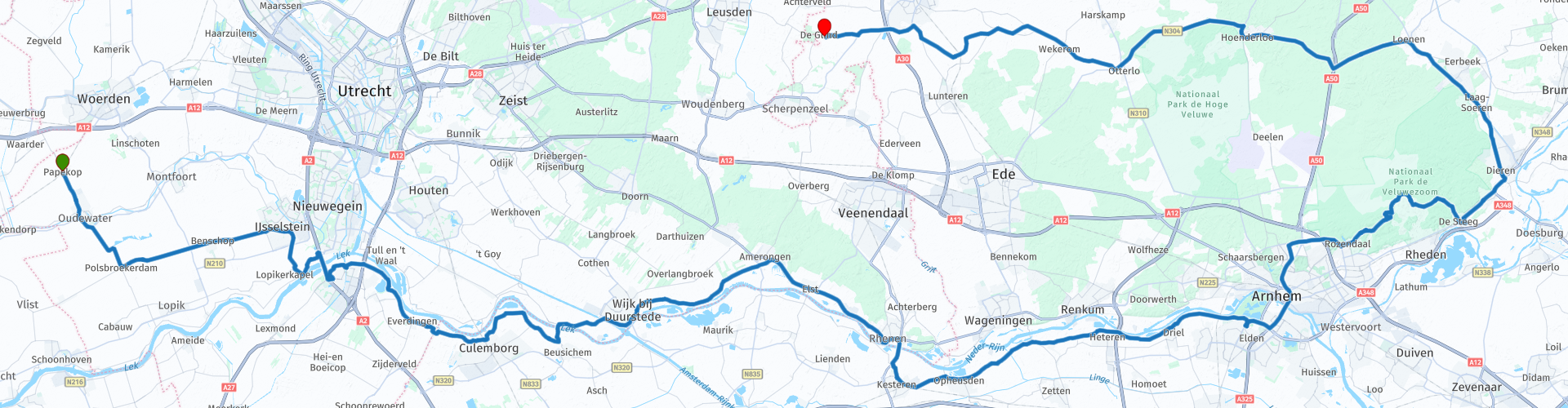
Papekop via de Lek en Rijn over de Posbank naar de Glind Barneveld

This route was brought to you by:
RouteXpert Dick Schaap
Last edit: 17-01-2022
 Route Summary
 This route is optimized for TomTom, Garmin and MRA NavApp.
I drove the route in 2021. Because of the beautiful curves along the Nerdrijn and on the route to the Posbank, the view and the passages of historical works, this route more than deserves 5 stars
Pay attention!
Pont Beusichem - Wijk bij Duurstede, rate 2021 motor: € 1.50 car: € 2.50. NO PIN
 Share this route


Animation

Verdict


Duration
7h 23m

Mode of travel
Car or motorcycle

Distance
178.75 km

Countries

 RouteXpert Review
 The route continues into Arnhem over the infamous and famous John Frost Bridge (formerly: the Rhine Bridge). The Rhine Bridge, where many soldiers were killed in WWII, is known for the Battle of Arnhem and Operation Market Garden. After Arnhem of course Rozendaal, the beginning of the Veluwezoom, direction Posbank. Also a beautiful route with as "icing on the cake" the hairpin bends in the Bovenallee and the Beekhuizenseweg, which are feared by novice motorcyclists. A stop at the top of the Posbank (90m above NAP) is recommended. A wide Heide area with its beautiful views, viewpoints and hiking trails in all directions.
After the Posbank there is a small detour in De Steeg past Castle Middachten. This is followed by varied landscapes of Ellecom, Dieren, Laag Soeren and, last but not least, the Deelerwoud. Open Coulisse landscape after Otterlo, inviting, good steering, smooth ride towards the end of the route in the Youth Village “De Glind”, at Grand Café Ons.
The Glind deserves special attention. It is an ordinary village near Barneveld. Children grow up here who have been placed out of their homes. The village has everything young people need. They live in a family home or small-scale treatment facility, go to school and follow work-study programmes. There are all kinds of facilities for leisure. One thing is certain: they belong and participate in the village. They receive support from professionals and from the villagers. In the Grand Café Ons, young people also follow work-study trajectories, so it's worth a visit.
NB!
Pont Beusichem - Wijk bij Duurstede, rate 2021 motor: € 1.50 car: € 2.50. NO PIN
Particulars in this route in order of driving
papykop
The former craftsmanship, later the municipality of Papekop, was located in the far west of the province of Utrecht. Originally, the territory consisted largely of swamp, owned by the bishop of Utrecht. He gave out pieces of land to be exploited: the so-called cope-mining (cope = contract to reclaim an area). For the area of “Pape-cope” he determined that the proceeds of this mining were used to provide the pastor, the paap, van Waarder with livelihood. (Paap = corruption of Papa, or the Pope. Not only the Pope, but also the local clergyman was called village paap, parish paap or mispaap).
Oudewater
The city of Oudewater received city rights in 1265, making it the oldest city in the Green Heart. Oudewater is located at the mouth of the river Lange Linschoten in the Hollandse IJssel. Oudewater has more than 300 historic buildings, 97 municipal monuments and 127 national monuments, making it the highest monument density in the Netherlands. The city is internationally known for the 'Heksenwaag' (1545) and has become rich through the rope industry, which has also earned the inhabitants the nickname 'Geelbuiken'. In Oudewater you will also find the Rope Museum “De Baanschuur”
Vianen, the Lekpoort (1500c)
Vianen is a historic city with more than 90 national monuments. The Lekpoort is the last city gate of Vianen that is still standing. Together with the Oostpoort and the Landpoort, this gate formed the entrance to the walled city center until the 19th century. In the 14th century, the gate consists of just a simple passage with two towers. Around 1500 the gate was built as it is today, with two floors.
Just above the gate is the gatekeeper's residence. Above it was once the prison and at the very top the attic could be used as a lookout point. The clock in the spire, made in 1647 by François Hemony, not only tells the time, but was also used as an emergency signal in the event of fire and danger.
Vianen, the Great Lock
The Grote sluis Vianen is a lock between the Lek and the Merwede Canal, south of the Lek. The fairway is CEMT class IV, ie for vessels up to one. length of 105 m., width max. 9.5 m. and a draft of 3 m. with an empty/loaded ironing height of 6.7/5.3 m.
The lock has two lock chambers located one behind the other with a length of 120 m, a width of 12 m, a chamber width 24 m, depth outer sill NAP -2.24 m, depth middle and inner sill KP -3.64 m, and a double drawbridge - the Hoge bridge - over the outer head, height in closed position NAP +6.50 m.
Fort Everdingen
The tower fort (a fortress consisting of a central tower of two or more floors in heavy masonry) was built between 1842 and 1847 on the spot where the Lekdijk and Diefdijk meet. In 1874 the tower fort was radically modified. The top floor was demolished and the vulnerable front side was largely surrounded by a counterscarp gallery (the steep slope of a (possibly dry) moat). This is a metre-thick earthen wall with a two-storey brick gallery in the base. This provided extra space for soldiers' encampments and equipment storage. There was also a poster (a secret entrance or exit gate), which the men used to directly reach the front wall. In 1877 two ground-covered buildings, building A and B, were completed. These have three floors and cannons were stored on the top floor and the ammunition was stored on the bottom floor. Three years later, a fortress guard house was completed.
Near the fort are three locks for the inundation (flooding) of the polder between the Diefdijk and Culemborg. The most notable is the beer sluice, a combination of an inlet sluice and a bear (a masonry dam), on the east side of the fort, which was used for the inundation together with the Werk aan het Spoel fan sluice.
In the vicinity of the fort you can still find remnants of the mobilizations of 1914-1918 and 1939-1940, including a number of group shelters type P and a bullet catcher (a brick wall to catch bullets).
Work on the Coil
At the beginning of the 18th century, the name 'het Spoel' originated. The constructed lock is intended to put an end to the recurring flooding in the Culemborgse Veld. This first lock at the Spoel soon becomes unusable due to the rise of the Lek. Afterwards, the Spoel has a rich history…
When the French again invaded the Netherlands under the leadership of Napoleon in 1795, a hole was made in the Lekdijk near the Spoel to flood the polders. This hole, a so-called denomination, was defended with a heavy artillery position. In January of the same year, the battle must have actually been fought at this 'post' on the Spoel. The French were able to defuse the post and had the hole in the dike closed again.
in 1815 it was decided to build the New Dutch Waterline for the defense of the 'heart of the country'. The aim was to submerge the site 40 cm under water by carefully controlling the level. This removed the view of the roads, but also of the ditches and existing waterways. This made fording and navigating impossible.
Werk aan het Spoel was built in the period 1816-1824 and its purpose was to protect the nearby impeller lock, one of the five in the New Dutch Waterline.
Together with the flooding facilities of Fort Everdingen, the polder between Culemborg and the Diefdijk could be flooded to protect the Netherlands against the enemy.
Princess Irene Locks
The Princess Irene locks are located in the Amsterdam-Rhine Canal near Wijk bij Duurstede. The locks lock ships from the canal to the river Lek and vice versa. In addition to securing ships, the lock is also important for water management. In times of very high water, the lifting doors also have a water-retaining function, in fact they function as a dike. The locks and the canal date from 1952. A second lock chamber was built in 1974. Wider than the first and therefore also suitable for four-barge pusher vessels.
Facts:
That about 38,000 ships pass through the Princess Irenesluis every year;
All these ships together carry more than 60 million tons of goods;
Ships take 15 to 20 minutes to be fired;
The drop of the water is on average 3.50 meters;
The lock is in operation 24 hours a day, every day of the year;
The lock consists of 2 lock chambers, the largest of which is suitable for push barges;
The lifting door of the push navigation lock weighs 280,000 kilos;
That 23 newborn swallows were raised in a rescue center during the door renovation in 2006
Neighborhood at Duurstede
The waterways Nederrijn, Lek, Kromme Rijn and the Amsterdam-Rhine Canal flow through and along the Fortified City of Wijk bij Duurstede. Wijk bij Duurstede is an ancient city. During Roman times there was a Roman castellum, possibly Levefanum, on the site of the present Wijk bij Duurstede aan de Rijn. The northern border (limes) of the Roman Empire also ran straight through Wijk bij Duurstede.
In the early Middle Ages, one of the most important trading centers in northwestern Europe was located here: Dorestad. It has long been assumed that Dorestad fell around 850 due to Viking attacks. However, it is now seriously taken into account that natural and (church) political factors, together with the shifting balance of power, probably played a more important role. The Rhine bed would have moved somewhat, the harbor would also have started to silt up at that time and there was also a rise in water. Many finds have been made in and around Wijk bij Duurstede from these historical periods, which can be seen in Museum Dorestad.
Wijk bij Duurstede received city rights from Gijsbrecht van Abcoude in 1300. It was built on a residential tower built in 1270 that would grow into Duurstede Castle. Shortly afterwards, the construction of an earthen wall and moat was probably started to defend the city, partly using the old riverbeds for the moat.
In the middle of the 14th century the city was expanded in an easterly direction and presumably in the same period the city was provided with a city wall that was equipped with city gates and fortifications towers. The city wall and moat were renewed around 1445.
Neighborhood near Duurstede, Windmill De Rijn and Lek
Mill De Rijn en Lek is a flour mill in Wijk bij Duurstede. The Rhine and Lek was built in 1659 as a run mill. It is therefore a very early example of the round stone upper porter and is therefore very unique as a building.
Amerongen Castle
Amerongen Castle is a castle in the floodplains of the Lower Rhine. It belongs to the "Top 100" of the Rijksdienst voor de Monumentenzorg.
The history of Amerongen Castle officially begins in 1286. On July 20 of that year, Floris V van Holland declared that Henric and Diederic Borre van Amerongen had become his men from the "Huyse dat si doen timmeren". The castle was destroyed and rebuilt several times in those early years. In 1557 the house was sold to Goert van Reede 1516-1585). He married Geertruid van Nijenrode, who was an heiress of nearby Zuylestein. The first map on which Amerongen Castle is depicted dates from 1597, the year in which the house was recognized as a knightly court city. Frederik van Reede inherited his father's house and in turn left it to his son Goert. With Goert's son Godard Adriaan van Reede, who acquired the house in 1641, a new era began for the house. Amerongen Castle was completely destroyed by the French in the disaster year 1672 and rebuilt in the current style.
City of Amerongen
The name Amerongen is first mentioned in 1126. In the Middle Ages the lordship Amerongen was two-herig. Both the Abcoude family and Utrecht's domroosdij owned a share. Eventually a division of the court took place, whereby the bricklayer came into the possession of Leersum and the lords of Rede received the other part. The godfather sold his share to the Prince of Orange in 1632.
The Galgenberg is located near Elst (municipality of Amerongen), which owes its name to the fact that a gallows once stood on this mountain. The gallows only served as a symbol; the only death penalty carried out in Amerongen, in 1687, was an execution with a sword on a scaffold built for the occasion.
Amerongen was an agricultural community. The sheep on the moors of the Heuvelrug supplied the manure for the fields. After the embankment, the floodplains with fertile river clay were also suitable for agriculture. From the 17th to the 20th century, Amerongen had tobacco cultivation. The village still has a dozen characteristic tobacco barns from this time. The Tobacco Cultivation Museum is also located in Amerongen.
Weir and Lock Complex Driel
The Driel Weir Complex is part of 3 weir complexes at Driel, Amerongen and Hagestein. They are indispensable links in national water management.
Together, the 3 weir complexes ensure good navigability on the Lower Rhine, Lek and IJssel. The weir at Driel - the 'Kraan van Nederland' - provides sufficient freshwater for the IJsselmeer via the IJssel; our national 'rain barrel'. Each weir complex consists of a lock and a weir, located on a weir island. In addition, a fish ladder has been made. In Hagestein there are hydroelectric power stations in the weir and at Amerongen it is next to it.
John Frost Bridge, Bridge to Liberation
The original name of the bridge was Rijnbrug. In September 1978, the bridge was named after John Dutton Frost. He was a lieutenant colonel of the 2nd battalion of the First British Airborne Brigade during the Battle of Arnhem (World War II – September 1944 – Operation Market Garden). This battalion reached the bridge, but failed to capture the bridge from the Germans.
As early as 1940, the bridge was blown up by the Dutch army during the German invasion of the Netherlands to slow down the German advance. A temporary pontoon bridge was then built while the actual bridge was being repaired. The bridge was completed in August 1944. A month later, the fully restored bridge was destroyed by the English and Americans; from tactical considerations towards the German troops in the Betuwe. After World War II, the bridge had to be completely repaired again. The new Rhine Bridge was opened to traffic in 1949.
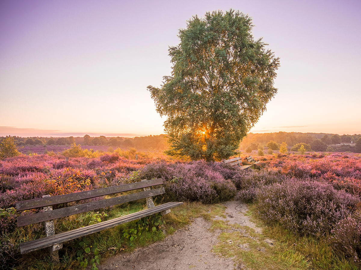
Postbank
The Posbank is a monumental bank (benches in the public space sometimes form a monument or memorial) and an adjacent tea house on the southern Veluwe near Rheden. The bank is at a height of 90 meters above NAP in the Veluwezoom National Park with a view over the IJsseldal, Arnhem, the Achterhoek and the Liemers as far as Germany. By way of comparison: the highest point on the Veluwe is the nearby Signal Imbosch (110 m). The tavern that used to be at the Posbank was destroyed in a fire in 1996. In 2002, Natuurmonumenten had a new tea house (Paviljoen de Posbank) built according to a sustainable design.
The Posbank was built in honor of the 25th anniversary of Mr GA Pos on 7 May 1918. Pos was the second chairman of the ANWB and one of the pioneers of the association. The Posbank is also popularly the name for the hilly heathland in which it is located, but this area is actually called the Herikhuizerveld.
Castle and Estate Middachten
With its 900 ha, Middachten is one of the largest private estates in the Veluwe. Middachten is first mentioned in 1190 as a free good of Jacobus de Mithdac. At the beginning of the 14th century Everardus van Steenre (1335-between 1392 and 1400) transferred the property (for protection) to Reinald Graaf van Gelre. Everardus subsequently received it in fief from the count in 1357. Everardus van Middachten is ancestor of all later lords and women of Middachten; until 1625 the castle remained in this family. The castle is thus of medieval origin, but was repeatedly destroyed and rebuilt in modified form. Around Castle Middachten you can enjoy centuries-old gardens, beautiful avenues, stately trees, undulating lawns and rose gardens.
Youth village De Glind
Youth village De Glind is a small, green village between Amersfoort, Leusden and Barneveld. In the village young people, who for reasons cannot grow up with their own parents, find (temporary) shelter. In De Glind you can enjoy walking, eating out, there is a petting zoo and a treasure island. We cordially invite you to visit us! Then come to the Grand Café Ons, where young people work on their future through a learning-work trajectory!


 Links
Links  Usage
Usage Want to download this route?
You can download the route for free without MyRoute-app account. To do so, open the route and click 'save as'. Want to edit this route?
No problem, start by opening the route. Follow the tutorial and create your personal MyRoute-app account. After registration, your trial starts automatically.  Disclaimer
Use of this GPS route is at your own expense and risk. The route has been carefully composed and checked by a MyRoute-app accredited RouteXpert for use on TomTom, Garmin and MyRoute-app Navigation.
Changes may nevertheless have occurred due to changed circumstances, road diversions or seasonal closures. We therefore recommend checking each route before use.
Preferably use the route track in your navigation system. More information about the use of MyRoute-app can be found on the website under 'Community' or 'Academy'.
De Hoge Veluwe National Park
About this region
De Hoge Veluwe National Park is a Dutch national park in the province of Gelderland near the cities of Ede, Wageningen, Arnhem and Apeldoorn. It is approximately 55 km2 (14,000 acres; 21 sq mi) in area, consisting of heathlands, sand dunes, and woodlands. It is situated in the Veluwe, the area of the largest terminal moraine in the Netherlands. Most of the landscape of the park and the Veluwe was created during the last Ice Age. The alternating sand dune areas and heathlands may have been caused by human utilization of the surrounding lands. The park forms one of the largest continuous nature reserves in the Netherlands.
Read more on Wikipedia
View region
 Statistics
  14
14Amount of RX reviews (De Hoge Veluwe National Park)
 36033
36033Amount of visitors (De Hoge Veluwe National Park)
 7480
7480Amount of downloads (De Hoge Veluwe National Park)
 Route Collections in this region
 The 10 most beautiful car and motorcycle routes in the Netherlands
These 10 routes in the Netherlands have been carefully selected, checked and made equal for TomTom, Garmin and MyRoute-app Navigation by a MyRoute-app RouteXpert. The 10 most beautiful motorcycle and car routes in the Netherlands are always a snapshot, and a personal opinion of the reviewer. This does not alter the fact that every lover of beautiful roads and interesting sights will enjoy these routes.
The ten routes are spread over 10 provinces, we only skipped Flevoland and South Holland. Interesting routes can also be found in the MyRoute app RouteXpert library, but we still want to stick to the 10 most beautiful and not the 12 most beautiful.
Enjoy the many fortresses and castles that are included in the routes, such as Fort Veldhuis in North Holland. But also take a look at the route southeast of Nijmegen and visit the impressive Canadian War Cemetery and Memorial. The route 'Overijssel in bird's eye view' includes the oldest house in the Netherlands and the route along the IJssel is probably the most beautiful piece of asphalt in the Netherlands.
This way there is something for everyone in this route collection. If you do not agree with these 10 routes, please send us an e-mail, indicate which route(s) should be removed and which route you would like to see instead. Maybe your route will be included in this collection of the 10 most beautiful routes in the Netherlands!
Email: info@myrouteapp.com
View Route Collection
The 10 most beautiful car and motorcycle routes in Gelderland
Gelderland, De Hoge Veluwe National Park, who doesn't know it? But not only this, Gelderland is the largest province in the Netherlands. The province is located in the middle and east of the Netherlands and is bordered in the northeast by Overijssel, in the east by the German state of North Rhine-Westphalia, in the south by Limburg and North Brabant, in the extreme southwest by South Holland, in the west by the province of Utrecht, in the northwest by the Veluwerandmeren, with Flevoland on the other side.
But not only the largest province of the Netherlands, Gelderland also has 'The Four Days Marches Nijmegen', officially the International Four Days Marches Nijmegen, this is a four-day walking event that has been held every year since 1909 and starts on the third Tuesday of July. It is the largest multi-day walking performance tour in the world and is now also known as The Walk of the World.
In the largest province of the Netherlands it is of course very nice to tour by car or motorcycle and to enjoy all the beauty that the province of Gelderland has to offer. For this, the MyRoute app RouteXpert has put together a Top 10 of Car and Motorcycle routes for you.
All routes in this collection have been checked and made equal for TomTom, Garmin and MyRoute-app Navigation by a MyRoute-app RouteXpert.
If you think, I have a very nice route that should certainly not be missing from this collection, send it to:
email: routeexpert@myrouteapp.com
Subject: New Route for the Top 10 collection Province of Gelderland compiled by Hans van de Ven.
The route will then be reviewed and then added to the Top 10. To make the Top 10 also the Top 10, 1 route will have to disappear from the Top 10, you can indicate this when submitting the new route.
Have fun with this collection and while driving one of these routes. Enjoy all the beauty that the Netherlands and in particular the province of Gelderland has to offer. Click on “View route” to read the review of the chosen route.
I would like to hear your findings about the route(s).
View Route Collection