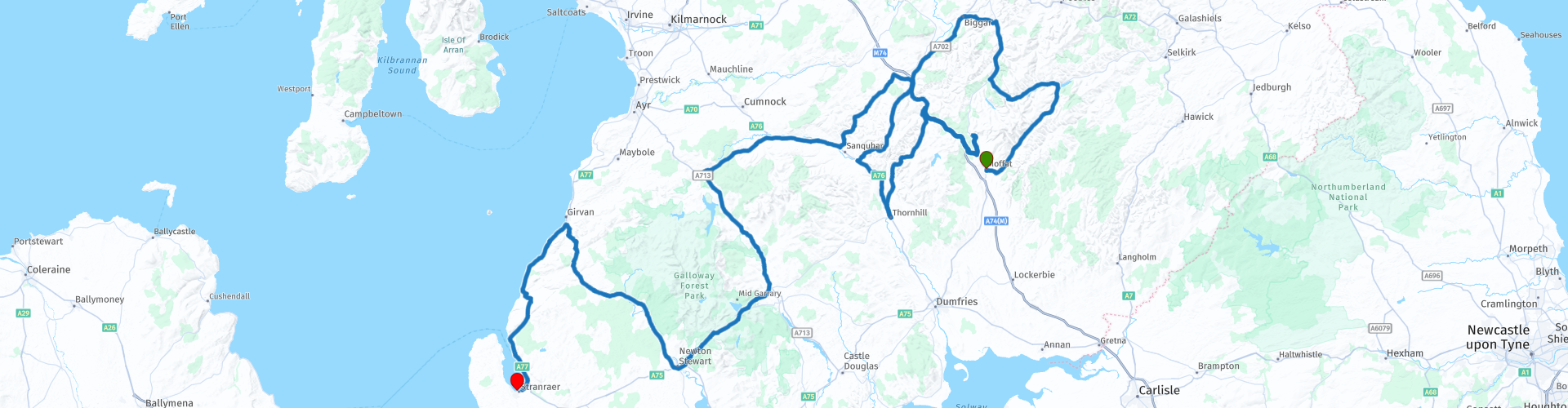
Moffat to Stranraer

This route was brought to you by:
RouteXpert Ian Street
Last edit: 01-12-2021
 Route Summary
 I have awarded this route 5 ***** stars. Lovely scenery, manageable roads and a chance to relax and enjoy the stunning views that this area of Scotland has to offer.
 Share this route


Animation

Verdict


Duration
9h 32m

Mode of travel
Car or motorcycle

Distance
366.38 km

Countries

 RouteXpert Review
 The start of the route takes you in a northeast direction along the A708 through some wide-open twisty roads up past Loch Skeen to Loch of the Lowes and St Marys Loch. Loch of the Lowes and St Marys Loch, the lay-by at the Glen café, is great for views of them both. You may be able to spot tame chaffinch, also swans, mallards, goldeneye, goosander, peregrine falcons, osprey and buzzards.
Turning off the main road we travel along a single-track road with plenty of passing places, but there is no rush as the flora and fauna that you may see as you pass two more reservoirs, in my view is worth it, along with being at the second highest point (1427ft) of this route.
The small layby at the Devils Beeftub which is a hollow that nestles between four hills whilst the Annan River flows through the valley floor. The landmark’s unusual name is derived from its use as the hiding place for cattle stolen by the notorious Border Reivers, otherwise known as the Johnstone clan, who were commonly referred to by their enemies as ‘devils’.
Now heading south towards Moffat before again turning north and following the A74(M). After snaking alongside the A74(M) for around 10 miles, we turn again and head in a southerly direction through some more wide-open twisty roads along the A702, dropping down to 232ft. Passing through Carronbridge to the village of Thornhill for a coffee stop, there are plenty of roadside parking areas before the roundabout and the Drumlanfig café. Thornhill lies at the junction of the A76 Dumfries to Kilmarnock and A702 New Galloway to Edinburgh roads in the mid-section of the beautiful Nith Valley in Dumfriesshire.
The centre of the village is formed by a Cross of local sandstone, topped by a lead figure of the winged horse Pegasus. The Pegasus figure is, itself, made of lead, mined in the nearby Lead Hills.
From our coffee stop, we head back towards Carronbridge and along the A76 to Mennock, it is here we turn off the main road yet again and this time onto the B797 and along through the Mennock Pass, this is the highest pass crossing the Lowther Hills through the Southern Uplands of Scotland. This is a narrow B road that is both rural and quiet, it is a mostly double track road. This road has some stunning wide-open dramatic landscapes and wild moorland views, whilst climbing to a height of 1531ft and the highest village in Scotland.
Wanlockhead village was called Winlocke until 1566, derived from the Gaelic Cuingealach (the narrow pass). Lead, zinc, copper and silver were mined nearby, as well as some of the world's purest gold at 22.8 carats, which was used to make the Scottish Crown. Early gold miners included Cornelius de Vos, George Bowes, and Bevis Bulmer. Wanlockhead became known as "God's treasure house" from the richness of its mineral resources. The village is also the home of the highest pub in Scotland, the Wanlockhead Inn which opened in 2003. Wanlockhead has a moist oceanic climate, with cool to chilly weather throughout the year, bordering on a subpolar climate. This town has cool summers and chilly winters with snowfalls. It is one of the coldest inhabited places in the United Kingdom.
Again, we see ourselves gently dropping in altitude from the chilly height of 1531ft through a vast expanse of open flowing roads nestled between stunning views for as far as the eye can see.
As we reach the road junction of the B740 and the A76, we have the chance to go off route and visit the remains of Sanquhar Castle, it is said that Sanquhar was one of the castles Mary Queen of Scots, sought refuge in after her defeat at Langside in May 1568 and it is from here she headed for Terregles Castle and made that fatal decision to sail from the Solway Firth into English territory.
From here we head to our lunch stop in the village of Dalmellington, Dalmellington is a pretty town in East Ayrshire on the banks of Much Water, about 16 miles east of Ayr. The town is set in beautiful and remote countryside, Dalmellington has been named a Conservation Area in recognition of the large number of historical buildings that give the town its unique character. The town is also in perfect location for the Scottish Dark Sky Observatory, where you can enjoy views of the sky without artificial light pollution.
Due to the direction of the road, you will only get a glance of Loch Doon, which is around 3 miles from our lunch stop in Dalmellington. The loch was dammed in 1935 for the generating of hydro-electricity. This is the largest inland loch in Southern Scotland, about 7 miles long. The water for the Hydro System leaves the loch from the east side, through a large pipeline out through the hill to just north of Casphairn village, it then flows down to other lochs with Hydro Power Stations between Casphairn and Dumfries.
Dropping down even further south we pass more freshwater lochs and reservoirs that make part of the Galloway Hydro Electric Scheme. All of these surround the Galloway Forest National Park.
With another chance to get off the bikes and stretch your legs, we come to Glen of the Bar, there is parking at this spot, and a specially created walkway that takes you out over the North Western tip of the gully, not for the faint hearted! the viewing platform which overhangs a steep sided wooded valley where, it is thought, ancient Gallovidians drove wild animals over the edge prior to butchering them for meat and hides.
Back on the bikes and on through more open twisty roads to the small town of Newton Stewart, a former burgh town in the historical county of Wigtownshire in Dumfries and Galloway. The town is on the River Cree with most of the town to the west of the river, it is sometimes referred to as the "Gateway to the Galloway Hills". The River Cree is the dominating feature of Newton Stewart. The Cree is spanned by an attractive bridge in the middle of the town where it is delightful to sit by the weir and watch the river flow, but is just out of view on this route.
From Newton Stewart, we again see ourselves heading north to Grivan along the mostly tree lined A714, again we have a mix of twisty and straight roads for our enjoyment and pleasure. Just short of Grivan, we join the A77 and our last scheduled coffee stop of the day at a seaside snack bar, there is plenty of parking and along with a few tables, you can enjoy a coffee while enjoying the sea air.
Girvan is a burgh and harbour town in Carrick, South Ayrshire, Scotland. Situated on the east coast of the Firth of Clyde. It lies some 21 miles south of Ayr and 29 miles north of Stranraer, which is the main ferry port from Scotland to Northern Ireland and the ending location for this trip. Just north of the town is Grangestone Industrial Estate, which hosts a William Grant & Sons distillery that opened in 1964. This distillery is a lowland grain whisky distillery, owned by William Grant & Sons, it is one of the largest facilities in Scotland in which whisky is made, Hendrick's Gin is also produced here. The distillery is known as one of the most energy efficient distilleries in Scotland. Also in the town is a Nestlé factory that manufactures chocolate which is transported down to York and used in the making of Kit Kat’s and Yorkie bars.
The final stretch of this journey sees us yet again heading in a southerly direction along the A77 coastal road, with the open views of the sea to our left and the rolling green hills to the right, it just sums up a stunning journey through the Dumfries and Galloway area.
At Ballantrae we head away from the coast for a short period before re-joining it at the mouth of Loch Ryan. The amount of freight traffic now increases due to the ferry ports at both Cairnryan and Stranraer to Larne in Ireland.
Our journey ends at the North West Castle Hotel, a mid-range hotel, there is safe parking for motorcycles and being next to the local police station, we never had any issues when we stayed here.
Starting point: Buccleuch Arms Hotel, Moffat.
End point: North West Castle Hotel, Stranraer.
There are three petrol stations on route, Moffat, (Start) – Burnton (132miles) – Stranraer (End of ride).
The total mileage for this ride is 227 miles, but can be cut shorter.
The total time is 9 ½ hrs, including all the stops. Stranraer


 Links
Links  Usage
Usage Want to download this route?
You can download the route for free without MyRoute-app account. To do so, open the route and click 'save as'. Want to edit this route?
No problem, start by opening the route. Follow the tutorial and create your personal MyRoute-app account. After registration, your trial starts automatically.  Disclaimer
Use of this GPS route is at your own expense and risk. The route has been carefully composed and checked by a MyRoute-app accredited RouteXpert for use on TomTom, Garmin and MyRoute-app Navigation.
Changes may nevertheless have occurred due to changed circumstances, road diversions or seasonal closures. We therefore recommend checking each route before use.
Preferably use the route track in your navigation system. More information about the use of MyRoute-app can be found on the website under 'Community' or 'Academy'.