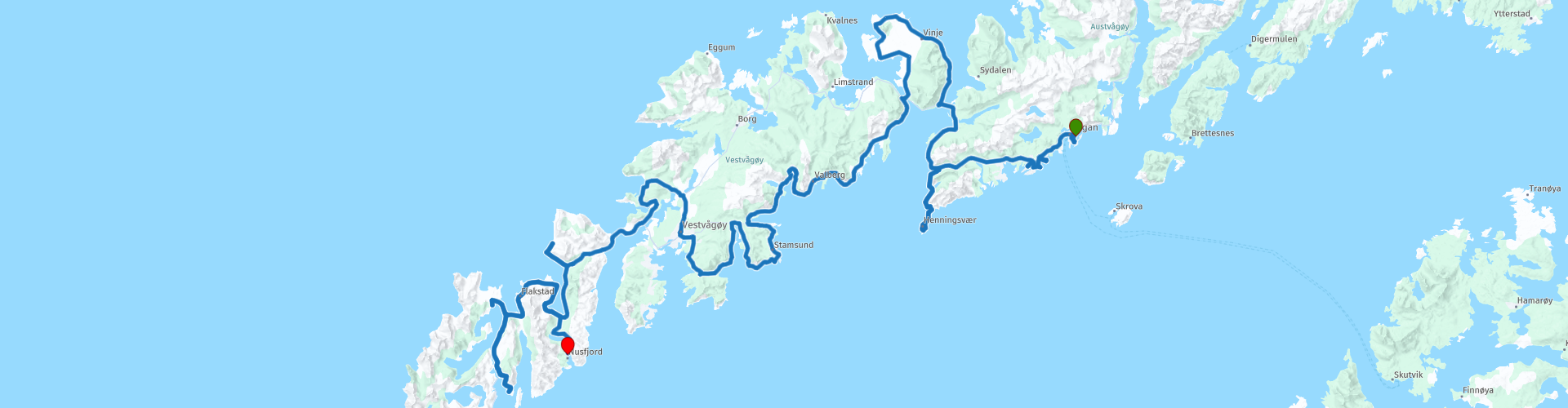
10 Svolvaer to Nussfjord

This route was brought to you by:
RouteXpert Leon Bodegom
Last edit: 08-02-2025
 Route Summary
 There is so much to discover and admire along the way. From picturesque villages to breathtaking views, every stop offers something unique. Be sure to check the opening hours of the attractions, as the tourist season is short and some places only open after Pentecost. But don’t let that discourage you, as the beauty of Lofoten is always present.
Use the hyperlinks in the review to check the current opening hours and get ready for a journey full of unforgettable moments. The Lofoten Islands are waiting for you, with their quiet roads and breathtaking landscapes. Go on an adventure and let yourself be enchanted by the magic of these beautiful islands.
I awarded the route with 5 stars because it is an endless drive on the winding roads across the island landscape. After every bend a different landscape, up and down bridges or you are suddenly at the end of the road waiting for a ferry service.
Start: Svolvær, Scandic Hotel Svolvær
End: Nusfjord, Nusfjord Arctic Hotel
 Share this route


Animation

Verdict


Duration
10h 2m

Mode of travel
Car or motorcycle

Distance
235.35 km

Countries

 RouteXpert Review
 The route also includes a number of museums. These are generally small-scale but always worth a visit. This can be combined with a coffee stop because there are few to no places on the route.
Opposite the hotel in Svolvær lies the Austvågøy peninsula with the coastal defence battery from bygone times. From the shore at the Hurtigruten landing stage you have a nice view of it.
At Kabelvåg there is a lot to see. Just before Kabelvag you will find a large historical wooden church on the left of the road. Driving through Kabelvag you have a view of fortifications that you can also visit. With a detour through and along Kabelvåg you will automatically pass by there. You will also find the Lofoten Museum and the Lofoten Aquarium there, which are not large but certainly worth a visit.
After 23 kilometers the route turns left up and down to Henningsvær. A small town, divided over islands and with a population of about 500 people. In high season many temporary residents more with all the tourists. After passing the various bridges you arrive in this beautiful fishing village. There is not much parking space, but with the motorbike you can always find a spot. Take the opportunity here for a short trip and a cup of coffee.
After the Gimsøystraumen bridge there is an option to shorten the route a bit by turning left after the bridge and following the E10 until over the Sundklakkstraumen bridge. According to the Michelin maps, these are all scenic roads and in many places it is worth stopping for a landscape photo. You can fill up on petrol again in Leknes. This is also a somewhat larger town where there is also a supermarket 'Lofotensenteret' on the route, with a motorbike parking next to the front door. Behind the supermarket you will find a shopping street with various catering establishments.
After this you will also come across several other options for overnight stays in cabins.
Both Lofoten cabins and Lofoten Hytter are beautiful places on the water for this.
After passing through the 1.8 km long Nappstraum tunnel you can make a detour to the right to a glassworks. The road ends here in the fishing village of Vikten and you will have to drive back a bit.
Before you drive to your final destination in Nusfjord, you may have some time to drive to Flekstad and/or Sund. At Flekstad you will find starting points for beautiful walks such as to Kvalvika Beach (Day trip). Or to Sund where a fishing and smithy museum is housed. Here also art sales of all kinds of wrought iron such as images of the birds that occur on the Lofoten.
After passing through the 1.8 km long Nappstraum tunnel you can make a detour to the right to a glassworks. The road ends here in the fishing village of Vikten and you will have to drive back a bit.
After this you reach the final destination Nusfjord. This was originally a fishing village, but was bought by an investor and transformed into a total museum/hotel facility. Original inhabitants still live there. The historical character had to remain and that has certainly succeeded.
A walk here is definitely worth it. From the harbour you can also make sea canoe trips.


 Links
Links  Usage
Usage Want to download this route?
You can download the route for free without MyRoute-app account. To do so, open the route and click 'save as'. Want to edit this route?
No problem, start by opening the route. Follow the tutorial and create your personal MyRoute-app account. After registration, your trial starts automatically.  Disclaimer
Use of this GPS route is at your own expense and risk. The route has been carefully composed and checked by a MyRoute-app accredited RouteXpert for use on TomTom, Garmin and MyRoute-app Navigation.
Changes may nevertheless have occurred due to changed circumstances, road diversions or seasonal closures. We therefore recommend checking each route before use.
Preferably use the route track in your navigation system. More information about the use of MyRoute-app can be found on the website under 'Community' or 'Academy'.

Nordland
About this region
Nordland (Norwegian pronunciation: [ˈnûːrlɑn] (listen); Lule Sami: Nordlánnda, Southern Sami: Nordlaante, Northern Sami: Nordlánda, English: Northland) is a county in Norway in the Northern Norway region, bordering Troms og Finnmark in the north, Trøndelag in the south, Norrbotten County in Sweden to the east, Västerbotten County to the southeast, and the Atlantic Ocean (Norwegian Sea) to the west. The county was formerly known as Nordlandene amt. The county administration is in the town of Bodø. The remote Arctic island of Jan Mayen has been administered from Nordland since 1995. In the southern part of the county is Vega, listed on the UNESCO World Heritage Site list.
Read more on Wikipedia
View region
 Statistics
  16
16Amount of RX reviews (Nordland)
 20942
20942Amount of visitors (Nordland)
 940
940Amount of downloads (Nordland)
 Route Collections in this region
 In 12 Days from Oslo to the North Cape
This is a route collection of a motorcycle tour from Oslo to the North Cape, based on a journey by Thomas Falck Østli. A total of twelve routes have been described, but the tour can be extended to more days, more information about this in the reviews.
The routes run through the beautiful landscapes of Norway, including the Lofoten, with many lakes, fjords, rivers, beautiful bridges, beautiful green forests and rugged mountains. During the trip there are also many ferry crossings, keep this in mind in your planning.
You drive longer distances in Norway without encountering a gas station or a restaurant, keep this in mind before you drive. Make sure your tank is full and bring food and drinks. Bring a few bottles of water or Camel bag and fill it up when you stop to refuel. Along the way, breaks are planned for refueling, eating and drinking.
The total trip of almost 3700 kilometers is broken down as follows;
• Day 1 is a 434 kilometer drive from Oslo to Geiranger
• Day 2 is a 238 kilometer drive from Geiranger to Kristiansund
• Day 3 is a 298 kilometer drive from Kristiansund via Trondheim to Verdal
• Day 4 is a 333 kilometer drive from Verdal to Brønnøysund
• Day 5 is a 267 kilometer drive from Brønnøysund to Furøy
• Day 6 is a 296 kilometer drive from Furøy Lofoten to Reine
• Day 7 is a 218 kilometer drive from Reine to Ørsvågvær
• Day 8 is a 274 kilometer drive from Ørsvågvær to Straumsjøen
• Day 9 is a 327 kilometer drive from Straumsjøen to Senjahopen
• Day 10 is a 321 kilometer drive from Senjahopen to Tromsø
• Day 11 is a 420 kilometer drive from Tromsø to Alta
• Day 12 is a 239 km drive from Alta via the North Cape to Skarsvåg
You have the choice to stay overnight at campsites or in hotels. Hotel prices in Norway are not particularly high and breakfast is usually included.
Camping is free almost everywhere, except on private property or where camping is prohibited, indicated by prohibition signs.
If you don't want to camp, there are often cabins for rent on the campsites. For a trip through Norway it is always advisable to bring a tent and other camping gear.
Information about hotels and campsites is included in the directions
Have fun reading, planning and driving this scenic journey to the northernmost tip of Europe.
View Route Collection
6500 kilometers through Scandinavia with the highlights of the Lofoten and the North Cape
The Arctic Challenge Tour, on which this 26-part tour is partly based, is not a speed race. It's a tour. It comes down to agility, good navigation and anticipation. The participants are obliged to adhere to the speed limit of the country concerned. The participants must find the ideal route with the shortest possible distance by complying 100% with the locally applicable traffic rules. Of course, also take maximum speeds into account. The organization checks for violations of the speed limit. In case of gross or repeated exceeding of the maximum speed, disqualification for the relevant stage and for the final classification will follow. Control of the route and speeds is done by means of a track and trace system. This equipment is installed in every vehicle. You can then follow each team accurately in the Back Office. Those staying at home, interested parties and participants can also see the performances of the teams, because you can be followed live via the Internet. The Back Office takes action when a team gets into trouble. (source: website The Arctic Challenge)
That's quite a luxury, having a back office behind you that keeps an eye on you. Most of us will not have that and are on our own or the fellow traveler(s). The only agreement you have with the participants is that you also have to abide by the rules. Fortunately, you don't have to complete this tour in 9 days, like the participants, but you can take it a little longer.
The highlight of the Arctic Challenge in 2020 was the Lofoten, an island group northwest of Norway. The Lofoten archipelago is located in the middle of the wild Norwegian Sea, well above the Arctic Circle. This special region offers a beautiful landscape with imposing mountains, deep fjords and long, wild sandy beaches where the sound of the seabird colonies can always be heard.
The archipelago is best known for its rich fishing tradition. The Lofoten makes a prosperous impression despite their isolated location. The entire economy revolves above all around fishing. The image of the Lofoten is mainly dominated by wooden racks with cod, which hangs to dry. Lofoten fishing has been a household name for centuries. In the middle of winter, the ships set out to catch the fish in just a few months. The rich fishing grounds are due to the North Atlantic Warm Gulf Stream around the islands, in which the fish have their spawning grounds. Oil drilling is not permitted around Lofoten and the cod spawning grounds there.
The next destination for the participants was Sirkka, also known as Levi, a winter sports resort in Finnish Lapland. They stayed there for a few days to go ice-karting and to enjoy the snow by going on a snowmobile or skiing trip. This tour also takes you to Sirkka, but instead of staying there for a few days, you have the option to continue to the North Cape, the second highlight of this trip.
Imagine a place in the far north, where the Atlantic Ocean meets the icy waters of the Arctic Ocean. This place is the North Cape in Western Finnmark in Northern Norway. From here, only the archipelago of Spitsbergen lies between you and the North Pole and the sun shines for 2.5 months at a time; from mid-May to the end of July. Many visitors admire the midnight sun or the sunset over the Barents Sea from the North Cape plateau.
With each route you will find a review with a description of the route, where you pass and what to see along the way. It is also briefly described how the participants in the Arctic Challenge in 2020 had to drive it anyway, from which point to which point. Along the way, markings (route points) have been included that indicate the end points of the stages that the participants had to complete. As mentioned, they covered the distance in 9 days, stages of more than 1000 kilometers were no exception.
Each route ends at a hotel. It is of course not an obligation to use these hotels, you can always find another place to stay in the area, that decision is up to you. My experience, however, is that they are all simple but good hotels for a very reasonable price. They are known and can be booked at booking.com.
The routes of these collections:
R01 - Puttgarden to Angelholm, 280km
R02 - Angelholm to Alingsas, 281km
R03 - Alingsas to Mysen, 261km
R04 - Mysen to Rena, 312km
R05 - Rena to Orkanger, 306km
R06 - Orkanger to Grong, 292km
R07 - Grong to Mo i Rana, 290km
R08 - Mo i Rana to Bodo, 231km
R09 - Roundtour Bodo to Lofoten part 1, 314km
R10 - Roundtour Bodo to Lofoten part 2, 250km
R11 - Roundtour Bodo to Lofoten part 3, 291km
R12 - Bodo to Arjeplog, 295km
R13 - Arjeplog to Jokkmokk, 244km
R14 - Jokkmokk to Pajala, 239km
R15 - Roundtour Sirkka to North Cape part 1, 257km
R16 - Roundtour Sirkka to North Cape part 2, 300km
R17 - Roundtour Sirkka to North Cape part 3, 244km
R18 - Roundtour Sirkka to North Cape part 4, 275km
R19 - Roundtour Sirkka to North Cape part 5, 332km
R20 - Sirkka to Kemi, 299km
R21 - Kemi to Ylivieska, 251km
R22 - Ylivieska to Jalasjarvi, 236km
R23 - Jalasjarvi to Turku, 279km
R24 - Stockholm to Askersund, 271km
R25 - Askersund to Varnamo, 224
R26 - Varnamo to Trelleborg, 259km
Have fun driving these routes!
View Route Collection