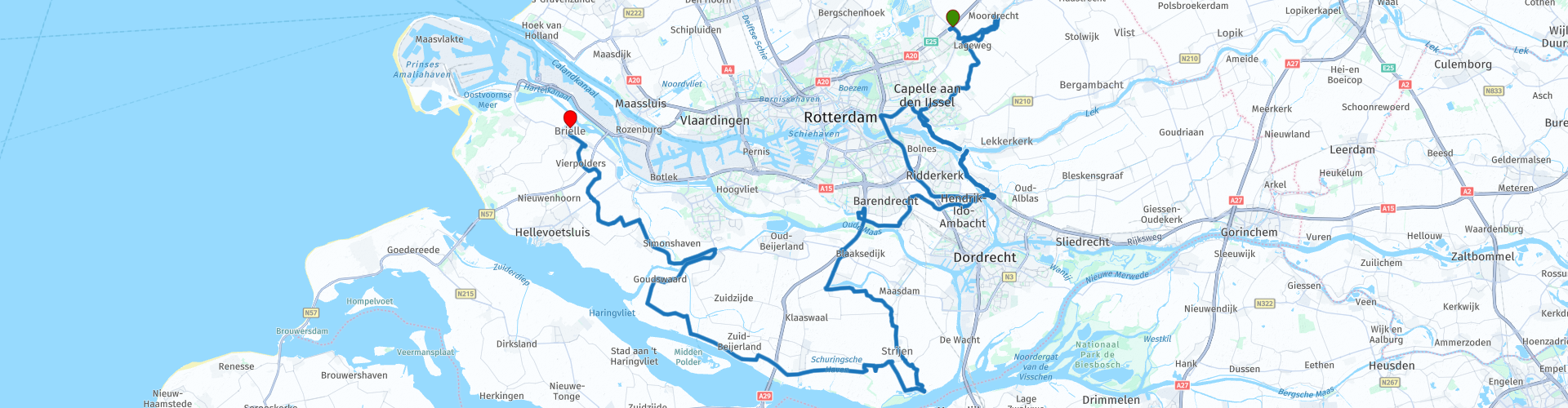
Nieuwerkerk aan den IJssel Brielle over de Hoeksche Waard en Voorne Putten

This route was brought to you by:
RouteXpert Dick Schaap
Last edit: 23-02-2022
 Route Summary
 This route (driven in 2021) is on beautiful and easily accessible dike roads through polder landscape. This route deserves more than 4 stars.
In this route a ferry is taken 3 times. Bring some coins.
Start: Hotel van der Valk, Parallelweg Zuid 185, 2914 LE Nieuwerkerk aan den IJssel
Lunch: Het Schippershuis Molendijk 2, 3281 LT Numansdorp
End of route: Eetcafé Dixie, Maasland Zuidzijde 1-3, 3231 CJ Brielle
 Share this route


Animation

Verdict


Duration
6h 27m

Mode of travel
Car or motorcycle

Distance
134.71 km

Countries

 RouteXpert Review
 After the crossing, a visit to the Unesco viewpoint Kinderdijk (world heritage). Kinderdijk was protected against the water by 2 x 8 mills (1738 - 1740) of 2 boards, Overwaard and Nederwaard. Now there are 19 windmills divided into a row of eight windmills on the Nederwaard (these are the round stone mills), a row of eight thatched octagons on the Overwaard, with a seesaw mill next to it; the Blokweerse mill that drains the Blokweer polder and two thatched octagonal mills in the Nieuw-Lekkerland polder. in 1886 Kinderdijk was the first Dutch town with an electricity supply. There are various stories about the name Kinderdijk.
The best-known story about the origin of the name Kinderdijk goes back to 1421 during the great St. Elisabeth flood. When the worst storm had passed, people went up the dike to see what could be saved and in the distance a cradle was seen drifting. They had no hope that there would be anything alive in it, but when it came closer they saw movement. When it got even closer, a cat was seen balancing the crib by bouncing back and forth so that no water could get into the crib. When the cradle was finally close to the dike, it was fished up. It turned out that there was still a baby in it, who slept soundly and dryly.
After Kinderdijk, the route descends along the tidal river De Noord until past Alblasserdam. There the route takes the bridge over De Noord to Hendrik Ido Ambacht. Hendrik IA is not that special, however, the name is because it was once the longest place name in Europe. Until 1855 the municipality was called Hendrik-Ido-Schildmanskinderen-Ambacht en de Oostendam. The merger with Sandelingen-Ambacht in that year resulted in the current name of the municipality, which is also the name of the only village within the municipal boundaries. The municipality was once called Hendrik Ido Oostendam and Schildmanskinderen Ambacht, and perhaps once Hendrik-Ido-Oostendam-Schildmanskinderen-Groot-and-Klein-Sandelingen-Ambacht, this would have been the longest place name in all of Europe.
After Hendrik IA, the Waal is followed. This Waal (called Waaltje), not to be confused with the great Waal, is a dead river arm of De Noord. In the early Middle Ages (this) the Waal was a wide river and formed a connection between the Noord and the Oude Maas. At the crossing of the Waaltje there is a beautiful view of the Kersenboom windmill from 1822.
Via the Heinoordtunnel (under the Oude Maas) it goes to the island of Hoeksche Waard and over dike roads past the town of Mijnsheerenland and the Oudeland van Strijen to the Hollandsch Diep. Hollandsch Diep (also: Hollands Diep) is a wide tidal river that forms the main lower reaches of the (large) Waal and the Maas. There used to be a tidal difference of 2 meters. After the Delta Works, the difference is still 20 cm. The water of this stream has always been completely fresh, as a result of the very large discharge of the Rhine and (to a lesser extent) the Meuse.
The route continues on dike roads past the villages of Numansdorp, Nieuwendijk, Goudswaard to Nieuw-Beijerland.
Nieuwendijk is a hamlet of a few streets with 350 inhabitants. In the flood disaster of 1953 a large part of Nieuwendijk was heavily damaged. Norway came to the rescue with 36 Norwegian homes. Before the disaster, almost all homes were on the dike. Later the new houses were built in the polder. Hence the street names are named after Norwegian celebrities and Norwegian place names. From the Benedenhaven in Nieuwendijk the ferry goes over the "Hitsersche- or Vuile Gat" to the island of Tiengemeten.
The name of the island of Tiengemeten indicates its size: a gemet is an old measure of land measuring over 0.4 hectares. Tiengemeten is 7 km long and 2 km wide. The size of the island and the name are therefore no longer in agreement: 10 measured is approximately 4 hectares, which means: a piece of 100 by 400 meters. The island was originally largely leased to farmers. Since 1997 it has been managed by Natuurmonumenten as a wet nature reserve. The Rien Poortvliet and an Agricultural Museum are located on Tiengemeten.
In Goudswaard the route passes Korenmolen Windlust. This ground sailor, on the Molendijk, is a national monument. According to the gable stone in the hull, the stone mill would date from 1694, making it one of the oldest surviving stone mills in the Netherlands, but that is doubted. Windlust milled until 1945, after which it fell into disrepair. During a restoration in 1962, a large part of the mill collapsed and the millmaker was buried under the rubble, from which he recovered. Today the mill is once again capable of grinding and grain is ground. In the mill there are two grinding couples, a mixing kettle, an elevator and a towing hatch.
In Nieuw-Beijerland the ferry, “The Queen Jacqueline”, is taken to make the crossing from the Spui to the island of Putten. Before the ferry is taken, the route passes corn mill De Swaen.
De Swaen, formerly called Windlust, is a windmill built in 1703. It is a round stone flour mill of the ground sailor type with a thatched roof. Today, the mill is only used as a reception center, because the interior has been almost completely demolished. Only the upper shaft with the upper wheel is still present in the mill.
After the ferry, the route goes along the Spui to the town of Zuidland. Zuidland, in the regional dialect Sland, appears to be an insignificant town with 6000 inhabitants and 2250 homes. Zuytlant (old spelling) never became an important place and never received city rights. Still, a visit is worthwhile because the town is home to the beautiful Korenmolen De Arend (a stone mill from 1844) and has no fewer than 27 entries in the national monument register and has a beautiful inner harbour.
Documents mention the 'Heerlickheit Westenrijck' for the first time at the end of the 13th century, to which the street name Westenrijk still refers in Zuidland. In the Middle Ages, the names Blinc- or Blenkvliet and Couwenhoven were also used for the village.
After Zuidland it is 15 km over dike roads to Brielle (Den Briel), the end point of this route. Who has never heard of Brielle? Den Briel is located on the Brielse Meer, a dammed up part of the Maas. Brielle, in the Middle Ages the fifth largest city in the region of Holland, is an old fortified town and the most famous pilgrimage site in South Holland. The fortress of Brielle, which dates largely from the 17th century, is a national monument and one of the best-preserved defenses in the Netherlands. The name goes back to the Celtic word 'brogilo' ('enclosed area, hunting ground') and from the oldest writings it appears that the current location is 'the new Briel'.
On April 1, 1572, the city was taken by the Watergeuzen led by Lumey and Bloys van Treslong, in which the ferryman Jan Koppestok played an important role. The capture of Den Briel is generally seen as the actual beginning of the revolt against Philip II (Eighty Years' War). To this fact Brielle owes her shield motto Libertatis Primitiae, "firstfruits of freedom". This historical fact is celebrated every year on April 1. School children remember this fact with the sentence:
"On April 1, Alva lost his glasses" (actually: "On April 1, Alva lost Den Briel")
Before Brielle, the route passes the Catharinahoeve, a monumental farm. According to a gable stone, the farm was built in 1805. The first stone was laid by Hugo Touw. In the house there is a 19th century tile tableau depicting castles, fishermen, ice skaters and agriculture. On October 11, 1966, the farm was registered as a national monument.
The end point of the route is at Café Dixie, Maasland ZZ 1-3, 3231 CJ Brielle.


 Links
Links  Usage
Usage Want to download this route?
You can download the route for free without MyRoute-app account. To do so, open the route and click 'save as'. Want to edit this route?
No problem, start by opening the route. Follow the tutorial and create your personal MyRoute-app account. After registration, your trial starts automatically.  Disclaimer
Use of this GPS route is at your own expense and risk. The route has been carefully composed and checked by a MyRoute-app accredited RouteXpert for use on TomTom, Garmin and MyRoute-app Navigation.
Changes may nevertheless have occurred due to changed circumstances, road diversions or seasonal closures. We therefore recommend checking each route before use.
Preferably use the route track in your navigation system. More information about the use of MyRoute-app can be found on the website under 'Community' or 'Academy'.