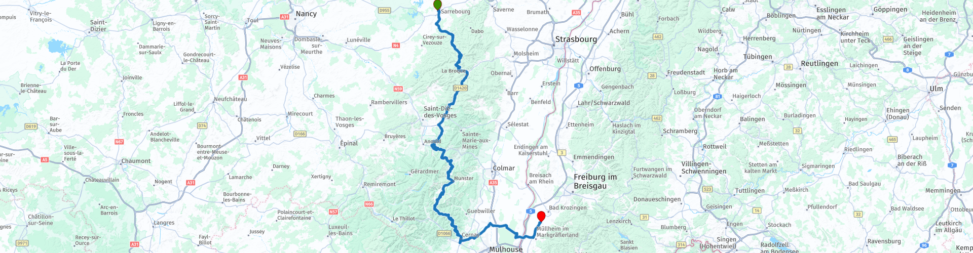
D2 Sarrebourg to Heitersheim

This route was brought to you by:
RouteXpert Albert van den Elsen-RX
Last edit: 14-09-2023
 Route Summary
 How could it be otherwise than that this route once again deserves 5 stars.
If you are a novice motorcyclist, you can indulge yourself and gain a lot of experience riding the many winding roads in these mountain areas, but do not take too many risks.
As we always say “Safety First”.
 Share this route


Animation

Verdict


Duration
7h 22m

Mode of travel
Car or motorcycle

Distance
242.19 km

Countries


 RouteXpert Review
 Alsace, known as Elsace and 'Grand Est', is a region that has passed back and forth between France and Germany, and exudes a unique charm.
Hesse and Abresviller, the first pearls of this journey, lie along the picturesque banks of the river "La Sarre Rouge". These villages seemed straight out of a fairy tale, with their colorful half-timbered houses and small windows that radiated a warm glow.
The real mountain adventures start at the "Rocher du Diable", the devil's rock, which towers above everything at 430 meters high. The road, called the 'Route des Vin d'Alsace', leads you further through the mountains, where every kilometer brings you closer to the clouds. The route south is known as the Route des Vins d'Alsace, or the wine route. This originally 170 kilometer long road winds through the medium-high mountain landscape of Alsace, from Station du Lac to the charming town of Munster.
Along the winding roads and with the river "La Sarre Rouge" at your side, you finally reach Munster. Here, at the crossroads of history and nature, you begin following the "Route des Crêtes" or Ridge Route, which once served as a supply route for French troops during the First World War. You will soon notice that the mountains become more and more impressive during the ride.
After driving 28 kilometers on winding roads, you reach the 'Tête de Malcôte' at an altitude of 800 meters, where the first small mountain pass, the 'Col de la Côte de l'Engin', unfolds before you. During most of the route you follow the erratic course of the river 'La Sarre Rouge', a tributary of the Sarre, which originates 35 kilometers away at Mont Donon, the highest peak of the northern Vosges. Then you descend south through the Vosges. Passing lush vineyards where Riesling, Pinot Blanc and Gewürztraminer have their roots, you feel the breath of nature in every bend. Here, in this privileged corner of France, the landscape whispered its stories to the wind.
A little later the Vosges mountains loom on the horizon. The trees become denser, the views more spectacular, and the heights begin to rise.
Your lunch stop is planned at the enchanting hotel-restaurant "Les Terrasses du Lac Blanc" in Orbey, where you will overlook the ski slopes of Lac Blanc, perched between 1200 and 1130 meters above sea level. The panoramic view of the glittering lake "Lac Blanc" is like a painting that comes to life, like a moment where time seems to stand still.
This area is part of the regional park "des Ballons des Vosges", a refuge of natural splendor and serenity. The Route des Crêtes leads you from Col du Bonhomme to the Grand Ballon, the highest peak in the Vosges at 1424 metres. Here, on top of the world, embrace the surrounding beauty with every breath and click of your camera.
As you descend from the Grand Ballon through the Vosges, the roads become winding again and the views more breathtaking through the lush forests and the vineyards that produced the noblest grapes.
Then you drive on to the Haut-Rhin department in the enchanting Grand Est region, where picturesque Cernay with its historic old town, beautiful half-timbered houses, narrow streets and atmospheric squares, together with its thriving textile industry, will captivate you with its beauty.
This is also the place of your last coffee stops at MC Donalds.
Slowly but surely you approach the border of Germany, a country that always seems to be within reach. The places are given German names, as a reminder of a history in which boundaries have often shifted. The origin of these names can be traced back to the time when the region around Mullhouse was in German hands from 1871 to 1918 (peace of Frankfurt) and from 1940 to 1945.
Eventually you reach your final destination, Heitersheim, just across the German border. Just a quick fuel stop and then the OX Hotel welcomes you with open arms, a haven of comfort and hospitality after a day full of adventure.
As you watch the sun set over the German hills, you will know that this journey through Alsace and the Vosges has become a chapter in your own story, a memory you would cherish forever.


 Links
Links  Usage
Usage Want to download this route?
You can download the route for free without MyRoute-app account. To do so, open the route and click 'save as'. Want to edit this route?
No problem, start by opening the route. Follow the tutorial and create your personal MyRoute-app account. After registration, your trial starts automatically.  Disclaimer
Use of this GPS route is at your own expense and risk. The route has been carefully composed and checked by a MyRoute-app accredited RouteXpert for use on TomTom, Garmin and MyRoute-app Navigation.
Changes may nevertheless have occurred due to changed circumstances, road diversions or seasonal closures. We therefore recommend checking each route before use.
Preferably use the route track in your navigation system. More information about the use of MyRoute-app can be found on the website under 'Community' or 'Academy'.

Baden-Württemberg
About this region
Baden-Württemberg (; German: [ˌbaːdn̩ ˈvʏʁtəmbɛʁk] (listen)), commonly shortened to BW or BaWü, is a German state (Bundesland) in Southwest Germany, east of the Rhine, which forms the southern part of Germany's western border with France. With more than 11.07 million inhabitants as of 2019 across a total area of nearly 35,752 km2 (13,804 sq mi), it is the third-largest German state by both area (behind Bavaria and Lower Saxony) and population (behind North Rhine-Westphalia and Bavaria). As a federated state, Baden-Württemberg is a partly-sovereign parliamentary republic. The largest city in Baden-Württemberg is the state capital of Stuttgart, followed by Mannheim and Karlsruhe. Other major cities are Freiburg im Breisgau, Heidelberg, Heilbronn, Pforzheim, Reutlingen, Tübingen, and Ulm.
What is now Baden-Württemberg was formerly the historical territories of Baden, Prussian Hohenzollern, and Württemberg. Baden-Württemberg became a state of West Germany in April 1952 by the merger of Württemberg-Baden, South Baden, and Württemberg-Hohenzollern. These states had just been artificially created by the Allies after World War II out of the existing traditional states Baden and Württemberg by their separation over different occupation zones.
Baden-Württemberg is especially known for its strong economy with various industries like car manufacturing, electrical engineering, mechanical engineering, the service sector, and more. It has the third highest gross regional product (GRP) in Germany. Part of the Four Motors for Europe, some of the largest German companies are headquartered in Baden-Württemberg, including Daimler, Porsche, Bosch and SAP.
The sobriquet Ländle (a diminutive of the word "Land" in the local Swabian, Alemannic and Franconian dialects) is sometimes used as a synonym for Baden-Württemberg.
Read more on Wikipedia
What is now Baden-Württemberg was formerly the historical territories of Baden, Prussian Hohenzollern, and Württemberg. Baden-Württemberg became a state of West Germany in April 1952 by the merger of Württemberg-Baden, South Baden, and Württemberg-Hohenzollern. These states had just been artificially created by the Allies after World War II out of the existing traditional states Baden and Württemberg by their separation over different occupation zones.
Baden-Württemberg is especially known for its strong economy with various industries like car manufacturing, electrical engineering, mechanical engineering, the service sector, and more. It has the third highest gross regional product (GRP) in Germany. Part of the Four Motors for Europe, some of the largest German companies are headquartered in Baden-Württemberg, including Daimler, Porsche, Bosch and SAP.
The sobriquet Ländle (a diminutive of the word "Land" in the local Swabian, Alemannic and Franconian dialects) is sometimes used as a synonym for Baden-Württemberg.
View region
 Statistics
  61
61Amount of RX reviews (Baden-Württemberg)
 51843
51843Amount of visitors (Baden-Württemberg)
 11188
11188Amount of downloads (Baden-Württemberg)
 Route Collections in this region
 Top 5 Car and Motorcycle Routes in the Black Forest
The Black Forest, who hasn't heard of it? The Black Forest is a densely forested area and low mountain range in southwestern Germany, located in the state of Baden-Württemberg, on the Rhine and the French border. It is the largest low mountain range in Germany. Geologically, it is related to the Vosges Mountains, which lie on the French side of the Rhine. The highest peak of the Black Forest is the Feldberg with a height of 1493 meters above sea level. The Black Forest is the largest forest area in Germany and consists mainly of pine and spruce trees. The Black Forest is known as one of the most popular tourist destinations in Germany. A small part in the north is protected as the Schwarzwald National Park. The Romans called the densely forested mountain range with its distinctive dark conifers Silva Nigra - "the Black or Dark Forest or impenetrable forest", which to them was ominous and almost impenetrable. The German word Schwarzwald was used for the first time in a document from the Swiss monastery of St. Gallen from the year 868. A well-known car route is the Schwarzwald-Hochstraße, B 500 and the Uhrenstraße. The Black Forest is known worldwide for the fairy tales of the Brothers Grimm.
There are also several lakes in the Black Forest, namely: Titisee, Glaswaldsee, Mummelsee, Kirnbergsee, Feldsee, Schluchsee and the Hotzenwald.
The highest peaks in the Black Forest are: Feldberg (1493 m), Seebuck (1448 m), Herzogenhorn (1415 m), Belchen (1414 m), Schauinsland (1284 m), Kandel (1243 m) and the Hornisgrinde (1164 m ).
Reason enough for the MyRoute app RouteXpert to compile a Top 5 of Car and Motorcycle Routes for you.
All routes in this collection have been checked and made equal for TomTom, Garmin and MyRoute-app Navigation by a MyRoute-app RouteXpert.
If you think, I have a very nice route that should certainly not be missing from this collection, send it to:
email: routeexpert@myrouteapp.com
Subject: New Route for the Top 5 collection Black Forest composed by Hans van de Ven.
The route will then be reviewed and then added to the Top 5. To make the Top 5 also the Top 5, 1 route will have to disappear from the Top 5, you can indicate this when submitting the new route.
Have fun with this collection and while driving one of these routes. Enjoy all the beauty that the Black Forest has to offer. Click on “View route” to read the review of the chosen route.
I would like to hear your findings about the route(s).
View Route Collection
11 day trip from the Netherlands
8 countries in 11 days; The Netherlands, Germany, Austria, Italy, Switzerland, France, Luxembourg and Belgium. This route collections consists of 10 routes that I have driven with friends in the summer of 2019.
The start is in Geldermalsen Netherlands, the first 7 days you drive through the Netherlands, Germany, Austria, Italy, Switzerland, France and a piece of Luxembourg with overnight stays in hotels.
The last three days you stay in Barweiler (D) in the Eifel and you drive two beautiful tours through the Eifel, Luxembourg and parts of the Belgian Ardennes.
There is no highway in the routes, only beautiful provincial and country roads, many beautiful passes with beautiful panoramas.
Be sure to check whether the passes are open before you leave.
These are routes for experienced drivers.
View Route Collection