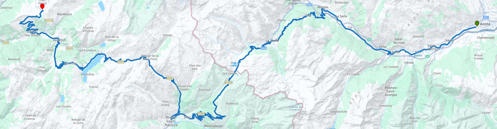
02 Tour von Aosta via kl Bernhard nach Beaufort und Les Saisies

This route was brought to you by:
RouteXpert David Ruprecht
Last edit: 17-11-2023
 Route Summary
 The impressive mountains, varied nature and winding pass roads often invite you to stop and linger for photos.
A route that is so varied, exciting and promising in terms of driving, simply deserves five stars.
Despite the many winding mountain roads, this tour is easy to master even for beginners with appropriately adapted driving skills.
 Share this route


Animation

Verdict


Duration
7h 21m

Mode of travel
Car or motorcycle

Distance
151.96 km

Countries


 RouteXpert Review
 A route that is so varied, exciting and promising in terms of driving, simply deserves five stars.
Despite the many winding mountain roads, this tour is easy to master even for beginners with appropriately adapted driving skills.
As early risers, we enjoyed breakfast in one of the countless small cafés in the old town of Aosta and experienced how the picturesque town slowly comes to life. There was also enough time for a short shopping tour before we got on the motorbikes. First the path takes us along the main road up the valley towards the Mont Blanc Tunnel. We forego the motorway and enjoy the road along the villages.
The Rochefort chapel above Leverogne beamed at us from afar. We spontaneously turned off and took the short, steep hairpin bends up to the hamlet of Rochefort, where we were able to park the bikes in the parking lot on the left. We walked through narrow, ancient and beautifully renovated houses up to the little church. This short excursion is worth taking a different route on the way back to the parking lot. The picturesque facades seem to come from another century.
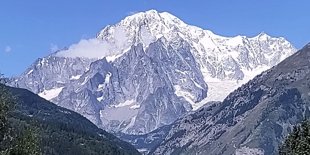
First you go down the same way as up, as the journey continues into a beautiful high valley, but it is a dead end. Be careful, after the last hairpin bend in the village you take a sharp left, almost a 180 degree turn. Back on the main road, Mont-Blanc with its wide, white back continues to wink at us in the distance. Of course we make a quick photo stop to capture this before we turn left in Morgex and climb the Colle San Carlos. What a fantastic pass. Diverse stretches of road, mostly in the forest, are simply wonderfully refreshing and soothing in summer. At the top of the pass there is a beautiful restaurant, La Genzianella, for a coffee.
Since we arrived there late at noon on a sunny Sunday, we had no chance of getting a seat in the restaurant. So it's worth getting there early enough or, even better, going on a weekday. The popularity of this pass is reflected in the number of cars parked left and right around the top of the pass for several kilometers. So we drove on without stopping for coffee.
After the valley floor of La Thuile, the famous tourist town is worth visiting, we go up the small St. Bernhard. The mountains tower impressively to the left and right of the road and halfway up the mountain restaurant Lo Riondet is ideal for a delicious snack. The view there is enormous and the food is fine and relatively cheap.
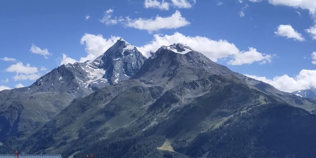
Strengthened, we climb the second half up to 2,188 meters above sea level and, once at the top, enjoy the view of the lake, mountains and valleys. The old customs station and tank defenses are also impressive, but they are all out of service. Curvy and with at least one stop to take photos of the wonderful view, the route descends to Séez. There we join the official route of the Routes des Grandes Alpes. If you have ten to fourteen days to spare, you should definitely go on this tour. I will soon put this tour online, but of course there are already some route suggestions for it.
We follow the official route over the Cormet de Roselend and down to Lac de Roselend. On the pass we fortify ourselves with drinks at a stand and enjoy the mountains before we head down to the azure lake. Curves between cow pastures lead us to this uniquely picturesque lake, where we stop at least once to take photos. Instead of the very beautiful, official route, which goes off to the right at the Col du Méraillet, we only turn right about two kilometers later and also cross the small, fine Col du Pré. The serpentines towards the end are a little more challenging, but with so little traffic and such a beautiful view, you're happy to take it on.
Today we just drive through Beaufort, a very picturesque medieval town, and a few kilometers later we ignore the signpost for the Tour des Grandes Alpes towards Saisies. We first drive to Villard-Sur-Doron and climb up the serpentines and curves of side roads to the Mont Bisanne reserve. Until a few years ago, you could still drive up to the mountain station by motorcycle, but unfortunately this access has now been banned. You then go down to Les Saisies via holiday colonies on the south side of the famous ski area. We highly recommend the Hotel Le Very, it offers cheap, rustic and comfortably furnished rooms and a good breakfast buffet. For dinner there are various restaurants in the area. If you're not Swiss like us and only consume fondue in Switzerland, we recommend a fondue evening.
 Links
Links  Usage
Usage Want to download this route?
You can download the route for free without MyRoute-app account. To do so, open the route and click 'save as'. Want to edit this route?
No problem, start by opening the route. Follow the tutorial and create your personal MyRoute-app account. After registration, your trial starts automatically.  Disclaimer
Use of this GPS route is at your own expense and risk. The route has been carefully composed and checked by a MyRoute-app accredited RouteXpert for use on TomTom, Garmin and MyRoute-app Navigation.
Changes may nevertheless have occurred due to changed circumstances, road diversions or seasonal closures. We therefore recommend checking each route before use.
Preferably use the route track in your navigation system. More information about the use of MyRoute-app can be found on the website under 'Community' or 'Academy'.

Valle d Aosta
About this region
The Aosta Valley (Italian: Valle d'Aosta [ˈvalle daˈɔsta] (official) or Val d'Aosta (usual); French: Vallée d'Aoste; Arpitan: Val d'Outa; Walser: Augschtalann or Ougstalland; Piedmontese: Val d'Osta) is a mountainous autonomous region in northwestern Italy. It is bordered by Auvergne-Rhône-Alpes, France, to the west, Valais, Switzerland, to the north, and by Piedmont, Italy, to the south and east. The regional capital is Aosta.
Covering an area of 3,263 km2 (1,260 sq mi) and with a population of about 128,000 it is the smallest, least populous, and least densely populated region of Italy. The province of Aosta having been dissolved in 1945, the Aosta Valley region was the first region of Italy to abolish provincial subdivisions. Provincial administrative functions are provided by the regional government. The region is divided into 74 comuni (French: communes).
Italian and French are the official languages, though the native population also speak Valdôtain, a dialect of Franco-Provençal. Italian is spoken as a mother tongue by 77.29% of population, Valdôtain by 17.91%, and French by 1.25%. In 2009, reportedly 50.53% of the population could speak all three languages.
Read more on Wikipedia
Covering an area of 3,263 km2 (1,260 sq mi) and with a population of about 128,000 it is the smallest, least populous, and least densely populated region of Italy. The province of Aosta having been dissolved in 1945, the Aosta Valley region was the first region of Italy to abolish provincial subdivisions. Provincial administrative functions are provided by the regional government. The region is divided into 74 comuni (French: communes).
Italian and French are the official languages, though the native population also speak Valdôtain, a dialect of Franco-Provençal. Italian is spoken as a mother tongue by 77.29% of population, Valdôtain by 17.91%, and French by 1.25%. In 2009, reportedly 50.53% of the population could speak all three languages.
View region
 Statistics
  6
6Amount of RX reviews (Valle d Aosta)
 14128
14128Amount of visitors (Valle d Aosta)
 201
201Amount of downloads (Valle d Aosta)
 Route Collections in this region
 Tour around Switzerland
The Alps, a mountain range in Europe that stretches from the French Mediterranean coast in the southwest to the Pannonian plain in the east, almost always guarantee beautiful routes. It can hardly be boring there. The many passes, vistas and variations in the landscape make the Alps a true motorcycle paradise.
Switzerland is centrally located in this paradise and is surrounded on all sides by countries with beautiful steering on fantastic roads.
The 7 routes of this collection lead you around Switzerland, of course this beautiful country is also visited. You pass through beautiful areas such as the Alps, the French and Swiss Jura and the Black Forest.
A few sights are discussed in the review for each route. These often tell something about the history of the area in which you drive. So instructive. Many places are also marked where you can find some entertainment, for example a toboggan run. You are completely free to visit these sights, you can of course also determine your own points of interest.
But the main thing you probably traveled to this area for is simply driving. And as mentioned above, you are in a true motorcycle paradise where the steering is fantastic!
Each route ends at a hotel (except the last one which ends at the train station in Innsbruck). It is of course not an obligation to use these hotels, you can always find another place to stay in the area, that is entirely up to you. My experience, however, is that they are all simple but good hotels for a very reasonable price. They are known and can be booked through booking.com.
The routes of these collections:
R01 - Innsbruck to Chiuro, 301km
R02 - Chiuro to Brig, 279km
R03 - Brig to Bourg Saint Maurice, 288km
R04 - Bourg St Maurice to St Etienne de Cuines, 307km
R05 - St Etienne de Cuines to Metabief, 295km
R06 - Metabief to Fuerstenberg, 305km
R07 - Fuerstenberg to Innsbruck, 335km
Have fun driving these routes!
View Route Collection