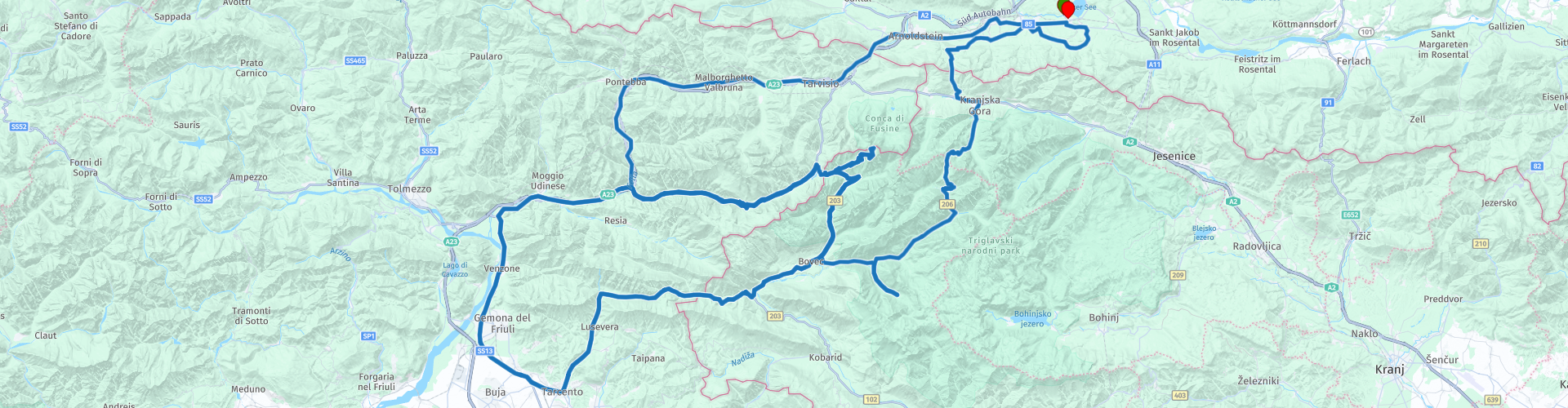
Roundtrip Faak am See via Bovec and Kranjska Gora

This route was brought to you by:
RouteXpert Albert van den Elsen
Last edit: 24-02-2024
 Route Summary
 This tour will make your holiday unforgettable, with plenty of opportunity to enjoy nature. Discover the beautiful natural phenomena along the route and be amazed by the diversity that this journey has to offer.
Consider, for example, the Mangart Saddle, the gorges on the Soca river, the 50 hairpin bends over the Vrsic pass and the Wurzenpass on the border between Slovenia and Austria.
Are you a diehard nature lover who likes to take the camera in hand during your holiday? Then this tour is really something for you.
Once you have completed this tour, you will undoubtedly understand why I had no choice but to award this tour with five stars.
For a novice rider it can be exciting because during your trip your agility will be tested somewhat by some steep climbs and various narrow roads.
You have to take this into account, a visit to the Mangart Saddle is not free.
But for €5 it is worth it to climb this climb. The pass is open from June to September.
 Share this route


Animation

Verdict


Duration
7h 55m

Mode of travel
Car or motorcycle

Distance
170.54 km

Countries


 RouteXpert Review
 I have enriched this route, which I have driven before, with extra special places that you should absolutely not miss in this enchanting environment. This route is definitely recommended because the focus is on breathtaking viewpoints.
But let's go for a ride. Just outside Faak am See you will see the Harley monument looming in the middle of the roundabout, which is also your last photo opportunity before you end this tour.
As soon as you turn right at the roundabout and head west, you immediately notice that the traffic calms down.
Via the characteristic Austrian towns of Finkenstein am Faaker See, Fürnitz and Arnoldstein, you drive through the 'Austrian Riviera', the area in the southernmost part of the Carnic Alps that owes its name to its Mediterranean climate and the attractive atmosphere that is comparable with that of the Italian Riviera.
Not long after you pass through this area you will come into view of Italy. Caccau Valico is where Italy greets you.
If you search for this location on Google Streetview, you will notice that another border crossing is shown. So don't let these photos influence you here.
Via this border crossing you follow the contours of the Italian Alps, through the beautiful valley 'Val Canale' to the 'Lago del Predel' where you have a view of high and imposing mountains along the way. Some of them even reach above 3000m.
Once you have left the 'Lago del Predel' behind you, you will follow a few hairpin bends and enter Serbia via the 'Predil Pass'. A pass that, thanks to its strategic location in Roman times, was an important point on the trade route between Rome and the north.
The Italian Alps also give way to the Julian Alps. This mountain area is named after Julius Caesar, who conquered the area 49 years BC. conquered. Today the Julian Alps are a major attraction for many tourists and offer opportunities for hiking, skiing, motorcycling and climbing.
A few kilometers further on you will cross Fort Predel, located at an altitude of 1156 meters. Crossing may sound strange, but that is because the fort is located on both the left and right of the road and you get the impression that you are driving through the fort.
Fort Predel was one of six Carinthian fortresses and dates back to the time of Napoleon. Later, this fort was destroyed several times during wars, and was always restored to the same place. For a long time it served as a military base and storage depot, but since 1994 the fort has been a museum dedicated to the time of the First World War.
After about 1 km you turn left towards your first beautiful sight: the 'Mangart Saddle'.
This attraction is located on the border between Slovenia and Italy. Geographically, it is located in the middle of the mountain ranges of the Karawanks and the Julian Alps.
The Mangart saddle or Mangart Pass is a mountain pass that takes you to an altitude of 2679 meters. This pass was built in 1938 by the Italians. This mountain pass consists of a single-lane road that leads you up and down. In addition, this mountain pass has many hairpin bends. So keep your speed because the abyss is very deep. But before you can climb the road to the top, you have to buy a ticket.
Once at the top you can enjoy many panoramic views towards Slovenia and Italy.
This is a place where you can unleash your inner photographer and take beautiful photos..
Here you will find beautiful landscapes full of life, with an abundance of plants and animals that together create a perfect picture.
If you drive down the same road again, you can look forward to the next stop where a well-deserved cup of coffee is waiting for you. But before that happens, follow the road past Koritnica, which flows through the beautiful Soča valley.
The Koritnica River rises in the Julian Alps and flows through a picturesque landscape of mountains and forests before joining the Soča River. The views from the road are a real feast for the eyes.
Just above Bovec you turn off at the town of 'Kal Koritnica' and partly follow the 138 km long Soca river, known for its crystal clear and turquoise water. At 'Pri Kumercih' you start your 25km journey towards your coffee stop at 'Dom Dr. Klementa Juga'. This mountain hut is popular as a simple restaurant, rest area and stopping place for hikers and mountain climbers.
This location owes its name to a famous Slovenian mountaineer and writer named Dr. Kelent Juga. This lodge long served as a military facility but was converted to its current state in 1985. Here too, the views of the surrounding area are a feast for the eyes and a suitable place to pick up your camera again. If you want to explore even more of the area, you could also consider a walk to the source of the nearby Lepenjica River.
After your coffee stop, you drive back down the same road towards the Soča River. At the T-junction around the corner it is time to park your vehicle and enjoy the serene beauty of the 'Velika Korita Soče' (Great Soča Gorge) gorge, known for its spectacular cliffs. This landmark attracts hikers and other tourists from all over the world.
The gorge was created because over time the Soča River, which has its origins in the Triglav National Park, has carved out a 14 km long gorge through erosion in the rocks. At some points the spectacular cliffs are up to 200 meters deep. The steep walls are covered with trees, plants and flowers. Clearly, this gorge is one of the many famous sights that Slovenia has to offer. Right next to the gorge you can take a walk along hiking trails where you can't miss taking a photo along the water.
I have to make a small comment here! Roadside parking near the gorge is limited and narrow. So drive carefully and be alert!
After this visit, you will follow the Soča River to the village of Trenta, where you will start the 21 kilometer long road with 50 hairpin bends over the Vršič Pass towards Kranjska Gora. This road was built long ago by Russian prisoners of war and stretches from Kranjska Gora to the Soča Valley. Each bend is numbered and the numbering starts at Kranjska Gora and ends at Trenta. That is why you will find bend number 50 on the signs at Trenta.
Along the way you will be treated to the most beautiful views of the mountains of the Slovenian Alps. The spectacular climb culminates at the Vršič Pass, but to get there you first have to climb 26 hairpin bends. This pass is the third sight of today.
Upon arrival at the Vršič Pass there will be a combined stop, where you will not only enjoy your lunch, but also visit the Vršič Pass viewpoint.
Your lunch stop is planned at the nearby restaurant 'Tičarjev dom', which offers a limited menu of simple, yet tasty dishes prepared with fresh local ingredients.
Have you finished eating? Then take the time to explore the area and walk to the viewpoint where the mountains offer you a breathtaking view. At the viewpoint you also have the chance to buy a nice souvenir of this place in the souvenir shop.
You will notice that the Alpine marmot is very popular here because of the wide range in the store. Alpine marmots live here in burrows and are common on this Vršič pass. Just take a good look around, you might see some! Once again, it is advisable to have your camera ready.
After the lunch stop you drive via 24 downward hairpin bends towards Kranjska Gora. But first, after a few hundred meters you arrive at the Vršič Pass. Unlike the hairpin bends on the way to the top, these 24 downward bends are all paved with bricks. This is because pavers offer more grip than asphalt, especially in wet and winter conditions.
Just before hairpin bend 8 you will find a Russian Chapel, located in a place that you would normally drive past because this chapel is somewhat hidden in the forest. This chapel was built in 1916 in memory of the Russian prisoners of war who died during the construction of the pass during the First World War.
The chapel is a simple stone building with a wooden roof, equipped with a small altar and a number of icons of Russian saints. Around the chapel is a small cemetery where the Russian prisoners of war are buried. Due to its beautiful location and unique history, this place is a popular tourist destination. It is recommended to park your vehicle in the adjacent parking lot and walk to the chapel
Then you drive through the last hairpin bends, after which you finally arrive in Kranjska Gora. Once you arrive at the bottom, take the third exit at the roundabout and continue to the fuel stop, which is located along the main road just outside the village. Here you can refuel for your next ride.
From here it is only a short distance before you arrive at your penultimate stop: the Wurzenpass. This pass is located at an altitude of 1073 meters in the Karawanken mountain area and forms the connection between Radendorf and Kranjska Gora. Drive calmly here, because unlike Western European countries, customs checks are still carried out here. From the Wurzenpass it only goes downhill and there are no more major climbs.
Once you arrive at the bottom, the first part of the route leads you to Riegersdorf, after which you turn towards Techantsing. Then you make another loop via Alt-Finkenstein and then come into view of the Harley Monument again.
The monument in Finkenstein was designed and built by Roman Oman, a Slovenian sculptor and architect. It was unveiled in 2013 in honor of the 110th anniversary of the Harley-Davidson Motor Company. It is a unique and striking work of art, made of steel and glass, in the shape of a Harley-Davidson motorcycle, is 12 meters high and weighs 12 tons.
For many, it is a must to have your photo taken with this monument. That is why some extra time has been planned for you to take advantage of this opportunity.
Then follows the last part of the route. Turn right again and then pass under the railway.
I have some additional information for the avid motorcyclists.
If you go to this area in early September, you can enjoy an abundance of motorcycles, as Harley Davidson hosts the annual European Bike Week here. This event is the fourth largest Harley event in the world and lasts almost a week.
In addition to being popular among motorcyclists, it is also a lucrative time for the catering industry, where a lot of money is made.
During European Bike Week there is a one-way traffic rule on the ring road around Lake Faakersee. So you cannot turn left at the T-junction to your final destination. That is why I have come up with an alternative route for you, so that you can still drive back to the guest house via a short route.
Oh yes, if you plan to eat out, I want to let you know that there are several restaurants within walking distance of the guest house where you can get a good meal. From my own experience I can recommend Popolari and Kärntnerhof. On both occasions you can enjoy different dishes from the local cuisine, and it is always pleasant. Because of the crowds, it is wise to book in advance.


 Links
Links  Usage
Usage Want to download this route?
You can download the route for free without MyRoute-app account. To do so, open the route and click 'save as'. Want to edit this route?
No problem, start by opening the route. Follow the tutorial and create your personal MyRoute-app account. After registration, your trial starts automatically.  Disclaimer
Use of this GPS route is at your own expense and risk. The route has been carefully composed and checked by a MyRoute-app accredited RouteXpert for use on TomTom, Garmin and MyRoute-app Navigation.
Changes may nevertheless have occurred due to changed circumstances, road diversions or seasonal closures. We therefore recommend checking each route before use.
Preferably use the route track in your navigation system. More information about the use of MyRoute-app can be found on the website under 'Community' or 'Academy'.

Carinthia
About this region
Carinthia (German: Kärnten [ˈkɛʁntn̩] (listen); Slovene: Koroška [kɔˈɾóːʃka] (listen)) is the southernmost Austrian state or Land. Situated within the Eastern Alps, it is noted for its mountains and lakes. The main language is German. Its regional dialects belong to the Southern Bavarian group. Carinthian Slovene dialects, forms of a South Slavic language that predominated in the southeastern part of the region up to the first half of the 20th century, are now spoken by a small minority in the area.
Carinthia's main industries are tourism, electronics, engineering, forestry, and agriculture. The multinational corporations Philips, Infineon Technologies and Siemens have large operations there.
Read more on Wikipedia
Carinthia's main industries are tourism, electronics, engineering, forestry, and agriculture. The multinational corporations Philips, Infineon Technologies and Siemens have large operations there.
View region
 Statistics
  35
35Amount of RX reviews (Carinthia)
 36782
36782Amount of visitors (Carinthia)
 5007
5007Amount of downloads (Carinthia)
 Route Collections in this region
 The 24 Most Beautiful Alpine Routes
The Alps, The Alps are a mountain range in Europe, stretching from the French Mediterranean coast in the southwest to the Pannonian Plain in the east. The area of the mountain range is more than 200,000 km².
In other words Passes and Mountain Roads!
Driving through the mountains is great! Especially over the mountain passes with hairpin bends and narrow winding roads. Every bend a different view where you can enjoy. There are many beautiful mountain passes in the Alps.
A selection that has also been incorporated into these routes:
The Stlevio Pass:
The Stelvio Pass, also known as Passo dello Stelvio, is mainly known for the stage in the Giro d'Italia. Due to the length and the difference in height, this pass is seen as one of the toughest tests in cycling. The Stelvio Pass reaches a maximum height of 2758 meters and is therefore one of the highest in the Alps. The pass connects the towns of Bormio and Prato Allo Stelvio. In winter the pass is closed due to heavy snowfall.
The Reschenpass:
The Reschenpass, also known as Passo di Resia, connects the Austrian state of Tyrol with the Italian province of South Tyrol. The pass reaches a maximum height of 1,504 meters and has been one of the most important north-south connections in the Alps in recent centuries. The pass was used long before Roman times. Along the way you will pass several highlights and historical relics. One of the highlights is the Reschensee. This lake was created after the construction of the dam and has completely submerged the village of Graun. The only thing that reminds of that is the clock tower in the middle of the lake.
Col du Galibier:
The French mountain pass Col du Galibier connects the towns of Saint-Michel-de-Maurienne and Briançon via the Col du Lautaret in the south and the Col du Télégraphe in the north. The mountain pass is part of the Tour de France and very much feared, due to the fact that it can only be reached via the other two mountain passes. The pass reaches a maximum height of 2646 meters. From there you can take a walk to the viewpoint at 2704 meters. You can admire the peaks of the Grand Galibier, Mont Blanc and La Meije here.
The Grossglockner High Alpine Road:
With a height of 3798 meters the Grossglockner is the highest mountain in Austria. To fully enjoy this impressive mountain, you can drive over the Grossglockner High Alpine Road and the accompanying pass. The route starts from Bruck am Grossglockner and ends in Heiligenblut. Of course you can drive in two directions. The pass reaches a maximum height of 2504 meters and is closed in winter due to heavy snowfall. Along the way you pass several stops with fun activities, information points, mountain huts and viewpoints. A visit to the Kaiser-Franz-Josefs-Höhe and Pasterzen Glacier is highly recommended.
The Col d'Izoard:
Just like the Col du Galibier, the Col d'Izoard is also part of a stage of the Tour de France. The mountain pass connects Briançon with the valley of the river Guil. The pass is partly located in the Regional Natural Park du Queyras and reaches a maximum height of 2360 meters. What is special about the Col d'Izoard is the barren and rocky landscape. Sometimes it feels like driving a car over the moon! Along the way you can stop at several points to enjoy the beautiful view.
The Bernina Pass:
The Bernina Express is one of the most famous rail trains in Switzerland and the Alps. The route is beautiful and partly included on the UNESCO World Heritage List. Parallel to the railway lies the Bernina pass, which connects the Veltlin valley with the Egandin valley. This beautiful Alpine road has a total length of 56 kilometers and reaches a maximum height of 2328 meters. Along the way you can enjoy views of the Morteratsch Glacier.
The Sella Pass:
The Sella Pass, also known as Passo di Sella, takes you over one of the most impressive mountain ranges in the Dolomites: the Sella massif. The pass connects Valle di Fassa with Val Gardena and reaches a maximum height of 2236 meters. At this height is also the border of the Italian provinces of Trentino and Bolzano. Along the way you can enjoy the view of this spectacular mountain world. Admire, for example, the three peaks of the Sasso Lungo massif, the Sella massif or the peaks of the Marmolada. You can also drive the Sella pass in combination with the Gardena pass, Pordoi pass and Campolongo pass.
The Grimsel Pass:
The Grimsel Pass connects Goms in Wallis with the Halis Valley in the Bernese Oberland. The pass reaches a maximum elevation of 2165 meters and is closed in winter due to snowfall. Over the centuries, the mountain pass has played an important role in trade between Switzerland and Italy. Now it is mainly the reservoirs that have an important function. These are used to generate electricity. The landscape you drive through is rugged, rocky and impressive. On top of the pass is a hotel and a restaurant with a special marmot park. The Dodensee (Totensee) is also located here. This lake owes its name to the many soldiers who died in the time of Napoleon.
The Gotthard Pass:
The Gotthard Pass, also known as Passo del San Gottardo and Saint Gotthard, connects the Swiss towns of Airolo and Andermatt. The mountain pass and associated tunnel are especially known among holidaymakers driving from Switzerland to Italy. But where the majority opt for the tunnel, it is precisely the pass that really completes the holiday. The Gotthard Pass has a length of about 26 kilometers and reaches a maximum height of 2106 meters. The route is beautiful and takes you along old villages and beautiful views.
The Silvretta High Alpine Road and Silvretta Pass:
The Paznaun Valley in Tyrol and the Montafon in Vorarlberg are connected by the Silvretta High Alpine Road. The route has a length of 22.3 kilometers and leads from Galtür to Partenen in 34 hairpin bends, via the 2032 meter high Bielerhöhe. The Silvrettasee is also located at this point, where you can enjoy a lovely walk. The pass is closed in winter due to snowfall.
The Simplon Pass:
Just like the Gotthard Pass, many holidaymakers also travel over the Simplon Pass every year. This mountain pass connects the Rhone Valley in the canton of Valais with the Valle d'Ossola in Piemonte. The pass is open all year round and reaches a maximum height of 2005 meters. Along the way you pass a number of buildings, including the well-known Simplon Hospiz from 1825. The hospiz is managed by the monks of St. Bernard. From the highest point on the pass, all kinds of hiking routes are possible and you will also come across a hotel where you can spend the night.
The Gerlos Pass:
The Gerlos Pass connects the Salzach Valley in the Salzburgerland with the Zillertal Valley in Tyrol. The pass is part of the Gerlos Alpenstraße and runs right through the Hohe Tauern National Park. Along the way you can enjoy beautiful views of the surroundings. The pass has a length of 12 kilometers and reaches a maximum height of 1531 meters. A ride over the Gerlos Pass can be ideally combined with a visit to the Krimmler Wasserfälle.
The Great St. Bernard Pass:
The Great St. Bernard Pass, better known as Col du Grand Saint Bernard, connects the Italian province of Valle d'Aosta with the Swiss canton of Valais. The pass is one of the highest in Switzerland and reaches a maximum height of 2469 meters. Like a number of other mountain passes in this list, the Great St. Bernard Pass has also been used as a connecting road for centuries. The pass is named after the St. Bernard dogs that used to help stranded travelers along with the monks. The pass is closed in winter.
The Timmelsjoch High Alpine Road:
The Timmelsjoch High Alpine Road connects the towns of Sölden in the Ötztal and Meran in South Tyrol. Tolls must be paid on the Hochgurgl - Moos route. Via a mountain road with about 60 hairpin bends you drive through a beautiful mountain world. With the Timmelsjoch Experience you can learn more about the history, the road and the environment via various stations. You can also visit the Top Mountain Crosspoint museum.
Col de l'Iseran:
With a maximum pass height of 2770 meters, the Col l'Iséran is one of the highest mountain passes in the Alps. The pass connects Bourg-Saint-Maurice with Bonneval-sur-Arc. Via a road full of hairpin bends you pass, among other things, Val-d'Isère and a side valley of the Maurienne that lies entirely in the National Park de la Vanoise. You can spot animals such as marmots and chamois and there is also a restaurant with a chapel on top of the pass.
The Gavia Pass:
The Gavia Pass (Italian Passo di Gavia) is a mountain pass in the Italian Alps, in the Lombardy region.
It is one of the highest pass roads in Europe. The road leads through the unspoilt Stelvio National Park. The road was built in the First World War to supply Italian soldiers who fought in the Italian-Austrian border area. The pass height is one of the most beautiful in the Alps. Here is the large Lago Bianco with, to the north, the mountain San Matteo (3684 meters). Lago Nero is slightly lower on the south side of the pass. Here the mountain group of the Adamello determines the view. There are many well-marked walks in the area. During the winter the pass is closed due to the heavy snowfall. The pass is often closed until May and June due to the large amount of snow.
Promoter has made a selection of the 24 Most Beautiful Alpine routes that they have set out in recent years.
The routes go through:
France
Austria
Switzerland
Italy
The most beautiful roads, the most beautiful views, the most beautiful viewpoints. The highest mountains, the fastest descents, hairpin bend after hairpin bend, you name it you can't get enough of it.
If you go on holiday in this region, take advantage of it, ALL routes in this collection have been checked and made equal for TomTom, Garmin and MyRoute-app Navigation by a MyRoute-app RouteXpert.
Have fun with this collection and while driving one of these routes. Enjoy all the beauty that the Alps and the Dolomites have to offer. Click on “View route” to read the review of the chosen route.
I would like to hear your findings about the route(s).
View Route Collection
The 12 most beautiful car and motorcycle routes in Carinthia
“Motorradland Kärnten” where you feel so wonderfully welcome as a motorcyclist!
Own website for motorcyclists, own curated routes, hotels, campsites and guest houses with attention for motorcyclists, a wonderful area where motorcyclists are very popular.
Kärnten or Carinthia, at the crossroads of the Germanic, Slavic and Roman worlds. Three cultures within a few kilometres, southern flair, culinary delights, cross-border tours. Breakfast in Italy, lunch in Slovenia, dinner in Austria - all in one day. Experience the diversity in the borderless Alps-Adriatic region, the area for motorcyclists.
Extensive day trips on winding mountain paths, romantic panoramic routes and beautiful lakes, here the 12 TOP routes Kärnten / Carinthia. Enjoy!
View Route Collection