04 Lincoln Highway Ligonier PA to Hanoverton OH

This route was brought to you by:
RouteXpert Paul Hedges - Adv RouteXpert
Last edit: 06-11-2025
 Route Summary
  Share this route


Animation

Verdict


Duration
8h 18m

Mode of travel
Car or motorcycle

Distance
191.22 km

Countries

 RouteXpert Review
 The Lincoln Highway was America's first national memorial to President Abraham Lincoln, predating the 1922 dedication of the Lincoln Memorial in Washington, D.C., by nine years. As the first automobile road across America, the Lincoln Highway brought great prosperity to the hundreds of cities, towns and villages along the way. The Lincoln Highway became affectionately known as "The Main Street Across America".
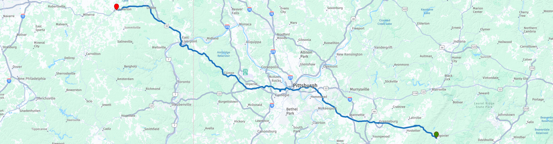
Day 4 of 19: Ligonier PA to Hanoverton OH. Forts, Diners, Inclines, and Inns – From Ligonier to Ohio
Start each day with a full tank of fuel and a sense of curiosity.
The day begins with a journey back in time at Fort Ligonier, a reconstructed 18th-century fort that played a key role in the French and Indian War. The museum’s exhibits and restored fortifications offer a vivid look at colonial military history. Remarkably, during its eight years as a garrison, Fort Ligonier was never taken by an enemy.
Admission: $18 (Adult, Nov 2025)
Hours: 10 AM – 5 PM (check website for seasonal variations)
Just down the road is the Lincoln Highway Experience, the largest museum in America dedicated to the story of the first coast-to-coast highway.
Admission: $15 (Nov 2025), includes:
Use of individual audio wands
A Lincoln Highway postcard (with postage if written on-site)
A slice of pie and a cup of coffee or tea inside the restored 1938 Serro’s Diner
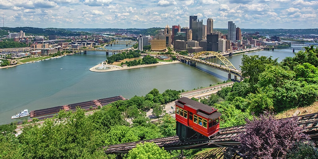
Continuing west on Route 30, the journey brings you to Pittsburgh, where roadside murals continue to celebrate the Lincoln Highway’s legacy. While in the city, take time to ride the historic Duquesne Incline, built in 1877 to transport cargo—and later passengers—up and down Mt. Washington.
Ride Details:
Length: 800 feet (244 m)
Elevation: 400 feet (122 m)
Fare: $5 round trip (Adult, Nov 2025)
At the top, enjoy panoramic views of the Pittsburgh skyline across the Ohio River.
Leaving Pennsylvania behind, the route crosses into West Virginia, passing over the Wayne Six Toll Bridge.
Toll: $1 (Nov 2025)
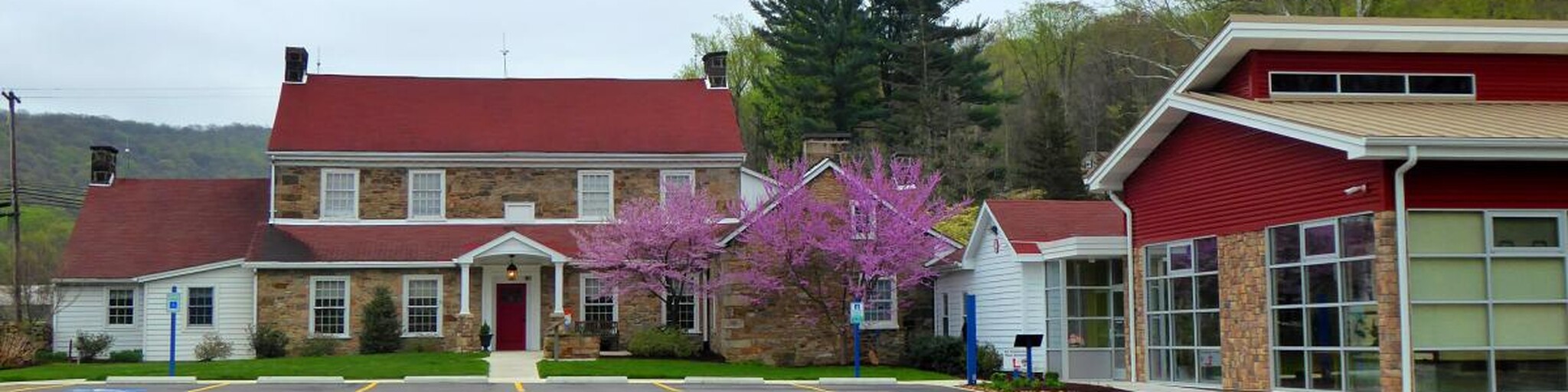
Shortly after, you enter Ohio, where the day ends at the charming Spread Eagle Tavern & Inn. This historic inn offers rooms decorated with period antiques and outfitted with modern conveniences, providing a cozy and atmospheric overnight stay.
Another varied historical 4 star day that has delived history, new and old and taken us further along the traveling adventure which is the Lincoln Highway
 Links
Links  Usage
Usage Want to download this route?
You can download the route for free without MyRoute-app account. To do so, open the route and click 'save as'. Want to edit this route?
No problem, start by opening the route. Follow the tutorial and create your personal MyRoute-app account. After registration, your trial starts automatically.  Disclaimer
Use of this GPS route is at your own expense and risk. The route has been carefully composed and checked by a MyRoute-app accredited RouteXpert for use on TomTom, Garmin and MyRoute-app Navigation.
Changes may nevertheless have occurred due to changed circumstances, road diversions or seasonal closures. We therefore recommend checking each route before use.
Preferably use the route track in your navigation system. More information about the use of MyRoute-app can be found on the website under 'Community' or 'Academy'.

West Virginia
About this region
West Virginia is a state in the Appalachian, Mid-Atlantic and Southeastern regions of the United States. It is bordered by Pennsylvania to the northeast, Maryland to the east and northeast, Virginia to the southeast, Kentucky to the southwest, and Ohio to the northwest. West Virginia is the 41st-largest state by area and ranks 40th in population, with a population of 1,793,716 residents. The capital and largest city is Charleston.
West Virginia became a state after the Wheeling Conventions of 1861, at the start of the American Civil War. Delegates from northwestern Virginia's Unionist counties decided to break away from Virginia, which also included secessionist counties in the new state. West Virginia was admitted to the Union on June 20, 1863, and was a key border state during the war. It was the only state to form by separating from a Confederate state, the second to separate from a state after Maine separated from Massachusetts, and one of two states (along with Nevada) admitted to the Union during the Civil War. Some of its residents held slaves, but most were yeoman farmers, and the delegates provided for the gradual abolition of slavery in the new state constitution. The state legislature abolished slavery in the state, and at the same time ratified the 13th Amendment abolishing slavery nationally on February 3, 1865.
West Virginia's Northern Panhandle extends adjacent to Pennsylvania and Ohio to form a tristate area, with Wheeling and Weirton just across the border from the Pittsburgh metropolitan area. Huntington in the southwest is close to Ohio and Kentucky, while Martinsburg and Harpers Ferry in the Eastern Panhandle region are considered part of the Washington metropolitan area, between Maryland and Virginia. West Virginia is often included in several U.S. geographical regions, including the Mid-Atlantic, the Upland South, and the Southeastern United States. It is the only state entirely within the area served by the Appalachian Regional Commission; the area is commonly defined as "Appalachia".The state is noted for its mountains and rolling hills, its historically significant coal mining and logging industries, and its political and labor history. It is also known for a wide range of outdoor recreational opportunities, including skiing, whitewater rafting, fishing, hiking, backpacking, mountain biking, rock climbing, and hunting.
Other nominated names for the state included Vandalia, Kanawha, Appalachia, and Western Virginia. The capital was originally Wheeling, before switching to Charleston, moving back to Wheeling, and finally back to Charleston. While it is now a solidly Republican state, it was Democratic from the Franklin D. Roosevelt era to the 1990s. The first governor was Arthur Boreman.
Read more on Wikipedia
West Virginia became a state after the Wheeling Conventions of 1861, at the start of the American Civil War. Delegates from northwestern Virginia's Unionist counties decided to break away from Virginia, which also included secessionist counties in the new state. West Virginia was admitted to the Union on June 20, 1863, and was a key border state during the war. It was the only state to form by separating from a Confederate state, the second to separate from a state after Maine separated from Massachusetts, and one of two states (along with Nevada) admitted to the Union during the Civil War. Some of its residents held slaves, but most were yeoman farmers, and the delegates provided for the gradual abolition of slavery in the new state constitution. The state legislature abolished slavery in the state, and at the same time ratified the 13th Amendment abolishing slavery nationally on February 3, 1865.
West Virginia's Northern Panhandle extends adjacent to Pennsylvania and Ohio to form a tristate area, with Wheeling and Weirton just across the border from the Pittsburgh metropolitan area. Huntington in the southwest is close to Ohio and Kentucky, while Martinsburg and Harpers Ferry in the Eastern Panhandle region are considered part of the Washington metropolitan area, between Maryland and Virginia. West Virginia is often included in several U.S. geographical regions, including the Mid-Atlantic, the Upland South, and the Southeastern United States. It is the only state entirely within the area served by the Appalachian Regional Commission; the area is commonly defined as "Appalachia".The state is noted for its mountains and rolling hills, its historically significant coal mining and logging industries, and its political and labor history. It is also known for a wide range of outdoor recreational opportunities, including skiing, whitewater rafting, fishing, hiking, backpacking, mountain biking, rock climbing, and hunting.
Other nominated names for the state included Vandalia, Kanawha, Appalachia, and Western Virginia. The capital was originally Wheeling, before switching to Charleston, moving back to Wheeling, and finally back to Charleston. While it is now a solidly Republican state, it was Democratic from the Franklin D. Roosevelt era to the 1990s. The first governor was Arthur Boreman.
View region
 Statistics
  8
8Amount of RX reviews (West Virginia)
 1228
1228Amount of visitors (West Virginia)
 44
44Amount of downloads (West Virginia)
 Route Collections in this region
 Ultimate USA road trip part 05
Michel van Hagen challenged me to follow the Roadtrip of Dr. Randy Olsen as a basis to create the Ultimate USA Road Trip for the MyRoute app RouteXpert Library. I took up that challenge and started in February 2022.
The scientist Dr. Randy Olsen, who became known for using his knowledge of algorithms to find 'Waldo' in the well-known American 'Where's Waldo' book series, has been challenged by Tracy Staedter, from Discovery News, to use the same algorithm to create the perfect Road Trip by creating the US, which will visit almost every state in the US. Alaska and Hawaii are not included in this Road Trip due to their geographical location.
The following three requirements formed the basis of the route: In all 48 countries there must be at least one stop at famous points, monuments, historical sites, national parks, etc. I have added additional interesting points, beautiful tours and routes.
After more than 26 months, the job is finished and, with a lot of support from Nick Carthew, I have created 129 routes that run through the 48 states of the USA and part of Canada. This is the fifth collection that takes you from Cocao Beach in ten days through Florida, Georgia, South Carolina and Virginia to Kill Devil Hills in North Carolina.
View Route Collection