TTT 2018 02 Rondje Noord Holland vanuit Akersloot

This route was brought to you by:
RouteXpert Hans van de Ven (Mr.MRA)
Last edit: 03-04-2021
 Route Summary
 These TTT are touring through the Netherlands with the occasional trip to Belgium, Germany or even Luxembourg, which are driven 6 to 7 times a year. The 1st around March and the last around October. These TTTs have a starting point, a pause location and an end point. It is nice to discover what you have not seen in your own country and which nice roads you did not know before.
This TTT is from 2018, so the route may differ slightly from the original.
I have checked all route points and, where necessary, placed them on the road. Also, if necessary, I have further spaced the start point and end point of the route to avoid navigating directly to the end point and I added the POI files from the start and end point as well as possible pause location (s).
Finally, I made the route the same for TomTom, Garmin and MRA Navigation users.
Thanks to Promoter.
 Share this route


Animation

Verdict


Duration
3h 58m

Mode of travel
Car or motorcycle

Distance
141.19 km

Countries

 RouteXpert Review
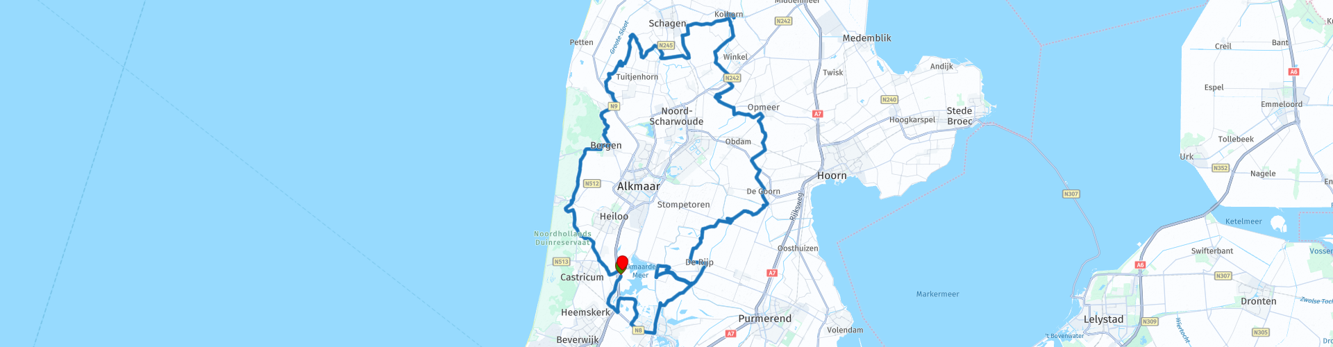
 The tour starts in Akersloot and via Uitgeest you soon arrive in a water-rich polder landscape. The meadows always seem surrounded by ditches, canals, ponds and lakes. The many reeds mark the water edges as rustling collars. What you will soon notice are the constantly changing height differences between water and land. For centuries, the inhabitants of this region fought against the ater, both salty and sweet. Sandwiched between the North Sea and South Sea, they managed to reclaim the area with varying degrees of success. But the threat of dyke breaches in the storm was always present. Yet they managed to control the ever-threatening flooding. After all, creative water management flowed through the veins that they also lived from it over time. The many drainage channels acted as waterways for trade, connecting the many hamlets and villages. And what remained dry was used for agriculture and animal husbandry. Although certainty was not given: many grazers got wet hooves with the unpredictably rising water.
Via Krommenie it goes over the Starnmeerdijk past Spijkerboor. Then you pass the island De Woude, which lies in the Alkmaarder Meer. There you can stroke the gas tap with policy until you reach De Rijp via East and West Graftdijk. This is a very well-preserved village with picturesque architecture such as the lovely town hall from 1630 and the white drawbridge. Both are very characteristic of De Rijp and on the characteristic roofs a certain mold will feel completely at home on 5 December. Although: the old Dutch were not interested in hordes of tourists, considering the width of the streets. So drive carefully, the many nostalgic vistas to the left and right also conceal incoming traffic. If you want to enjoy De Rijp in peace, enjoy the old village center on the terrace of the Wapen van Munster.
Past the traditionally rival village of Graft, over the Meer and Molendijk, you will pass watery polder ponds. Around you lots of meadow, water and birds of prey. It is called De Schermer here and this old polder has in its flag portrayed the pike and windmill vanes very understandably in its flag. The winding nature of the dyke and polder roads also reveals that the residents were forced to adapt to the water. But that is what motorcyclists enjoy today. And you can feel that in your hips.
Motorcyclists who do not come from the Randstad often speak with horror at the most densely populated part of the Netherlands. As if 5 million Dutch people live in a nightmare, which is absolutely not the case in this part of the Randstad. Rather you can speak of a polished wet dream. The polders will do even more for you when you give free rein to your cultural curiosity. The route takes you past small hamlets and past large farms with distinctive high roofs. Place names often end with Horn, such as Schermerhorn, Avenhorn and Barsingerhorn. This refers to an earlier exit to the sea or a sharp land corner. The TankTasTocht continues via mainly good roads, whereby the environment still deserves your full attention. In Oude Niedorp, for example, you come across the framework of a homeless church from the fourteenth century. In the town of Schagen it is time to tighten the reins and force the engine to a halt. To pose with the bronze Taurus, because in Schagen they are proud of double-muscled cows. By the way, to familiarize yourself with the West Frisian dialect: 'Skapen skating in Skagen' simply means 'Shearing sheep in Schagen'. They pronounce the Sch here as Sk. And now don't laugh.
After Sint-Maarten the route will guide you through the steep and winding West Frisian dike. The many curves indicate earlier dyke breaches, but nowadays it is a popular route along fields and water pools for motorcyclists. From the high dyke you can already see the wooded sea dunes in the front right of the cockpit. After the dike, continue straight in a westerly direction. Until the preprogrammed route takes you south from Petten to the North Sea. Perhaps the salty sea air will stimulate your imagination. As you reach the wooded area between Groet and Bergen, the striking green architectural style quickly diminishes. Sweet pine scent compensates for this loss. The traces of the fight against the water also seem to have dried up. The wet polders have been replaced by rolling forests. The lively artists' village of Bergen then brings you into doubt. Shortly after Schagen to take another break on one of the inviting terraces? Or to stretch your legs again to fully absorb the artistic tourist character of the village? In 1799 the Battle of Bergen was fought in this region. The French of the Batavian republic let the Anglo-Russian troops die. The Anglo-Russian alliance was common at the time, but nowadays highly curious. The bullet impacts resulting from this battle can be admired in the battered ruin church in the center of Bergen.
Via the Herenweg it goes past Egmond aan de Hoef. If you can't find an answer to the call of the sea: for those who want to feel the warm beach sand along their toes, turn towards Egmond aan Zee. The seaside town offers a great view of the North Sea. And when the motorcycle boots are knocked out, it is just a sea breeze from the dunes towards the end point in Akersloot. In short: a dyke of route through a hatch to the past. Touring along the inventiveness of an enterprising people, whose history we still cherish carefully. (Source: Promotor 03-2018).
Because I have not (yet) driven this route myself, this route gets 3 stars.


 Links
Links  Usage
Usage Want to download this route?
You can download the route for free without MyRoute-app account. To do so, open the route and click 'save as'. Want to edit this route?
No problem, start by opening the route. Follow the tutorial and create your personal MyRoute-app account. After registration, your trial starts automatically.  Disclaimer
Use of this GPS route is at your own expense and risk. The route has been carefully composed and checked by a MyRoute-app accredited RouteXpert for use on TomTom, Garmin and MyRoute-app Navigation.
Changes may nevertheless have occurred due to changed circumstances, road diversions or seasonal closures. We therefore recommend checking each route before use.
Preferably use the route track in your navigation system. More information about the use of MyRoute-app can be found on the website under 'Community' or 'Academy'.